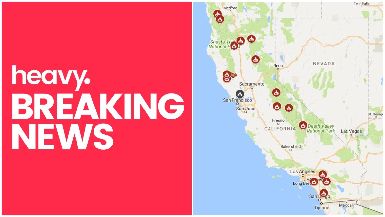
Inciweb California Fire Map Near Me
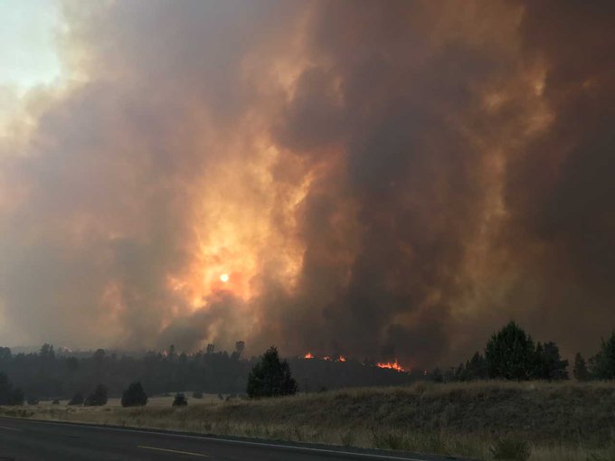
Fires in California continue to cause destruction on Friday, August 10. With the hot summer weather continuing, and a few thunderstorms periodically causing lightning strikes and winds that further fuel fires, you’ll want to track what is happening in your region. The Ferguson Fire, Carr Fire, Mendocino Complex Fire, and Holy Fire are causing issues and requiring evacuations, along with other fires that crop up unexpectedly. Since the fall, thousands of people in California have lost their homes and others have lost their lives from the fires. Read on to learn all the details about the current fires in California as of Friday, August 10, with a roundup of maps of the larger fires around the state, their containment levels, and where they are located. News is constantly changing, so call your local officials if you are concerned about evacuations near you. (If you are interested in reading about Forrest Gordon Clark, who was arrested in connection with the Holy Fire, see Heavy’s story here.)
Interactive Maps of California Fires
This map below is an interactive map of some of the bigger fires in California, constantly being updated, provided by CAL FIRE and Google. Fires in red are active and fires in black are contained. Read the next section for details about the fires listed on the map.
The California Governor’s office has another active fire map for comparison, which is embedded below. This map periodically is made available only to those with a login, so if it’s not available when you’re reading this story, it might be released to the public again later. The map was updated on August 9.
Below is another active fire map from Google’s Crisis Map. Zoom in to see areas of interest.
Next are more specific details on the fires for August 10. The details are extensive, so if you are looking for a specific fire, search for the name so you can find it faster, or just scroll down and look at the fires, listed in alphabetical order.
List of Active Fires in California as of August 10
Here are the active fires and updates about them, per CAL FIRE, as of August 10. Most of these are in alphabetical order, but newer fires not yet listed on the CAL FIRE map may be included in a separate section at the end.
Carr Fire
The Carr Fire is off Highway 299 and Carr Powerhouse Road in Whiskeytown (Shasta County.) You can see an interactive map above. Both the acreage and the containment have increased slightly in the last day. Today it is 181,496 acres and 51 percent contained, according to CAL FIRE. There are 1,077 residences that were destroyed, 22 commercial structures, and 500 outbuildings. 528 structures are still threatened by the fire. The fire was caused by a vehicle’s mechanical failure.
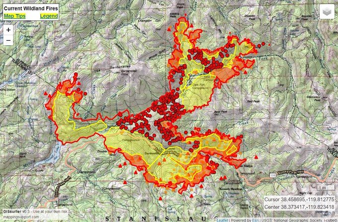
8/10 Friday #CarrFire. See “Legend” and “Map tips” links (upper left corner) to get the most benefit from the map. Open online map: t.co/7zqh0IAbQS #GeoSpatial

You can get the most latest updates on evacuations from the Shasta County Sheriff’s Office here.
The following mandatory evacuations are still in place as of August 9, 7 p.m.:
Shasta County:
- WhiskeyTown Park
- Rainbow Lake
Trinity County:
- Trinity/Shasta County Line at Buckhorn Summit Rd W. to Trinity Dam Rd. All roads w/in this area North of Hwy 299
- Deadwood Road east of Trinity Dam Blvd
- Lewiston Turn Pike East of Trinity Dam Blvd
- Trinity Dam at Trinity Dam Blvd.
If you have any questions, call the Shasta County Sheriff’s Department for clarifications.
Assistance and evacuation centers as of August 9:
- Shasta College at 11555 Old Oregon Trail Redding, CA
- Trinity High School at 321 Victory Lane, Weaverville CA
- Disaster Recovery Center at the old Kmart building at 2685 Hilltop Dr. in Redding, from 9 a.m. to 7 p.m. daily
Animal evacuation center as of August 7:
- Small Animal – Haven Humane 9417 East Side Drive Redding, Ca.
Road closures: See this webpage for a list of road closures.
Per CAL FIRE: “For information on evacuation notifications visit http://www.shascom911.com. Click for the most up to date evacuation orders and advisories at the Shasta County Sheriff’s page.”
You can also see map of repopulation efforts here.
Cranston Fire
This fire is off Highway 74 and Control Road. It’s 13,139 acres and 100 percent contained as of August 10. There are several sources you can tune into for continuing updates about the Cranston fire.
- San Bernardino NF Facebook
- San Bernardino NF Twitter
- Riverside Sheriff’s station: Call 951-791-3400 with questions (or 911 if you’re concerned about evacuations in your area)
- Inciweb’s Cranston Fire webpage
Brandon McGlover was arrested on suspicion of starting five fires, including the Cranston fire. Read about him in Heavy’s story here.
Donnell Fire
8/10 Friday #DonnellFire. Operations map for today. 9.1MB PDF file: 8/7 Tuesday #DonnellFire. Operations map for today. 4.9MB PDF file: t.co/AAzHcUHDve #GeoSpatial

This fire is in the Stanislaus National Forest and is 21,097 acres with 6 percent containment, as of August 9.
8/10 Friday #DonnellFire. See “Legend” and “Map tips” links (upper left corner) to get the most benefit from the map. Open online map: t.co/J5Dsg6LyPh #GeoSpatial
The fire is active on the southeast flank toward Kennedy Meadows. On the north, Spicer Meadow and Carson Iceberg Wilderness are closed.
InciwebDonnell Fire Map
Fourteen out of 16 cabins in the Wagner Tract, along with the Dardanelle Store, were destroyed in the fire. None of the Riverside Tract cabins were destroyed.
Highway 108 is still closed at Eagle Meadow Road from the west and at the top of Sonora Pass from the east side, according to Inciweb on August 9. The gate at the junction of Highway 4 and Highlands Lake Road is also closed. The Pacific Crest Trail is closed between Highway 108 and Highway 4 for public safety.
The fire started at the inlet of the Donnell Reservoir, and still burns along the Middle Fork of the Stanislaus River in inaccessible terrain. It spread to both sides of Highway 108 near Brightman.
Mandatory evacuations are still in effect in the following areas as of August 9: “Along Highway 108 from Eagle Meadow Road to Kennedy Meadows (all residences and campgrounds) as well as all along Eagle Meadow Road (5N01) and the Clark Fork Road area. No new mandatory evacuations have been ordered.” An evacuation advisory is in effect for the Mill Creek area. (Inciweb’s Donnell Fire page is currently down as of August 10. We will update this section once the page is live again.)
Ferguson Fire (Yosemite Fire)
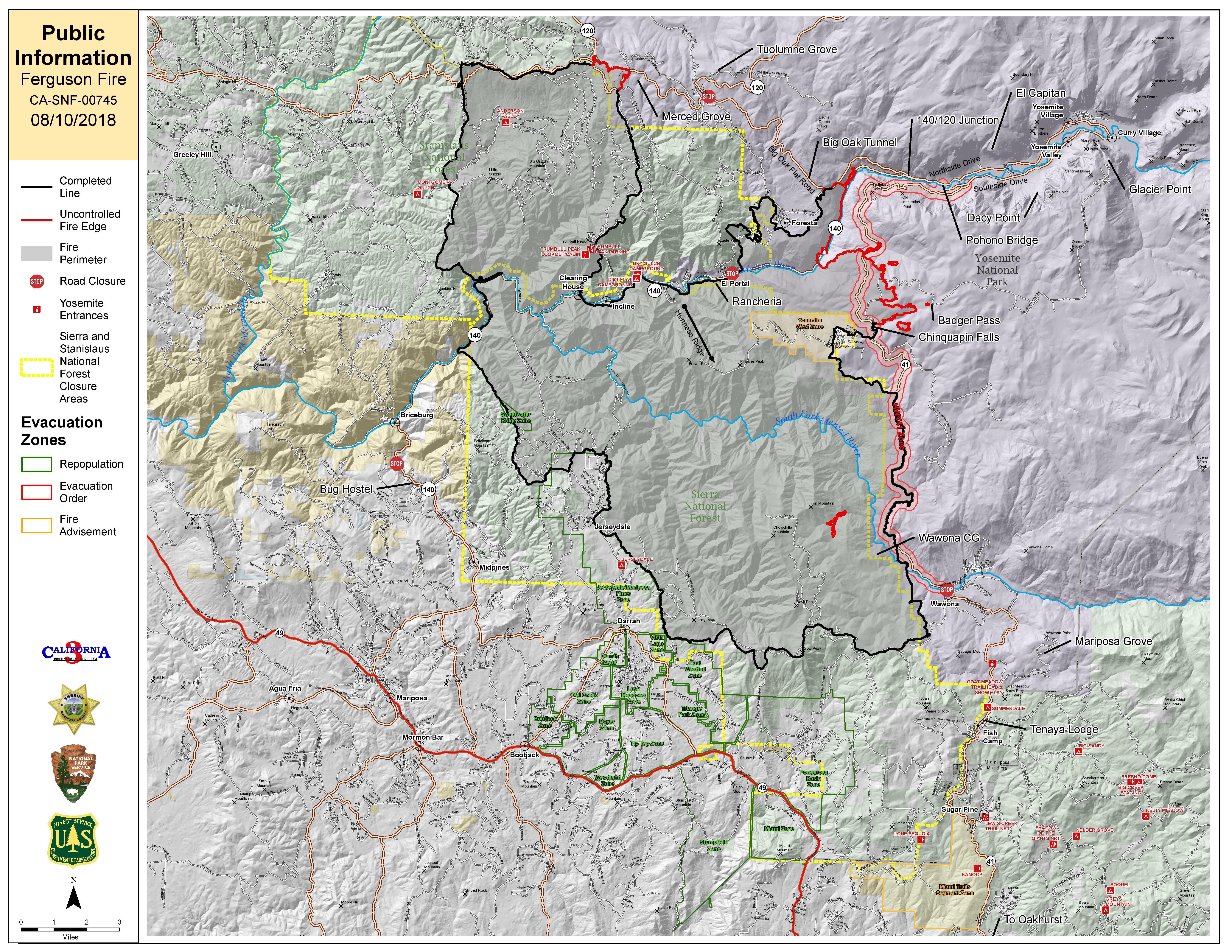
Ferguson Fire Map
This fire is off Highway 140 and Hite Cove, near El Portal in Mariposa County. It’s burning west of Yosemite National Park. It is 95,544 acres and 80 percent contained as of August 10 (up from 42 percent containment just two days before.) Significant strides are being made to get this fire under control. Below is another map. You can click on the link to see an interactive version.
Friday 8/10 #FergusonFire zoomed in a bit on the only real active area. Map shows latest fire perimeter and satellite hotspots. Open online map: t.co/Cv0VK9r5ME #GeoSpatial

The fire began on July 13 in the Merced River canyon near El Portal around 10:35 p.m., Merced Sun Star reported, and at the time was less than 200 acres. It grew substantially from there. According to Inciweb, the fire is located at 37.652 latitude, -119.881 longitude. The cause of the fire in the Savage Trading Post area is currently unknown. It was burning in very rough terrain with little-to-no access roads. The fire is the largest in Sierra National Forest history. Firefighters are progressing toward full containment, with the objective of keeping it out of Yosemite Valley.
The following areas also remain closed, according to Inciweb: “U.S Forest Service: A closure order is in effect Groveland Ranger District in the vicinity of the Ferguson Fire on the Stanislaus National Forest. The Sierra National Forest Closure due to the Ferguson Fire can be found at the Sierra National Forest website… Yosemite National Park: Yosemite Valley, Wawona Road, the Mariposa and Merced groves of giant sequoias, Hetch Hetchy, among other areas, are closed. For more information, go to nps.gov/yose or call 209-372-0200.”
A large portion of Yosemite Park remains open. Tioga Road from Tioga Pass to White Wolf is open to all visitors and vehicles, Inciweb reported. Most trails and campgrounds on this route are open.
Inciweb says the following about animal shelters: “The Central CA Animal Disaster Team (CCADT) continues to coordinate small animal sheltering with the Mariposa SPCA and Red Cross Central Valley. If residents who are under mandatory evacuations orders need assistance with small animal sheltering, please contact the CCADT at (888)402-2238 (Ext.700) Large animals will be sheltered at the Mariposa Fairgrounds. For Animal evacuations, please contact the sheriff’s office at (206)966-3615.”
Garner Complex Fire
CAL FIRE is helping the Oregon Department of Forestry with this fire, located west of Highway 199, four miles northwest of Cave Junction in Oregon. As of August 9, it’s 8,886 acres and 85 percent contained. It was caused by lightning. This fire designation includes the following fires: Grave Creek 1-4, Ditch Creek, 416, Spencer 1-3, Pleasant Creek, and King Mountain. It was caused by lightning. Taylor Creek was once considered part of this fire but now is being managed separately. At noon on August 9, Southwest Oregon District will assume command of the fire.
The fire is so well under control that Inciweb is no longer updating the fire.
Georges Fire
This fire is off Hogack and Whitney Portal Road in Alabama Hills, Inyo County. It’s now 2,883 acres and 70 percent contained. It was caused by lightning. No structures were destroyed. The areas in the valley floor are safely contained, but the western fireline is in steep, inaccessible terrain that firefighters can’t access. There may be continued fire activity as the fuel dries out, but the fire should eventually “rock out” when it reaches granite cliffs and no fuel, Inciweb reported on August 6. It contains no threat to life or property, Inciweb emphasized, and has been inactive for several weeks.
Hat Fire
Per CAL FIRE, this fire quickly grew from just 100 acres or so yesterday to 2,500 acres and 15 percent contained today. It’s at Highway 299 east and Fish Hatchery Road, northeast of Burney.
The #HatFire explodes overnight to 2,500 acres near Fall River Mills
t.co/bkhbxTlfuA
The following evacuations have been ordered: “HWY 299E from Pit 1 Grade to area of Glenburn Rd and all homes west of Glenburn Rd. Fall River Mills area. Due to power outage in McArthur and surrounding areas, the evacuation center is moving to Adin Community Center.”
Highway 299E, eastbound closure at Cassel Road and westbound closure at Main St. in Fall River Mills, is closed.
Hirz Fire
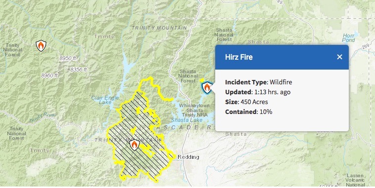
InciwebHirz Fire Map
This fire is not a CAL FIRE but it is listed on CAL FIRE’s website. It’s 450 acres located north of Moore Creek Campground and 10 percent contained. It’s 11 miles east of Interstate 5 on Gillman Road near Lakehead, California.
#HirzFire Update for August 10 t.co/4fWiE4oGdq

The cause is under investigation. This listing is actually three fihttps://twitter.com/ShastaTrinityNF/status/1028003860785192960res that total 100 acres near Hirz Bay and Moore Creek Campground off Gilman Road on the McCloud Arm of Shasta Lake. Be cautious of fire traffic on Gilman Road.
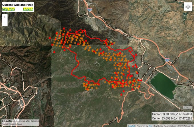
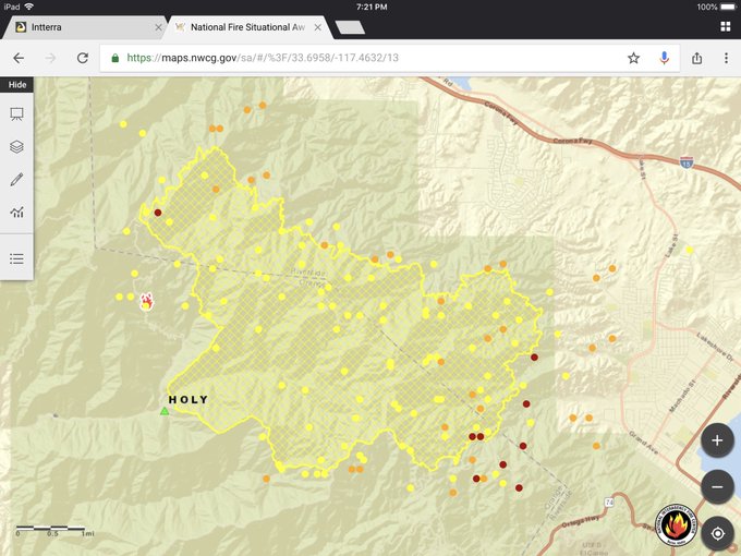
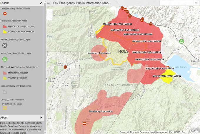
Holy Fire
The Holy Fire just formed on August 6 in the afternoon and quickly grew. You can see an interactive map of the Holy Fire above or here. A few more maps are below, many updated for August 10.
8/10 Friday#HolyFire. Latest perimeter from infrared flight late yesterday with help from @pjdohertygis. Map also always shows latest satellite hotspots. See “Legend” and “Map tips” links in upper left corner. Open online map: t.co/bUkdfmYsek #GeoSpatial
Firefighters battle #HolyFire as it approaches structures. The fire has burned over 18,000 acres northwest of Lake Elsinore, California. t.co/cRs8TXjMBv

1️⃣ #HolyFire perimeter and #MODIS hot spots (as of 1925 Pacific on 09 August 2018).
2️⃣ Fire information – Over 10,000 acres and 5% contained.
#EnterpriseGeospatialPortal (powered by #Intterra)
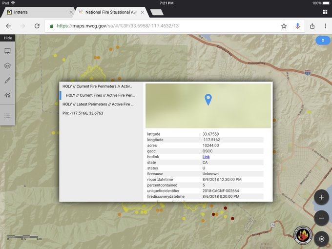
The Holy Fire is in Orange County, off Holy Jim Canyon Road, west of the North Main Divide. The fire started Monday afternoon and quickly grew to more than 100 acres, The OCR reported. Then it grew to 1,000 acres and by Tuesday, August 7, it was at 4,000 acres. As of August 9, the fire has more than doubled in size and was 9,614 acres and 5 percent contained. Then today, August 10, it was reported to be nearly doubled in size yet again: 18,137 acres and 5 percent contained.
The cause is under investigation, but authorities have arrested Forrest Gordon Clark on suspicion of felony arson. Read more about Clark in Heavy’s story here.
*IMPORTANT* #HolyFire Evacuation Information from Orange County Sheriff – bookmark this map! Looks like they have Orange County and Riverside County covered. t.co/enqj9WyNGO
A public information hotline has been set up at 714-628-7085 for the Holy Jim area.More than 21,000 people have been evacuated, including about 7,500 homes as of Friday, August 10, KTLA 5 reported. Twelve structures burned when the fire first started on Monday, but so far no additional structures have been lost.
No major injuries have been reported from the fire.
Mandatory evacuations were ordered in McVicker Canyon, Rice Canyon, Horsethief Canyon, El Cariso, Rancho Capistrano, Blue Jay, Indian Canyon, Glen Eden, Sycamore Creek and Mayhew Canyon, ABC 7 reported. In addition, all homes on the mountainside of Lake Street and southwest of Grand Avenue to Ortega Highway are also under a mandatory evacuation as of the morning of August 10.
Voluntary evacuations were issued for:
- Highway 74 (Ortega Highway) west from Lookout Restaurant to Nichols Institute and all connecting roads in the communities of Rancho Capistrano, El Cariso Village and Blue Jay. Residents are advised to exit west to Orange County to avoid fire equipment coming up on the Elsinore side.
- Highway 74 eastbound is also closed.
- According to Cleveland National Forest, a new voluntary evacuation notice was issued for the Machado community on August 9.
Here are the evacuation centers, according to ABC 7:
- A care and reception center is at Temescal Canyon High School at 28755 El Toro Road in Lake Elsinore.
- An evacuation center is at San Juan Hills High School at 29211 Stallion Ridge in San Juan Capistrano.
- Animal Friends of the Valley is at capacity, but Riverside County Animal Services employees are accepting animals at Temescal Canyon High School and at the San Jacinto shelter. CAll 951-358-7387 for details.
The fire is dangerously close to homes in the Lake Elsinore-Corona area.
The fire is expected to continue to spread south, east, and north, but only limited spread west, Inciweb reported.
Lions Fire
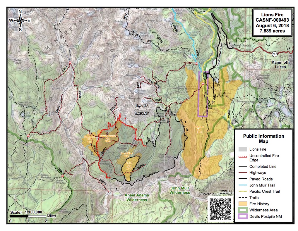
InciwebLions Fire Map
This fire is listed on the CAL FIRE map. It’s 8,779 acres and 70 percent contained as of August 9 at 9:40 a.m. It’s located seven miles southwest of Mammoth Lakes. It was caused by lightning. Continued spread to the north and west with group torching is expected. Most of the fire is on the Sierra National Forest, but about 1,600 acres are on the Inyo National Forest. The south and east flanks of the fire are inactive and contained. The southwest flank remains active.
Regarding closures, Inciweb noted on August 8: “There is an emergency trail closure for the Fern Lake and Beck Lake Trails on the Inyo National Forest and emergency trail closures and a Forest Order to close the area on the Sierra National Forest (west of the North Fork of the San Joaquin River, north of the Middle Fork of the San Joaquin River and South of Iron Creek).”
Murphy Fire
#MurphyFire Plumas County
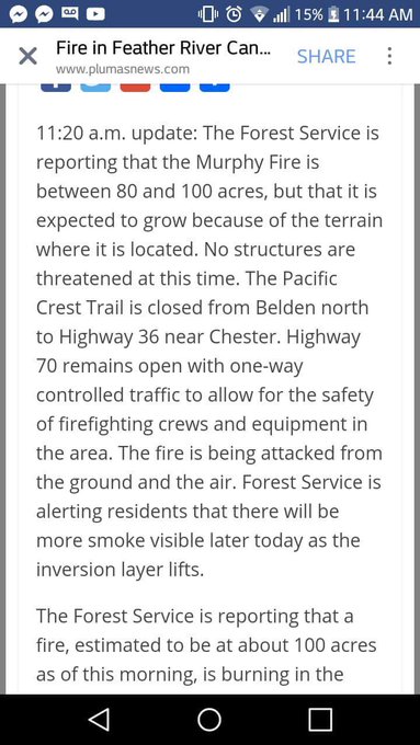
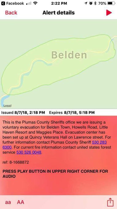
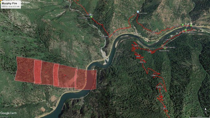
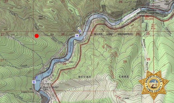
This fire is being handled by the Plumas National Forest and is listed on CAL FIRE’s map. It’s about 117 acres and is near the Pacific Crest Trail, 44 miles from Highway 70 near Belden to Highway 36. The cause is under investigation. It’s 30 percent contained.
#MurphyFire holding at 100 acres. Rolling rocks & other debris in the roadway on Hwy 70. Voluntary evacs for tiny Canyon communities. 📷: USFS Plumas
Highway 70 is open, according to Inciweb on August 9, as well as Feather River Canyon campgrounds and businesses. Keep updated on Facebook here.
According to Inciweb: “A Forest Closure is in effect for the area around the Murphy Fire. For more information, visit https://www.fs.usda.gov/alerts/plumas/alerts-notices.”
Natchez Fire
Here’s a useful map which shows all the fires in southwest Oregon. #HendrixFire #GarnerComplex #SugarPineFire #KlondikeFire #NatchezFire #SouthUmpquaFire #TimberCrater6Fire
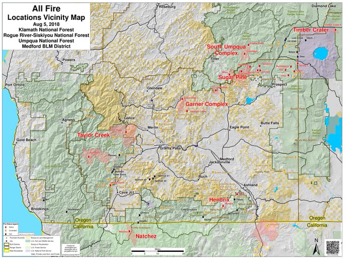
This fire falls under the jurisdiction of the Oregon Department of Forestry Fire, but is also listed on the CAL FIRE map. It’s 11,600 acres and 50 percent contained as of August 9. It was caused by lightning. It’s located 15 miles southeast of Cave Junction, Oregon, located on the Oregon/California border between Happy Camp, California and Cave Junction, Oregon. Some active surface spread is still expected.
1️⃣ #NatchezFire perimeter and #MODIS hot spots (as of 1950 Pacific on 09 August). Getting close to the Oregon border.
2️⃣ More fire info: 11,600 acres and 52% contained.
#EnterpriseGeospatialPortal (powered by #Intterra) #CAfire #wildfires

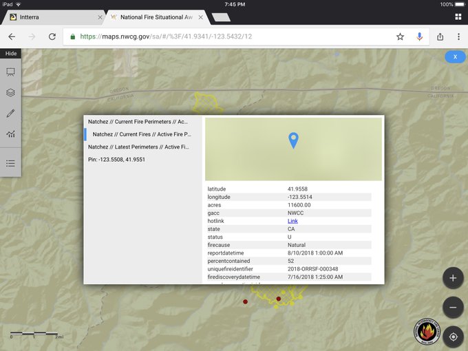
The community of Sunstar is still on a Level 1 evacuation “Ready” status as of August 8. For Del Norte County emergency notification information, visit: http://www.co.del-norte.ca.us/departments/administration/emergency-services. An evacuation order was issued on August 1 for two residences near the fire.
Ranch Fire (Mendocino Complex Fire)
Thursday 8/9 #RanchFire and #RiverFire. Managed as #MendocinoComplex. See “Legend” and “Map tips” links (upper left corner) to get the most benefit from the map. Open online map: t.co/01IPvhzV6d #GeoSpatial
This fire, now known as the largest in California’s history, is off Highway 20 near Potter Valley, northeast of Ukiah in Mendocino/Lake/Colusa Counties. It’s now 258,527 acres and 53 percent contained as of August 10 at 8 a.m. (That’s a significant containment increase from August 7.) So far, 119 residences have been destroyed and more than 9,000 structures are threatened. (The total for the entire Mendocino Complex fire is 305,152 acres and 52 percent containment.) There have been no fatalities.
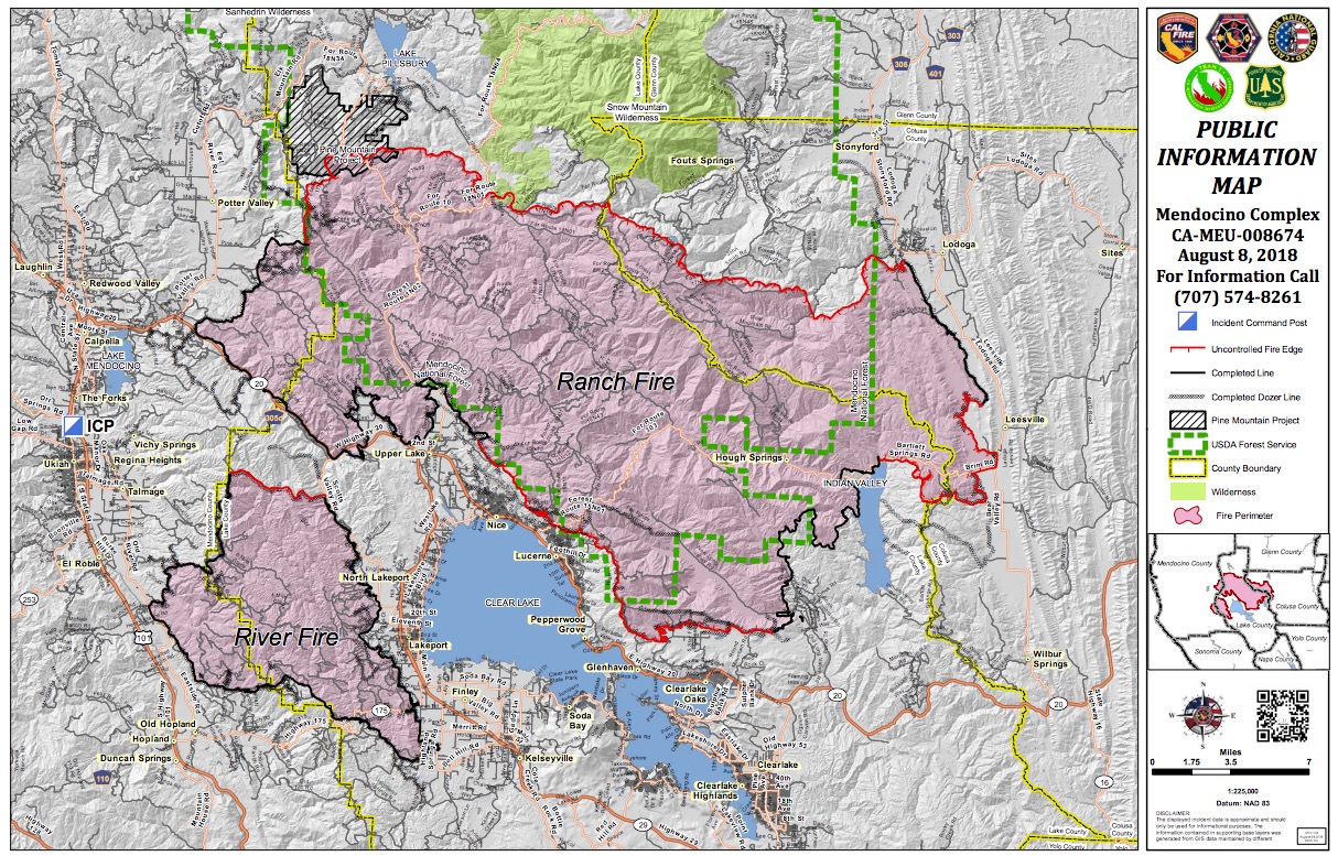
InciwebMendocino Complex Fire Map
See the latest evacuation orders and advisories at the Mendocino County Sheriff’s Facebook page , Colusa County Facebook page, and the Lake County Sheriff’s Facebook page. The following mandatory evacuations are in place for the Ranch and River fires as of August 10 at 8 a.m.
Mendocino County:
- South of Eel River, west of the Mendocino- Lake county line, east of 10500 block of Mid Mountain Road, and north of Pine Ave. Does not includes residents on Pine Ave.
Lake County:
- East of the Lake-Mendocino County Line, south of the Lake-MendocinoGlenn County Line, west of the LakeColusa County Line, north of the fire perimeter and the Mendocino National Forest boundary.
Colusa County:
- South of the Glenn/Colusa county line, east of the Lake/Colusa County Line, north of Highway SR-20, and west of Bear Valley/Leesville Ladoga Road/Sites Ladoga Road/CountyRoad 401.
The following evacuation advisories/warnings are in place:
Mendocino County
- Mendocino County north of Mid Mountain Road, south of the Eel River, west of the 10500 Block of Mid Mountain Road, and east of East Potters Valley/Eel River Roads.
- The Bureau of Land Management closure of the Cow Mountain Recreation Area remains in effect.County Road 308, east of the Mendocino National Forest Boundary.
Glenn County:
- North of the Glenn County/Colusa County Line, west of County Road 306, south of County Road 308, east of the Mendocino National Forest Boundary.
Lake County:
- North of Clear Lake Water’s Edge, North of 11th Street, East of Highway 29, South of the fire perimeter, and west of New Long Valley Road.
- North of SR 20, east of New Long Valley Road, south of Bartlett Springs Road, west of Lake-Colusa County Line
Here is a list of evacuation centers:
- Mendocino College, Dance Room at 1000 Hensley Creek Road, Ukiah
- Lower Lake High School, 9430 Lake Street, Lower Lake
- Twin Pine Casino, 22223 CA-29, Middletown
- Middletown High School, 20932 Big Canyon Road, Middletown (AT CAPACITY)
- Middletown Middle School, 15846 Wardlaw St. Middletown, CA 95461
- Mountain Vista Middle School, 5081 Konocti Rd. Kelseyville, CA 95451
- Colusa County Veterans Hall,108 E. Main Street Colusa, CA
Animal evacuation centers:
- Redwood Riders Arena, 8300 East Road, Redwood Valley is accepting horses
- Animal Care, 298 Plant Road, Ukiah is accepting small animals
For updated details, call 707-574-8261 in Mendocino County.
Rangeland Fire / Ramona Fire
#RangelandFire #MVU Hwy.78 x. Horizon View Dr just north of Ramona. 15+ acres RROS, potential for 100.
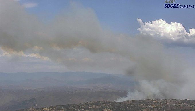
Dubbed the Rangeland Fire, this is just recently added to CAL FIRE’s map. The fire is 250 acres and 60 percent contained. Forward spread has been stopped. The fire is off Rangeland Road and Highway 78 in Ramona (San Diego County).
Firefighters are battling a 75 acre fire off Rangeland Road and Highway 78 in Ramona (San Diego County). #RangelandFire t.co/5O3WRcz4DC

River Fire (Mendocino Complex)
Thursday 8/9 #RanchFire and #RiverFire. Managed as #MendocinoComplex. See “Legend” and “Map tips” links (upper left corner) to get the most benefit from the map. Open online map: t.co/01IPvhzV6d #GeoSpatial
Per CAL FIRE, the River Fire is now 48,920 acres and 87 percent contained. For details about evacuations etc., see the Ranch Fire update above.
Taylor Creek Fire
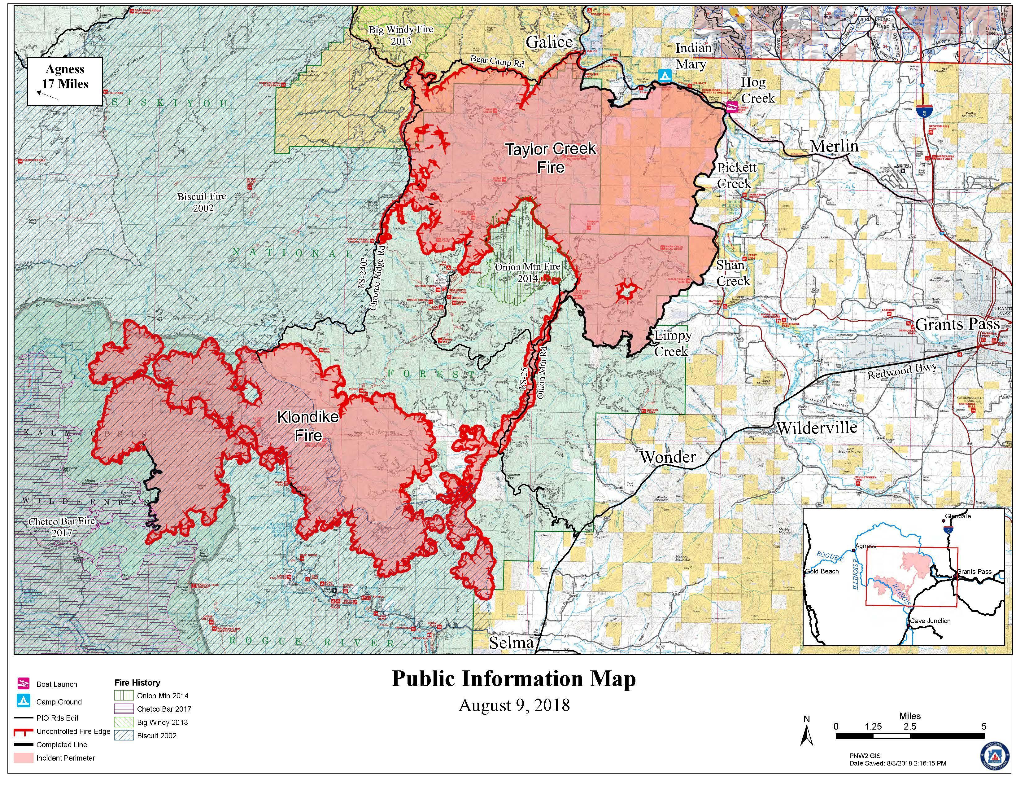
InciwebTaylor Creek Fire Map August 9
Once considered part of the Garner Complex Fire, it’s now being managed separately, according to Inciweb. If you have not signed up for Josephine County Citizen’s Alert, Josephine County’s emergency notification system, you can sign up on line at www.rvem.org. It’s actually an Oregon fire.
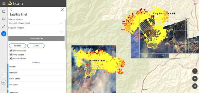
#Intterra tools have several layers that can be turned on and off. This image shows 28 Jul #WorldView3 imagery acquired over the #KlondikeFire and #TaylorCreekFire, with #MODIS / #VIIRS data and #GeoMac perimeters, all displayed in the Satellite Intel Tool. @DigitalGlobe #ORfire
It’s 42,996 acres in size and 38 percent contained as of August 9. You can find the latest evacuation updates on the Josephine County Emergency Management Facebook page. An evacuation downgrade was issued on August 9 for areas along the north edge of the Taylor Creek Fire, west of Merlin, KDRV reported. 6755 through 11411 Galice Road, and 600 Taylor Creek Road are in a Level 1 “Be Ready” status.
You can view an interactive map of the fire here.
The Red Cross evacuation shelter remains active at Grants Pass High School (830 NE 9th St, Grants Pass, OR 97526).
The Fire Information Center can be reached at 541-474-5305 and is staffed from 8:00am to 8:00pm each day.
An animal evacuation center is open at the Josephine County Fairgrounds Floral Building located at 1451 Fairgrounds Road, Grants Pass, OR.
Valley Fire
The Valley fire is 1,350 acres and 56 percent contained. It’s at the Valley of the Falls Dr. and Service Road 1S08. According to Inciweb, minimal to no growth is expected and very little fire spread is expected. However, hot and dry conditions have helped the fire stay active. Inciweb isn’t actively updating this every day.
Whaleback Fire
This fire is now 18,703 acres and 100 percent contained. According to Inciweb on August 9, crews are still engaged with the fire. The fire is located off Whaleback Mountain and Antelope Valley Road, west of Spaulding in Lassen County. For updates on this fire, call (530) 252-6450. The forest closure is still in effect for the area around the fire.