NWS Hurricane Lane spaghetti models show the path imperiling Hawaii.
Hurricane Lane is threatening Hawaii with the August 22, 2018 update from the Central Pacific Hurricane Center warning that “the center of Lane will track dangerously close to the Hawaiian Islands from Thursday through Saturday. ”
Some of the recent spaghetti models and other path maps show a troubling track for the storm, although there is some recent hope. According to Accuweather, impact could be lessened if the hurricane continues to track to the west before it turns north. Here is a map published by Google for Hurricane Lane:
As of 8 p.m. on August 22, 2018, the Central Pacific Hurricane Center’s most recent update for the storm, published around 2 p.m., read:
DANGEROUS HURRICANE LANE TRACKING WEST-NORTHWEST TO THE SOUTH OF THE MAIN HAWAIIAN ISLANDS
200 PM HST Wed Aug 22 2018
Location: 15.6N 156.4W
Maximum sustained winds: 150 MPH
Moving: WNW at 8 MPH
Minimum pressure: 937 MB
Hurricane Lane was upgraded to a Category 4 storm on August 22, 2018. Maps and trackers chart its path.
Where to Find Updated Spaghetti Models
Hurricane Lane is still a MAJOR hurricane and is the STRONGEST hurricane to track within 300 miles of Hawaii according to NOAA. #12News

You can find continually updated spaghetti models for Hurricane Lane on the Cyclocane site here. The highest predicted winds for the hurricane are a median of 125 knots, according to the site. You can see the Cyclocane tracking page for Hurricane Lane here. It contains additional maps and weather information.
In addition, the Tropical Cyclone Guidance Project of NCAR offers constantly updated spaghetti model plots and other maps to track the storm. You can access them here. For example, here is an August 22, 2018 spaghetti model plot from NCAR.
I am very cautiously hopeful about Hurricane Lane. Latest forecast track has the center of the storm a little farther offshore than Tues. As you know, this can change significantly with these large storms, so Hawaiians are doing the right thing by taking it seriously. @News3LV
According to The National Weather Service, Hurricane Lane “continues WNW toward the state. Maui County has been upgraded to a Hurricane Warning, and a Hurricane Watch has been issued for Kauai County.”
5am: #Lane is a category 4 storm this morning as it continues WNW toward the state. Maui County has been upgraded to a Hurricane Warning, and a Hurricane Watch has been issued for Kauai County. Visit t.co/fUefWa9aTA for a full list of current watches and warnings #hiwx

You can find a list of watches and warnings put out by the National Weather Service for Hawaii here.
#NOAA scientists get up-close-and-personal with #HurricaneLane , flying through the eye of the powerful storm bearing down on the Hawaiian islands. t.co/zEhBRHDc3f h/t @northwind1ndn

Here’s another map:
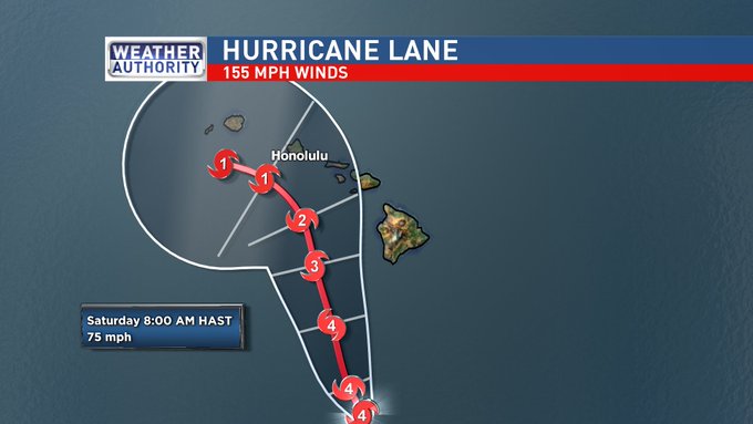
Here’s a cone map showing the path of Hurricane Lane:
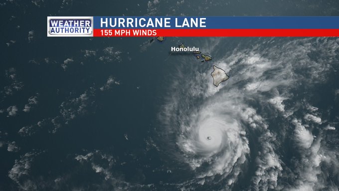
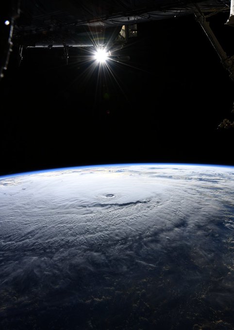
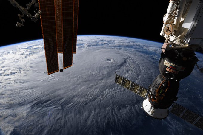
Here’s an amazing view of Hurricane Lane from the International Space Station, per the National Weather Service:
Hurricane Lane as viewed this morning from the International Space Station.
According to the Central Pacific Hurricane Center, as of roughly noon on August 22, 2018:
Major Hurricane Lane is passing roughly 250 miles south of the Big Island late this morning and has started a turn towards the northwest in line with the Central Pacific Hurricane Center forecast. The center of Lane will track dangerously close to the Hawaiian Islands from Thursday through Saturday. Regardless of the exact track of the storm center, life threatening impacts are likely over some areas as this strong hurricane makes its closest approach. Just a reminder that impacts from a hurricane extend far from the center of the storm and slight changes to the forecast track this close to the islands will produce rapid changes to the local forecast impacts.
The onset of damaging tropical storm-force winds on the Big Island could start later this evening, with dangerous hurricane force winds starting in the overnight hours. In Maui County, damaging winds could begin as early as Thursday afternoon, with dangerous hurricane force winds possible starting by Thursday night. On Oahu, damaging winds could begin as early as Thursday evening, with dangerous hurricane force winds possible by Friday morning. Hurricane Warnings may need to be expanded to include other islands as Lane draws closer.
Bands of intense showers and thunderstorms surrounding Lane will begin to spread across the state from the southeast towards the northwest. Excessive rainfall is possible which could lead to deadly flash flooding, landslides and mudslides. Flooding can occur even in areas not usually prone to flooding. Storm total rainfall amounts greater than 20 inches are possible.
Swell generated by Lane will produce very large and rough surf, with dangerous rip currents along south, southeast and southwest facing shores.
Tornadoes and large waterspouts will be possible with Lane, mainly along and to the right of the track of the hurricane.
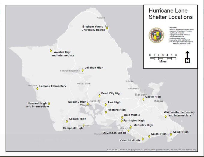
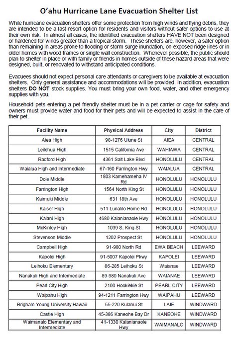
The government has published lists of shelters.
O’ahu Hurricane Lane Evacuation Shelter List for Hurricane #Lane. Please shelter in place if safe and when possible – our shelters are intended to be a last resort option for residents and visitors without safer options to use at their own risk.
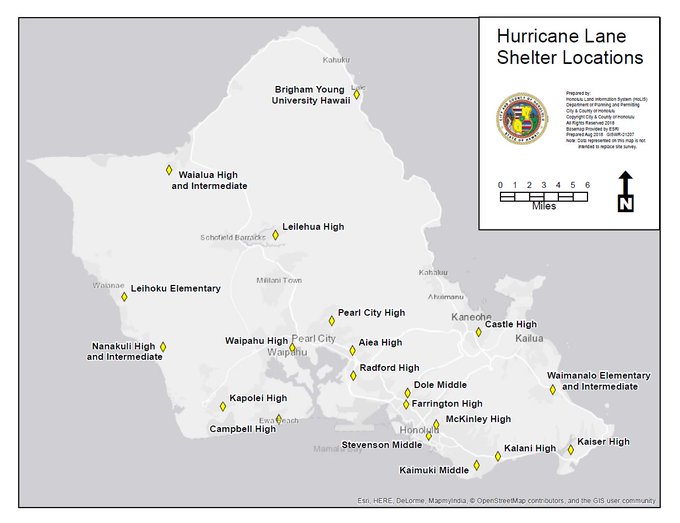
Map of O’ahu Evacuation Shelters. Please shelter in place if safe and when possible – these shelters are intended to be a last resort option for residents and visitors without safer options to use at their own risk. Follow @HonoluluGov for more info #HurricaneLane