Inciweb Mendocino Ranch Fire Map
The Mendocino Complex Fire is the largest fire in California’s history, and it includes the Ranch and River Fires, which are totaling more than 300,000 acres as of August 8. Here are updated details with interactive maps of the fires’ current locations.
Firefighters Gained 26 Percent on Containing the Ranch Fire on August 8
The Ranch Fire is currently 251,166 acres and 46 percent contained. This is actually good news. Although the fire has grown some, yesterday it was only 20 percent contained. A 26 percent containment in one day is a sign that firefighters may be getting control of this fire, as long as the weather cooperates. High, gusty winds can sometimes cause complications with fire suppression.
The River Fire, which is also part of the Mendocino Complex fire, is holding at 48,920 acres, and an increase in containment of 3 percent for a total of 81 percent of the fire contained.
The total acreage for the Mendocino Complex fire is 300,086 acres and 47 percent contained. Officials are hopeful that they will have full containment by September 1. So far, there have been no fatalities from these fires. However, 116 residences have been destroyed and more than 10,000 structures are currently threatened, according to CAL FIRE.
Here Are Interactive Maps of the Mendocino Complex Fire
Here is a map of the two fires, as released by CAL FIRE on August 8:
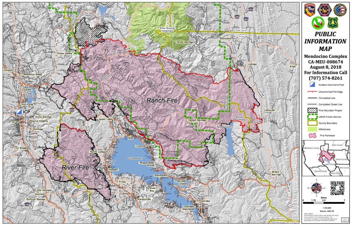
InciwebMendocino Complex Fire Map
You can see a full PDF of the map here.
Below is an interactive map of the River and Ranch Fires, part of the greater Mendocino Complex Fire. Click on the box on the upper right to see a full-sized map. This includes advisory evacuations, mandatory evacuations, and emergency shelter information. It’s an unofficial map, not provided by an official source.
You can also view the following interactive maps to get a better idea of the Mendocino Complex Fire’s location. Just zoom in to the individual Ranch or River fires to get a better idea of where they are located near you. This map below is an official interactive map of some of the bigger fires in California, constantly being updated, provided by CAL FIRE and Google. Fires in red are active and fires in black are contained. Zoom in to the Ranch and River fires for more details.
Next is the California Governor’s office’s fire map for comparison, which is embedded below. Zoom into the Ranch Fire or click on the Ranch Fire’s name for more details. This map sometimes requires a login and sometimes it doesn’t. So if it’s not available for you, just move on to the next map.
Next is another active fire map from Google’s Crisis Map. Zoom in to areas of interest.
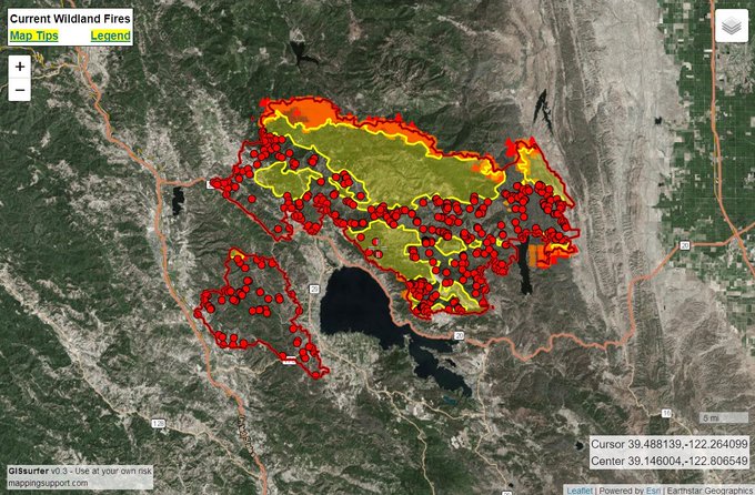
If you click on the map below, you’ll see another interactive map provided by Mapping Support:
Wednesday 8/8 #RanchFire and #RiverFire. Managed as #MendocinoComplex. See “Legend” and “Map tips” links (upper left corner) to get the most benefit from the map. Open online map: t.co/01IPvhzV6d #GeoSpatial
Evacuation Details for the Mendocino Complex Fires
The Mendocino Complex fire is burning around Clear Lake and in several northern California counties, CNN reported. It’s now the largest fire in California’s history.
Exhausted firefighters have been working nonstop and no deaths have resulted from the fire. But resources are also being spent on the Holy Fire in Orange County, which has grown to more than 4,000 acres.
So far, 75 residences have been destroyed from the Ranch Fire, and more than 11,000 structures are threatened. The fire remained active overnight, spreading north and east.
The following mandatory evacuations are in place for the Ranch and River fires as of August 8 at 7 a.m.
Mendocino County:
- South of Eel River, west of the MendocinoLake county line, east of 10500 block of Mid Mountain Road, and north of Pine Ave.
Lake County:
- East of the Lake-Mendocino County Line, south of the Lake-Mendocino-Glenn County Line, west of the Lake-Colusa County Line, north of SR 20 and the Mendocino National Forest boundary.
Colusa County:
- South of the Glenn/Colusa county line, east of the Lake/Colusa County Line, north of Highway SR-20, and west of Bear Valley/Leesville Ladoga Road/Sites Ladoga Road/County Road 401.
The following evacuation advisories/warnings are in place:
Mendocino County
- Mendocino County north of Mid Mountain Road, south of the Eel River, west of the 10500 Block of Mid Mountain Road, and east of East Potters Valley/Eel River Roads. remains in a mandatory evacuation warning.
- The Bureau of Land Management closure of the Cow Mountain Recreation Area remains in effect.
Glenn County:
- North of the Glenn County/Colusa County Line, west of County Road 306, south of County Road 308, east of the Mendocino National Forest Boundary.
Here is a list of evacuation centers:
- Mendocino College, Dance Room at 1000 Hensley Creek Road, Ukiah
- Lower Lake High School, 9430 Lake Street, Lower Lake
- Twin Pine Casino, 22223 CA-29, Middletown
- Middletown High School, 20932 Big Canyon Road, Middletown (AT CAPACITY)
- Middletown Middle School, 15846 Wardlaw St. Middletown, CA 95461
- Mountain Vista Middle School, 5081 Konocti Rd. Kelseyville, CA 95451
- Colusa County Veterans Hall,108 E. Main Street Colusa, CA
Animal evacuation centers:
- Redwood Riders Arena, 8300 East Road, Redwood Valley is accepting horses
- Animal Care, 298 Plant Road, Ukiah is accepting small animals
For updated details, call 707-574-8261 in Mendocino County. You can also stay updated on the latest evacuation orders and advisories, along with the latest updates, at the Mendocino County Sheriff’s Facebook page , Colusa County Facebook page, and the Lake County Sheriff’s Facebook page.