NOAA Hurricane Florence
Hurricane Florence is nearing the southeast U.S. coast, and the National Hurricane Center is providing frequent updates about the storm’s movements. Here are details from the latest update from the NOAA as of Wednesday, September 12, at 11 a.m. Eastern (10 a.m. Central.) The next update will be at 5 p.m. Eastern, and an intermediate update will be at 2 p.m. Eastern. You can read the full updates on the NOAA’s website here.
Hurricane Florence’s Location, Coordinates & Movement
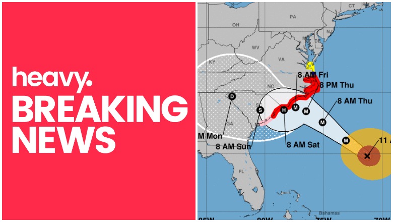
As of 11 a.m., Florence was located at 29.8 N and 71.3 W, about 485 miles (785 km) southeast of Wilmington, North Carolina, and about 520 miles (840 km) east-southeast of Myrtle Beach, South Carolina.
The storm is moving northwest or 305 degrees at 15 mph.
The National Hurricane Center noted the following at 11 a.m.: “Florence is now moving toward the northwest near 15 mph (24 km/h) and this general motion, accompanied by a gradual decrease in forward speed, is expected to through Saturday. On the forecast track, the center of Florence will move over the southwestern Atlantic Ocean between Bermuda and the Bahamas today, and approach the coast of North Carolina or South Carolina in the hurricane warning area on Thursday and Friday and move slowly near the coastline through Saturday.”
Hurricane Florence’s Wind Strength, Pressure, & Rainfall
The storm’s maximum sustained winds as of 11 a.m. are 130 mph, NOAA noted. (That’s 215 km/hour.) NOAA notes: “Florence is a category 4 hurricane on the Saffir-Simpson Hurricane Wind Scale. Some strengthening is forecast through tonight. While some
weakening is expected to begin by late Thursday, Florence is still forecast to be an extremely dangerous major hurricane when it nears the U.S. coast on Friday.”
The storm’s minimum central pressure is 943 MB or 27.85 inches. The estimated eye diameter is 25 nm as of 5 p.m. Tuesday (the diameter of the eye was not updated at 11 a.m.)
Hurricane-force winds extend outward up to 70 miles from the center, and tropical storm force winds extend outward up to 175 miles from the center. Hurricane-force winds may reach the coast within the warning area by late Thursday or Friday (slightly earlier than previously predicted.) Tropical storm strength winds will be felt on Thursday.
Florence is expected to produce heavy and excessive rainfall, NOAA noted. In coastal North Carolina, this could be 20 to 30 inches, isolated up to 40 inches in some areas, which could lead to catastrophic flooding.
In South Carolina, western, and northern Carolina, rain could be 5 to 10 inches, isolated up to 20 inches. In the Appalachians and mid-Atlantic states, this could be 3 to 6 inches, isolated up to 12 inches.
Current Watches & Warnings
According to the National Hurricane Center, the following warnings and watches are in effect.
Hurricane Warning
- South Santee River, South Carolina to Duck, North Carolina
- Albermarle and Pamlico Sounds
According to NHC: “A Hurricane Warning means that hurricane conditions are expected somewhere within the warning area. A warning is typically issued 36 hours before the anticipated first occurrence of tropical-storm-force winds, conditions that make outside preparations difficult or dangerous. Preparations to protect life and property should be rushed to completion.”
Hurricane Watch
- Edisto Beach, South Carolina to South Santee River, South Carolina
According to NHC: “A Hurricane Watch means that hurricane conditions are possible within the watch area. A watch is typically issued 48 hours before the anticipated first occurrence of tropical-storm-force winds, conditions that make outside preparations difficult or dangerous.”
Tropical Storm Warning
- North of Duck, North Carolina to the North Carolina/Virginia border
Tropical Storm Watch
- North of the North Carolina/Virginia border to Cape Charles Light, Virginia
- Chesapeake Bay south of New Point Comfort
According to NHC: “A Tropical Storm Watch means that tropical storm conditions are possible within the watch area, generally within 48 hours.”
Storm Surge Warning
- South Santee River, South Carolina to Duck, North Carolina
- Albemarle and Pamlico Sounds, including the Neuse and Pamlico
Rivers
According to NHC: “A Storm Surge Warning means there is a danger of life-threatening inundation, from rising water moving inland from the coastline, during the next 36 hours in the indicated locations. For a depiction of areas at risk, please see the National Weather
Service Storm Surge Watch/Warning Graphic, available at hurricanes.gov. This is a life-threatening situation. Persons located within these areas should take all necessary actions to protect life and property from rising water and the potential for other dangerous conditions. Promptly follow evacuation and other instructions from local officials.”
Storm Surge Watch
- Edisto Beach, South Carolina to South Santee River, SC
- North of Duck, North Carolina, to the North Carolina/Virginia border
According to NHC: “A Storm Surge Watch means there is a possibility of life-threatening inundation, from rising water moving inland from the coastline, in the indicated locations during the next 48 hours.”
Additional watches and warnings may be issued, so stay tuned.
Additional Hurricane Discussions
The NOAA’s 11 a.m. update included some additional information worth noting.
“At this time, little change has been made to the NHC track forecast, which remains
very close to the aforementioned consensus aids through 72 hours. On the current forecast track, the center of Florence is expected to be near the coasts of southern North Carolina and northern South Carolina in 48 to 72 hours and then drift westward to west-
southwestward in weak steering flow.”
The NHC also discussed the storm’s expected strengthening and slight weakening:
“There is still a narrow window of opportunity for Florence to strengthen a little when the cyclone moves over the warmest SSTs and highest upper-ocean heat content while the shear will be the lowest between 0600-1200 UTC tomorrow morning. After that, decreasing ocean heat content along with the slowing forward speed of Florence should
cause at least some cold upwelling beneath the hurricane, which should induce a gradual weakening trend. Once Florence reaches the shallow coastal shelf waters in 72 h, land interaction and more significant upwelling are expected, further enhancing the weakening process.”
READ NEXT: Live radars to track Hurricane Florence