Getty No, Hurricane Florence is not Sharknado. It doesn't contain sharks.
If you’ve seen memes, photos of tweets that show Hurricane Florence bringing flying sharks along, don’t worry. It’s a hoax. In fact, the hoax has surfaced in other hurricanes, most notably during Hurricane Irma.
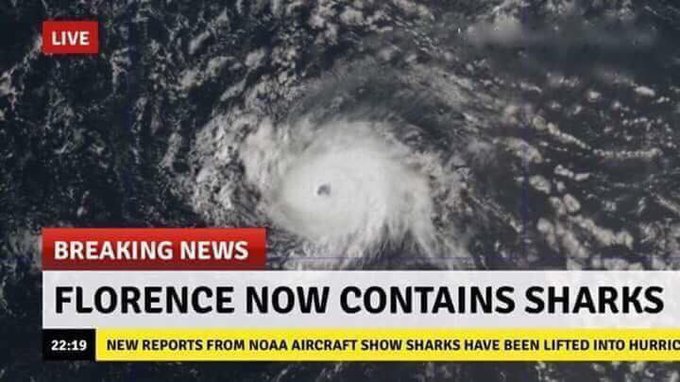
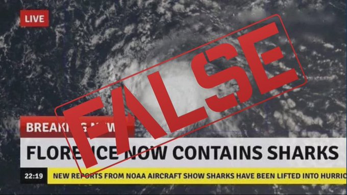
The premise appears to have derived from the Hollywood movie Sharknado and its sequels. Some people are sharing a photo of a supposed news broadcast revealing that “Florence now contains sharks.” However, it’s fake. That hasn’t actually been reported on the news.
Wait, what? Sharks have been lifted into the hurricane? Lol #HurricaneFlorence
According to the News and Observer, the image appears to derive from a meme creation site that anyone can use. The newspaper, perhaps simply stating the obvious, reported of Hurricane Florence: “What it is not expected to bring are sharks littered across the states, falling from the sky and terrorizing the population.”
Snopes.com has also debunked the Hurricane Florence contains sharks myth. The fact-checking site called the shark meme a “recycled fake.” Snopes noted that the meme blew up on social media during Hurricane Irma, which struck Florida. Snopes reports that the image was probably concocted on BreakYourOwnNews.com, a site where people can make fake news images. The picture of the hurricane is real, though, reported Snopes.
In case you still don’t believe it’s fake, NOAA confirmed as much to Metro, saying, “Hurricane Florence is a dangerous storm that is a threat to parts of the East Coast. Residents should be tracking factual information from NOAA’s National Weather Service at weather.gov and hurricanes.gov. Unlike in the science fiction movies, flying sharks are not one of the hazards with any hurricane.”
When the shark meme first showed up during Irma, Time Magazine quoted experts who said that sharks are sensitive to changes in barometric pressure so they swim out into deeper water during hurricanes – and away from the shoreline and you.
A viral photo making waves claims Hurricane Florence is lifting sharks out of the ocean making for a real-life Sharknado. Is it true? t.co/N8Lw13FqdL
On his September 11, 2018 talk show, Rush Limbaugh furthered the shark falsehood. A transcript of Rush Limbaugh’s show says, “The latest Hurricane Florence update: ‘New Reports from NOAA Aircraft Show Sharks Have Been Lifted into the Hurricane.’ So those of you in the target path in North Carolina, South Carolina? In addition to the pig manure, in addition to the slop, in addition to the floods, in addition to the cars rolling around on the waters in front of your house — in addition to the mudslides and the landslides — now you might end up with a shark in your front yard.”
“I’m telling you right now… (interruption) You think I’m making this up? This appeared somewhere. ‘Florence Now Contains Sharks.’ I’m telling you. You want to tell me this story is not true, that this is the one thing I cite…? Let me find the headline at the bottom of the Stack. ‘Hurricane Risks Including Toxic Sludge and Lagoons of Pig Manure.’ I’m telling you, they’re getting ready to call this Donald Trump’s Katrina! How many times did they…? You know, after George Bush had seen Katrina, how many other Katrinas did Bush have for the remainder of his term?”
Despite the lack of sharks, Hurricane Florence does bring serious dangers.
Here’s what you need to know:
Hurricane Florence Could Cause Life-Threatening Storm Surge & Rainfall
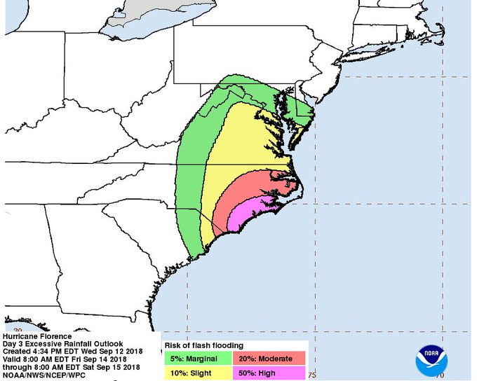
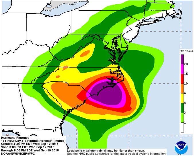
There is a high to moderate risk of flash flooding from #Florence across eastern North Carolina and extreme eastern South Carolina on Friday. @NWSWPC is forecasting more than 20″ of rain in some areas over the next week. t.co/krDhlpZ8LX
The 8 p.m. EDT Hurricane Florence update produced by the National Hurricane Center said that Florence has weakened “slightly as it continues toward the Carolina coastal areas…life-threatening storm surge and rainfall expected.”
SUMMARY OF 800 PM EDT…0000 UTC…INFORMATION
———————————————-
LOCATION…31.5N 73.2W
ABOUT 335 MI…540 KM SE OF WILMINGTON NORTH CAROLINA
ABOUT 370 MI…595 KM ESE OF MYRTLE BEACH SOUTH CAROLINA
MAXIMUM SUSTAINED WINDS…115 MPH…185 KM/H
PRESENT MOVEMENT…NW OR 315 DEGREES AT 16 MPH…26 KM/H
MINIMUM CENTRAL PRESSURE…956 MB…28.23 INCHES
SUMMARY OF WATCHES AND WARNINGS IN EFFECT:
A Storm Surge Warning is in effect for…
* South Santee River South Carolina to Duck North Carolina
* Albemarle and Pamlico Sounds, including the Neuse and Pamlico
Rivers
A Storm Surge Watch is in effect for…
* Edisto Beach South Carolina to South Santee River South Carolina
* North of Duck North Carolina to the North Carolina/Virginia border
A Hurricane Warning is in effect for…
* South Santee River South Carolina to Duck North Carolina
* Albemarle and Pamlico Sounds
A Hurricane Watch is in effect for…
* Edisto Beach South Carolina to South Santee River South Carolina
A Tropical Storm Warning is in effect for…
* North of Duck North Carolina to the North Carolina/Virginia border
A Tropical Storm Watch is in effect for…
* North of the North Carolina/Virginia border to Cape Charles Light
Virginia
* Chesapeake Bay south of New Point Comfort
The alert continues, “Interests elsewhere in the southeastern and mid-Atlantic states should monitor the progress of Florence. A Storm Surge Warning means there is a danger of life-threatening inundation, from rising water moving inland from the coastline, during the next 36 hours in the indicated locations. For a depiction of areas at risk, please see the National Weather Service Storm Surge Watch/Warning Graphic, available at hurricanes.gov. This is a life-threatening situation. Persons located within these areas should take all necessary actions to protect life and property from rising water and the potential for other dangerous conditions. Promptly follow evacuation and other instructions from local officials.”
“A Storm Surge Watch means there is a possibility of life-threatening inundation, from rising water moving inland from the coastline, in the indicated locations during the next 48 hours. A Hurricane Warning means that hurricane conditions are expected somewhere within the warning area. A warning is typically issued36 hours before the anticipated first occurrence of tropical-storm- force winds, conditions that make outside preparations difficult or dangerous. Preparations to protect life and property should be rushed to completion.”
“A Hurricane Watch means that hurricane conditions are possible within the watch area. A watch is typically issued 48 hours before the anticipated first occurrence of tropical-storm-force winds, conditions that make outside preparations difficult or dangerous.”
“A Tropical Storm Warning means that tropical storm conditions are expected somewhere within the warning area within 36 hours.”
“A Tropical Storm Watch means that tropical storm conditions are possible within the watch area, generally within 48 hours. For storm information specific to your area, including possible inland watches and warnings, please monitor products issued by your local National Weather Service forecast office.”
The outlook continued: “At 800 PM EDT (0000 UTC), the center of Hurricane Florence was located near latitude 31.5 North, longitude 73.2 West. Florence is moving toward the northwest near 16 mph (26 km/h), and this general motion, accompanied by a gradual decrease in forward speed, is expected to continue through Saturday. On the forecast track, the center of Florence will move over the southwestern Atlantic Ocean between Bermuda and the Bahamas tonight, and approach the coast of North Carolina or South Carolina in the hurricane warning area on Thursday and Friday, and move slowly near the coastline through Saturday.
Reports from an Air Force Reserve Hurricane Hunter aircraft indicate that maximum sustained winds have decreased to near 115 mph (185 km/h) with higher gusts. Florence is a category 3 hurricane on the Saffir-Simpson Hurricane Wind Scale. Some fluctuations in strength are possible through Thursday morning. Although slow weakening is expected to begin by late Thursday, Florence is forecast to be an extremely dangerous major hurricane when it nears the U.S. coast late Thursday and Friday.
Hurricane-force winds extend outward up to 70 miles (110 km) from the center and tropical-storm-force winds now extend outward up to 195 miles (315 km). The minimum central pressure extrapolated by the Hurricane Hunter aircraft is 956 mb (28.23 inches).”
HAZARDS AFFECTING LAND
———————-
“STORM SURGE: The combination of a dangerous storm surge and the tide will cause normally dry areas near the coast to be flooded by rising waters moving inland from the shoreline. The water has the potential to reach the following heights above ground if peak surge occurs at the time of high tide…
Cape Fear NC to Cape Lookout NC, including the Neuse, Pamlico,
Pungo, and Bay Rivers…9-13 ft
North Myrtle Beach SC to Cape Fear NC…6-9 ft
Cape Lookout NC to Ocracoke Inlet NC…6-9 ft
South Santee River SC to North Myrtle Beach SC…4-6 ft
Ocracoke Inlet NC to Salvo NC…4-6 ft
Salvo NC to North Carolina/Virginia Border…2-4 ft
Edisto Beach SC to South Santee River SC…2-4 ft
The deepest water will occur along the immediate coast in areas of onshore winds, where the surge will be accompanied by large and destructive waves. Surge-related flooding depends on the relative timing of the surge and the tidal cycle, and can vary greatly over short distances. For information specific to your area, please see products issued by your local National Weather Service forecast office.
RAINFALL: Florence is expected to produce heavy and excessive rainfall in the following areas…
Coastal North Carolina…20 to 30 inches, isolated 40 inches. This
rainfall would produce catastrophic flash flooding and significant
river flooding.
South Carolina, western and northern North Carolina…5 to 10
inches, isolated 20 inches.
Elsewhere in the Appalachians and Mid-Atlantic states…3 to 6
inches, isolated 12 inches.
WIND: Hurricane conditions are expected to reach the coast within the hurricane warning area late Thursday or Friday. Winds are expected to first reach tropical storm strength on Thursday, making outside preparations difficult or dangerous. Preparations to protect life and property should be rushed to completion.
TORNADOES: A few tornadoes are possible in eastern North Carolina beginning late Thursday morning.
SURF: Swells generated by Florence are affecting Bermuda, portions of the U.S. East Coast, and the northwestern and central Bahamas. These swells are likely to cause life-threatening surf and rip current conditions. Please consult products from your local weather office.”