NHS Hurricane Michael NOAA
Hurricane Michael is nearing the U.S. coast, and the National Hurricane Center is providing frequent updates about the storm’s movements as it approaches Florida. Here are the details from the latest update from the NOAA as of October 8 at 11 p.m. Eastern/10 p.m. Central. The next update will be at 4 a.m. Central, with an intermediate update at 1 a.m. You can read the full updates on the NOAA’s website here.
Hurricane Michael’s Location, Coordinates & Movement
NHS
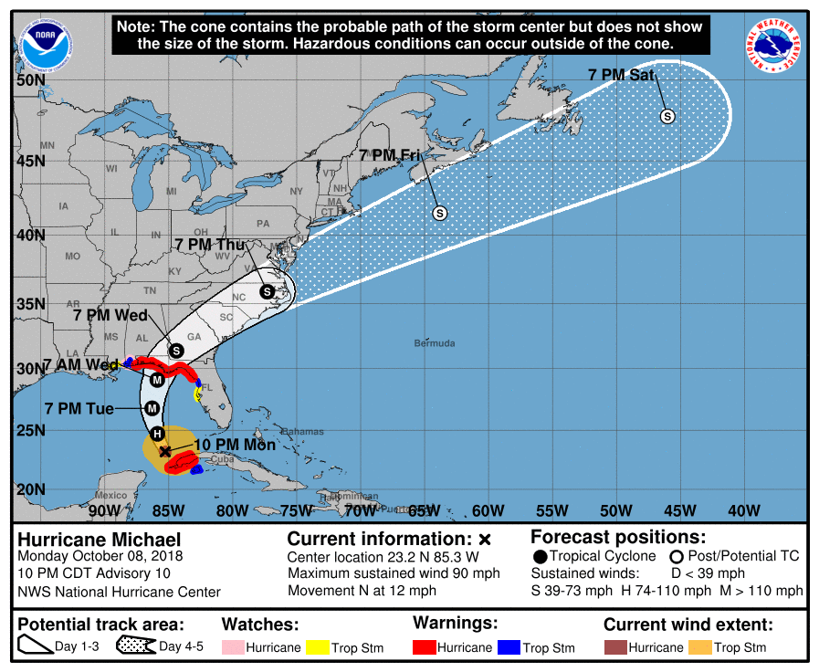
As of 10 p.m., Michael was located at 23.2 N, 85.3 W. The storm is about 485 miles south of Panama City, Florida and 450 miles south of Apalachicola, Florida. It’s moving North or 350 degrees at 12 mph.
The National Hurricane Center noted the following at 10 p.m.: “A northward to north-northwestward motion at a slightly faster forward speed is expected through Tuesday night, followed by a northeastward motion on Wednesday and Thursday. On the forecast track, the center of Michael will continue to move over the southeastern Gulf of Mexico tonight, then move across the eastern Gulf of Mexico Tuesday and Tuesday night. The center of Michael is expected to move inland over the Florida Panhandle or Florida Big Bend area on Wednesday, and then move northeastward across the southeastern United States Wednesday night and Thursday.”
Hurricane Michael’s Wind Strength, Pressure, & Rainfall
The storm’s maximum sustained winds are currently 90 mph. NOAA notes that there are higher gusts. “Steady to rapid strengthening is forecast during the next day or so, and Michael is expected to become a major hurricane by Tuesday night.”
The storm’s minimum central pressure is 970 MB or 28.65 inches.
Hurricane-force winds extend outward up to 35 miles from the center, and tropical storm force winds extend outward up to 175 miles.
Michael is expected to produce storm surges in normally dry areas near the coast. If peak surge is during high tide, the water could reach heights of 8-12 feet in Indian Pass, FL to Cedar Key, FL; 6-8 feet in Cedar Key, FL to Crystal River, FL; 6-9 feet in Okaloosa/Walton County Line, FL to Indian Pass, FL; 4-6 feet in Crystal River, FL to Anclote River, FL; 2-4 feet in Anclote River, FL to Anna Maria Island, FL (including Tampa Bay) and in the Alabama/Florida border to Okaloosa/Walton County Line, FL.
Michael could produce 4 to 8 inches in Western Cuba with isolated amounts of 12 inches; and the same in the Florida Panhandle and Big Bend, southeast Alabama, Georgia, and South Carolina. Other areas may see 2 to 4 inches with isolated amounts of up to 6 inches.
Current Watches & Warnings
According to the National Hurricane Center, the following warnings and watches are in effect.
Hurricane Warning
- Alabama/Florida border to Suwannee River, Florida
- The Cuban province of Pinar del Rio
According to NHC: “A Hurricane Warning means that hurricane conditions are expected somewhere within the warning area. A warning is typically issued 36 hours before the anticipated first occurrence of tropical-storm-force winds, conditions that make outside preparations difficult or dangerous. Preparations to protect life and property should be rushed to completion.”
Hurricane Watch
- Alabama/Florida border to the Mississippi/Alabama border
According to NHC: “A Hurricane Watch means that hurricane conditions are possible within the watch area. A watch is typically issued 48 hours before the anticipated first occurrence of tropical-storm-force winds, conditions that make outside preparations difficult or dangerous.”
Tropical Storm Warning
- Alabama/Florida border to the Mississippi/Alabama border
- Suwannee River, Florida to Chassahowitzka, Florida
- The Cuban province of the Isle of Youth
According to NHC: “A Tropical Storm Warning means that the tropical storm conditions are expected somewhere within the warning area within 36 hours.”
Tropical Storm Watch
- Chassahowitzka to Anna Maria Island, Florida including Tampa Bay
- Mississippi/Alabama border to the Mouth of the Pearl River
According to NHC: “A Tropical Storm Watch means that tropical storm conditions are possible within the watch area, generally within 48 hours.”
Storm Surge Warning
- Okaloosa/Walton County Line Florida to Anclote River Florida
According to NHC: “A Storm Surge Warning means there is a danger of life-threatening inundation, from rising water moving inland from the coastline, during the next 36 hours in the indicated locations. For a depiction of areas at risk, please see the National Weather Service Storm Surge Watch/Warning Graphic, available at hurricanes.gov. This is a life-threatening situation. Persons located within these areas should take all necessary actions to protect life and property from rising water and the potential for other dangerous conditions. Promptly follow evacuation and other instructions from local officials.”
Storm Surge Watch
- Anclote River Florida to Anna Maria Island Florida, including
Tampa Bay - Alabama/Florida border to Okaloosa/Walton County Line Florida
According to NHC: “A Storm Surge Watch means there is a possibility of life-threatening inundation, from rising water moving inland from the coastline, in the indicated locations during the next 48 hours.”
Additional watches and warnings may be issued, so stay tuned.
Additional Hurricane Discussions
The NOAA has also noted the following: “Data from NOAA and Air Force Reserve hurricane hunter aircraft this evening indicate that Michael has continued to strengthen…despite westerly vertical shear of about 20 kt, which is most unusual…”
“The steering flow pattern isn’t forecast to change much, if at all, for the next 36-48 hours, with Michael expected to remain caught between a deep-layer ridge centered off of the U.S. east coast and a highly amplitude mid-latitude trough over the U.S. Plains states and northern Mexico. The combined deep-layer southerly flow should keep the hurricane moving northward to north-northwestward for the next 36 hours or so. Shortly thereafter and just prior to landfall, the approaching mid-latitude trough is expected to turn Michael toward the north-northeast or northeast. By 48 hours and beyond, significant acceleration toward the northeast ahead of the trough is forecast to continue through the 120-h period, with Michael emerging off of the U.S. mid-Atlantic coast around 96 hours. The new NHC forecast track was nudged slightly to the east of the previous track through 36 h, based on the more eastward initial position and a forward motion that is still to the right or east of short term motion in the model guidance, but is still near the consensus models TVCN, TVCX, and NOAA-HCCA. By 48 hours and beyond, the official track is close to the previous advisory track,” NOAA notes.