NOAA Hurricane Michael Path
Hurricane Michael is nearing the U.S. coast, and the National Hurricane Center is providing frequent updates about the storm’s movements as it approaches Florida. Here are the details from the latest update from the NOAA as of October 9 at 4 p.m. The next update will be at 11 p.m. with an intermediate update at 7 p.m. You can read the full updates on the NOAA’s website here.
Hurricane Michael’s Location, Coordinates & Movement on October 9 at 4 p.m.
NOAA
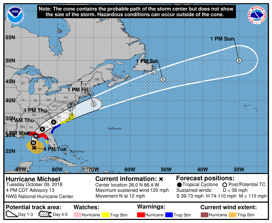
As of 4 p.m., Michael was located at 26.0 N, 86.4 W, about 295 miles S of Panama City, Florida and 270 miles SSW of Apalachicola, Florida. It’s moving N or 350 degrees at 12 mph.
The National Hurricane Center noted the following at 4 p.m.: “Michael is still moving north-northwestward to northward at about 10 kt. The hurricane should turn due northward this evening, then northeastward on Wednesday as a trough moves into the central United States. Michael should become embedded within the westerlies in 48 to 72 hours, and then accelerate northeastward to east-northeastward over the western and central-north Atlantic over the weekend.”
“A northward motion is expected through tonight, followed by a northeastward motion on Wednesday and Thursday. On the forecast track, the center of Michael will move across the eastern Gulf of Mexico through tonight. The center of Michael is then expected to move inland over the Florida Panhandle or Florida Big Bend area on Wednesday, and then move northeastward across the southeastern United States Wednesday night and Thursday, and move off the Mid-Atlantic coast away from the United States on Friday.”
Hurricane Michael’s Wind Strength, Pressure, & Rainfall
The storm’s maximum sustained winds are currently 120 mph, making Michael a Category 3 Hurricane. NOAA notes that there are higher gusts.
“Maximum sustained winds have increased to near 120 mph (195 km/h) with higher gusts. Michael is a category 3 hurricane on the Saffir-Simpson Hurricane Wind Scale. Some additional strengthening is expected, and Michael is forecast to be a major hurricane at landfall in Florida. Weakening is expected after landfall as Michael moves through the southeastern United States.”
The storm’s minimum central pressure is 957 MB or 28.26 inches.
Hurricane-force winds extend outward up to 45 miles from the center, and tropical storm force winds extend outward up to 175 miles.
Michael is expected to produce storm surges in normally dry areas near the coast. If peak surge is during high tide, the water could reach heights of 9-13 feet in Mexico, Beach FL to Keaton Beach, FL; 6-9 feet in Okaloosa/Walton County Line, FL to Mexico Beach, FL; 6-9 feet in Keaton Beach, FL to Cedar Key, FL; 4-6 feet in Cedar Key, FL Chassahowitzka, FL; and 2-4 feet in Chassahowitzka to Anna Maria Island, FL (including Tampa Bay) and Alabama/Florida border to Okaloosa/Walton County Line, Florida.
Michael could produce 4 to 8 inches of rain (with isolated maximums to 12 inches) in the Florida Panhandle and Big Bend, southeast Alabama, and parts of southwest and central Georgia. The remainder of Georgia, the Carolinas, and southern Virginia could see 3 to 6 inches with isolated maximums up to 8 inches. Other areas could see 1 to 3 inches.
Current Watches & Warnings
According to the National Hurricane Center, the following warnings and watches are in effect.
Hurricane Warning
- Alabama/Florida border to Suwannee River, Florida
According to NHC: “A Hurricane Warning means that hurricane conditions are expected somewhere within the warning area. A warning is typically issued 36 hours before the anticipated first occurrence of tropical-storm-force winds, conditions that make outside preparations difficult or dangerous. Preparations to protect life and property should be rushed to completion.”
Hurricane Watch
- Alabama/Florida border to the Mississippi/Alabama border
According to NHC: “A Hurricane Watch means that hurricane conditions are possible within the watch area. A watch is typically issued 48 hours before the anticipated first occurrence of tropical-storm-force winds, conditions that make outside preparations difficult or dangerous.”
Tropical Storm Warning
- Alabama/Florida border to the Mississippi/Alabama border
- Suwannee River, Florida to Chassahowitzka, Florida
- Fernandina Beach, Florida to South Santee River, South Carolina
According to NHC: “A Tropical Storm Warning means that the tropical storm conditions are expected somewhere within the warning area within 36 hours.”
Tropical Storm Watch
- Chassahowitzka to Anna Maria Island, Florida including Tampa Bay
- Mississippi/Alabama border to the Mouth of the Pearl River
- South Santee River, South Carolina to Duck North, Carolina
- Pamlico and Albermarle Sounds
According to NHC: “A Tropical Storm Watch means that tropical storm conditions are possible within the watch area, generally within 48 hours.”
Storm Surge Warning
- Okaloosa/Walton County Line Florida to Anclote River Florida
According to NHC: “A Storm Surge Warning means there is a danger of life-threatening inundation, from rising water moving inland from the coastline, during the next 36 hours in the indicated locations. For a depiction of areas at risk, please see the National Weather Service Storm Surge Watch/Warning Graphic, available at hurricanes.gov. This is a life-threatening situation. Persons located within these areas should take all necessary actions to protect life and property from rising water and the potential for other dangerous conditions. Promptly follow evacuation and other instructions from local officials.”
Storm Surge Watch
- Anclote River Florida to Anna Maria Island Florida, including
Tampa Bay - Alabama/Florida border to Okaloosa/Walton County Line Florida
According to NHC: “A Storm Surge Watch means there is a possibility of life-threatening inundation, from rising water moving inland from the coastline, in the indicated locations during the next 48 hours.”
Additional watches and warnings may be issued, so stay tuned.
Additional Hurricane Discussions
The NOAA has also noted the following: “The eye of Michael became very distinct in both visible and infrared satellite pictures early this afternoon, but has been a little more cloud filled since that time. Very deep convection has continue to develop over the southeastern and eastern portion of the eyewall and rotate around the north and west sides…The environment ahead of Michael is expected to remain conducive for additional strengthening during the next 12 to 18 hours. There may be some increase in southwesterly shear as the hurricane nears the Gulf Coast, but it is not likely to result in a significant decrease in intensity before landfall.”