
Getty A Cal Fire firefighter sprays water on a home next to a burning home as the Camp Fire moves through the area.
The Camp Fire in Paradise, California in Butte County was just reported on Thursday, November 8 and grew rapidly to 8,000 acres before then jumping to 20,000 acres. By Saturday, November 10, the devastating fire was 100,000 acres in size. Read on to see interactive maps of the fire along with the latest details on the fire’s size, containment, evacuations, and a map of evacuation zones.
Camp Fire Maps
First, take a look at several general interactive maps of fires in California. For these, you can zoom in closer to see the Camp Fire specifically. On the map below, maintained by CAL FIRE, the Camp Fire can be found if you zoom in halfway between Redding and Red Bluff. Depending on your browser, you may need to zoom into the map to see the details.
The next map below shows affected areas with road closures from the fire. Depending on your browser, you may need to zoom into the map to see the details.
Below is another active fire map from Google’s Crisis Map. Zoom in to see the Camp Fire.
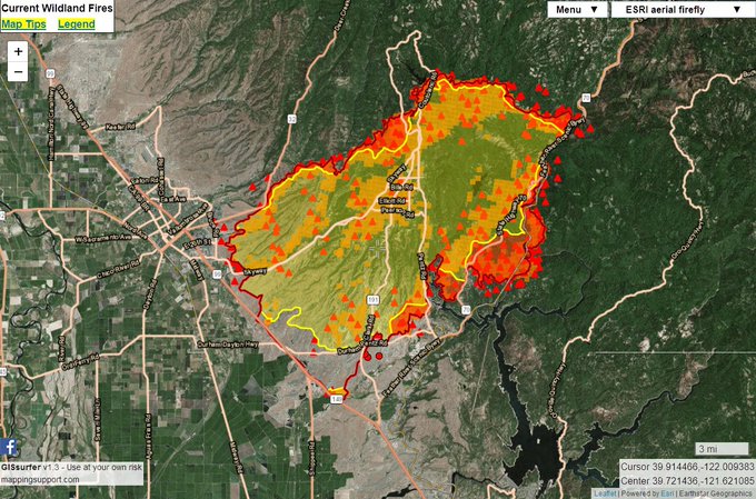
These aren’t your only interactive map options for the Camp Fire. Mapping Support is tracking the fire closely. Here is the latest interactive Camp Fire map from Mapping Support. Click on the link in the tweet below to see the map:
Saturday 11/10 #CampFire 109,502 acres per 7:02pm infrared flight yesterday + analysis by fire staff. Fire weather forecast + other GIS layers. Need help using the map? Click “Map tips” upper left corner. Open #GISsurfer map: t.co/NWrJise6yk #GeoSpatial
Here is another map:
#CampFire a few more areas of concerns. Berry Creek I hear is under mandatory evacs. And Butte Creek Canyon is a concern because they don’t know where the fire is or what it’s doing due to smoke conditions.

The fire has not yet been added to Inciweb.
Camp Fire Size, Containment, & Road Closures
The fire began at 6:30 a.m. Thursday, November 8 near Camp Creek Road close to Pulga, Oroville MR reported. In a few hours, it had grown to 5,000 acres and 0 percent containment, according to CAL FIRE. Sustained winds of 30 to 35 mph weren’t helping. By 1 p.m. Pacific, KTVU had reported that the fire had grown to 8,000 acres. But by 8:15 p.m., the fire had grown to 20,000 acres.
Things only got worse on Friday, November 9 when the fire was estimated to be 70,000 acres and 5 percent contained.
Now the fire has grown to 100,000 acres, according to CAL FIRE. (Some sources place it at slightly greater than this.) But containment has also increased and is at 20 percent.
At least 15,000 structures are threatened and 6,453 residences and 260 commercial structures have been destroyed from this fire, according to CAL FIRE. Strong northeast winds are expected to return this evening, and low humidities and dry fuel are still helping the fire grow.
CAL FIRE wrote on Saturday: “The fire will continue to burn to the NW impacting the communities of Magalia and Paradise Pines. Fire crews will continue to conduct structure defense and perimeter control. The community of Stirling City and Paradise Pines is still threatened. The fire is holding to the southwest near Chico and South at Hwy 99 and Hwy 149. The fire will continue to burn to the SW toward Big Bend, Berry Creek and threatening the City of Orville. The expected strong NE wind event has the potential to drive fire across Lake Oroville threatening the City of Oroville. Extreme fire behavior with dangerous rates of spread are expected. Resources will be prepositioned in preidentified locations in anticipation of the wind event. Crews continued tactical patrols in the communities of Paradise, Concow, and Magalia.”
CAL FIRE listed the following road closures on Saturday: “SR-70 W/B at SR-89 closed. SR-149 N/B at SR-70 is closed. Pentz Rd W/B at SR-70 is closed. Wheelock Rd W/B at SR-70 is closed. SR-191 W/B at SR-70 is closed. SR-70 N/B at Garden Rd. is closed. SR-99 N/B at Shippee Rd. is closed. Durham Pentz Rd. E/B at SR-99 is closed. Neal Rd. at SR-99 is closed. Skyway is impassable at Lake Ridge. SR-99 S/B at Estates Dr. is closed. SR-99 S/B at Southgate Ln. is closed. SR-149 S/B at SR-99 is closed. E/B Skyway at Honey Run is closed. E/B Skyway at Bruce is closed. Humboldt Rd. at Stilson Canyon is closed. SR-32 E/B at Yosemite is closed. SR-32 W/B at SR-36 In Tehema County is closed Cherokee Rd N/B at La Colina Dr. is closed. Direction of travel impacted by road closures will be updated as the information is obtained.”
For information on road closures visit, http://www.dot.ca.gov/hq/roadinfo/Hourly.
Camp Fire Evacuations & Evacuation Zones
Evacuations have been ordered for the fire in multiple regions. These include, but may not be limited to, the following evacuation orders, according to CAL FIRE as of 7 a.m. on Saturday, November 10:
- Established for Paradise, Magalia, Concow, Butte Creek Canyon, and Butte Valley
- Powellton zone
- Lovelock zone
- Humbug zone
- Stirling zone
- North Coutelenc zone
- North fir haven zone
- Nimshew zone
- Carnegie/colter zone
- South Firhaven zone
- South Coutelenc zone
- North pines zone
- South pines zone
- Old Magalia zone
- Lower Pentz zone
- Morgan ridge zone
- Lower Clark zone
- Highway 32 at Nopel South all the way to Chico city limits
- Butte creek road
- Centerville road
- Concow
- Pulga
- Yankee Hill
- Skyway from lower paradise to the Chico city limits
- Morgan ridge
- Highway 70 from Pulga to West branch
- Feather river bridge
- All of Clark Road and all of Pentz road, south to highway 70, everything west to highway 99 and south to highway 149 including all of Butte Valley
- Shippee Road from Highway 149 to Highway 99
- Cherokee Road to Highway 70 to Lake Oroville south to Table Mountain Blvd.
- A newer evacuation order was issued on Saturday for East Bound Hwy 162/Oro Quincy Hwy at Forbestown Rd east to Mountain House/4 Mile Ridge Road, including the communities of Berry Creek, Brush Creek, Mountain House, and Bloomer Hill.
Here is a map of the evacuation zones in Paradise, in case you’re not sure where your zone is. Click here to look up your zone by address. Or see a larger version of the Paradise Evacuation Zone map here.
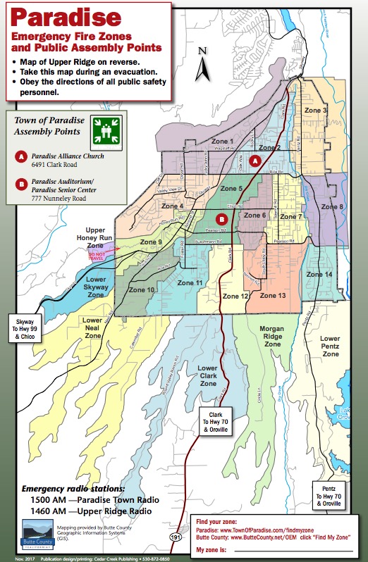
Town of ParadiseParadise Evacuation Zones
Here’s a look at the Upper Ridge evacuation zone map. You can see a larger version here.
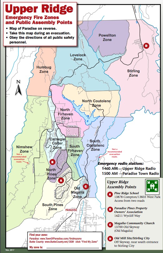
Town of Paradise
The town of Paradise provides this map which explains how one-way evacuations work in the town during emergency situations. You can view the full emergency brochure here.
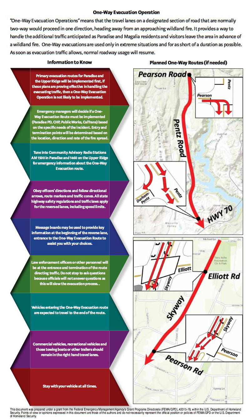
Town of ParadiseOne way evacuation page from Paradise.
If you’re not sure if you’re in an evacuation area, call 911.
Here are some evacuation centers in the area:
- Butte County: Church of the Nazarene, 2238 Monte Vista Ave Oroville Ca 95966
- Butte County: Neighborhood Church, 2801 Notre Dame Blvd Chico, Ca.95928
- Butte County: Chico Elks Club (1705 Manzanita, Chico)
- Glenn County: Glenn County Fairgrounds, 221 E. Yolo Street, Orland, CA 95963
- Yuba County: Yuba/Sutter County Fairgrounds, 442 Franklin Street, Yuba City, CA 95991
- Plumas County: Veterans Memorial Hall, 22 Gay Street, Chester, CA
Here are some animal shelters in the area:
- Small animals: County Hospital at 2279 Del Oro and Mono, Suite E (also called the Del Oro Old County Hospital)
- Large animals: Butte County Fairgrounds at 199 E Hazel St. in Gridley, CA
- Small animals: Chico Municipal Airport at 150 Airpark Blvd. in Chico, CA
If you’re wanting to know what roads are closed, Caltrans HQ has the answer for you:
Camp Fire evacuations can change rapidly. Follow the Butte County Sheriff’s Twitter account and the Butte County’s Twitter for the latest updates. Emergency radio stations for the Paradise area include 1500 AM (Paradise Town Radio) and 1460 AM (Upper Ridge Radio.)
This is a developing story.