Getty Woolsey Fire Map
The Woolsey Fire just started Thursday, November 8, and now it’s more than 83,000 acres and one of the largest fires in California, leaving extensive damage as it burns in Malibu and Ventura County, causing thousands to evacuate. The fire has grown so fast because of gusty winds. Here are more details about the fire and evacuations in Ventura County and Los Angeles areas, including Malibu, as of Sunday, November 11.
Woolsey Fire Map, Size & Containment
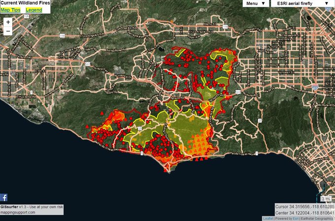
Sunday 11/11 #WoolseyFire 96,030 acres per overnight infrared flight + analysis by fire staff. To turn other GIS layers on/off, click the basemap button (next to Menu button) and then look under the “Overlay” heading. Open #GISsurfer map: t.co/NMIHljWLxT #GeoSpatial
The Woolsey Fire is now 83,275 acres, according to the latest update by CAL FIRE on Sunday, November 11 at 7 a.m. The fire is 10 percent contained, which is a small increase from Saturday. (An earlier version of this story had an incorrect higher acreage count due to a glitch in the text.)
The Woolsey Fire began Thursday afternoon as a “smaller” fire in Simi Valley near the Rocketdyne facility in Santa Susana Pass, ABC 7 reported. It was close enough that you could see it near the Hill Fire in aerial photos. But now the fire has grown because of strong winds in Santa Ana. Here’s a map of the Woolsey and Hill Fires.
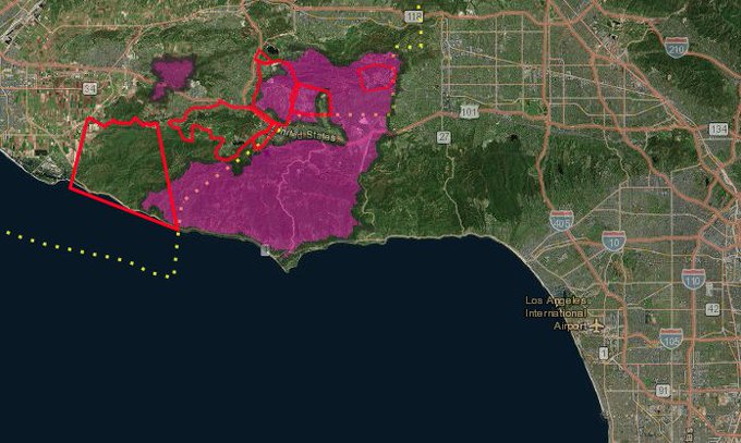
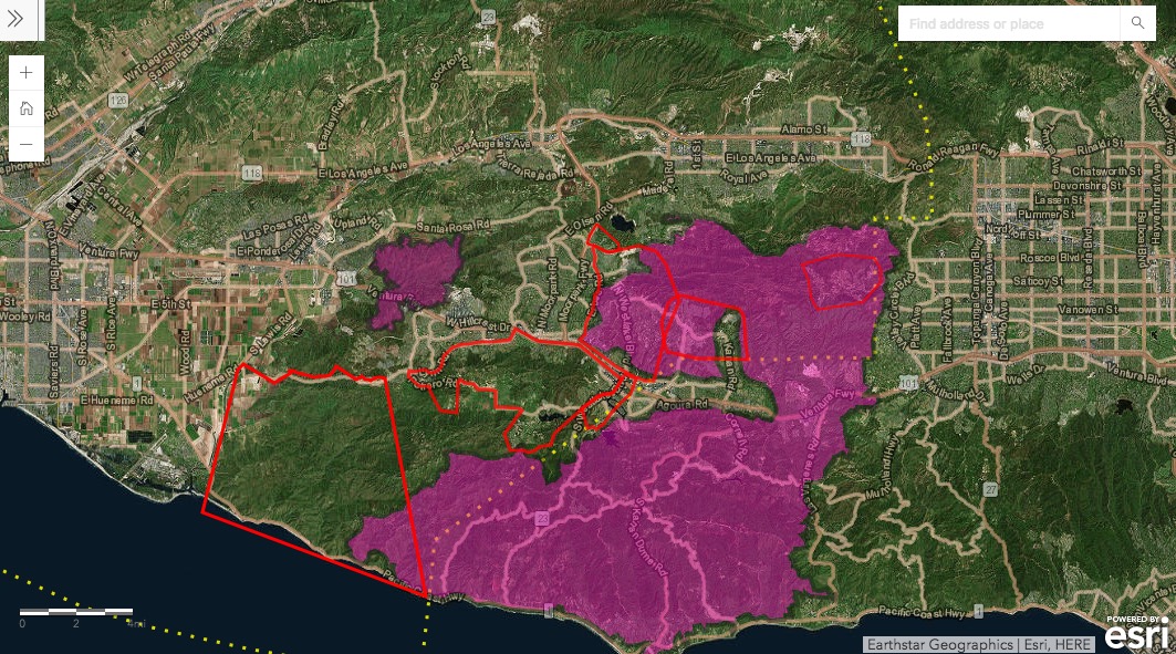
This map from Ventura County gives you an idea of the size of the #WoolseyFire and #HillFire in Southern California – the purple area is the approximate fire perimeter, more than 83,000 acres burnt so far @KTLA
Here’s an interactive map showing the southern California wildfires:
And another map from the LAFD can be seen here.
Here is a video with the latest Woolsey press conference (you may need to click on the link in the tweet to see the press conference):
#WoolseyFire and HillFire 11/11/18 9:30 press briefing

CAL FIRE noted on Sunday morning: “Due to extreme fire behavior, firefighting efforts have been focused, and will remain focused, on the protection of life, and structures. Favorable overnight weather conditions contributed to minimal fire growth, which allowed crews to reinforce containment lines. Crews will continue to battle steep terrain, limited access, and extreme fire behavior. Moderate to strong Santa Ana winds will continue across the area throughout the day, peaking tonight into tomorrow morning.”
Woolsey Fire Evacuation Details
More than 200,000 residents and 75,000 homes, including in Malibu, are now under mandatory evacuations from the Woolsey and Hill fires. According to CAL FIRE, there have been three firefighter injuries and two civilian injuries/fatalities from the fire. About 57,000 structures are threatened and 177 structures have been destroyed.
The map below shows where evacuations have been issued and where the Woolsey and Hill fires are located. The map was shared by Los Angeles Daily News on November 9. It’s unclear how quickly the map is being updated, so keep that in mind. Depending on your browser, you may need to zoom in to see the relevant area.
Here is another unofficial map of the Woolsey Fire evacuations. It’s also unclear how quickly this map is being updated. Depending on your browser, you may need to zoom in to see the relevant area.
Here’s a list of some of the areas that have been issued evacuation orders, including Los Angeles County, Malibu, and Ventura County.
- All of the city of Malibu remains under evacuation orders. (Google)
- Also in Malibu, areas south of 101 Freeway from Ventura County border to Las Virgines/Malibu Canyon, southward to the ocean (LA County)
- Hidden Hills- entire community – residents urged to take Valley Circle Boulevard towards Chatsworth (LA County)
- Calabasas – all residences Parkway Calabasas, including The Oaks, Vista Point, Westridge, Calabasas Hills, Calabasas Park Estates (LA County)
- Agoura Hills (LA County)
- Monte Nido/ Topanga – entire community (LA County)
- Liberty Canyon west to Decker Canyon and south all the way to Pacific Coast Highway
- Las Virgenes/Malibu Canyon east to Decker Canyon and west to Malibu/PCH (LA County)
- Oak Park-entire community (LA County)
- Bell Canyon- entire community (LA County)
- South of Bard Lake, east of Highway 23 (LA County)
- South of Highway 101, east of Reino Road, north of Potrero Road, East to the Los Angeles/Ventura County Line (LA County)
- Westlake Villag (LA County)
- West Hills, west of Valley Circle Boulevard with border to the north at Roscoe Boulevard and to the south at Vanowen Street. (LA County)
- Thousand Oaks – Thousand Oaks Boulevard north to Sunset Hills, from Oak Park west to Highway 23 (LA County)
- West of Highway 23, south of Olsen Road, north to Pederson Road (LA County)
- Bell Canyon – Entire Community (CAL FIRE)
- Oak Park – Entire Community (CAL FIRE)
- Thousand Oaks – T.O. Blvd north to Sunset Hills, from Oak Park west to Highway 23 (CAL FIRE)
- West of Highway 23 – south of E. Olsen Road, north of Pederson Rd. South of Bard Lake, east of Highway 23 (CAL FIRE)
- South of Highway 101, east of Reino Rd., north of Potrero Rd., east to the L.A./Ventura County line (CAL FIRE)
- Point Mugu Naval Base (Hill Fire)
- South Coast – All areas outlined on map below (Hill Fire)
- Thousand Oaks – All areas outlined on map below (Woolsey Fire)
You can see a map of mandatory and voluntary evacuation areas for LA County only here.
You can see exactly where your address falls in Ventura County evacuations by scrolling down to the map on this page. A screenshot of the map is below. Purple shows the fire’s perimeter, red indicates mandatory evacuation areas in Ventura County, and orange indicates voluntary evacuation areas.
VCEmergency.comEvacuations in Ventura County
The following areas that were previously evacuated in Ventura County are no longer evacuated:
- Camarillo Springs (Hill Fire)
- California State University Channel Islands (Hill Fire)
- Dos Vientos (Hill Fire)
- Vallecito Trailer Park (Hill Fire)
- Newbury Park – South of Highway 101 to Lynn Road, between Reino Road and Lynn Road (Woolsey Fire)
- Thousand Oaks – East of Highway 23 to Erbes Road and north from Thousand Oaks Blvd to Sunset Hills Blvd (Woolsey Fire)
- Thousand Oaks – West of Highway 23 between East Olsen Road and Sunset Hills Blvd (Woolsey Fire)
- Simi Valley – Long Canyon, Bridal Path, Wood Ranch (Woolsey Fire)
Remember, evacuation details can change quickly. Contact your local authorities for the latest updates.
Evacuation Centers
Evacuation centers for the Hill and the Woolsey Fire include:
- Palisades High School at 15777 Bowdoin St., Pacific Palisades, in California is the closest evacuation center for Malibu residents, LASD reported.
- Rancho Santa Susana Recreation Center at 5005 Unit C Los Angeles Ave. in Simi Valley is an evacuation center, but it is not accepting animals. (@VCFD_PIO). Has N95 masks.
- Borchard Community Center is a Red Cross Shelter for Woolsey and the Hill Fire (190 Reino Road in Newbury Park) (accepting small animals, N-95 masks available)
- Camarillo Community Center at 1605 Weast Burnley St. in Camarillo, CA is a Red Cross shelter. This shelter is accepting small animals and has N-95 masks available.
- Thousand Oaks High School – 2323 N. Moorpark Rd. in Thousand Oaks, CA
- Thousand Oaks Teen Center
- Goebel Senior Adult Center
- Taft Charter High School (at capacity)
Here is a list of shelters accepting animals:
- The Humane Society of Ventura County is accepting dogs, cats, horses, and other domesticated animals. 402 Bryant St., Ojai, CA. 805-646-6505.
- Hansen Dam was accepting large animals. (at capacity)
- Zuma Beach Parking Lot is also accepting large animals, Malibu Times reported.
- Pierce College was accepting large animals but is now full. (at capacity)
- Ventura County Fair Grounds – (805) 388-425 (at capacity)
- Ventura County Animal Shelter – Ventura County Animal Services (805) 388-4258
- Camarillo Community Center is an evacuation center and is accepting small animals
- Borchard Community Center is an evacuation center and is accepting small animals
- Simi Valley Animal Shelter – 670 W. Los Angeles Ave. in Simi Valley. 805-388-4341.
- Earl Warren Show Grounds – 3400 Calle Real, Santa Barbara. Check-in at Gate C off Calle Real
- Animals in crates are accepted at all Red Cross shelters except Palisades Charter (per LA County)
- If you need assistance with large animals, call 805-388-4258.
Parts of the Ventura 101 freeway remain closed.
Road Closures & Shelters Map
If you would like to see a map that includes road closures and fire perimeters, along with shelter locations, here is a Google Crisis Map below. Depending on your browser, you may need to zoom in to see the relevant area.
You can also use the Red Cross Emergency App to see shelters:
Check out the live map in the @RedCross Emergency App for the latest shelter locations & disaster updates related to the #WoolseyFire. 8 shelters currently open, between #VenturaCounty and #LACounty. t.co/kDMOrBQMAA
How to Stay Updated on the Fire & Evacuations
Remember, you can get emergency alerts about Ventura County by texting VCALERT to 313131 or visiting vcalert.org. Other sources for staying updated on this fire include @CHPWestValley and @VCFD_PIO.
In the Malibu region, visit www.MalibuCity.org and scroll down to Alert Center and select “Emergencies” to sign up for Malibu Emergency Alerts by text or email. Sign up for City of Malibu Disaster Notifications at www.MalibuCity.org/DisasterNotifications.
For the latest updates on LA County evacuations, check here.
This is a developing story.