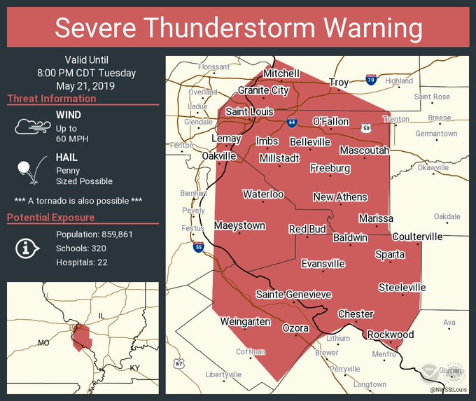
Severe Thunderstorm Warning continues for Saint Louis MO, Belleville IL, Oakville MO until 8:00 PM CDT
The St. Louis area was experiencing severe weather on the evening of May 21, 2019 with the frightening but now likely expired possibility of tornadoes. “Funnel clouds have been sited (sic) near Lambert airport with this storm. Seek shelter immediately!!” the National Weather Service’s St. Louis office wrote just after 7 p.m. A tornado warning was issued for the City of St. Louis and surrounding areas. However, at 7:19 p.m, the office declared: “The City of St. Louis is no longer under a tornado warning [7:18 pm] #mowx.”
All watches and warnings for the City of St. Louis have expired. Be safe if there is damage near you. Damage may be reported to @stlcsb
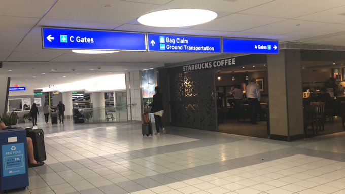
Although flights were grounded at the St. Louis airport, they have now resumed. “Severe storm line has passed. @FAANews has ended ground stop. Flights are resuming. #stlairport has issued all clear to resume normal operations,” the airport wrote. The danger had shifted largely to Illinois.
“Severe Thunderstorm Warning continues for Saint Louis MO, Belleville IL, Oakville MO until 8:00 PM CDT,” the office continued.
St.Louis Blues is still playing a hockey game while under a tornado warning not a smart idea. Anyways let’s go Blues. One more win away from the championship series! #LGB

St. Louis Emergency Management wrote, “The tornado warning has now been canceled for the City of St. Louis. We do remain under a severe thunderstorm warning until 8 p.m. and a tornado watch until 10 p.m. (Message time 7:22 p.m. 5/21/19).”
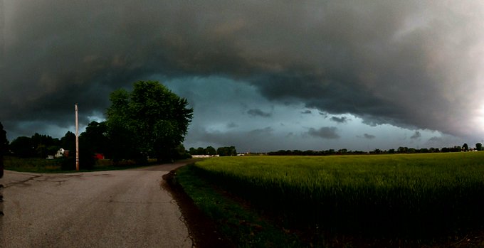
People posted videos and photos to social media showing the bad weather. You can see them throughout this article.
@ThomasPatrickWx Cahokia, Illinois at 7:03pmCT right as rain started.
You can get the latest weather updates via the National Weather Service’s St. Louis office on Twitter.
The page is here. You can get the latest weather updates, including forecast and radar, on the St. Louis, Missouri National Weather Service page here.
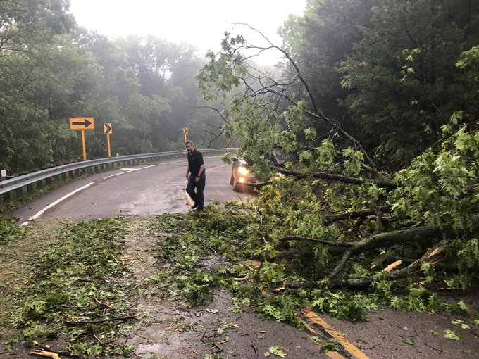
Trees were down near Augusta.
On 94 south of Augusta, multiple trees down across the road #stows
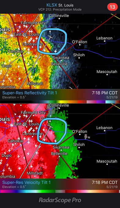
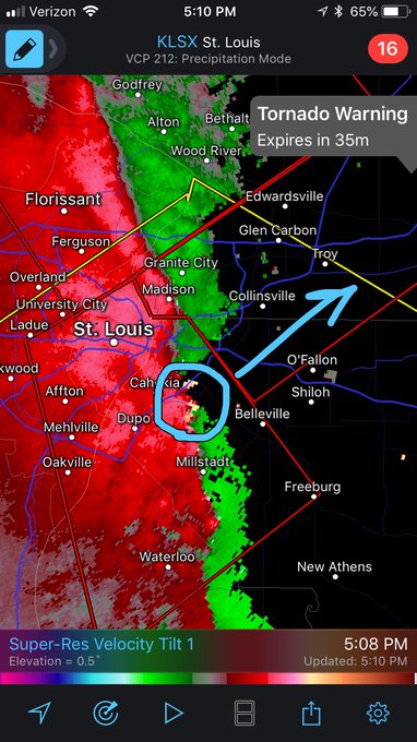
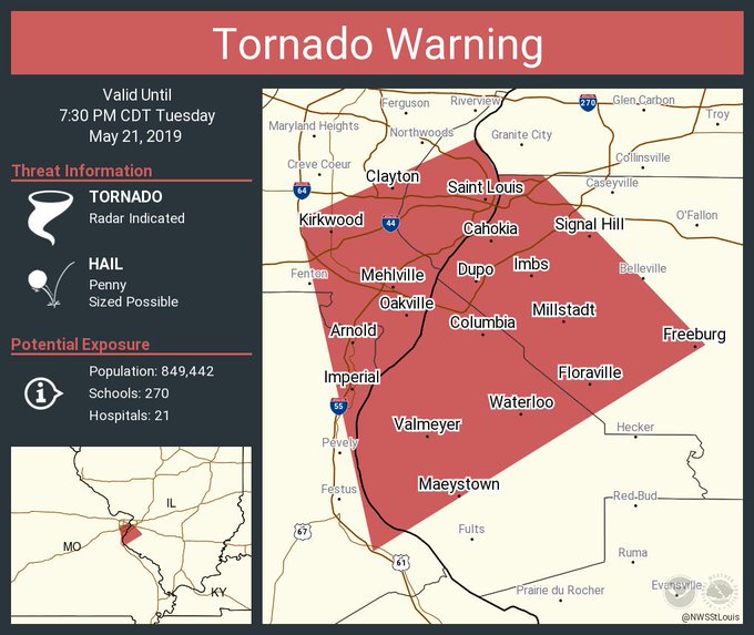
The tornado-producing weather was clustered around Cahokia, Illinois.
The most suspect area for tornado development near St. Louis is over Cahokia, IL. Widespread straight line winds of 60mph+ is likely being felt across the metro.
Just before 7 p.m., the City of St. Louis Emergency Management wrote, “Please shelter now. Stay tuned to local media and wait until the storm passes before leaving your shelter.” The situation in the City of St. Louis escalated quickly from a severe thunderstorm warning to a tornado warning. Tornado warning sirens were reportedly going off in downtown St. Louis:
Here’s another view:
Sirens sounding in north St. Louis County. I am at I-270 and Lilac. #stlwx @NWSStLouis
Arrivals & Departures Were Stopped at the St. Louis Airport But They’ve Restarted
Severe storm line has passed. @FAANews has ended ground stop. Flights are resuming. #stlairport has issued all clear to resume normal operations.
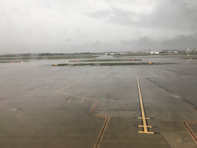
The airport was temporarily closed. But word then came that flights have resumed and the ground stop was lifted.
“The @FAANews has stopped all arrivals and departures at the #stlairport due to the extreme weather in the region,” the airport wrote. If you’re flying, the airport says, check your flight status with your airline here.
KLSX – Super-Res Velocity Tilt 1 7:01 PM CDT #mowx Tornado warnings continue in and around St. Louis as rotating line of thunderstorms continues to impact the area there have been reports of funnel clouds in rotation take cover
One reporter wrote that the all clear had been given at the airport.
“All Clear” given at St. Louis airport. @ksdknews @JustinaCoronel
Just before 7 p.m., the NWS reported that there were tornado warnings for “Saint Louis MO, Oakville MO, University City MO until 7:30 PM CDT.”
I have lot of friends in St. Louis and I hope everyone is taking cover right now as Tornado Warnings are in effect!

Nine minutes before that, the NWS tweeted: “Tornado Warning continues for Saint Charles MO, Florissant MO, Maryland Heights MO until 7:00 PM CDT.” The NWS also wrote, “Tornado Warning including Florissant MO, Alton IL, Hazelwood MO until 7:45 PM CDT.” At about 7:11, the office wrote, “Tornado Warning including Granite City IL, Collinsville IL, Edwardsville IL until 7:45 PM CDT.”
A Large Debris Ball Was Spotted on Radar Near Augusta Missouri
Tornado Warning including Saint Louis MO, Oakville MO, University City MO until 7:30 PM CDT
The office also shared this information:
“No rotation visible outside the office here in Weldon Spring, just heavy rain and gusty wind [6:23 pm].”
“Large debris ball is evident on radar. People just east of Augusta take shelter NOW!!”
Heavy rain was reported.
People posted photos and videos showing the bad weather on social media.
“Widespread flooding is ongoing across parts of Oklahoma, Kansas, and Missouri due to very heavy rainfall over the past 24 hours,” NWS wrote. “The threat for severe thunderstorms producing tornadoes, strong winds, large hail, and additional flash flooding, will continue to shift slowly eastward across the region today. Additional, dangerous flooding is expected.”