
Inciweb
Fires in California continue to burn in many parts of the state today. What is the current condition of fires in California? Read on for more details about fires around the state as of June 24. News on the fires is constantly changing, so keep an eye on your local news too.
This article first includes interactive maps for all of California, including Cal Fire and other sources. Then the second section details specific fires in the region in alphabetical order.
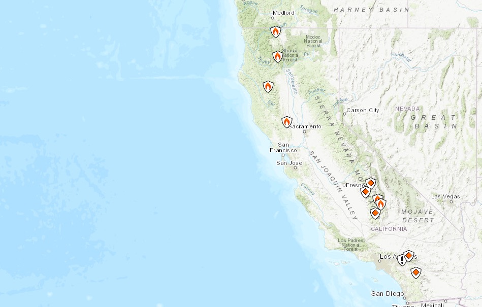
Interactive Map of California Fires
This map below is an interactive map of the more significant fires in California, consistently updated and provided by CAL FIRE and Google. Fires in red are active and fires in black are contained. If the map doesn’t show below, just go here.
Here’s Inciweb’s map. See the full map here.
CalFire
Next are more specific details on the fires for June 13, 2019. If you are looking for a specific fire, search for the name so you can find it faster, or just scroll down and look at the fires, listed in alphabetical order.
List of Active Fires in California on June 24, 2019
Here are the active fires and updates about them. Most of these are in alphabetical order.
66 Fire
The 66 Fire is off Avenue 66 in Thermal in Riverside County. It’s 77 acres as of the end of May and still listed on Cal Fire’s map. It was first reported on May 29 and was 75 percent contained as of May 30. Forward progression was stopped. On May 31 the fire was transitioned to the Bureau of Indian Affairs, but it’s still listed as active on Cal Fire’s map.
Ash Mountain Prescribed Burn
Listed on Inciweb, this is a prescribed fire to help prevent wildfires from getting out of control.
Bluff Mesa Prescribed Burn
Listed on Inciweb, this is a prescribed fire to help prevent wildfires from getting out of control.
Cedar Central Prescribed Burn
Listed on Inciweb, this is a prescribed fire to help prevent wildfires from getting out of control.
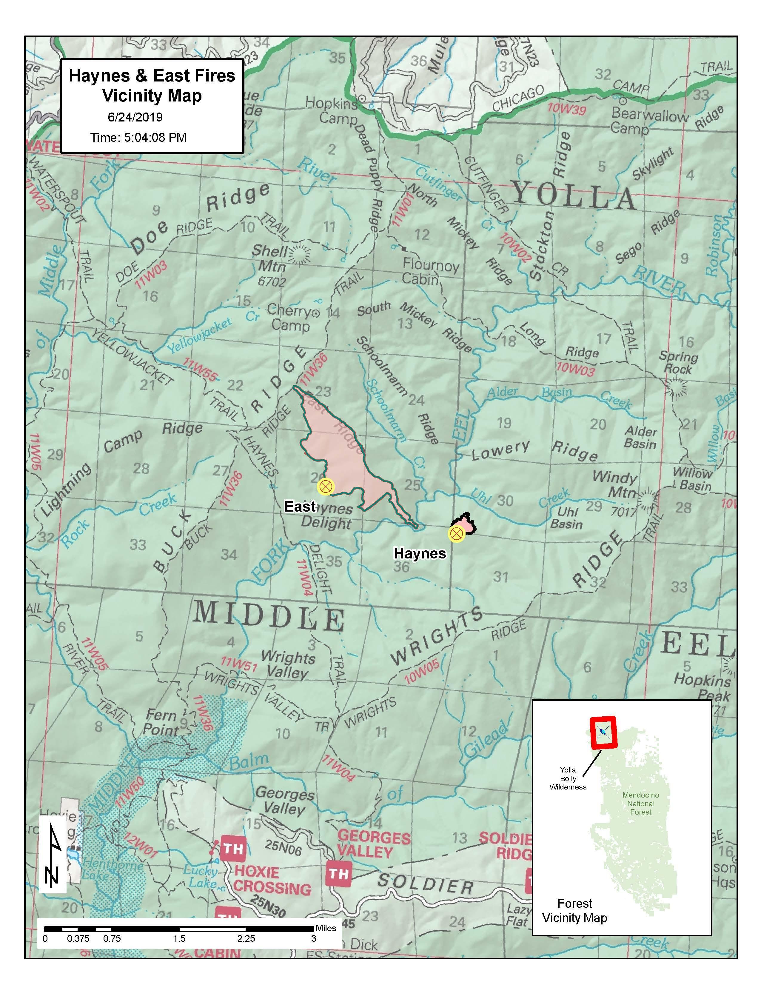
East Fire
Inciweb
This fire is 378 acres and 10 percent contained as of June 23 at 8:21 p.m. It was caused by lightning and is located 43 miles west of Red Bluff, California. It’s spreading southeast, according to Inciweb. It was first reported on June 17. It’s burning in the Yolla Bolly Middle Eel Wilderness.
Inciweb quoted Incident Commander Terry Warlick as saying: “The Mendocino National Forest has guidance to permit lightning fires to play, as nearly as possible their natural and ecological role within the wilderness to reduce unnatural accumulation of fuels as well as decrease exposure and risk to fire personnel. With firefighter and public safety at the forefront, we are managing this incident toward an outcome which will help improve forest health, protect wilderness characteristics and reduce the potential for a high severity wildfire in this area in the future.”
Jerry Fire
#JerryFire off Gilman Springs Road, between Highway 60 and Jack Rabbit Trail in Riverside County is 525 acres and 100% contained. t.co/hDc7E81yUj
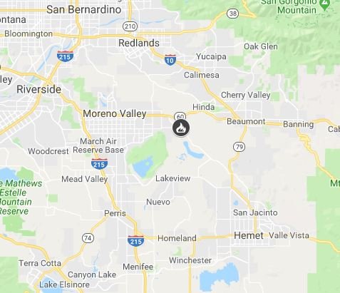
The Jerry Fire off Gilman Springs Road, between Highway 60 and Jack Rabbit Trail, is no longer listed as active on Cal Fire. The 525-acre fire in Riverside County is now 100 percent contained.
Jordan Fire
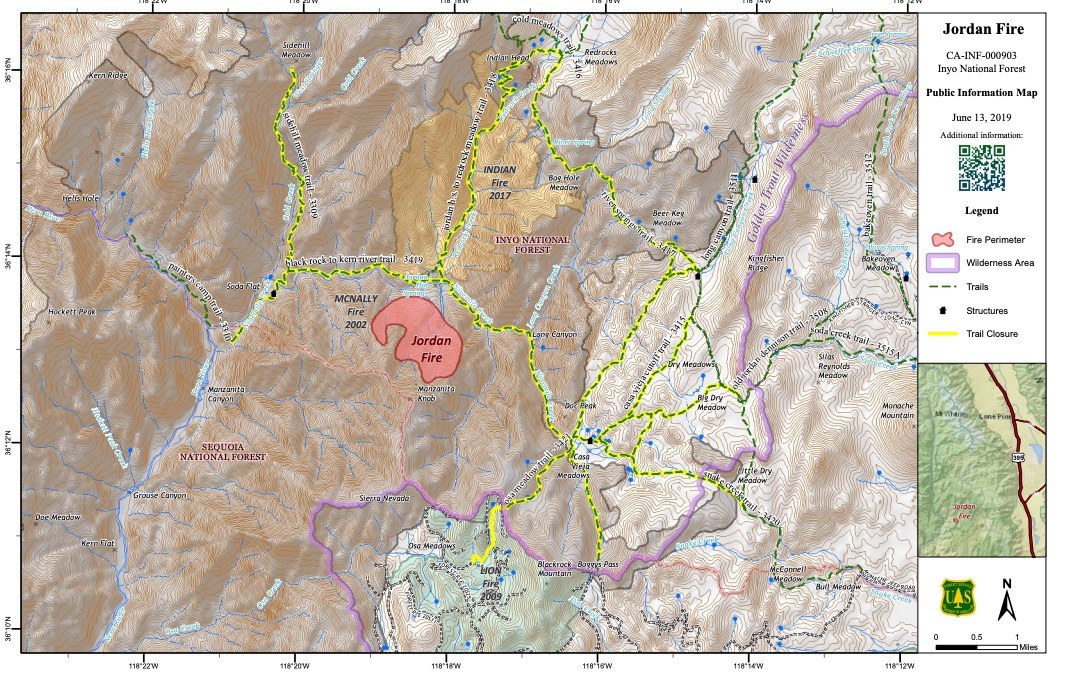
InciwebJordan Fire Map
Listed by Inciweb, this fire is in the Golden Trout Wilderness area near Jordan Hot Springs. It’s 591 acres and 80 percent contained as of June 17, the last update on Inciweb. It’s 26 miles southwest of Lone Pine, California. It was caused by lightning.
On June 21 it was noted by other sources that the fire was listed as being 100 percent contained.
7:05am 6-21-19 VEGETATION FIRE #JordanFire in #TulareCounty Due to better mapping the fire is at 322 acres and is 100% contained.
Inciweb: t.co/nlTpBCU4IB
Inciweb wrote on June 17: “Continued warm and dry weather cautions fire managers to keep a limited number of firefighters on the fire to guard against increased fire activity. Fire crews no longer required on the Jordan Fire are being flown back to Lone Pine Incident Command Post to start the demobilization process. After showers, clean uniforms and necessary paperwork, crews will be released to head home to rest and prepare for their next assignment.”
June Lightning Fires 2019 (Bald Fire and Lost Fire)

Inciweb
In Kernville, California, two fires were discovered this week in the Sequoia National Forest from lightning, Inciweb wrote. These are the Bald Fire and the Lost Fire. The Bald Fire is 2.5 acres as of June 21. The Lost Fire is 13 acres as of June 21. Both have minimal activity and smoke. They’re a total of 15 acres with 2 percent containment. Lost is east of Jackass and north of Dead Horse Meadow. Bald is five miles northwest of Bald Mountain Lookout.
Kern River Ranger District Prescribed Burn
Listed on Inciweb, this is a prescribed fire to help prevent wildfires from getting out of control.
Lumgrey Fire
This fire is listed as active on Cal Fire’s map. It’s off Highway 96 and Lumgrey Road, west of Gottsville, according to Cal Fire. The fire is in Siskiyou County. According to Inciweb, it’s 207 acres and 95 percent contained as of June 21. The cause is under investigation. The June 21 update was the final update due to successful containment.
Paskenta Fire
The Paskenta Fire off Corning Road and Paskenta Road, west of Corning, is no longer listed as active on Cal Fire. The 46-acre fire in Tehama County is now 100 percent contained.
Sand Fire
This fire is off County Road 41 and Highway 16 in Rumsey in western Yolo County. One June 13 the fire was 2,512 acres and 90 percent contained. It’s listed on Inciweb as a 335-acre fire.
SHF Lightning Fires 2019
A series of small forest fires have ignited in the Shasta-Trinity National Forest area, caused by lightning. Here’s the incident list from Inciweb:
- 06/16/2019 17:11 CHINA Lat,Lon – 40 53.394, -123 8.508 Geographic – Backbone Ridge on the Trinity River Management Unit, 1.5 acre, Contained 06/17/19 1800
- 06/16/2019 16:19 CREEK Lat,Lon – 41 05.094, -122 47.868 Geographic – Boulder Creek drainage on the Trinity River Management Unit, Single Tree, Contained 06/18/19 1334
- 06/16/2019 14:28 BOULDER Lat,Lon – 41 04.596, -122 46.770 Geographic – Boulder Lake Trailhead on the Trinity River Management Unit, .10 acre, Declared out on 06/18/19 1200
- 06/15/2019 18:38 BOWERMAN Lat,Lon – 40 53.910, -122 45.25 Geographic – Bowerman Barn area on the Trinity River Management Unit, .25 acre, Declared out on 06/20/19 1535
- 06/04/2019 15:13 PORTER Lat,Lon – 41 3.876, -122 38.454 Geographic – S of Bonanza King north of Trinity Lake, 3 acres, Declared out on 06/20/19 1700
- 06/03/2019 17:42 GROUSE Lat,Lon – 40 24.882, -123 22.068 Geographic – NW of Forest Glen on the Trinity River Management Unit, .25 acreage, Declared out on 06/05/19 0856
- 06/03/2019 17:24 DEVIL Lat,Lon – 40 18.888, -123 17.484 Geographic – NW of Horse Ridge on the Trinity River Management Unit, 0.10 acres, Declared out on 06/07/19 1344
- 06/03/2019 14:48 PICKETT Lat,Lon – 40 21.486, -123 23.172 Geographic – SW of Forest Glen on the Trinity River Management Unit, .34 acreage, Declared out on 06/05/19 at 1230
- 06/02/2019 16:44 RUSH Lat,Lon 40 49.596, -122 51.330, Geographic – between Tannery Gulch and Hwy 3 on the Trinity River Management Unit, 01 acreage, Declared out on 06/10/19 1213
Thomas Mountain Prescribed Burn
Listed on Inciweb, this is a prescribed fire to help prevent wildfires from getting out of control.
This is a developing story.