
Inciweb California fire map
Fires continue to cause problems in California during the hot, dry summer. Here’s a look at the latest wildfires being reported on August 15, 2019, including the San Jose Bayliss fire, a San Diego fire, a new fire in Campo, a Patterson fire which forced evacuations, and more. This article first includes interactive maps for all of California, including Cal Fire and other sources. Then the second section details specific fires in the region in alphabetical order. Remember that when it comes to fires, details can change quickly, so also stay tuned to your local news sources if there is a fire in your region.
Interactive Maps of California Fires
There are two interactive maps to follow to get the best updates about California fires this summer. In many cases, the fires don’t always overlap so it’s good to review all the maps for the latest information.
A previously helpful map was provided by CAL FIRE and Google. Unfortunately, this map hasn’t been updated in a while, so we’re no longer embedding the map in the story.
Instead, one of the best interactive maps available right now is Inciweb’s map. You can see the full map here. There’s an embeddable Google Map that includes Inciweb fires which you can see below. Depending on your browser, you may need to zoom in using the + button within the map or change settings on the Layers tab of Legend to only show Inciweb fires:
Another good map can be found here from Ca.gov. A screenshot is below since the map can’t be embedded, but you’ll want to go to the full map for details. You can input your address to see how close the fires are to your location.

Ca.gov
Each of these maps often contains details the others are missing, so you’ll need to view all three for a full update on the fires. However, brand new fires may not be listed on any of the above maps until they’ve been around for a few hours.
Next are more specific details on the fires for August 15, 2019. If you are looking for a specific fire, search for the name so you can find it faster, or just scroll down and look at the fires, listed in alphabetical order.
List of Active Fires in California on August 15, 2019
Here are the active fires and updates about them. Most of these are in alphabetical order.
Bayliss Fire in San Jose
This fire was first spotted on August 15. Fire crews began making progress quickly.
UPDATE Fire crews making progress on #BaylissFire t.co/V2XMrakoPN
The fire started when a car crashed into a power pole in San Jose, CBS reported. The fire is located on both sides of Santa Teresa Blvd. near Bailey Ave. and power lines are down. As of 1:45 p.m. at least 75 acres had burned.
#Baylissfire [update] at Santa Teresa Blvd cross Bailey Ave in South San Jose (Santa Clara County) CAL FIRE air tactical A460 reporting approximately 75 acres and forward progress has stopped. @SJFD
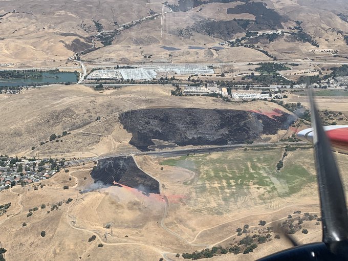
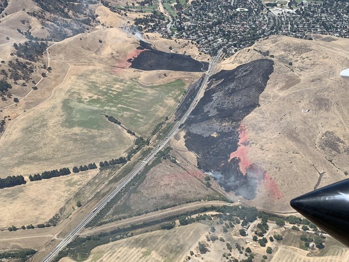
Forward progress has been stopped.
Border 9 Fire
.@CALFIRESANDIEGO is responding to a reported vegetation fire on Marron Valley Rd. near Dulzura.
#Border9Fire
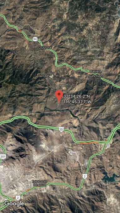
A vegetation fire called the Border 9 Fire started near Dulzura on Marron Valley Road in San Diego County. The fire is now 30 acres in size.
Dixon Fire
This fire is nine acres in size and was caused by lightning. It’s east of Silver Peak on Carson Iceberg Wilderness, Inciweb reported.
Inciweb noted on August 14: “Humboldt-Toiyabe National Forest fire managers continue to make use of a lightning-caused fire to meet multiple resource objectives in the Carson-Iceberg Wilderness. The Dixon Fire is located east of Silver Peak on the north side of Dixon Creek and was discovered on July 28 by aerial reconnaissance after storms passed through the area.
The Dixon fire remains deep in the Wilderness and is being managed for the following multiple objectives: reducing accumulated forest fuels, reintroducing fire into the ecosystem, ensuring firefighter and public safety, and decreasing the risk of future catastrophic fires in the area. The fire has seen minimal growth over the last week, remains approximately nine acres in size, and continues to burn at a low intensity.”
June Lightning Fires 2019 (Bald Fire and Lost Fire)

Inciweb
In Kernville, California, two fires were discovered in the Sequoia National Forest from lightning, Inciweb wrote. These are the Bald Fire and the Lost Fire. Together they have burned about 122 acres as of July 16. The good news is that as of July 23, both fires are 100 percent contained at 122 acres.
La Posta Fire in Campo
A fire started in the early evening of August 15 in Campo called La Posta Fire. It’s burned less than an acre and has already involved a structure in the 33000 block of Highway 94.
.@CALFIRESANDIEGO is at scene of a fully involved structure fire with extension into the vegetation in the area of the 33000 block of Hwy 94 in Campo.
#LaPostaFire

This fire started around 5 p.m. NBC 7 reported it was in the 33500 block of State Route 94. A home was shown in flames and the fire had spread to nearby vegetation.
Mill Fire
This fire in Monterey County is 280 acres and 100 percent contained as of August 13.
#MillFire 🔥 unofficial, automated update.
@LosPadresNF; ~20mi WSW of Pine Canyon, CA. ⚠️ DO NOT USE FOR SAFETY PURPOSES – See officials instead. May be incorrect; disclaimers in images.
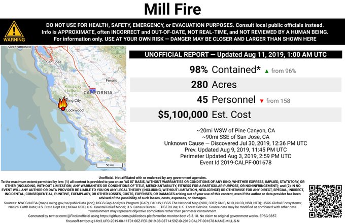

It was in Los Padres National Forest, west of Fort Hunter Liggett, according to Ca.gov.
The cause is being investigated.
Moose Fire
This is one of the more worrisome fires at the moment because it caused evacuations despite its smaller size. The fire is 225 acres and 75 percent contained as of August 15. It’s in Mendocino County, off Moose Road and Bus McGall Road, northwest of Hopland.
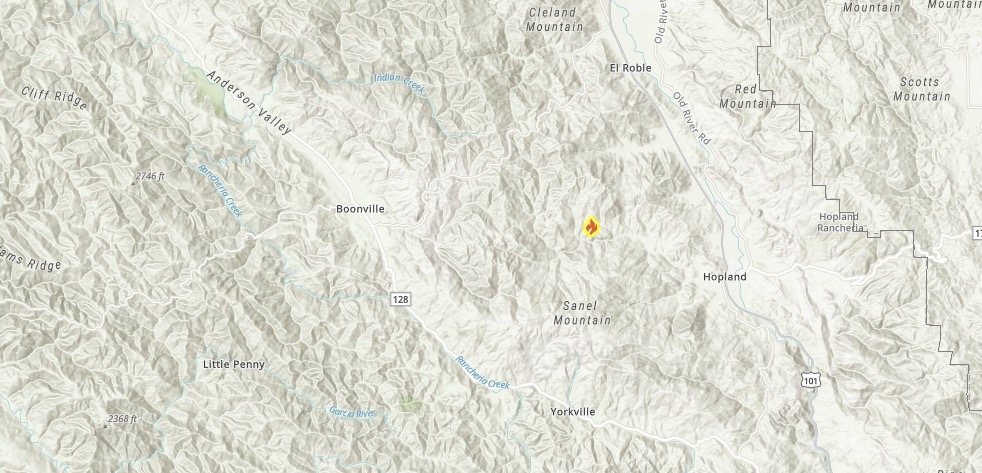
Ca.gov
No structures are threatened and no structures were damaged from the fire. As of August 15, there are no mandatory evacuations or road closures.
Patterson Fire
New Incident: #PattersonFire started off Patterson Drive, south of Placerville in El Dorado county is 20 acres.

The Patterson Fire, which started off Patterson Drive in El Dorado County (south of Placerville) is now 20 acres in size.
Evacuations had to be put in place for this fire in El Dorado County’s Diamond Springs area. It’s near the end of Patterson Drive close to the Martinez Creek drainage area, KCRA 3 reported. Some homes were placed under a mandatory evacuation, including homes on Dutch Mine Road, Tombstone Court, No Way Out Court, and Cerrito Road.
Sherman Prescribed Burn
Listed on Inciweb, this is a prescribed fire to help prevent wildfires from getting out of control.
SHF Lightning 2019
As of August 13, 33 lightning fires had started from recent storms from August 8-10. Here’s a look at the current status of those fires:
South Fork Management Unit (Hayfork and Platina area)
08/09/2019 19:56, PINE, W of Brushy Mtn, 0.25, acre, Out
Trinity River Management Unit (Weaverville, Big Bar, Trinity Lake, Trinity Alps)
08/10/2019 19:11, MONTGOMERY, Montgomery Ridge near Hwy 3 0.1 acre, Out
08/10/2019 07:21, TANGLE, Tangle Blue Creek and Hwy 3, 0.1 acre, Out
08/11/2019 12:51, STONEY, Stoney Point Trinity Lake, 0.1 acre, Out
08/12/2019 13:22, SUNFLOWER, Near Sunflower Creek, 0.5 acre, Controlled
08/12/2019 15:00, SHERER, S of Sherer Ridge, 0.71 acre, Contained
08/12/2019 15:00, BARNUM, Near Big French Creek, 1.7 acres, Contained
08/12/2019 16:00, PANSY, Near Swift Creek, 0.75 acres, Contained
08/12/2019 16:00, BUSHY, Granite Peak Rd, .75 acres, Out
08/13/2019 1600, COFFEE, Near Billy’ Peak, 0.1 acre, Contained
08/13/2019 16:06, Ridge, NE of Sunflower Flat, 0.1 acre, Controlled
Shasta Lake Ranger District and the National Recreation Area (Shasta Lake)
08/10/2019 09:15, DONEY, NW of Lakehead, 0.1 acre, Out
08/10/2019 11:21, DOOLES, N of Salt Creek Mtn, 0.1 acre, Controlled
08/10/2019 10:41, SPRING, Across canyon from Prospect Creek, 0.1 acre, Out
08/10/2019 11:24, SALT, N of Salt Creek Mtn, 0.1 acre, Controlled
08/10/2019 19:00, CHARLIE, NW of Lakeshore East, 0.1 acre, Out
08/10/2019 09:57, PROSPECT, W of Shoeinhorse Mtn, 0.1 acre, Out
08/10/2019 07:14, BRUSHY, Near Brushy Canyon, 0.25 acre, Out
08/10/2019 09:57, HAPPY, Happy Hunting Grounds, 0.1 acre, Out
08/10/2019 17:58, HUNTING, W of Iron Canyon Reservoir, 0.1 acre, Out
08/11/2019,12:45, HOOVER, Squaw Arm Shasta Lake, 0.5 acre, Out
08/11/2019 10:44, MUDDY, East side of Garden Ridge, 3.5 acres, 90 % contained
Shasta McCloud Management Unit (Mt Shasta and McCloud area)
Shasta McCloud Management Unit (Mt Shasta and McCloud area)
08/10/2019 11:28, ZOT, Near Hazel Creek Rd, 0.1 acre, Patrol
08/10/2019 13:15, TOAD, E of Toad Mtn, 0.1 acre, Patrol
08/10/2019 16:41, CINDER, E of Hotlum near Cinder Cone, 0.1 acre, Out
08/10/2019 16:16, BEAR, N of Gumboot Lake, 0.1 acre, Patrol
08/10/2019 19:25, FISCHER, Across from Sims Flat, 0.1 acre, Out
08/10/2019 12:13, SISSON, Rocky high elevation on Mt Eddy, 0.1 acre, Out
08/10/2019 16:17, WHITE, N of Bear Ridge, S of 0.1 acre, Patrol
08/10/2019 15:53, FRENCH, W of Sugarloaf 0.1 acre, Patrol
08/10/2019 20:01, PICAYUNE, W of Porcupine Lake, 0.1 acre, Patrol
08/12/2019 16:54, GAZELLE, Near Dewey Mine, 0.1 acre, Patrol
08/13/2019, 16:46, CRATER, Near Harris Mtn, 0.1 acre, Patrol
08/12/2019 17:30, TRINITY, NE of Sherer Ridge, 5.5 acres, 55 % contained
Springs Fire

Inciweb
This fire is now 1,614 acres and 15 percent contained, according to Inciweb on August 15, the latest update. It was caused by lightning. It’s located 13 miles southeast of Lee Vining. The map above is from August 15, the most recent Inciweb map.
On August 15, Inciweb wrote: “The Springs Fire is being managed with a strategy to reintroduce fire into the landscape in its’ natural role. Overnight firefighters continued to prep and strategically apply fire to the landscape to further secure the fire to containment lines. Last night an Unmanned Aircraft System (UAS), commonly referred to as a drone was used in firing operations. Smoke is expected to be variable and depends on the daily winds. From evening into early morning smoke may drain into the Long Valley area, potentially impacting the community of Crowley Lake. As winds shift late morning into early afternoon the smoke will begin dispersing towards Mammoth Lakes, Devils Postpile, June Lake, and Lee Vining. Benton may expect lighter smoke later in the afternoons as winds are expected to shift out of the southwest.”
University City / San Diego Fire / Rose Canyon Fire
On Thursday afternoon August 15, San Diego fire crews responded to a fire in University City, CBS 8 reported. This fire was near the 4100 block of Porte de Merano, burning near train tracks. Train service nearby was stopped. CBS 8 noted this was the approximate location of the fire:
This is also being called the Rose Canyon fire by some.
Ward Fire
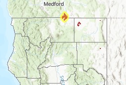
Ca.gov
This fire is in Oregon but near the border with California. It’s currently 1,301 acres and 63 percent contained as of August 15. That’s a nearly 30 percent containment increase in just two days. The cause is under investigation. The fire started August 9 and is near Highway 66 and Ward Road, about 13 miles west of Keno, Oregon. It’s also 18 miles southwest of Klamath Falls.
You can follow updates on the fire’s Facebook page. The last update was released yesterday. The fire is under such good control that they will only release new updates if something changes significantly.