Inciweb
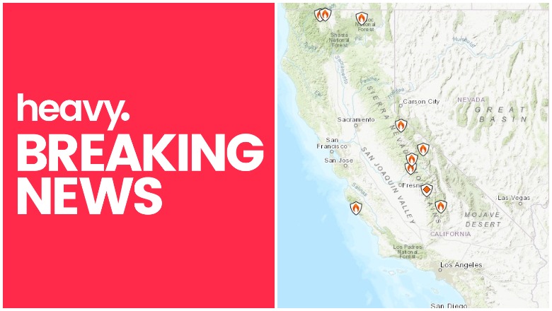
Fire season continues in California as hot, dry weather creates favorable conditions for quick-burning fires. Here’s a look at the latest wildfires being reported on August 3, 2019. This article first includes interactive maps for all of California, including Cal Fire and other sources, including a recent fire in the Castaic area. Then the second section details specific fires in the region in alphabetical order. Remember that when it comes to fires, details can change quickly, so also stay tuned to your local news sources if there is a fire in your region.
Interactive Maps of California Fires
There are three interactive maps to follow to get the best updates about California fires this summer. In many cases, the fires don’t always overlap so it’s good to review all the maps for the latest information.
The first map is an interactive map of the more significant fires in California, provided by CAL FIRE and Google. Unfortunately, this map hasn’t been updated in awhile and as of July 28 it still hasn’t been updated, which is unusual. So we’re no longer embedding the map in the story. You can view the map here.
The second good interactive map is Inciweb’s map. You can see the full map here. There’s an embeddable Google Map that includes Inciweb fires which you can see below. Depending on your browser, you may need to zoom in using the + button within the map or change settings on the Layers tab of Legend to only show Inciweb fires:
Another good map can be found here from Ca.gov. A screenshot is below since the map can’t be embedded, but you’ll want to go to the full map for details. You can input your address to see how close fires are to your location.

Ca.govCalifornia Fire
Each of these maps often contains details the others are missing, so you’ll need to view all three for a full update on the fires. However, brand new fires may not be listed on any of the above maps until they’ve been around for a few hours.
Next are more specific details on the fires for August 3, 2019. If you are looking for a specific fire, search for the name so you can find it faster, or just scroll down and look at the fires, listed in alphabetical order.
List of Active Fires in California on July 28, 2019
Here are the active fires and updates about them. Most of these are in alphabetical order.
Bowler Fire
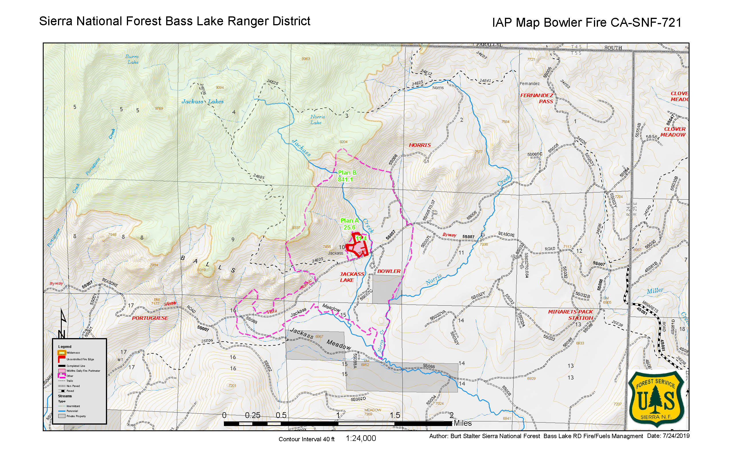
This fire was first spotted on July 24. As of August 1, the fire was 100 percent contained, although it’s still listed as active on Inciweb’s map. It grew to 40 acres.
Caliente Fire
This fire was reported on August 1. As of August 2 it’s 490 acres and 60 percent contained, reported Ca.gov. It’s in San Diego County off Airway Road and Caliente Ave., in San Ysidro.
Later reports indicated it’s at 75 percent containment now.
Sadly, business owners lost a lot in this fire, 10 News reported. Francisco and Carolina Ramirez had a pallet yard in the area that they started 25 years ago to recycle wood and plants. Atlas Wood Pallets was destroyed.
Community Fire
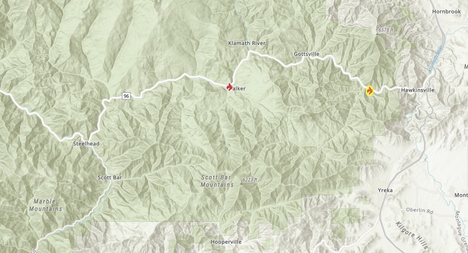
Ca.gov
As of August 3, this fire was 35 acres and 60 percent contained, according to CA.gov. (Inciweb lists it as 70 percent contained.) It’s the fire on the left in the map above. It was discovered July 27 at Highway 96 near Klamath River Community Hall. This was one of five fires that broke out in Siskiyou County at the same time. The cause is under investigation.
Dixon Fire
This fire is 8 acres in size and was caused by lightning on July 28. It’s east of Silver Peak on Carson Iceberg Wilderness, Inciweb reported. Inciweb noted: “Humboldt-Toiyabe National Forest fire managers are making use of a lightning-caused fire to meet multiple resource objectives in the Carson-Iceberg Wilderness. The Dixon Fire is located east of Silver Peak on the north side of Dixon Creek and was discovered on July 28 by aerial reconnaissance after storms passed through the area.”
Fish Fire
Listed on Inciweb’s map as an active fire, the Fish Fire was 77 acres is now 100 percent contained as of July 19. It was in the Sierra National Forest and was discovered on the afternoon of July 15, near the Fish Creek Campground. No structures were threatened.
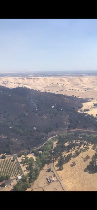
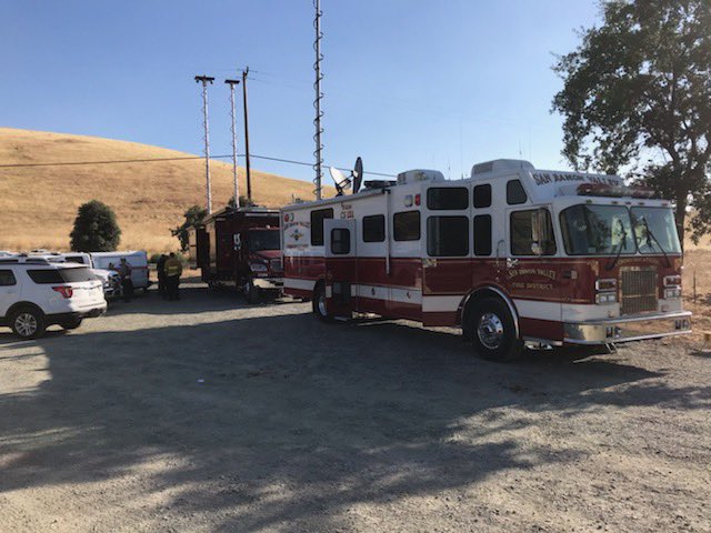
Five Fire in Castaic
Working the #FiveFire #5Fire in @Angeles_NF @local1014 @LACoFDPIO @CHP_HQ @LASDHQ
The Five Fire in the Castaic region just started on August 3, ABC 7 reported. Near the 5 Freeway, this brush fire quickly grew to 100 acres. It started two miles north of Templin Highway just before 1:30 p.m. Two lanes on the freeway were closed.
Conditions are improving on the #FiveFire #5Fire in @Angeles_NF @local1014 @LACoFDPIO @CHP_HQ @LASDHQ
The good news is that conditions are starting to improve, but some sources are now saying it’s 150 acres. Stay alert if you are in the region.
June Lightning Fires 2019 (Bald Fire and Lost Fire)

Inciweb
In Kernville, California, two fires were discovered in the Sequoia National Forest from lightning, Inciweb wrote. These are the Bald Fire and the Lost Fire. Together they have burned about 122 acres as of July 16. The good news is that as of July 23, both fires are 100 percent contained at 122 acres.
The Bald Fire, discovered June 17, was 5 miles northeast of Bald Mountain Lookout.
The Lost Fire, discovered June 18, was east of Jackass and north of Dead Horse Meadow.
Marsh Complex Fire
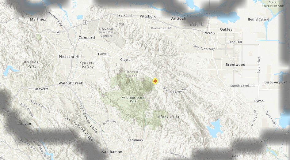
Ca.govMarsh Complex Fire
This fire is 655 acres and 0 percent contained as of August 3, according to Ca.gov. However, CBS 5 indicates it’s now 50 percent contained. It’s in Contra Costa County near Marsh Creek Road and Morgan Territory Road.
The fire is southwest of Brentwood. Technically it consists of up to 12 fires combined in the “complex” category.
#marshcomplex (update) Marsh Creek Rd and Morgan Territory Rd west of the community of Brentwood (Contra Costa County) Over 300 firefighters continue to work on containing the three largest fires in the complex. Fire is holding at 655 acres and 50% contained.


A shelter in place has been issued for people near Clayton. Residents are asked to close their doors and windows and stay inside because of smoke from the fire. The fire was first reported after 3 a.m., CBS 5 reported. The cause is under investigation.
Mesa Fire
#MesaFire 🔥 unofficial, automated update.
At Squirrel Mountain Valley, CA. ⚠️ DO NOT USE FOR SAFETY PURPOSES – See officials instead. May be incorrect; disclaimers in images.
t.co/LzALj30Yki


This fire is 227 acres and 85 percent contained as of August 2, according to Ca.gov. It’s in Kern County near Quail Road and Bobcat Drive. It’s south of Lake Isabela in the Kern River Valley region.
Mill Fire
Ca.gov
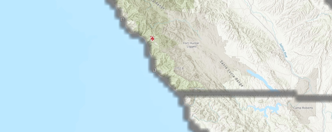
This fire in Monterey County is 280 acres and 20 percent contained as of August 2. It’s in Los Padres National Forest, west of Fort Hunter Liggett, according to Ca.gov. The cause is being investigated.
#MillFire holding at 310 acres & 50% containment. Crews will continue reinforcing line & snuffing out hotspots within the perimeter. Air resources based at the Fort Hunter Liggett helibase are available to support crews on the ground until the fire is declared OUT.

Other sources have indicated the fire is 310 acres with 50 percent containment as of August 3.
Range Fire
#RangeFire 🔥 unofficial, automated update.
~8mi ENE of Santa Ynez, CA. ⚠️ DO NOT USE FOR SAFETY PURPOSES – See officials instead. May be incorrect; disclaimers in images.
t.co/J0XkWjHgMz
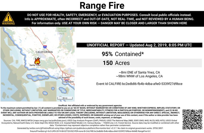
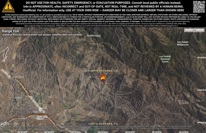
This fire is in the Los Padres National Forest region, north of Lake Cachuma. It’s 150 acres and 95 percent contained as of August 2, according to Ca.gov. It started on July 28.
Officials are anticipating 100 percent containment by Sunday.
Sherman Prescribed Burn
Listed on Inciweb, this is a prescribed fire to help prevent wildfires from getting out of control.
Springs Fire
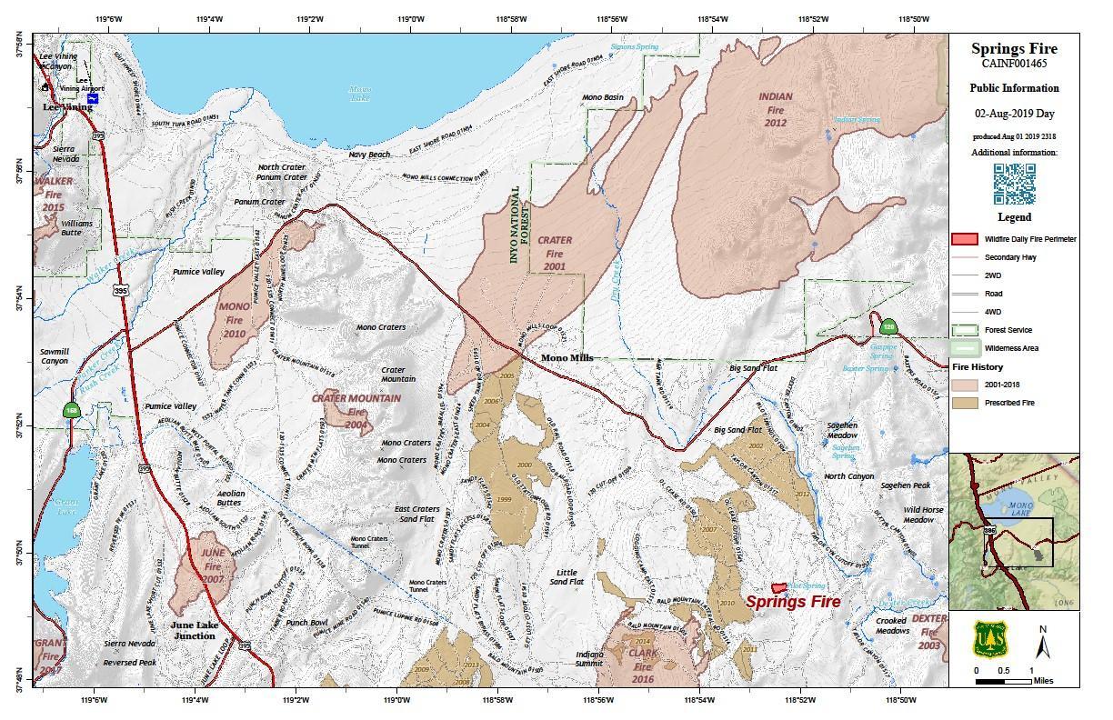
InciwebSprings Fire
This fire is 35 acres and 1 percent contained as of August 3, Inciweb reported. It was caused by lightning on July 26. It’s 13 miles southeast of Lee Vining, California. Moderate activity is expected over the next 12-72 hours.
Inciweb wrote on August 3: “Crews made good progress yesterday in control line construction on the eastern flank of the fire, limiting fire spread into the Pilot Dry Creek. Most of yesterday’s 15 acres of fire growth was a result of tactical burning operations firefighters used to remove vegetation between indirect fire lines and the main fire. This provides more depth to the control line to secure an established anchor point. Fire managers and crews on the fireline anticipate a growth of 30 acres today. “The observed fire behavior indicates benefits to forest health and was mostly low to moderate – smoldering and creeping in lodgepole pine needles and duff with 6-12 flame lengths and isolated single tree torching”, stated by the on-site Fire Behavior Analyst working with the Type 3 Incident Management Organization.”
Star Fire in Chino Hills
The Star Fire in Chino Hills, reported earlier this week, is 100 percent contained as of August 2. It burned 156 acres and damaged a multi-million-dollar home, Champion Newspapers reported. The damaged home is owned by Arthur Forrest and his wife Toni. Arthur is a dentist in Chino Hills.
Tree Fire
Ca.gov
On August 2, Ca.gov noted that this fire is 83 acres and 60 percent contained. (Inciweb notes that it’s now 70 percent contained.) It’s being overseen by Klamath National Forest officials and is in the Tree of Heaven campground, east of Gottsville. It’s the fire on the right in the map above. This was one of five fires that broke out in Siskiyou County at the same time.
The cause of the fire is under investigation. Inciweb will no longer update details about the fire unless it starts to grow again.
Tucker Fire
This fire is 14,217 acres and 74 percent contained as of August 2. Reports indicate that as of August 3 it’s now 95 percent contained. It’s in the Modoc National Forest region, off Highway 139 and Tucker Butter Road. It’s six miles southwest of Clear Lake Reservoir. The cause is under investigation.
Usal Fire
Ca.gov
This fire is listed on Ca.gov’s map. It’s 130 acres and now 99 percent contained as of August 3. The cause is under investigation. The fire started on July 27 at Usal Creek and Usal Road, about seven miles west of Leggett in Mendocino County, Ca.gov noted.