NOAA
The National Hurricane Center has released weather updates for Hurricane Dorian on August 28, 2019. These updates include new watch and warning areas, along with predictions for the storm that is slowly moving to the U.S. coast. You can read the full updates on the NOAA’s website here. Here’s a summary of the latest updates for the afternoon of August 28 as of 2 p.m.
Hurricane Dorian’s Location, Coordinates & Movement
NOAA
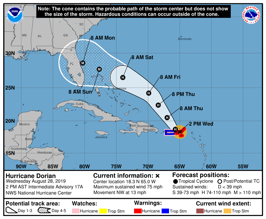
As of 2 p.m. on August 28, Dorian was located at 18.3 N, 65.0 W, at 0 miles west of St. Thomas. The storm is moving northwest or 315 degrees at 13 mph.
The National Hurricane Center noted the following at 2 p.m.: “Dorian is moving
toward the northwest near 13 mph (20 km/h), and this motion is expected to continue for the next day or two. On this track, Dorian should continue to move near or over the U.S. and British Virgin Islands this afternoon and then move over the open Atlantic well east of the southeastern Bahamas.”
Dorian is expected to continue strengthening over the next few days.
Tropical Storm Dorian’s Wind Strength, Pressure, & Rainfall
The storm’s maximum sustained winds as of 2 p.m. are 75 mph, with some higher gusts.

The minimum central pressure is 997 mb (29.44 inches.)
Rainfall is expected to be 1 to 3 inches at the Northern Leeward Islands, and 4 to 6 inches (isolated up to 10 inches) for eastern Puerto Rico, the Virgin Islands, and northwest Bahamas.
The storm could bring 2 to 4 inches of rain to western Puerto Rico and the central Bahamas.
Coastal areas of the southeast United States might see 4 to 8 inches of rain, and isolated areas up to 10 inches.
Current Watches & Warnings
According to the National Hurricane Center, the following warnings and watches are in effect as of 2 p.m.
Hurricane Warning
- Vieques and Culebra
- U.S. Virgin Islands
- British Virgin Islands
Hurricane Watch
- Puerto Rico
Tropical Storm Warning
- Puerto Rico
Additional watches and warnings may be issued, so stay tuned to local news for updates in your region.
Additional Hurricane Discussions Suggest the Storm May Eventually Become a Category 3
The NOAA’s 11 a.m. discussion included some more details.
“Satellite and radar images indicate that the cloud pattern has become better organized during the past several hours. This was confirmed by data from an Air Force reconnaissance plane currently investigating Dorian, which reported a flight-level wind of 72 kt
and a peak SFMR value of 60 kt. The estimated central pressure was 999 mb in the last fix. On this basis the initial intensity has been adjusted upward to 60 kt. Only a slow strengthening is anticipated today while Dorian is moving through the U.S. and
British Virgin Islands. However, once the cyclone reaches the western Atlantic well east of the Bahamas, it will encounter a favorable environment of low shear and warm waters, resulting in a more marked intensification. The NHC forecast is more aggressive than the previous one, and brings Dorian to category 3 intensity by the end of the period. This forecast very closely follows the intensity consensus, the HCCA model, and the SHIPS guidance.”
READ NEXT: WATCH: Man with TV on Head Leaves CRT TVs on Porches in Virginia