Inciweb/AICC
Quite a few fires are burning in Alaska today. Here’s a look at all of the major wildfires in the Alaska region that have been reported on September 7, 2019. The first section of this story will include an interactive map and the second section will list the fires individually in alphabetical order. Remember that when it comes to fires, details such as evacuations can change quickly, so stay tuned to your local news sources too.
Interactive Maps of Alaska Fires
Inciweb provides the best map of Alaska fires in the region. There’s an embeddable Google Map that includes Inciweb fires which you can see below. Depending on your browser, you may need to zoom in using the + button within the map, change the settings in the Legend window to only show Inciweb fires, or move the map to show Alaska.
You can also visit Inciweb directly here.
AlaskaCenters.gov recommends the AICC Current Fires Map of Alaska. Note that our story is only listing the major fires, and this map shows many fires of varying sizes. According to the map there are 181 active fires today. Red dots indicate fire origin and shaded red areas indicate active fire perimeters.
In the above map, you’ll need to click “OK” to actually view the map.
Below is a list of the bigger fires in Alaska today, listed in alphabetical order.
Large Fires in Alaska on September 7
Caribou Lake Fire
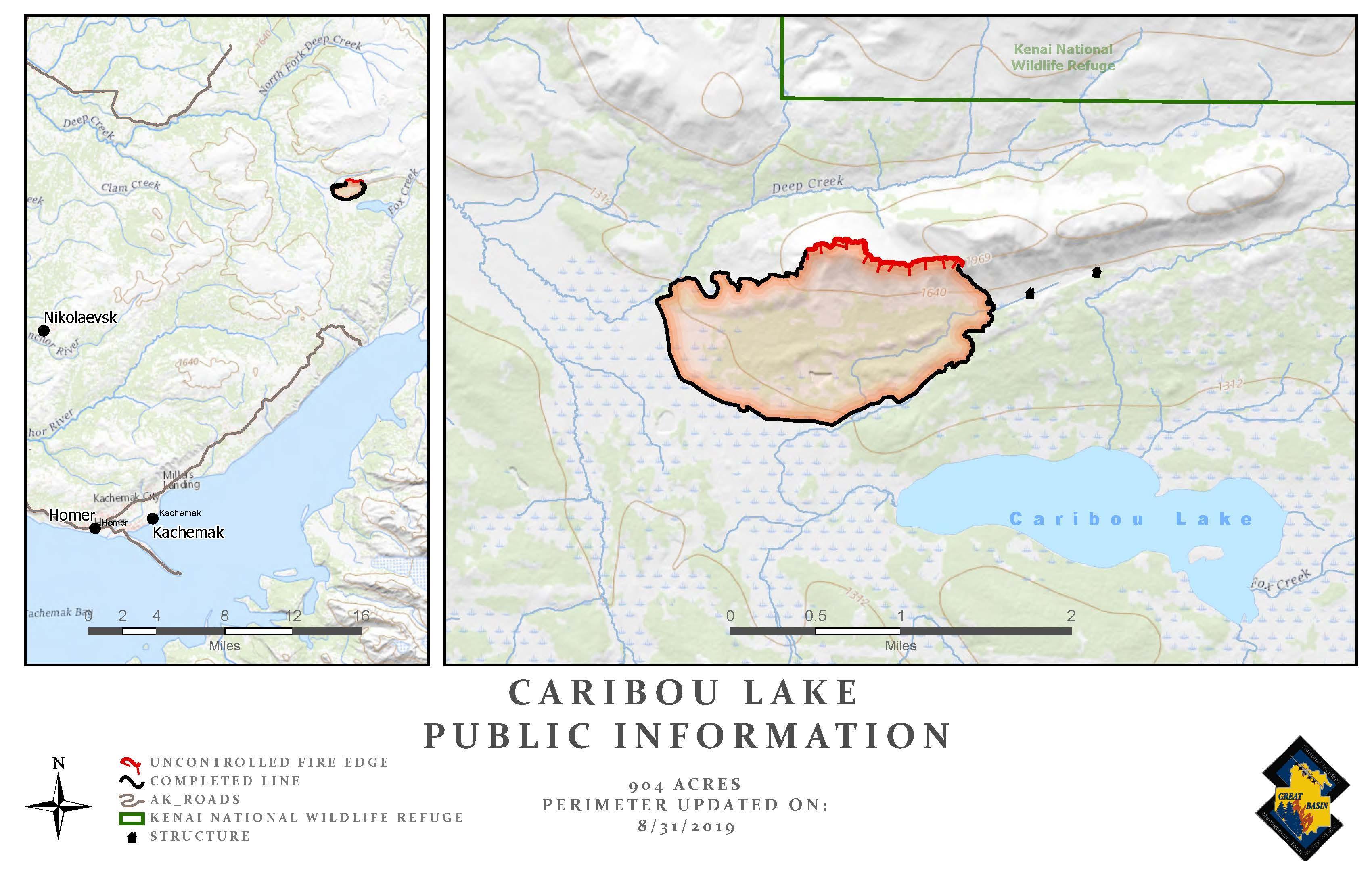
This fire is 870 acres and 94 percent contained. Inciweb posted its last update on September 6 unless something significantly changes. It’s 25 miles northeast of Homer, Alaska.
Inciweb noted: “No structures have been destroyed to date, and none are threatened at this time. There have been no injuries reported to date on the Caribou Lake Fire. The initial response and ongoing support from Kachemak Emergency Services has been critical for situational awareness and logistical support. The Caribou Lake Fire is being managed as a full suppression fire with a goal of 100 percent containment estimated by September 8, 2019. Smoke may be visible from within the interior of the fire perimeter until there significant and repeated rain or snow.”
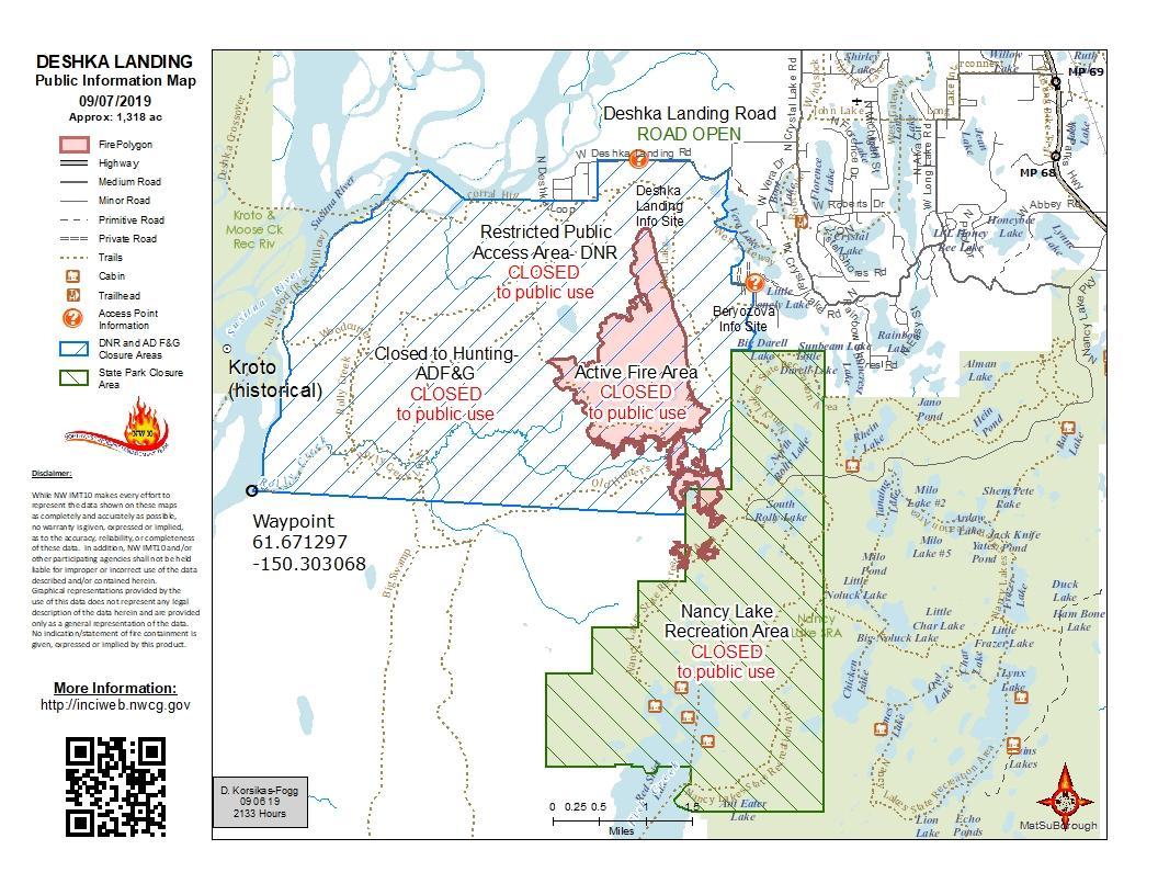
Deshka Landing Fire
Inciweb
This fire is 1,318 acres and 95 percent contained, according to Inciweb on September 6 at 9:54 p.m. The fire is five miles southwest of Willow, Alaska. The north half of the fire is in patrol status and mopping up is continuing for the south part of the fire. No growth is expected.
Regarding closures, Inciweb notes: “The recent closures of portions of Game Management Unit 14A, State lands in the area, and the western portion of the Nancy Lake Recreation area remain. Details about the closures can be found at: https://inciweb.nwcg.gov/incident/closures/6532/.”
Lower Klutuk Fire
#LowerKlutukFire 🔥 unofficial, automated update.
~10mi ESE of Ekwok, AK. ⚠️ DO NOT USE FOR SAFETY PURPOSES – See officials instead. May be incorrect; disclaimers in images.
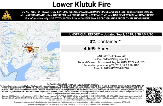

This fire is listed by NIFC but not by Inciweb. It’s 4,699 acres and 0 percent contained, and is being overseen by the Department of Forestry’s Southwest Area unit. It was started by a lightning strike in late August but wasn’t threatening any valuable assets, local news reported.
McKinley Fire
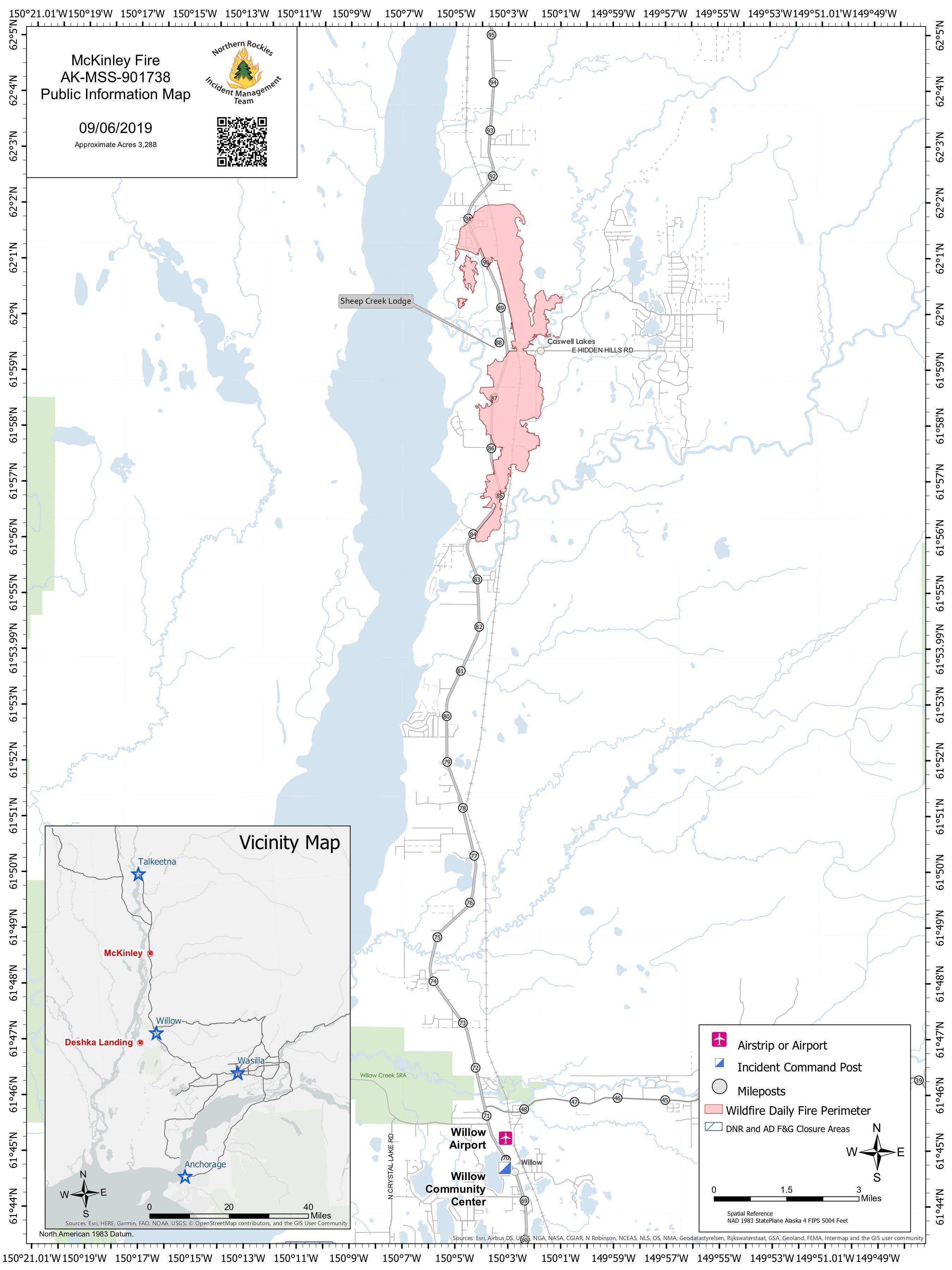
This fire is 3,288 acres and 95 percent contained as of September 7, according to Inciweb. Full containment is expected by October 1. It’s 18 miles north of Willow, Alaska.
Inciweb noted on September 6:
Extreme caution and a high level of awareness is urged for residents within the fire perimeter and woodcutters along the Parks Highway. Deep pockets of burning organic material called ashpits, along with snags pose significant dangers to anyone inside the burn area.
All power is restored to the area and any residents experiencing issues should call the Matanuska Electric Association. Residences from milepost 81.5 to 92 of the Parks Highway are still in evacuation “Level 1-Ready.” The Parks Highway speed limit remains 45 mph through the fire vicinity.
Closures: A portion of Willow Swamp (Game Management Unit 14A) is closed due to the Deshka Landing Fire. For more info, visit the Alaska Department of Fish and Game website at https://www.adfg.alaska.gov/. A Temporary Flight Restriction (TFR) is still in effect over the McKinley Fire.”
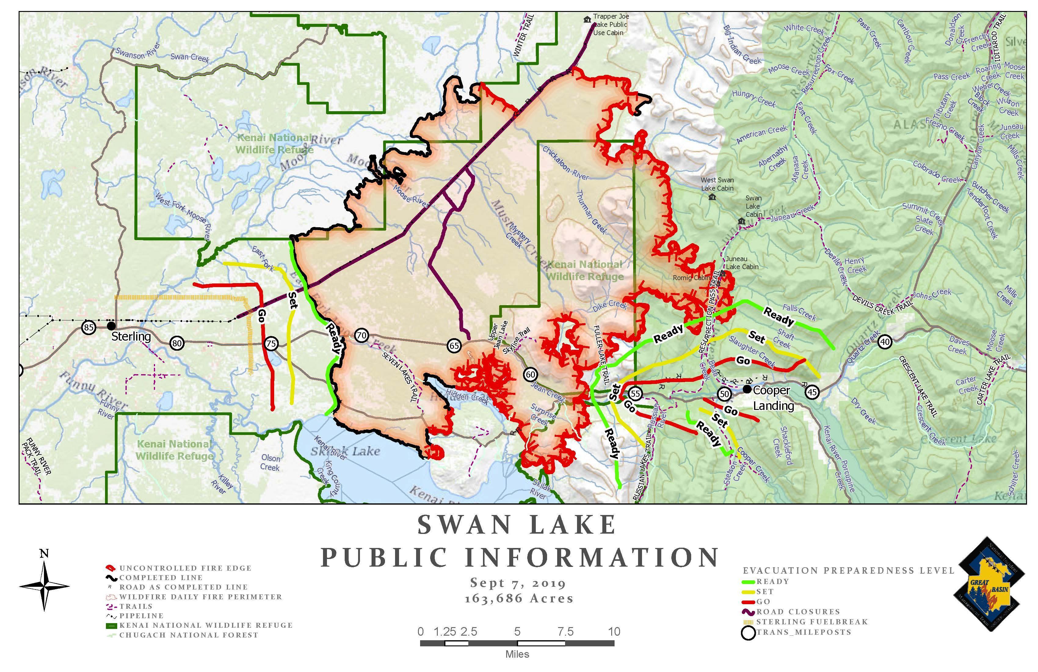
Swan Lake Fire
Inciweb
This fire is 163,686 acres and 30 percent contained. It was caused by lightning. As of September 6, Inciweb noted the following planned actions for the fire.
Continue securing fire lines along the southwest and southeast portions of the fire to keep fire within containment lines and away from the communities of Sterling and Cooper Landing. Hand crews continue mopping up and securing fire lines south of the Kenai River into the Kenai Wilderness. Crews will directly engage fire line along the Resurrection Trail corridor and on Russian and Bear Mountains. Structure group will continue working with local resources to staff and monitor fire lines adjacent to Cooper Landing. Continue to assist Homer Electric employees conducting damage assessments and Chugach electric for residential lines in Cooper Landing. Utilize aviation resources where needed to help secure fire edges and mop-up hot spots. UAS drones will be used to identify heat sources within the fire perimeter. Suppression repair plan is being finalized.”
Inciweb also noted on September 6:
Today is expected to be the last warm, sunny day before cooler weather moves in this weekend. As a result, travelers on the Sterling Highway should expect to see increased amounts of smoke, and possibly flames, in the areas south of the highway between Sterling and Cooper Landing. Some “islands” of unburned fuel remain and will continue to burn until additional moisture arrives. Some rain is possible Saturday night, accompanied by some strong winds but humidity is expected to remain high and moderate fire behavior.
Fire lines on the west side near Kenai Keys and Sterling continue to be “mopped-up” as firefighters patrol and look for any remaining hot spots to extinguish. Fire managers are confident the lines on the west side can withstand another test of wind, but also have alternate and contingency plans in place for the west side of the fire.”
According to AlaskaCenters.gov: “For updates on theSwan Lake Fire on the Kenai Peninsula please visit the Kenai Peninsula Borough Joint Information Center for daily updates. For fire information please visit the Incident Information System’s Swan Lake Fire profile.”
Tokaina Fires
The Tokaina Creek, Tokaina 2 and Tokaina 3 fires are listed by NIFC but not by Inciweb. Tokaina 2 is two miles east of Tazlina and listed as 9,265 acres and 0 percent contained. Tokaina 3 is 27 miles southwest of Glennallen and listed as 156 acres and 0 percent contained. The Tokaina Creek fire is 23 miles southwest of Glennallen and 823 acres and 0 percent contained, according to NIFC.
According to AKFireInfo, These fires were still being monitored on September 2 (but the Tokaina 4 fire has since been removed from NIFC’s list.)
READ NEXT: Hurricane Dorian Damage in the Bahamas: Videos Show Devastation