
Inciweb
In California, the Red Bluff Fire and the Tenaja Fire are getting the most attention, but there are many other fires causing issues in the state too. Here’s a look at the latest wildfires being reported on September 7, 2019. This article first includes interactive maps for all of California, including Cal Fire and other sources. Then the second section details specific fires in the region in alphabetical order. Remember that when it comes to fires, details such as evacuations can change quickly, so stay tuned to your local news sources. This story will provide links for where updates will be posted for each individual fire, when available.
Interactive Maps of California Fires
Here are interactive maps you can follow to get the best updates about California fires this summer. In many cases, the fires don’t always overlap on these maps, so it’s good to review all of them for the latest information.
One of the best interactive maps available right now is Inciweb’s map. You can see the full map here. There’s an embeddable Google Map that includes Inciweb fires which you can see below. Depending on your browser, you may need to zoom in using the + button within the map or change settings to only show Inciweb fires:
Another good map can be found here from Ca.gov. A screenshot is below since the map can’t be embedded, but you’ll want to go to the full map for details. You can input your address to see how close the fires are to your location.

Ca.gov
Remember: brand new fires may not be listed on the above maps until they’ve been around for a few hours.
A new interactive fire map is below, provided by UCANR.edu. Note that this map is only updated up to twice daily, so it may not be not as current as the two interactive maps above.
Next are more specific details on the fires for September 7, 2019. If you are looking for a specific fire, search for the name so you can find it faster, or just scroll down and look at the fires, listed in alphabetical order.
List of Active Fires in California on September 7, 2019
Here are the active fires and updates about them. Most of these are in alphabetical order.
Broder Fire
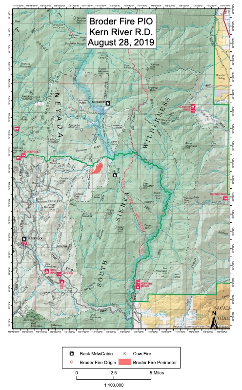
InciwebBroder Fire
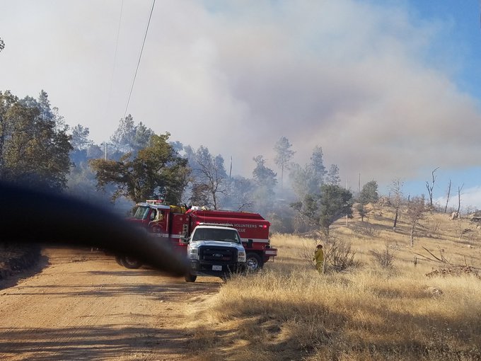
This fire is 370 acres in size and 30 percent contained as of September 5. It was started by lightning on August 8. It’s northeast of Broder Meadow and crews are using natural barriers to fight the fire, Inciweb noted in its most recent update.
Monache Meadows is open to recreationists, but use caution. The fire’s burning at a moderate rate of speed, Inciweb noted, and there may still be smoke in the region.
Country Fire
This fire is in El Dorado County, at Highway 193 and Penobscot Road east of Cool, according to Ca.gov. It’s 85 acres and 100 percent contained as of September 6, according to Ca.gov. Four structures were destroyed from this fire and there were two injuries.
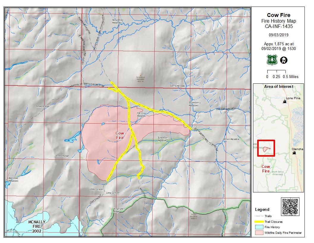
Cow Fire
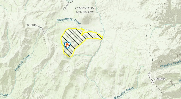
Inciweb
This fire is 1,975 acres in size and 30 percent contained, Inciweb noted on September 7. It was started by lightning on July 25 and is nearly 2,000 acres in size as of September 4. Planned actions on Sept. 7 include to “continue to bring the fire from the west to the east along the north side of the fire. On the south side, continue to strengthen the trail and meadow natural barriers to keep pace with the interior burning.”
The map below is the last map released by Inciweb for the fire.
Inciweb
The fire’s burning in the Golden Trout Wilderness on Inyo National Forest. The fire’s being successfully confined and suppressed. Inciweb released its final update on the fire on September 7. They wrote:
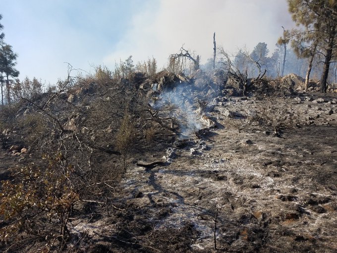
The 1,975-acre Cow Fire remains 30 percent contained. Minimal smoke may be visible from the Cow Fire until the area receives significant rainfall. Firefighters will continue to monitor the fire to ensure it stays within control lines. Containment will steadily increase as crews further secure control lines by identifying and extinguishing sources of heat along the fire perimeter.
The ecosystem within the Cow Fire footprint will benefit from the low-intensity fire effects observed on the landscape. Lightning-caused wildfires have a natural role to play in Eastern Sierra forest ecosystems. Burned materials recycle nutrients back into the soil which enriches it and stimulates vegetation growth. New grasses, shrubs and trees replenish and grow stronger while old growth stands become more resilient. Wildlife habitats are created and an increase in food becomes available for animals to forage. The hazardous accumulation of logs and overgrown surface fuels on the forest floor are reduced which diminishes the risk of severe wildfires in the future. Heat from fire opens the strong resin which holds seeds inside of the serotinous cones of Lodgepole Pine, allowing the species to reproduce.
The public is encouraged to avoid the fire area. Post-fire hazardous such as fire weakened trees and burning stump holes may be present.”
Flood Fire
The Flood Fire is in San Joaquin County near Flood Road and N. Waverly Road. It’s southwest of Rancho Calaveras.
#FloodFire 🔥 unofficial, automated update.
~6mi ENE of Peters, CA. ⚠️ DO NOT USE FOR SAFETY PURPOSES – See officials instead. May be incorrect; disclaimers in images.
t.co/0vWYECD5nO
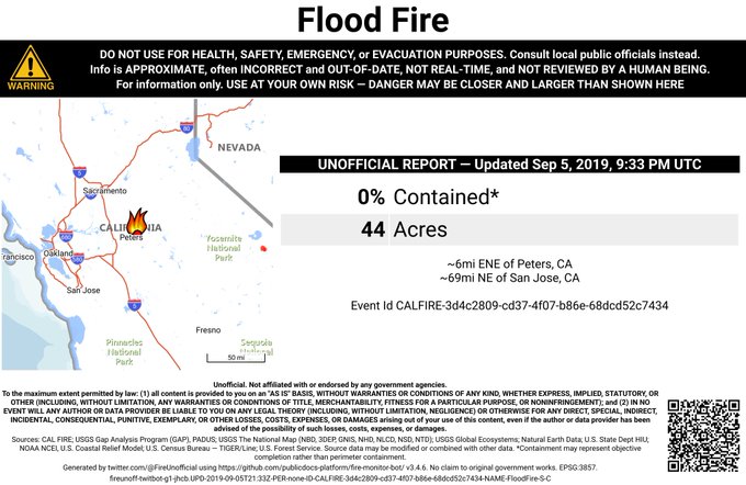
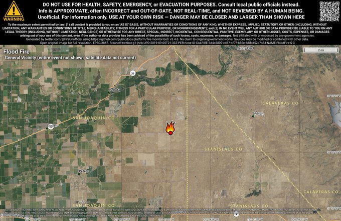
The fire is 44 acres in size and 0 percent contained, according to CA.gov on September 5, the last update for the fire.
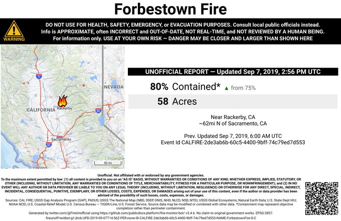
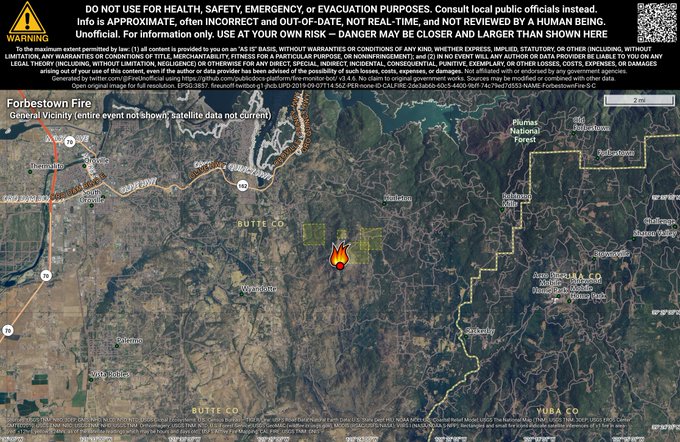
Forbestown Fire
The Forbestown Fire is 58 acres, according to Cal Fire. It’s now 80 percent contained as of September 7. No structures are damaged.
#ForbestownFire [update] As night falls over the fire, crews on the ground continue working to establish control lines and remove hazard trees. The fire remains at 58 acres and is 75 percent contained. Work will continue through the night and into tomorrow.


The fire is at Jernigan Way and Quality Lane in Forbestown.
#ForbestownFire 🔥 unofficial, automated update.
Near Rackerby, CA. ⚠️ DO NOT USE FOR SAFETY PURPOSES – See officials instead. May be incorrect; disclaimers in images.
t.co/gtrInzll8L
Forward progress has been stopped.
Henthorne Fire (1-1 Fire)
CalFireHenthorne Fire
The 1-1 Henthorne Fire is 291 acres and 10 percent contained as of September 7, according to Ca.gov. It’s located 15 miles northeast of Covelo in Mendocino county. It’s in the Yolla Bolly Middle Eel Wilderness near Henthorne Lake.
Inciweb
The cause is under investigation.
Ca.gov noted: “With the assistance of air craft, hand crews and the assistance of local government strike teams from Mendocino and Sonoma County progress was made overnight and into Friday. Continued efforts will be made throughout tonight and into tomorrow. At this time, there is no threat to structures or civilians.”
Lime Fire
Inciweb
This fire was discovered on September 4. As of September 6 at 6:58 p.m., the fire was 200 acres, according to Inciweb. It’s near Lime Gulch in the Klamath National Forest. Inciweb noted:Resources are actively engaged in stopping forward direction and in structure protection. Direct strategy is being used with backup plans for alternative strategies.”
The fire was caused by lightning. It remained small throughout the day yesterday until it started growing in the afternoon.
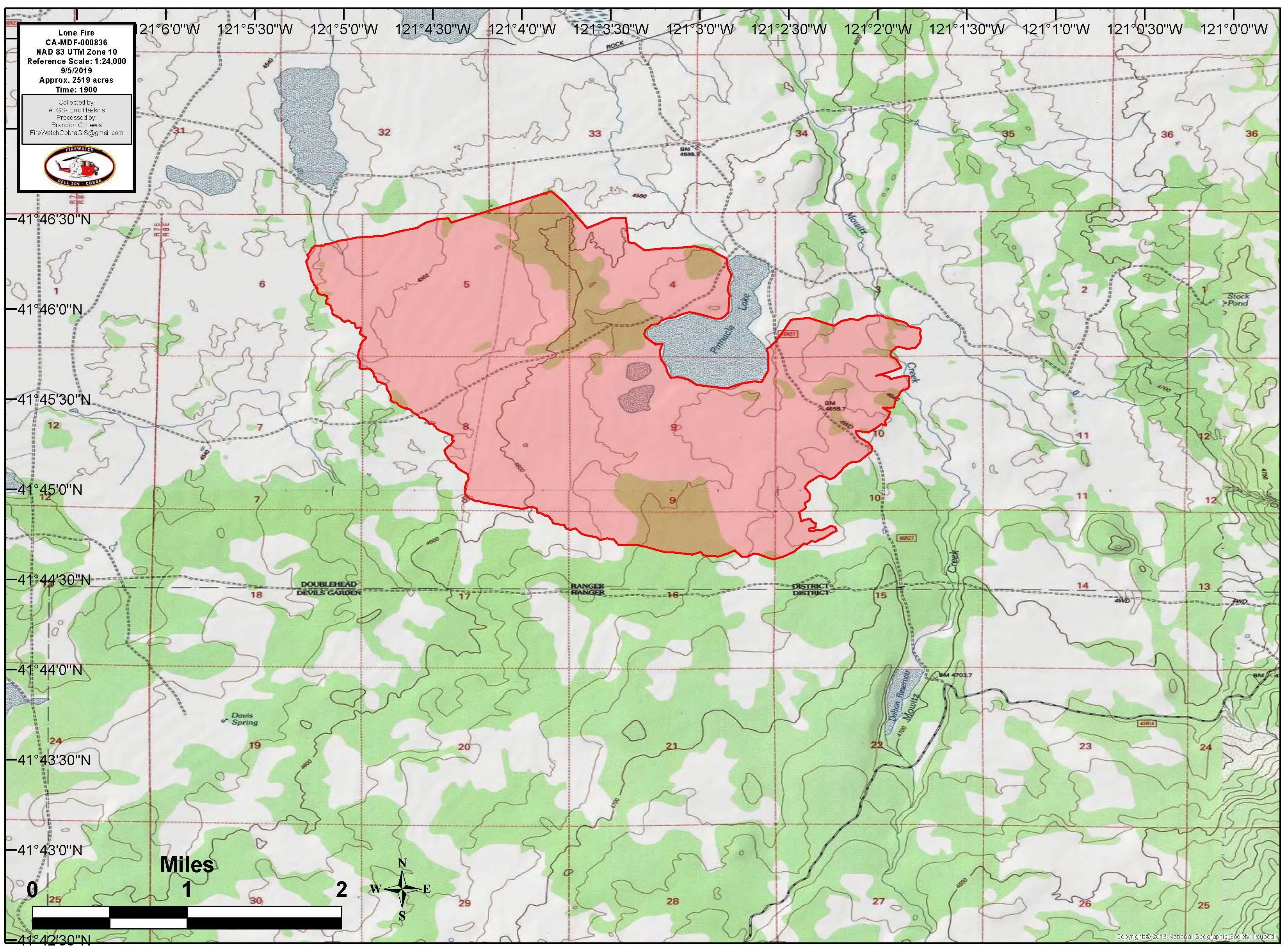
Lone Fire
Ca.govLone Fire
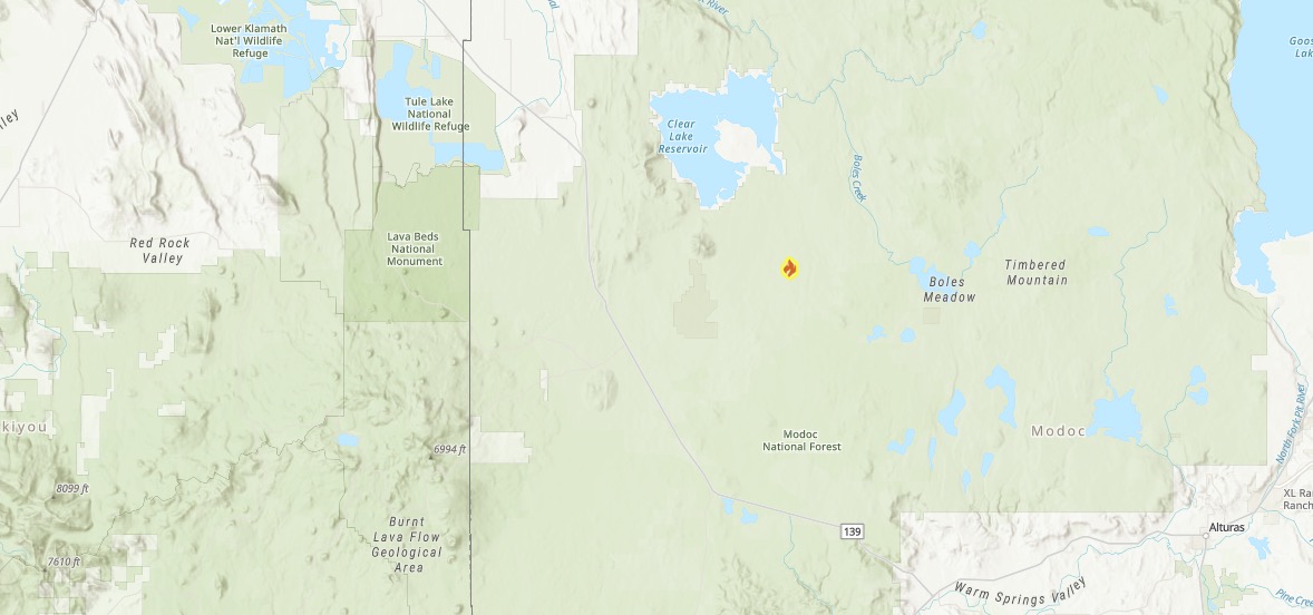
This fire was 2,592 acres and 0 percent contained on September 6, but now it’s 5,000 acres in size on September 7. It’s in Modoc National Forest in Modoc County, near Pinnacle Lake in the Doublehead Ranger district. It’s five miles southeast of Clear Lake.
The fire was caused by lightning and started on September 5. The last updated map is below, but the fire has grown since this map was released.
Inciweb
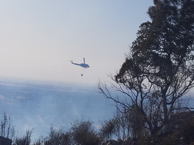
According to Inciweb, the fire was expected to grow to the east due to westerly winds. They noted on September 7 in the morning: “Overnight the Lone Fire grew to 5,000 acres. Fireline is being constructed along the fire’s edge where possible using bulldozers, engines and hand crews. Yesterday, one helicopter and several air tankers, including a DC-10 Very Large Air Tanker (VLAT), were responded and made multiple retardant drops on the fire. This lightning-caused fire is burning in grass and juniper around Pinnacle Lake and is growing primarily to the east.”
KNF Lightning Fires
Inciweb noted in its most recent update from September 6: “As of this morning, 38 fires have been confirmed in the Klamath National Forest. Most have been managed and remain small, between 1/10th of an acre to five acres. Resources are on scene or responding to all of these fires. A local type 3 incident team is being put in place for a larger fire of between 30 and 40 acres in the Oak Knoll Ranger District area. New fires may be discovered today as air resources continue to perform reconnaissance flights over the forest. We will continue to update InciWeb as needed.”
Oak Fire in Kelseyville
A new fire has emerged in California this afternoon. Details on this fire are still developing, but it’s being referred to as the Oak Fire in Kelseyville.
Ukiah Daily Journal notes that it’s on Highway 29 near Kelseyville. It’s somewhere between 10 and 20 acres in size and structures may be threatened.
Kelseyville fire at the moment. @kron4news
Details are still coming in about this fire.
R-6 Fire
#R6Fire 🔥 unofficial, automated update.
~11mi ENE of Spaulding, CA. ⚠️ DO NOT USE FOR SAFETY PURPOSES – See officials instead. May be incorrect; disclaimers in images.


This newer fire is 260 acres and 10 percent contained, Inciweb noted on September 7. It started on the afternoon of September 6. It’s in the Cleghorn area, about 22 miles northeast of Susanville, California and six miles east of Eagle Lake North Shore. Inciweb notes that the fire could spread north/northeast toward Termo and Juniper Ridge.
Inciweb noted: “There is high spotting potential and longer mop up times because of timber. The fire threatens three remote rural ranches. No structures have been damaged. The fire threatens livestock grazing areas, sage grouse habitat and timberlands.”
This fire was caused by lightning.
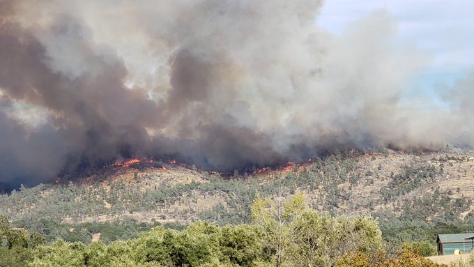
Red Bank Fire
#redbankfire looking west from Cannon Rd at 2pm
This fire was 1,000 acres and 0 percent contained on September 5, and now it’s 7,754 acres and 9 percent contained on September 7. It was first discovered on the afternoon of September 5 in Tehama County, according to Ca.gov.
It’s west of Red Bluff, off Hammer Loop Road and Petty John Road.
The following is a map of the Red Bank and the South Fire, providing by MappingSupport.com. They note: “#RedBankFire and #SouthFire west of Red Bluff, CA. Satellite hotspot data is always 3-9 hours old when you see it on a map. To learn more, click ‘Map Tips’ upper left corner.” *
It’s one of several fires in a close region. The fire is 25 miles west of Red Bluff and is threatening structures in the area, Red Bluff Daily reported. It started out as a 10-acre vegetation fire caused by lightning and quickly grew.
Some evacuations were put in place for the fire. According to CA.gov on the morning of September 7 these include:
- Mandatory evacuations: “The areas south of Highway 36 between Tedoc Road and Vestal Road, and between the Shasta-Trinity National Forest boundary and the Four Corners intersection.”
- “Evacuation Warning: The greater Red Banks Community east of Joint Road located on and from Bell Road.”
Ca.gov also noted on September 7:
The Red Bank Fire continues to burn west of Red Bluff. The fire is burning in remote, very steep, rocky terrain. Firefighters are being challenged by narrow roads and poor access into the fire area. Plans are being made to fly firefighters into the fire line to assist with containment efforts. The weather has been hot and dry with poor humidity recovery overnight. Increasing winds over the weekend could hamper containment efforts.
Motorists should drive cautiously and always yield to emergency vehicles that are traveling on and off of the roads and highways. Fire danger remains elevated and everyone should continue to use extreme caution and refrain from daily activities that may spark a wildland fire. “Ready, Set, Go” is a user-friendly website that shows homeowners step-by-step instructions for hardening their homes and protecting their families from the dangers of wildfires. For more information, visit www.readyforwildfire.org.”
There are no road closures currently in place, as of Saturday morning.
Although Tehama County Deputy Sheriff’s Association’s Facebook page has been providing updates at first, they are now directing people to CalFire’s website here. Cal Fire Tehama-Glenn Unit is also sharing some updates on Facebook here.
You can also stay updated via Tehama’s Alert App.
Riverside, California Fire in Sycamore Canyon Park
A fire has also been reported this afternoon in Riverside, California. The fire’s in Sycamore Canyon Park, PE reported, near Via Zapata and Verdugo.
The fire is about 40 acres in size and residents are asked to stay away from the area.
SHF Lightning Fires 2019
Here are the latest updates on lightning fires in the region of 41.063 latitude, -122.638 longitude, according to Inciweb. The list below is a direct quote from Inciweb’s page on September 7.
South Fork Management Unit (Hayfork and Platina area)
09/05/2019 7:11, LITTLE, Yolla Bolla Wilderness, 0.25 acre, Patrol status
09/05/2019 7:14, FORK, southwest of Platina west of Tedoc, 0.25 acre, staffed
09/05/2019 8:57, LOVE, north of Hayfork near Love Letter Springs, 0.3 acre, crews hiking in
09/05/2019 9:34, NATURAL, near Natural Bridge > CAL FIRE SHU direct protection area
09/05/2019 1:50, SOUTH, SE of Tomhead MTN, 1200 acres
Trinity River Management Unit (Weaverville, Big Bar, Trinity Lake, Trinity Alps)
09/05/2019 7:09, EAST, Halls Gulch NE of Trinity Lake, 0.25 acres, staffed
09/05/2019 7:22, LADY, Lady Gulch Trinity Alps Wilderness, 1 acre, staffed
09/05/2019 7:25, LICK, east of Trinity Lake, unable to locate
09/05/2019 8:16, CEMENT, east of Trinity Lake, unable to locate
09/05/2019 8:18, FOOL, west of Trinity Lake, 0.1 acres, CONTAINED
09/05/2019 8:20, QUARTZ, west of Trinity Lake, unable To locate
09/05/2019 8:23, SLATE, west of Trinity Lake, 2 acres, CONTAINED
09/05/2019 9:07, MIDDLE, NE of Canyon Creek Trailhead, 20 acres, staffed
09/05/2019 10:13, EASTMAN, south of Tunnel Rock .25 acres, CONTAINED
09/05/2019 10:38, WAGNER, Billy’s Peak west of Trinity Lake, 0.1 acres, staffed
09/05/2019 10:44, HATCHET, east of Poison Canyon .5 acres, CONTAINED
09/05/2019 11;15, JAKES, Jakes Upper Camp, 0.1 acres, staffed
09/05/2019 12:18, RANCH, located above Rancheria Creek, 0.2 acres, CONTAINED
09/05/2019 12:56, CUTTHROAT, west of Cutthroat Gulch, 15 acres staffed
09/05/2019 2:29, IRISH, Jackass Springs, 0.1 acres, CONTAINED
09/05/2019 2:53, SWIFT, NW of Trinity Center, CONTAINED
09/05/2019 4:50, HOBEL, SW of Trinity Center
09/05/2019 5:39, RAMSHORN, Ramshorn Creek north of Bonanza King Mtn., 0.1 acres
09/06/2019 10:14, HORSESHOE, Horseshoe Lake, 0.1 acres
09/06/2019 12:34, LAKE, Toad Lake, 0.1 acres
Shasta Lake Ranger District and the National Recreation Area (Shasta Lake)
No fires detected
Shasta McCloud Management Unit (Mt Shasta and McCloud area)
09/05/2019 5:21, HERE, east of Hwy3, West of Castle Crags, 5.4 acres, staffed
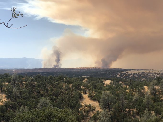
South Fire
#SouthFire 🔥 unofficial, automated update.
@ShastaTrinityNF; ~20mi WNW of Rancho Tehama Reserve, CA. ⚠️ DO NOT USE FOR SAFETY PURPOSES – See officials instead. May be incorrect; disclaimers in images.

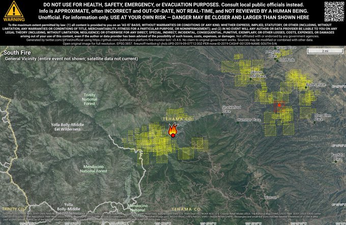
The South Fire started in Shasta-Trinity National Forest in Tehama County. Earlier on September 6 it was reported to be 200 acres and 0 percent contained. As of the morning of September 7, the fire is now 1,665 acres in size according to Inciweb.
The fire is 15 miles south of Platina, California. It’s anticipated to spread down-canyon to the east and northeast.
The fire is south of Platina in the “southeast aspect of Tomhead Mountain.”
The following is a map of the Red Bank and the South Fire, providing by MappingSupport.com. They note: “#RedBankFire and #SouthFire west of Red Bluff, CA. Satellite hotspot data is always 3-9 hours old when you see it on a map. To learn more, click ‘Map Tips’ upper left corner.”
The fire is burning south and west of the Red Bank Fire, Red Bluff Daily News noted. Both fires are causing a lot of smoke today in the valley.
Springs Fire
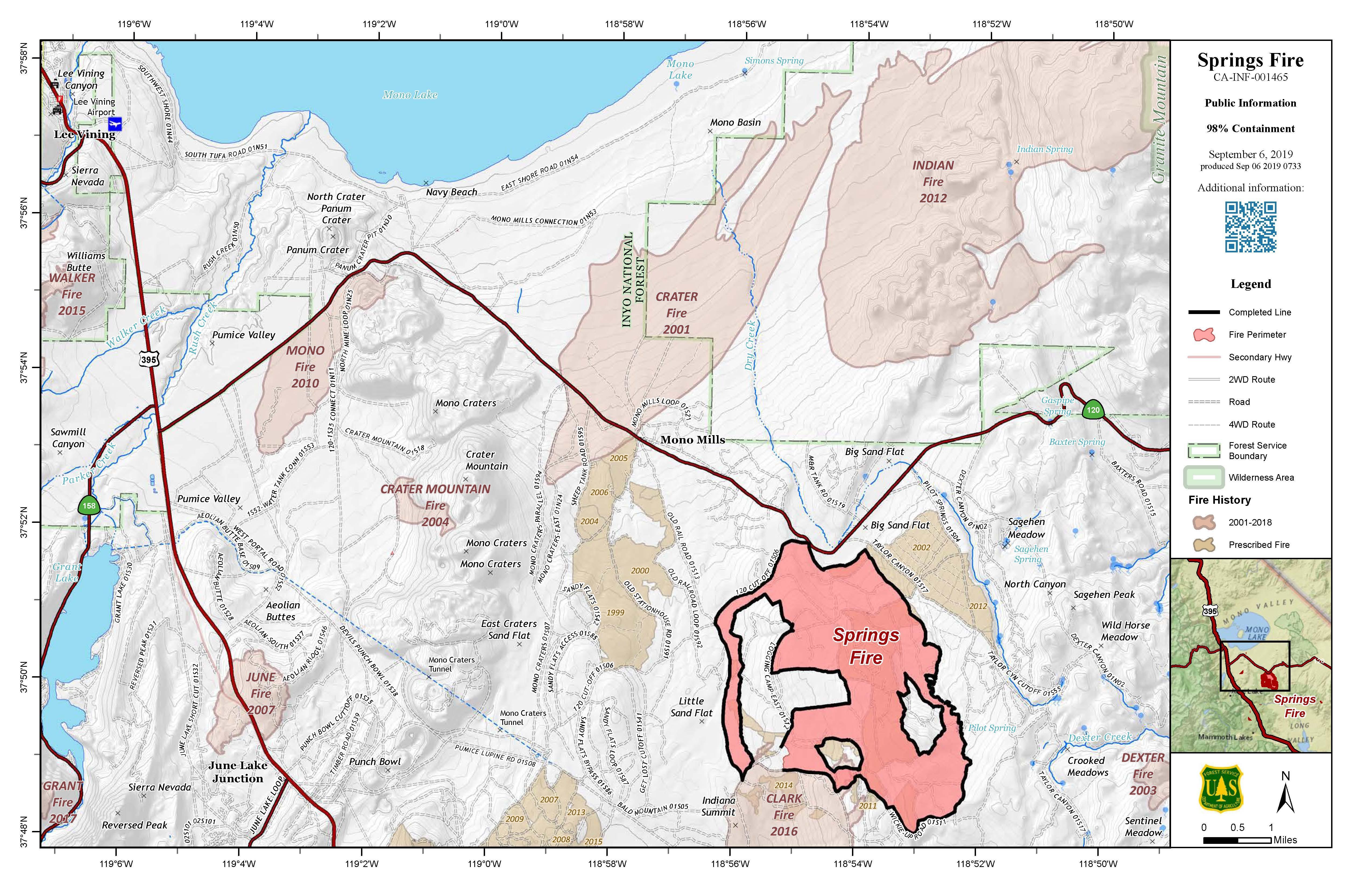
Inciweb
This fire is now 4,840 acres and 98 percent contained according to Ca.gov on September 6 and Inciweb on September 7. It was caused by lightning. It’s located 13 miles southeast of Lee Vining.
Inciweb noted on September 7: “With containment up to 98 percent, the shift has been made to full rehabilitation and repair of the Springs Fire. The same crews that worked on suppressing the fire now shift gears to suppression repair. Crews work closely with advisors specialized in the protection of natural, cultural, and special management areas when performing suppression repair; these individuals are known as resource advisors. These resource advisors provide professional knowledge and expertise in fields such as wildlife biology, forestry, heritage preservation, hydrology, and many more. These coordinated efforts make for a healthier forest. Fire managers have additional safety plans for the fire’s operations to ensure minimum impact to the Mammoth Gran Fondo race today and the Tioga Pass Run tomorrow. Please drive with care through these areas.”
Swedes Fire
#SwedesFire Swedes Flat Road and Oro Bangor Highway, east of Oroville in Butte County is 200 acres.
t.co/jBh7Rim5k6

The Swedes Fire is near Swedes Flat Road and Oro Bangor Highway in Butte County, east of Oroville. It’s now 300 acres in size.
EVACUATION ORDER
#SwedesFire
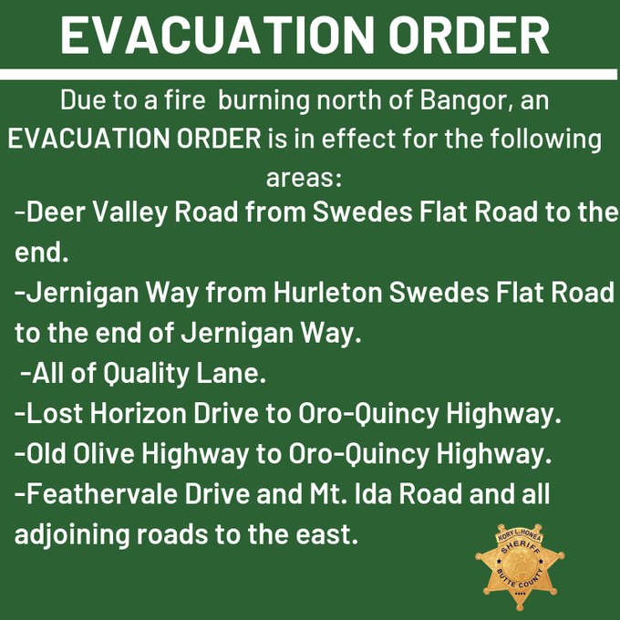
Some evacuations are already in place, per the Butte County Sheriff’s office. An evacuation order is in effect for:
- Deer Valley Road from Swedes Flat Road to the end
- Jernigan Way from Hurleton Swedes Flad Road to the end of Jernigan Way
- All of Quality Lane
- Lost Horizon Drive to Oro-Quincy Highway
- Old Olive Highway to Oro-Quincy Highway
- Feathervale Drive and Mt. Ida Road and all adjoining roads to the east.
As of 6 p.m. Pacific, Butte County’s web page’s Emergency Update window had a map indicating evacuations orders that you can view on their home page, or that you will receive if you sign up for their Code Red warning. This is what the map looks like, but you’ll get a better view of it if you sign up for Code Red.
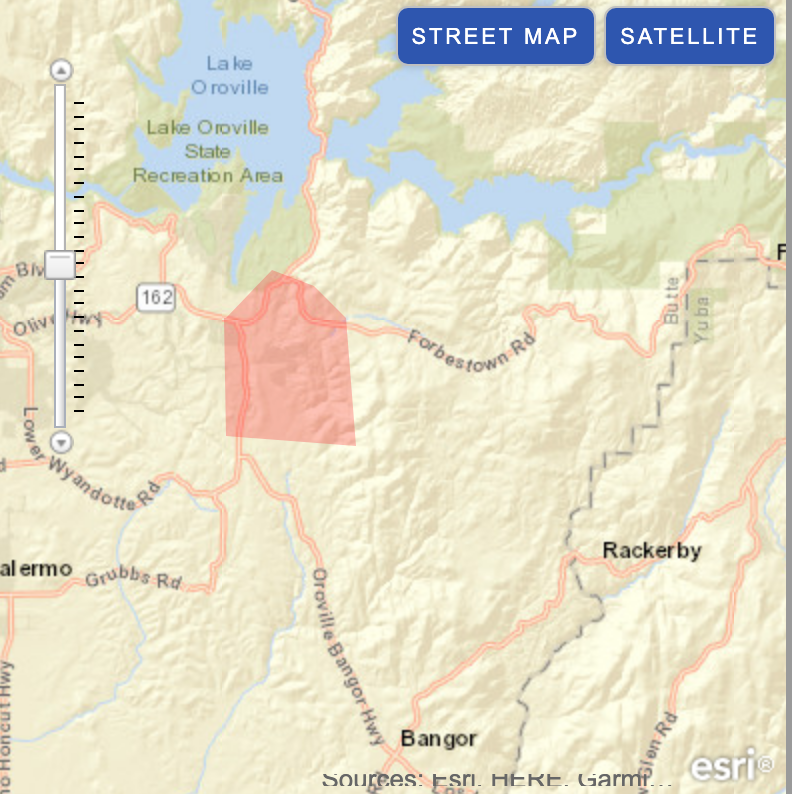
Butte Countyac
There are also evacuation warnings in effect.
EVACUATION WARNING
#SwedesFire
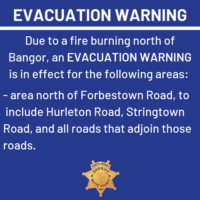
An evacuation warning is in effect for the area north of Forbestown Road, to include Hurleton Road, Stringtown Road, and all roads that adjoin those roads, according to the Butte County Sheriff’s Office.
#SwedesFire #ButteCo
#NVADG has been activated. I will update with animal shelter information as soon I get it.
Stay updated on emergency alerts and more by signing up here. You can also follow the Butte County Sheriff’s Twitter page for details. Evacuation details can change quickly, so stay tuned to these sources for the latest updates.
#SwedesFire [update] Now 300 acres. We have set up an information phone line. Call 530-538-7826 for the latest fire information. Please do not call 9-1-1 for fire information.
You can also stay updated by calling 530-538-7826 (the information line for the fire.)
Taboose Fire
#TabooseFire 🔥 unofficial, automated update.
@InyoInfo; ~10mi S of Big Pine, CA. ⚠️ DO NOT USE FOR SAFETY PURPOSES – See officials instead. May be incorrect; disclaimers in images.

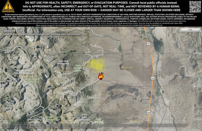
This fire is 354 acres and 80 percent contained as of September 7, according to Inciweb. It’s southwest of Big Pine and northwest of Aberdeen.
Inciweb said on Sept. 7: “Today, crews continue to patrol containment lines and check for hot spots. Erratic winds and thunderstorms remain in the forecast. All pre-evacuation advisories have been lifted. Fire crews will continue to use Tinnemaha Campground for their operations through the weekend. However, incident managers have begun releasing firefighters from this incident.”
Tenaja Fire
The Tenaja Fire is listed on Ca.gov’s map. It’s 2,000 acres in size and 35 percent contained, according to CA.gov and Cal Fire. That’s up and additional 5 percent or more from the day before with little new growth, so that’s a good sign. But it’s still too soon to let your guard down if you’re in the region.
The fire started near Tenaja Road and Clinton Keith Road in La Cresta on the afternoon of September 4. Below is an approximate location for where the fire started. It does not indicate the fire’s size, which is nearly 2,000 acres.
The fire started at 4:43 p.m. on September 4, according to the California Department of Forestry & Fire Protection, and then quickly grew in just a few hours to 994 acres in Riverside County. Now it’s 2,000 acres in size.
Here’s a map of evacuation orders that’s being updated by the County of Riverside. Yellow indicates voluntary evacuations and red indicates mandatory evacuations. Right now nothing is shaded because at this time, all evacuation warnings were lifted the evening of September 6, per RVCFire.org. Use the + icon to zoom into the map, which may be necessary depending on the browser you’re using.
You can visit the full-sized map here.
You can stay updated on the fire through the incident information page here.
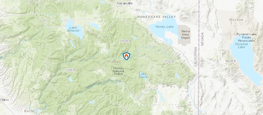
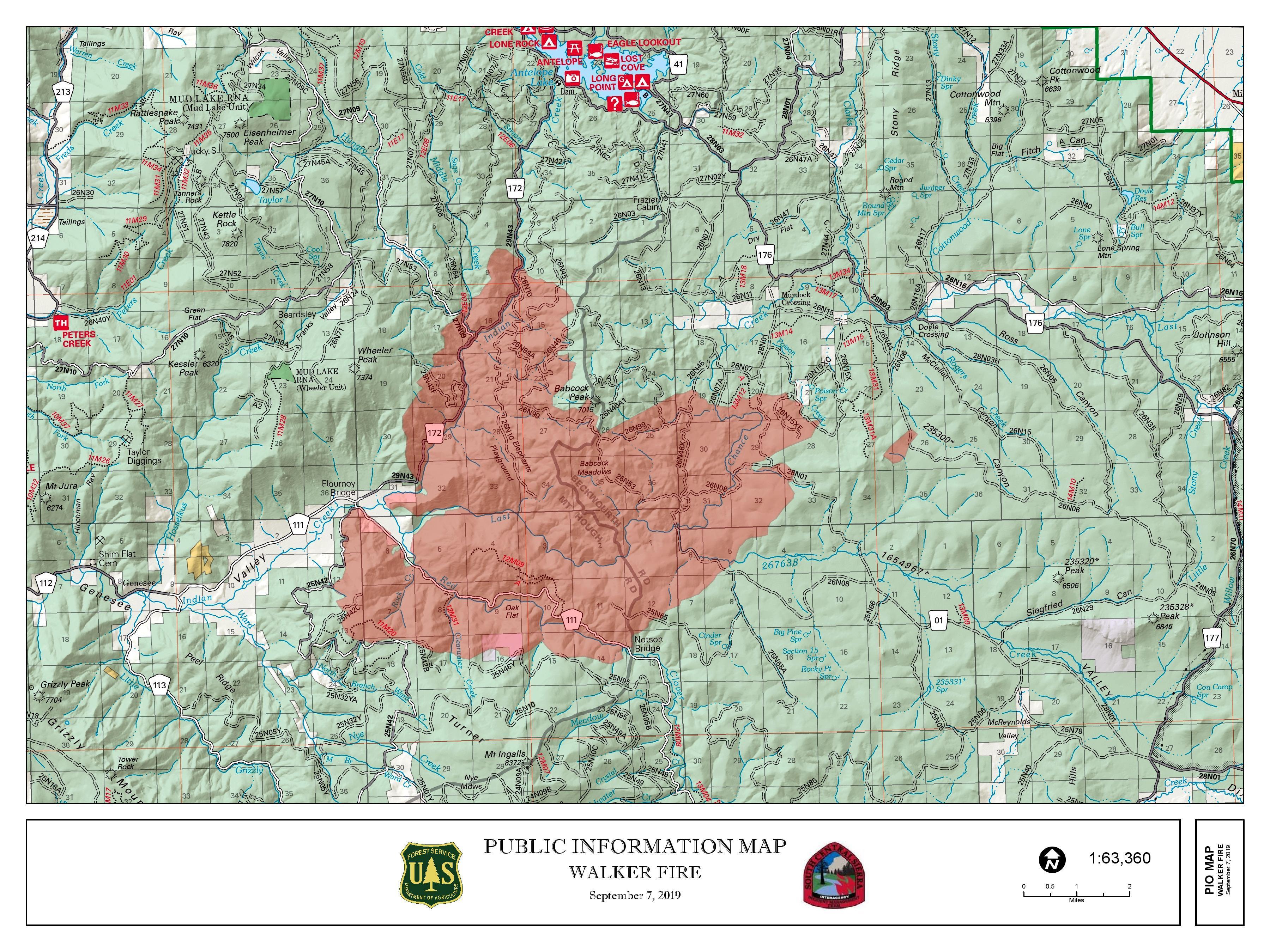
Walker Fire
Inciweb
This fire was first reported on September 4 and the cause isn’t known. Ca.gov noted that it’s 2,000 acres and 0 percent contained as of September 6. But on September 7, that number skyrocketed. According to Inciweb on the morning of September 7, the fire is now 24,040 acres in size. It’s 0 percent contained.
Inciweb
It’s located east of Genesee near Indian Creek and Beckworth Genesee Road.
The Walker Fire is producing a lot of smoke.
Here’s an interactive map of the Walker Fire by MappingSupport.com. They note: “Saturday 9/7 #WalkerFire CA 24,040 acres per 9:38pm infrared flight yesterday + analysis by fire staff. Map has lots of #GIS layers you can turn on/off/restack. Need help using the map? Click ‘Map tips’ upper left corner. #CAfire.”
According to Inciweb, the fire is burning on the Plumas National Forest about 11 miles east of Taylorsville. As winds pushed the fire to the east-southeast, more evacuations were issued.
Here are evacuation details:
- “The Plumas County Sherriff’s Office ordered mandatory evacuations for the Genesee Valley road corridor, the Ward Creek area, and the Flournoy Bridge area (through CodeRED),” Inciweb noted.
- Yubanet.com noted on the morning of September 7: “Mandatory evacuations in place along the Antelope Lake Rd. from Heart K Ranch to Babcock Meadows. Evacuation advisory has been issued for the Babcock Crossing area. Threat to 5 Bears Hydroelectric project in Ward Creek.”
- “Residents who need accommodations should proceed to the Quincy area and contact the Sheriff’s Office.”
Here are road closure details from Inciweb:
- The Genesee Valley road is closed at the Flournoy Bridge.
- Antelope road is also closed from the Flournoy Bridge to Antelope Dam.
Inciweb wrote on September 7: “Last night the fire activity decreased, slowly backing down towards the 25N42 road where firefighters were able to engage and hold the fire east of the 25N42 road. The fire progressed to the northeast to area of Babcock Peak. Today more ground and air resources, including VLATs (Very Large Air Tankers), will aid in the fire suppression effort. Crews will be constructing containment line along the edge of the fire where possible and continue to secure the southwestern portion of the fire. Structure preparation will occur in the Murdock Crossing area. Aerial resources will be used to slow fire’s forward progression while ground crews look for opportunities to contain the fire to the northeast. No structures have been lost.”
If you’re in Plumas County, you can sign up for emergency notices here. Or call 530-616-8625 for updates.
READ NEXT: WATCH: Man with TV on Head Leaves CRT TVs on Porches in Virginia