Inciweb
New fires are being reported in California almost every day, as other large fires continue to bring trouble. The Walker Fire is still burning, but there are many other fires causing issues in the state too. Here’s a look at the latest wildfires being reported on September 9, 2019. This article first includes interactive maps for all of California, including Cal Fire and other sources. Then the second section details specific fires in the region in alphabetical order. Remember that when it comes to fires, details such as evacuations can change quickly, so stay tuned to your local news sources. This story will provide links for where updates will be posted for each individual fire, when available.
Interactive Maps of California Fires
Here are interactive maps you can follow to get the best updates about California fires in September. In many cases, the fires don’t always overlap on these maps, so it’s good to review all of them for the latest information.
One of the best interactive maps available right now is Inciweb’s map. You can see the full map here. There’s an embeddable Google Map that includes Inciweb fires which you can see below. Depending on your browser, you may need to zoom in using the + button within the map or change settings to only show Inciweb fires:
Another good map can be found here from Ca.gov. A screenshot is below since the map can’t be embedded, but you’ll want to go to the full map for details. You can input your address to see how close the fires are to your location.
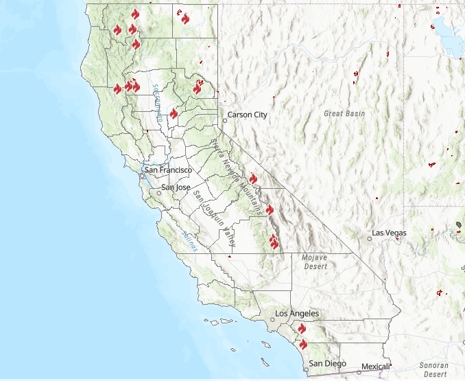
Ca.gov
Remember: brand new fires may not be listed on the above maps until they’ve been around for a few hours.
A new interactive fire map is below, provided by UCANR.edu. Note that this map is only updated up to twice daily, so it may not be not as current as the two interactive maps above.
Next are more specific details on the fires for September 9, 2019. If you are looking for a specific fire, search for the name so you can find it faster, or just scroll down and look at the fires, listed in alphabetical order.
List of Active Fires in California on September 9, 2019
Here are the active fires and updates about them. Most of these are in alphabetical order.
Atwater Fire
#BreakingNews Fire alongside Highway 99 just north of Applegate Rd in Atwater. There’s a homeless encampment in that spot.

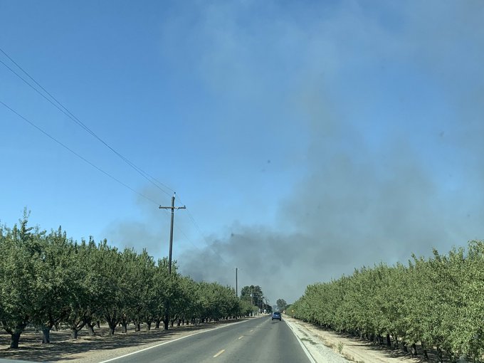
A fire in Atwater was reported along Highway 99 north of Applegate Road, near a homeless encampment.
Broder Fire
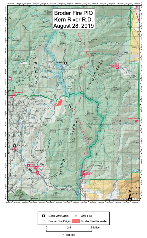
InciwebBroder Fire
This fire is 370 acres in size and 30 percent contained as of September 5, the last update from Inciweb It was started by lightning on August 8. It’s northeast of Broder Meadow and crews are using natural barriers to fight the fire, Inciweb noted in its most recent update.
Monache Meadows is open to recreationists, but use caution. The fire’s burning at a moderate rate of speed, Inciweb noted, and there may still be smoke in the region.
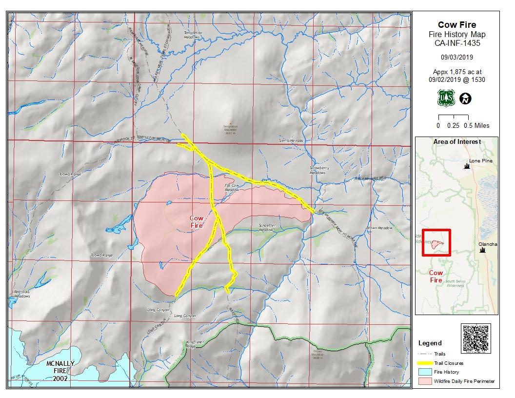
Cow Fire
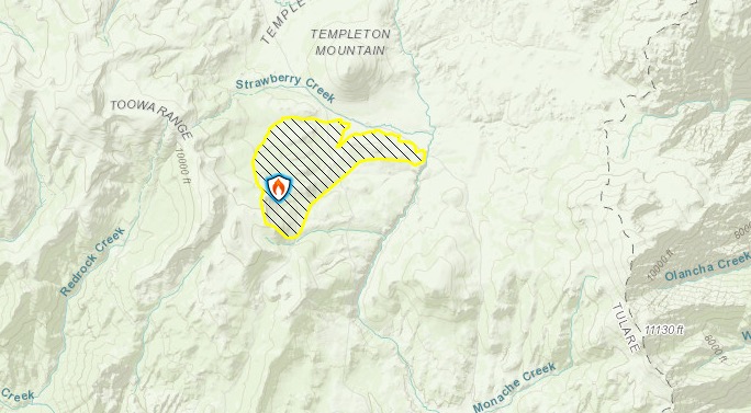
Inciweb
This fire is 1,975 acres in size and 30 percent contained, Inciweb noted on September 7, which is the latest update. It was started by lightning on July 25 and is nearly 2,000 acres in size as of September 4. The map below is the last map released by Inciweb for the fire.
Inciweb
The fire’s burning in the Golden Trout Wilderness on Inyo National Forest. The fire’s being successfully confined and suppressed. Inciweb released its final update on the fire on September 7. They wrote:
The 1,975-acre Cow Fire remains 30 percent contained. Minimal smoke may be visible from the Cow Fire until the area receives significant rainfall. Firefighters will continue to monitor the fire to ensure it stays within control lines. Containment will steadily increase as crews further secure control lines by identifying and extinguishing sources of heat along the fire perimeter.
The ecosystem within the Cow Fire footprint will benefit from the low-intensity fire effects observed on the landscape. Lightning-caused wildfires have a natural role to play in Eastern Sierra forest ecosystems. Burned materials recycle nutrients back into the soil which enriches it and stimulates vegetation growth. New grasses, shrubs and trees replenish and grow stronger while old growth stands become more resilient. Wildlife habitats are created and an increase in food becomes available for animals to forage. The hazardous accumulation of logs and overgrown surface fuels on the forest floor are reduced which diminishes the risk of severe wildfires in the future. Heat from fire opens the strong resin which holds seeds inside of the serotinous cones of Lodgepole Pine, allowing the species to reproduce.
The public is encouraged to avoid the fire area. Post-fire hazardous such as fire weakened trees and burning stump holes may be present.”
September 7 was the final Inciweb update for the fire due to good suppression efforts.
Duzel Fire
This fire is located northeast of Etna near Duzel Rock Lookout in Siskiyou County. It’s 15 acres and 70 percent contained as of September 9. The cause is under investigation, according to Ca.gov.
Fork Fire
This fire started on September 8 in the early evening, caused by lightning. It’s at Middle Fork Parker Creek, in South Warner Wilderness. The fire is currently 12 acres in size.
Inciweb noted on September 9:
The Fork Fire, burning in a remote area of the South Warner Wilderness, has grown to 12 acres. Firefighters and resource advisors are on scene managing the Fork Fire as it slowly consumes dead and downed trees… The fire has provided an opportunity to allow these dense concentrations of fuels to be consumed under much more favorable conditions. Modoc National Forest leadership is working closely with personnel on scene as the operation continues. The first consideration of all decisions made regarding the fire is firefighter and public safety, followed by impact on the wilderness character.”
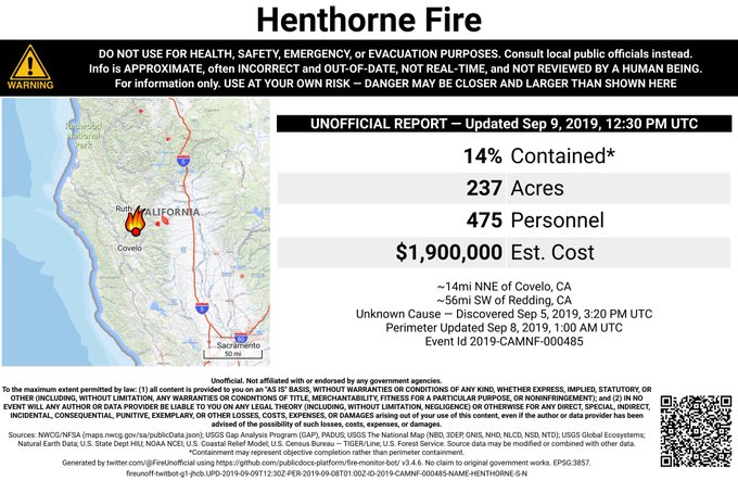
Henthorne Fire (1-1 Fire)
CalFireHenthorne Fire
The Henthorne Fire has grown from 237 acres and 14 percent contained as of September 9, according to Inciweb. It’s located 15 miles northeast of Covelo in Mendocino County, according to Ca.gov. It’s in the Yolla Bolly Middle Eel Wilderness near Henthorne Lake.
#HenthorneFire 🔥 unofficial, automated update.
@MendocinoNF; ~14mi NNE of Covelo, CA. ⚠️ DO NOT USE FOR SAFETY PURPOSES – See officials instead. May be incorrect; disclaimers in images.

Here’s an infrared map:

The cause is under investigation.
Kidder 2 Fire
This fire is 107 acres and was caused by lightning. It’s in the Marble Mountain Wilderness.
Inciweb noted that plans include: “Continue to build the perimeter line around the fire and keep it out of the private timber lands. Providing for firefighter and public safety including recreational users in and around the Pacific Crest Trail.” Cooler weather will help limit the fire’s activity over the next day or two.
A community meeting for the Kidder 2 Fire is taking place on September 9 at 6:30 p.m. at the Northern California Resource Center (The Rec) at 11236 N State Highway 3 in Fort Jones, California.
KNF Lightning Fires
Inciweb noted in its most recent update from September 8: “Approximately 40 fires have been confirmed in the Klamath National Forest from the storms on Wednesday night and Thursday. Most have been managed and remain small, between 1/10th of an acre to five acres. Resources are on scene or responding to all of these fires. Additional information for two larger fires, the Lime on the Happy Camp/Oak Knoll District and the Kidder 2 on the Salmon/Scott District are being updated on InciWeb separately on their own pages. We will continue to update InciWeb as new information is available.”
Lime Fire
Inciweb
This fire was discovered on September 4. As of September 9 at 10 a.m., the fire was 1,100 acres, according to Inciweb. (Up from 200 acres on September 4.) It’s near Lime Gulch in the Klamath National Forest, west of I-5, north of Highway 96.
An update of the fire is below:
Inciweb noted on September 9: “Resources are actively engaged in stopping forward movement and in structure protection. Direct strategy is being used with backup plans being formulated for alternative strategies. Currently 6 crews, 9 dozers, 3 helicopters are on the incident. We are working in tandem with CalFire and other agencies. Siskiyou County Sheriff’s Office has ordered an evacuation warning between Road 47N15 along Ash Creek south to Hwy 96, along Hwy 96 west to Gottville, and north along 47N24 for 3 1/2 miles.”
The fire was caused by lightning.
Some areas are under an evacuation warning.
A community meeting is scheduled for Monday, September 9 at 6 p.m. in the Klamath River Community Hall at 19716 Highway 96.
Near the Lime Fire is another fire that Inciweb is calling the “Collier Fire.” This is under patrol status and not currently active.
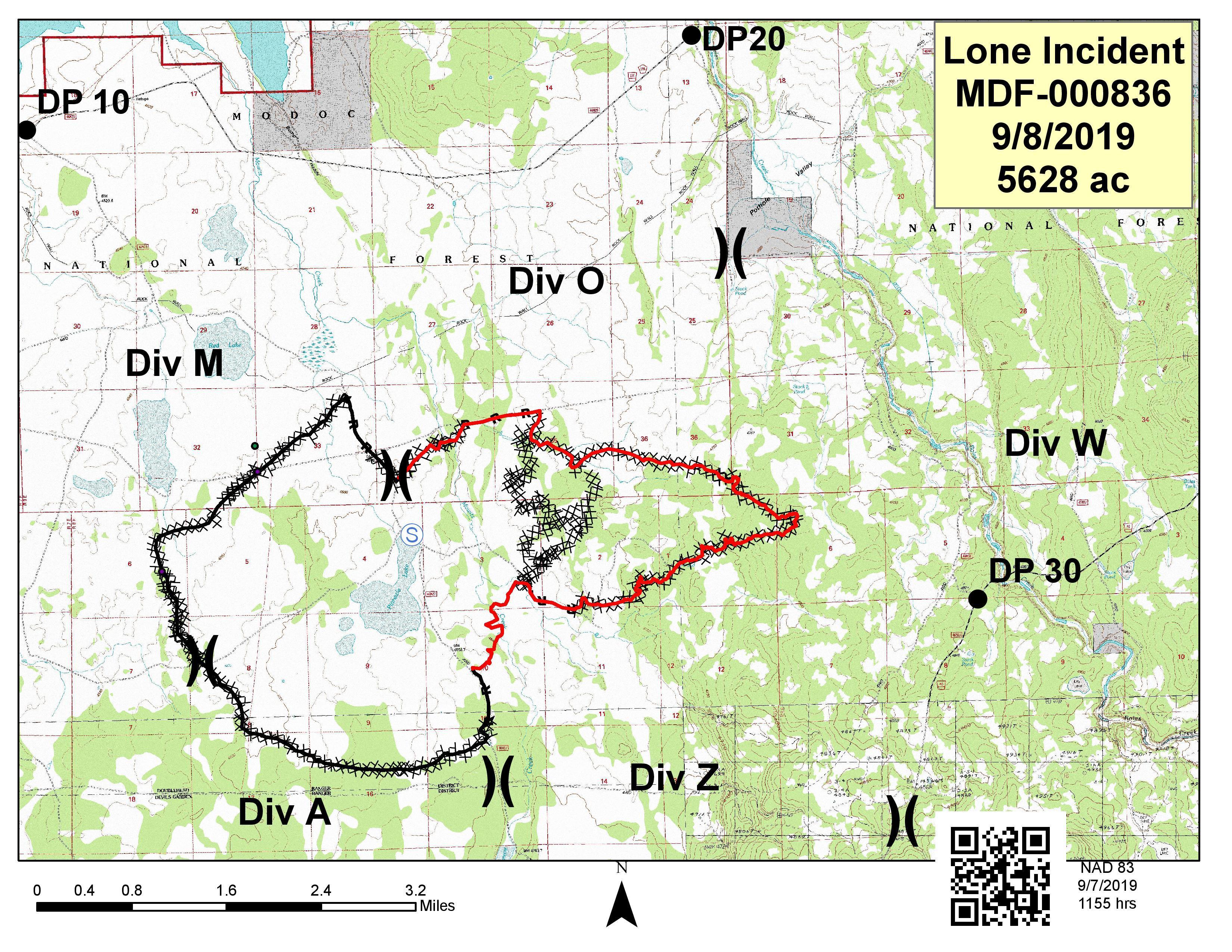
Lone Fire
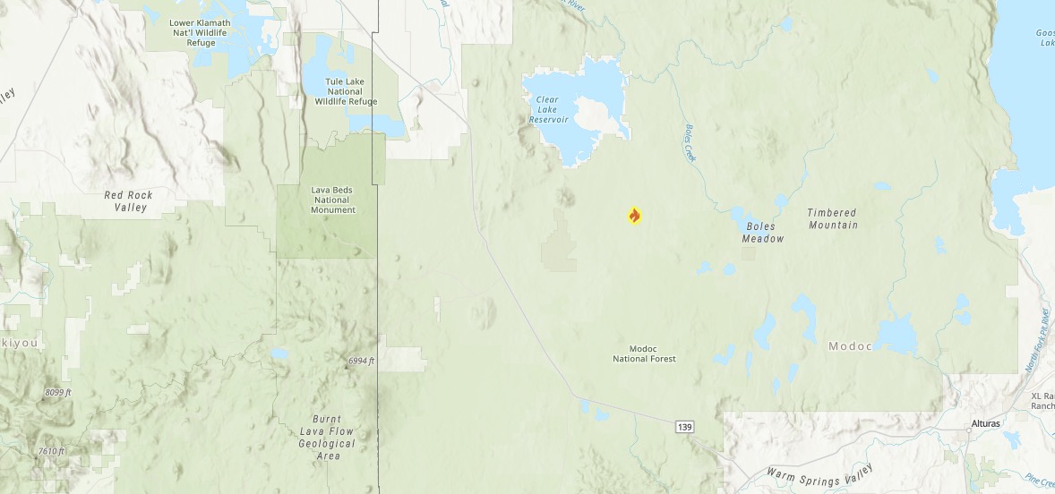
Ca.govLone Fire
This fire is 5,737 acres and 55 percent contained as of September 9, which is a big increase in containment. It’s in Modoc National Forest in Modoc County, near Pinnacle Lake in the Doublehead Ranger district. It’s five miles southeast of Clear Lake. The fire started from lightning.
Inciweb
According to Inciweb: “Firefighters will continue patrolling and reinforcing containment line by extinguishing any hot spots found near the line.”
It’s moving toward full containment. Inciweb noted on September 9: “Fire behavior has been minimal on the Lone Fire allowing firefighters to make good progress toward full containment. Today firefighters will continue to patrol the fire area, extinguish hot spots and improve containment line. Though temperatures have decreased and relative humidity has increased, the potential for spot fires across the line still exists. The primary concern is that higher winds accompanying a low pressure system may blow embers across the line into unburned vegetation. Resources are available for a rapid attack should spot fires occur. The fire is projected to be fully contained Sept. 12, 2019.”
McMurray Fire in Buellton
A fire in Santa Barbara County started on the afternoon of September 9. It’s called the McMurray Fire and it’s in Buellton on 101 past 246, near Jonata Park Road.
Multiple fires are burning in the area.
#VegetationFire– #McMurray Fire 4 separate fires burning north of Buellton. IC reports potential for 700 acres. C/T 3:18 Multiple tankers ordered.

Highway 101 northbound lanes were closed between 246 and 154, KEYT reported. Several structures may be threatened.
Middle Fire
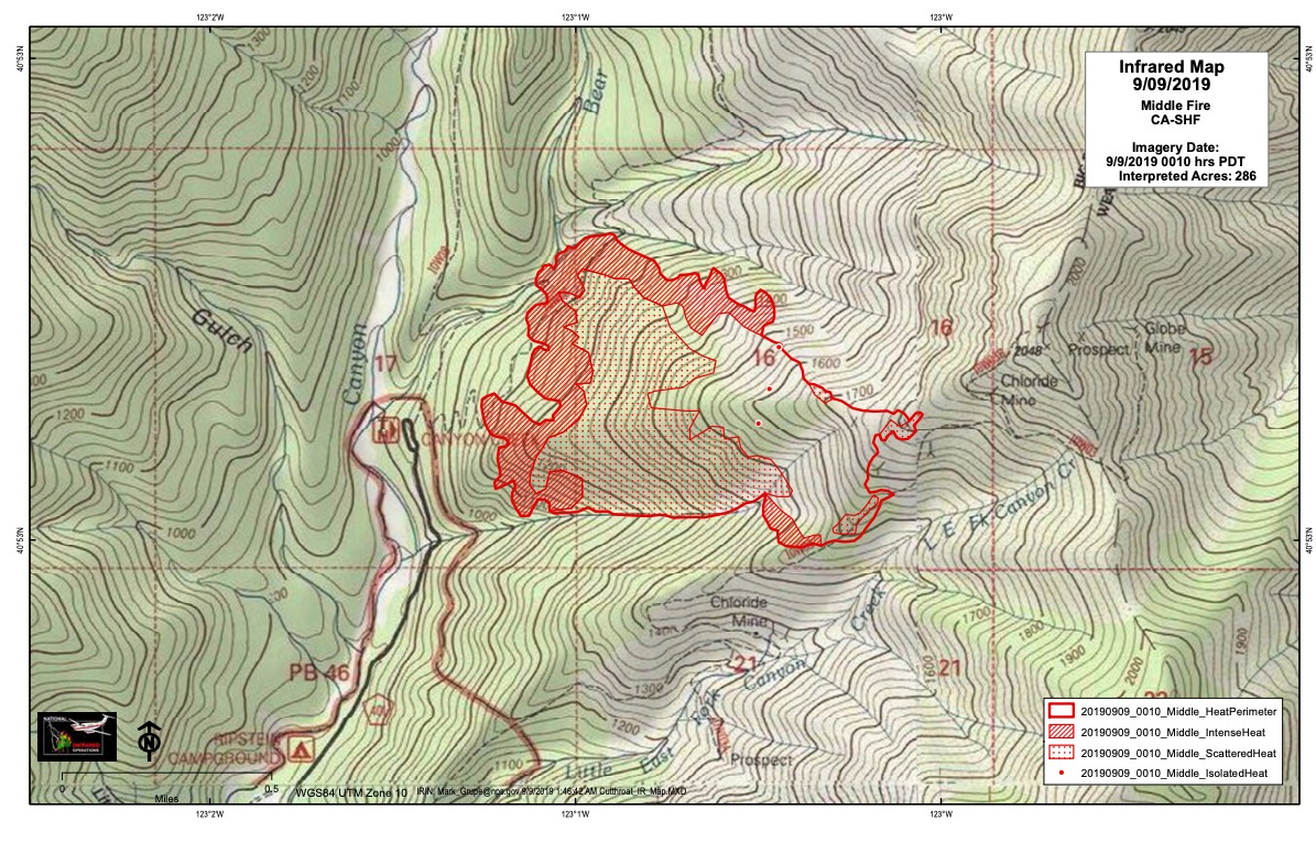
Inciweb
The Middle Fire is 286 acres as of September 9 and located one mile east of Canyon Creek Trailhead. It was caused by lightning. It started on September 5 and is in the Trinity Alps Wilderness.
#MiddleFire 🔥 unofficial, automated update.
~10mi E of Weed, NM. ⚠️ DO NOT USE FOR SAFETY PURPOSES – See officials instead. May be incorrect; disclaimers in images.

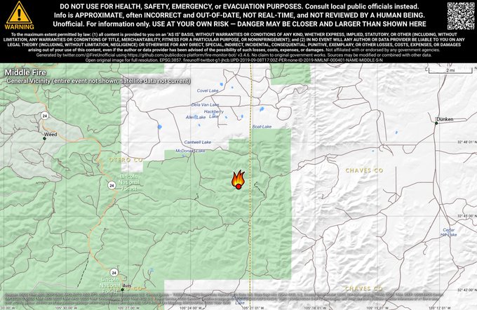
Inciweb noted: “It has grown to approximately 286 areas and is impacting the Canyon Creek and Bear Creek trails. Hikers and horse riders are encouraged to avoid the area. The fire is located approximately mid-slope and is burning downhill into the Canyon Creek and Black Bear Creek drainages. This fire is challenging because of the steep, rugged terrain and firefighters are scouting line and making plans for the best way to confine the fire. Two firefighters were injured on the Middle Fire during initial attack. Keeping firefighters and the public safe is our number one priority.”
R-6 Fire
#R6Fire 🔥 unofficial, automated update.
~11mi ENE of Spaulding, CA. ⚠️ DO NOT USE FOR SAFETY PURPOSES – See officials instead. May be incorrect; disclaimers in images.

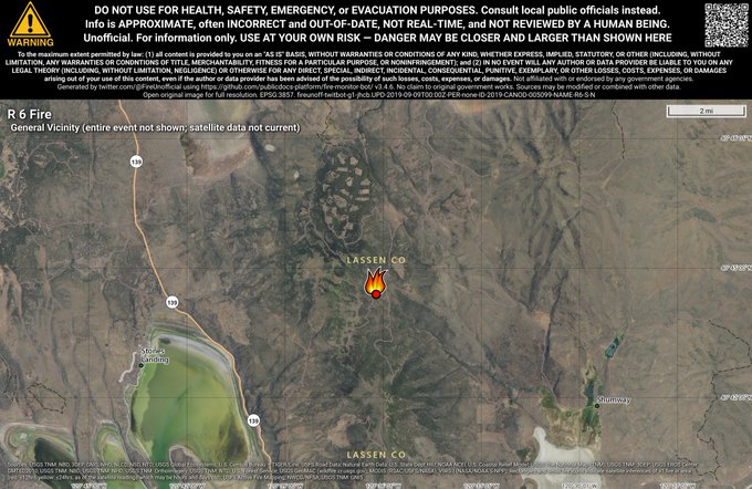
This fire is 260 acres and 60 percent contained, Inciweb noted on September 8 in the late evening. It started on the afternoon of September 6. It’s in the Cleghorn area, about 22 miles northeast of Susanville, California and six miles east of Eagle Lake North Shore. Inciweb notes that the fire could spread north/northeast toward Termo and Juniper Ridge.
Inciweb noted: “This fire is burning sagebrush, timber and range grasses about 22 miles north of Susanville, Calif. The fire is about six miles northeast of Eagle Lake’s north shore and about 11 miles southeast of Termo, Calif. No structures have been damaged. Lightning sparked this fire in the early afternoon of Friday, Sept. 6.”
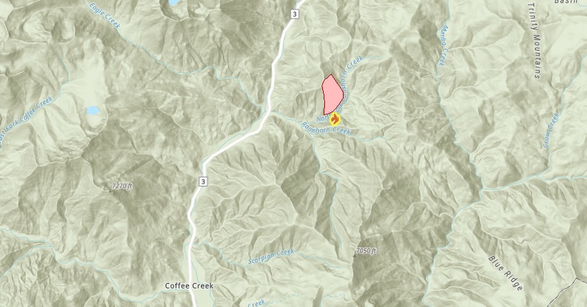
Rams Horn Fire
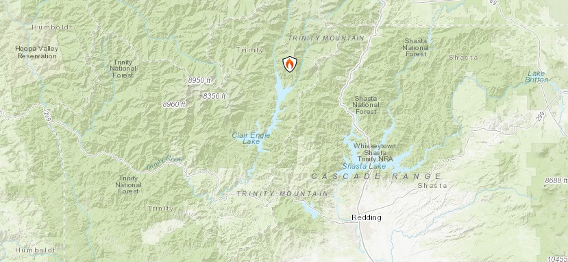
This fire is 0 percent contained and 238 acres, according to Ca.gov as of September 9. It’s in the Shasta-Trinity National Forest in Trinity County, northeast of Coffee Creek.
CA.gov
The fire is near Highway 3 and Bear Creek Loop.
Red Bank Fire
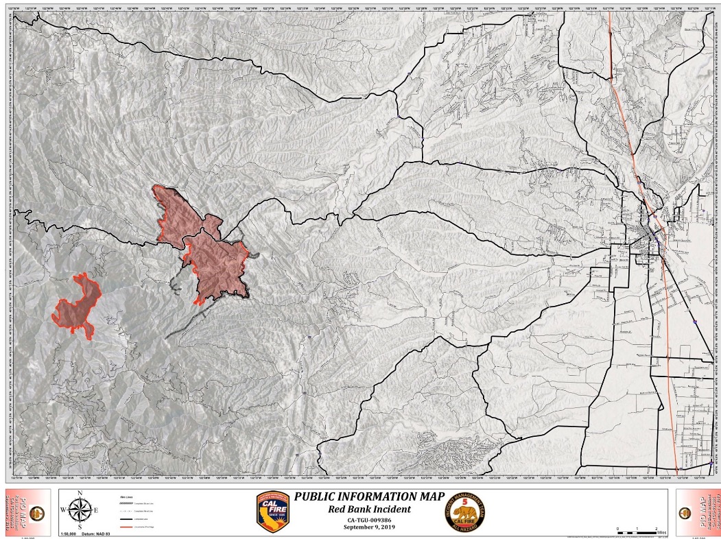
This fire is 4,419 acres and 50 percent contained, according to Ca.gov. It’s west of Red Bluff, off Hammer Loop Road and Petty John Road. Favorable fire conditions will continue through Tuesday. The South Fire is just west of this fire.
All mandatory evacuations and warnings were lifted, Ca.gov noted.
The following is a map of the Red Bank and the South Fire, providing by MappingSupport.com. They note: “#RedBankFire and #SouthFire west of Red Bluff, CA. Satellite hotspot data is always 3-9 hours old when you see it on a map. To learn more, click ‘Map Tips’ upper left corner.” *
It’s one of several fires in a close region. The fire is 25 miles west of Red Bluff, Red Bluff Daily reported.
Although Tehama County Deputy Sheriff’s Association’s Facebook page has been providing updates at first, they are now directing people to CalFire’s website here. Cal Fire Tehama-Glenn Unit is also sharing some updates on Facebook here.
You can also stay updated via Tehama’s Alert App.
SHF Lightning Fires 2019
Here are the latest updates on lightning fires in the region of 41.063 latitude, -122.638 longitude, according to Inciweb. The list below is a direct quote from Inciweb’s page on September 9.
South Fork Management Unit (Hayfork and Platina area)
09/05/2019 7:11, LITTLE, Yolla Bolla Wilderness, 0.25 acre, Out
09/05/2019 7:14, FORK, southwest of Platina west of Tedoc, 0.25 acre, Out
09/05/2019 8:57, LOVE, north of Hayfork near Love Letter Springs, 0.3 acre, Out
09/05/2019 9:34, NATURAL, near Natural Bridge > CAL FIRE SHU direct protection area
09/05/2019 1:50, SOUTH, SE of Tomhead MTN, 2050 acres (link goes to South Fire InciWeb page)
Trinity River Management Unit (Weaverville, Big Bar, Trinity Lake, Trinity Alps)
09/05/2019 7:09, EAST, Halls Gulch NE of Trinity Lake, 0.25 acres, CONTAINED
09/05/2019 7:22, LADY, Lady Gulch Trinity Alps Wilderness, 1 acre, CONTAINED
09/05/2019 7:25, LICK, east of Trinity Lake, unable to locate
09/05/2019 8:16, CEMENT, east of Trinity Lake, unable to locate
09/05/2019 8:18, FOOL, west of Trinity Lake, 0.1 acres, CONTAINED
09/05/2019 8:20, QUARTZ, west of Trinity Lake, unable To locate
09/05/2019 8:23, SLATE, west of Trinity Lake, 2 acres, CONTAINED
09/05/2019 9:07, MIDDLE, NE of Canyon Creek Trailhead, 223 acres, staffed
09/05/2019 10:13, EASTMAN, south of Tunnel Rock .25 acres, CONTAINED
09/05/2019 10:38, WAGNER, Billy’s Peak west of Trinity Lake, 0.1 acres, CONTAINED
09/05/2019 10:44, HATCHET, east of Poison Canyon .5 acres, CONTAINED
09/05/2019 11;15, JAKES, Jakes Upper Camp, 1.8 acres, staffed
09/05/2019 12:18, RANCH, located above Rancheria Creek, 0.2 acres, CONTAINED
09/05/2019 12:56, CUTTHROAT, west of Cutthroat Gulch, 15 acres, staffed
09/05/2019 2:29, IRISH, Jackass Springs, 0.1 acres, CONTAINED
09/05/2019 2:53, SWIFT, NW of Trinity Center, CONTAINED
09/05/2019 4:50, HOBEL, SW of Trinity Center, CONTAINED
09/05/2019 5:39, RAMSHORN, Ramshorn Creek north of Bonanza King Mtn., 279 acres, staffed
09/06/2019 10:14, HORSESHOE, Horseshoe Lake, 0.25 acres, CONTAINED
09/06/2019 12:34, LAKE, Toad Lake, 0.1 acres CONTAINED
Shasta Lake Ranger District and the National Recreation Area (Shasta Lake)
No fires detected
Shasta McCloud Management Unit (Mt Shasta and McCloud area)
09/05/2019 5:21, HERE, east of Hwy 3 and west of Castle Crags, 5.4 acres, CONTAINED
South Fire
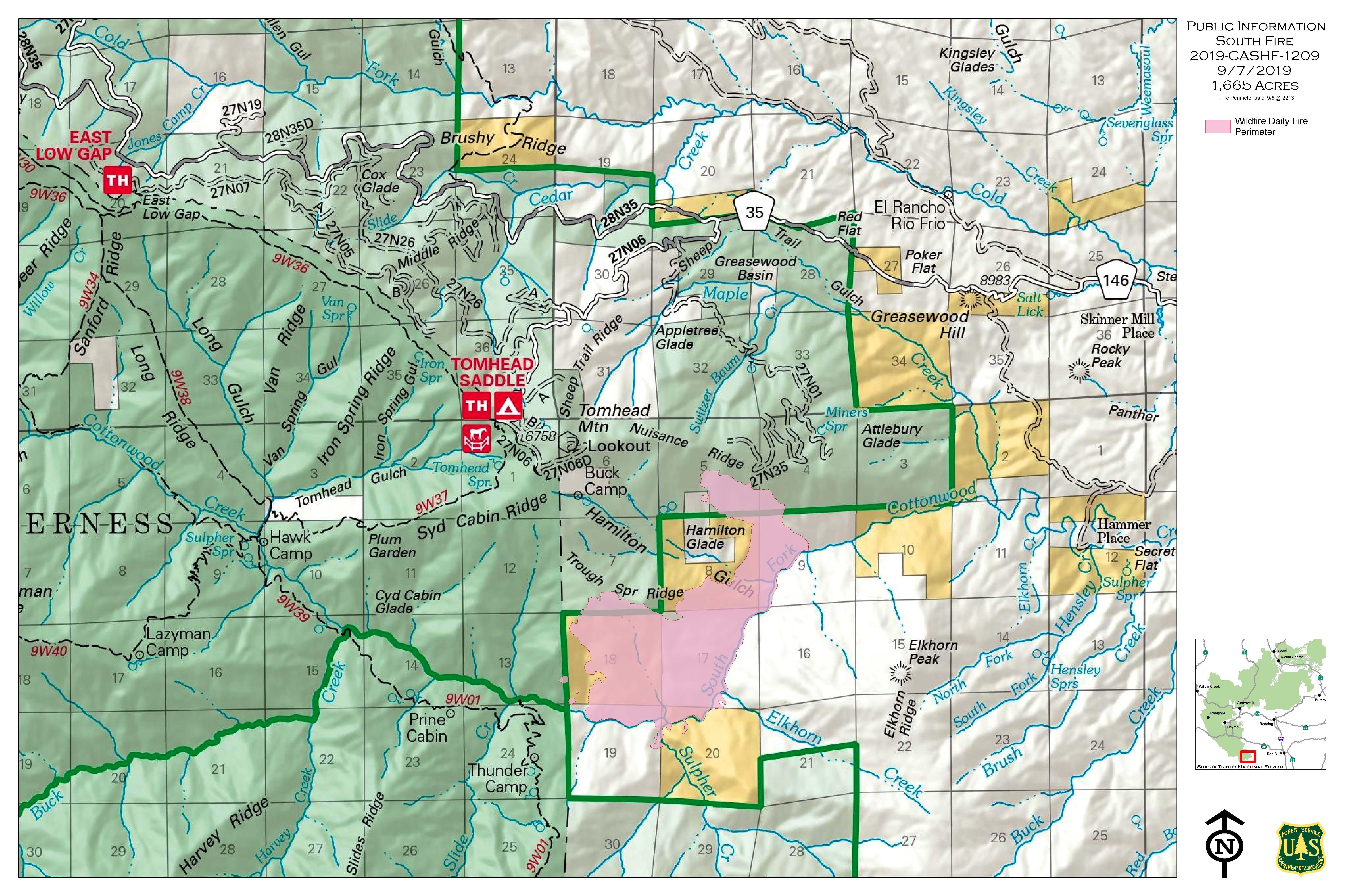
The South Fire started in Shasta-Trinity National Forest in Tehama County. As of September 9, the fire is now 2,425 acres in size according to Inciweb.
The fire is 15 miles south of Platina, California.
The following is a map of the Red Bank and the South Fire, providing by MappingSupport.com. They note: “#RedBankFire and #SouthFire west of Red Bluff, CA. Satellite hotspot data is always 3-9 hours old when you see it on a map. To learn more, click ‘Map Tips’ upper left corner.”
According to Inciweb, in the next 24 hours the fire is going to continue to spread up-canyon during the day and down-canyon at night. There’s a potential that the fire will move toward structures in the Black Camp and Tomhead Lookout areas.
Springs Fire
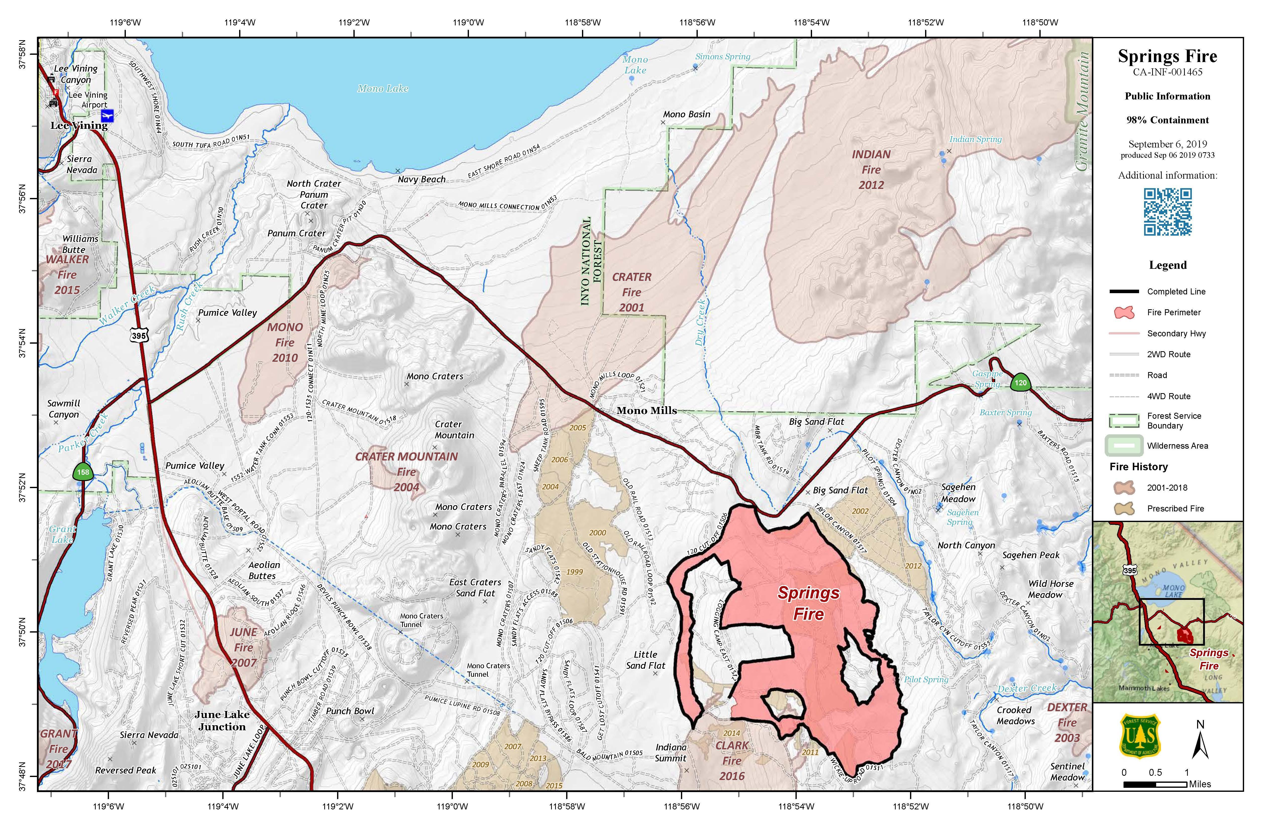
Inciweb
This fire is now 4,840 acres and 98 percent contained according to Ca.gov on September 6 and Inciweb on September 8. It was caused by lightning. It’s located 13 miles southeast of Lee Vining.
Inciweb gave a final update about the fire on September 8.
Due to hard work and dedication of the interagency firefighters and the percentage of containment, crews have been released from the Springs Fire. Firefighters will remain on the Springs Fire to continue patrolling the area, while suppression and repair crews make progress within the burned perimeter of the fire.
Strategic tactical firing operations were implemented in containment efforts on this fire creating low intensity fire effects. This should reduce the risk of a larger, longer-lasting, more severe wildfire in the future. Having recent fire history in place will make it safer for firefighters, when unwanted wildfires occur on the landscape.
Road and trail closures will remain in effect for the Springs Fire. Please observe all signage for your safety as post-wildfire areas are still dangerous. For further area, trail, and road closures information please visit our Inciweb site, https://inciweb.nwcg.gov/incident/6477/ or Facebook site, www.facebook.com/inyonf.”
Swedes Fire
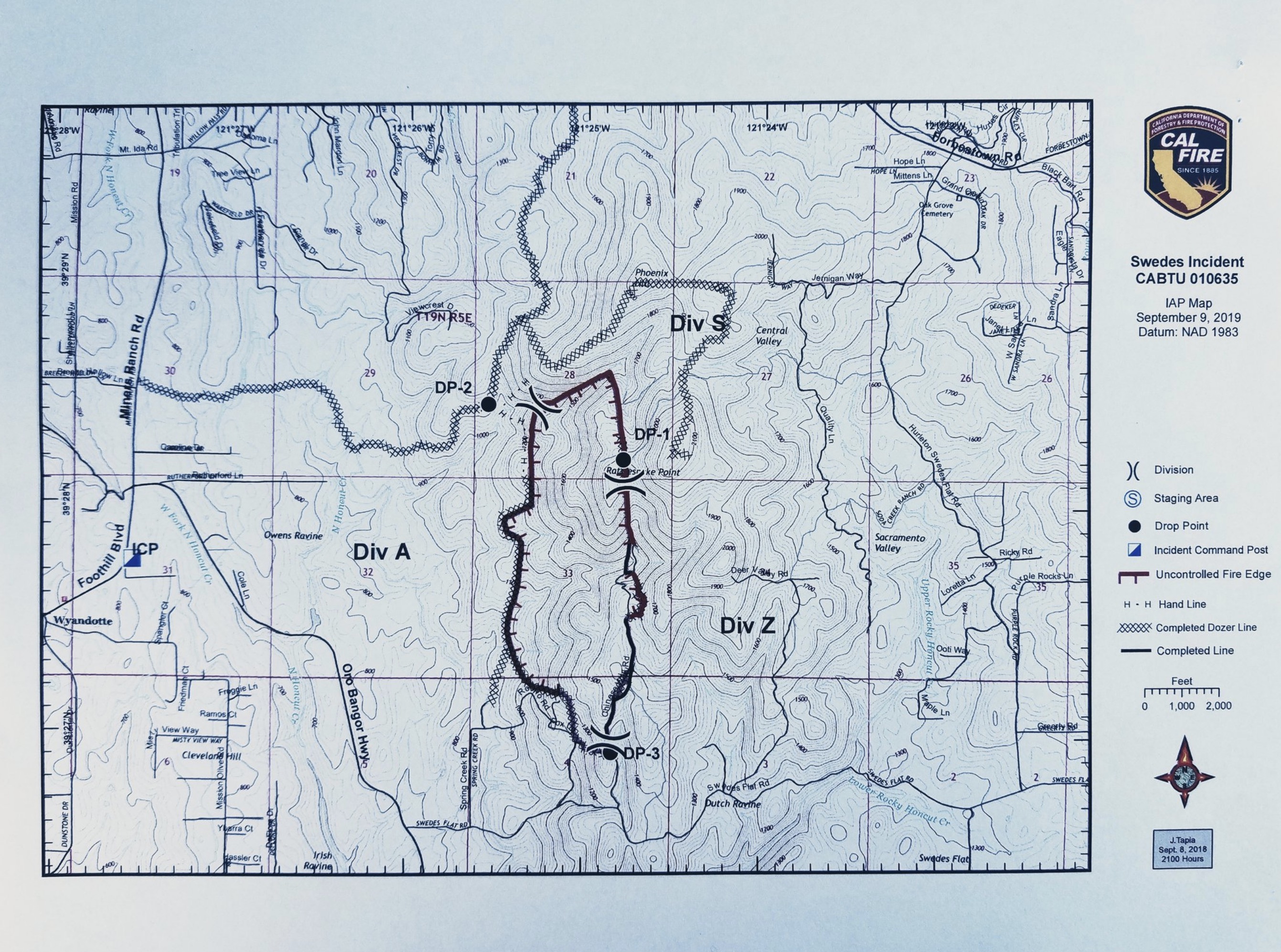
The Swedes Fire is near Swedes Flat Road and Oro Bangor Highway in Butte County, east of Oroville. It’s 400 acres in size and 40 percent contained as of September 9 at 11 a.m., Ca.gov noted.
Two structures were destroyed by the fire.
All evacuation warnings and orders have been lifted.
All road closures have also been lifted.
Stay updated on emergency alerts and more by signing up here. You can also follow the Butte County Sheriff’s Twitter page for details. Evacuation details can change quickly, so stay tuned to these sources for the latest updates.
#NVADG has officially been deactivated for the #SwedesFire.
Sheltered:
11 goats, 10 horses, 1 chicken and 2 dogs.
Animal rescue crews responded to 15 calls and assisted 35 animals to shelter in place.
To support our efforts please visit: t.co/ksGMZRjZgG

You can also stay updated by calling 530-538-7826 (the information line for the fire.)
Sycamore Fire
This fire was discovered on September 7. As of September 9, it’s 250 acres and 100 percent contained, according to Ca.gov. It was located in Riverside County.
Taboose Fire
This fire was 354 acres as of September 7, according to Inciweb, but now it’s 10,500 acres and 10 percent contained as of September 9. It’s southwest of Big Pine and northwest of Aberdeen. The cause is under investigation.
Here’s a map of the fire provided by MappingSupport.com. “For fire weather forecast, click map, follow link. Search the page that appears on CAZ226. Monday 30mph wind gusts from south and southwest.”
There’s a red flag warning today or high winds, which might cause problems for fire suppression. A community meeting was planned for 12:30 p.m. at the Big Pine Town Hall on September 9. Yesterday, stranded hikers were evacuated at Red Lake due to the fire.
Tenaja Fire
The Tenaja Fire is listed on Ca.gov’s map. It’s 1,926 acres in size and 90 percent contained as of September 9, according to CA.gov and Cal Fire.
The fire started near Tenaja Road and Clinton Keith Road in La Cresta on the afternoon of September 4. It started at 4:43 p.m. on September 4, according to the California Department of Forestry & Fire Protection, and then quickly grew in just a few hours.
Here’s a map of evacuation orders that was being updated by the County of Riverside. Yellow indicates voluntary evacuations and red indicates mandatory evacuations. Right now nothing is shaded because at this time, all evacuation warnings were lifted as of the evening of September 6, per RVCFire.org. Use the + icon to zoom into the map, which may be necessary depending on the browser you’re using.
You can visit the full-sized map here.
You can stay updated on the fire through the incident information page here.
Walker Fire in Susanville
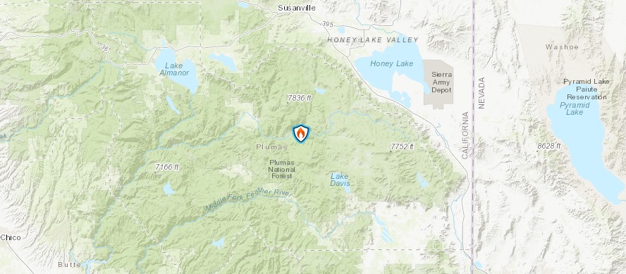
Inciweb
This fire was first reported on September 4 and the cause isn’t known. On September 9, according to Inciweb, the fire is now 49,931 acres and 7 percent contained.
Here’s a map from September 9.

It’s located east of Genesee near Indian Creek and Beckworth Genesee Road.
Here’s an interactive map of the Walker Fire by MappingSupport.com. They note: “Monday 9/9 #WalkerFire CA 43,931 acres per 10:57pm infrared flight yesterday + analysis by fire staff. To help you get the most benefit from using the map there is a “Legend” link and “Map tips” link in the upper left corner.”
According to Inciweb, the fire is burning on the Plumas National Forest about 11 miles east of Taylorsville.
Here are mandatory evacuation details, as shared by Inciweb unless otherwise indicatated:
- Residents residing along Hwy 395 from the Thunder Mountain Road (Wales Canyon) to the Laufman Grade (Old Hwy 59), including the communities of Milford and Brockman Canyon.
- Antelope Lake to the Plumas county line, the Genesee Valley road corridor, the Ward Creek area, and the Flournoy Bridge area also remain under mandatory evacuation orders.
An evacuation center is set up at Lassen County Fairgrounds at 195 Russell AVe in Susanville.
Here are road closure details from Inciweb:
- Janesville Grade
- Genesee Valley road at the Flournoy Bridge
- Antelope Lake road from the Flournoy Bridge to Antelope Dam
- Beginning at the Flournoy Bridge turnoff, the 111 Beckwourth-Genesee road is closed through the fire area.
- Hwy 395 will remain open to through traffic.
U.S. Forest Service noted:
The fire activity decreased last night over the fire area. Containment line that is in place held. On the east side of the fire, dozer line was constructed around the northeastern leading edge of the fire near Round Mountain and Stoney Creek. Hose lays will be installed to reinforce the containment lines. Dozers continued progress constructing dozer line advancing north from Ingalls Peak. Crews constructed line directly along the southeast-east edge of the fire which held as well. Firefighters constructed fireline around the structures on the southwest edge of the fire to further protect the structures. The fire is staying in place at the 25N42 road.
Structure preparation is complete around structures to the west of Wheeler Peak drainage. Dozers and handcrews made good progress building fireline along the west side of the fire progressing north. Crews working around the fire will continue constructing containment line and holding what’s in place.”
Here’s an infrared map of the fire:
If you’re in Plumas County, you can sign up for emergency notices here. Or call 530-616-8625 for updates.
READ NEXT: WATCH: Man with TV on Head Leaves CRT TVs on Porches in Virginia