NHC screenshot
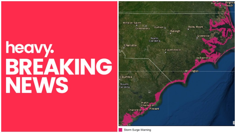
With sustained winds of 110 mph and heavy rain bands, Hurricane Dorian is causing storm surge and flooding in the Carolinas with surge and flood warnings posted along the coast of the Carolinas from just north of Savannah, Georgia to Virginia Beach, Virginia, according to the National Hurricane Center.
A storm surge warning means there is a danger of life-threatening inundation, from rising water moving inland from the coastline, during the next 36 hours. People in these areas should take all necessary actions to protect life and property from rising water and the potential for other dangerous conditions, the NHC cautions.
The combination of a dangerous storm surge and the tide will cause normally dry areas near the coast to be flooded by
rising waters moving inland from the shoreline. Predictions include Isle of Palms to Myrtle Beach with up to an 8-foot surge, the Savannah River to Isle of Palms up to 7 feet, Myrtle Beach to Cape Lookout up to 7 feet, Cape Lookout to Duck, North Carolina including Pamlico and Albemarle Sounds and the Neuse and Pamlico Rivers up to 6 feet, and Duck to Poquoson, Virginia including Hampton Roads up to 4 feet.
Expected rainfall is six to 12 inches in the Carolinas, and possibly more. This rainfall may cause life-threatening flash floods.
As Dorian made landfall Friday morning at Cape Hatteras, there are new warnings about flash floods and storm surge.
Live feed in Elizabeth City, NC with view of flooding intersection. Heavy rainfall and high winds here. Power is out. #HurricaneDorian #DorianNC #ncwx #nc #pasquotank #elizabethcity t.co/jnghU8IyRz
NC 12 on the Outer Banks is seeing serious sound side flash flooding.
Power lines down in spots across Charleston, SC. This one has a tree on fire. @weatherchannel @CityCharleston @JimCantore @StephanieAbrams @Paul_Goodloe
Hurricane Dorian has arried in Charleston. Flooding underway. #flood #dorian #hurricanedorian @MyRadarWX
“Stay where you are”: Police in Isle of Palms, near Charleston, South Carolina, warn people to stay indoors as Hurricane Dorian takes aim at the Carolinas. t.co/dBTdiUV87c
And when storm surge and flooding were not enough, Dorian apparently has spurned tornadoes.
Out checking on some properties we manage and this happened. @EdPiotrowski @wpdeabc15 @WBTWNews13 @TheWeatherCH @wmbfnews