NOAA Gabrielle and Fernand projected paths and trackers
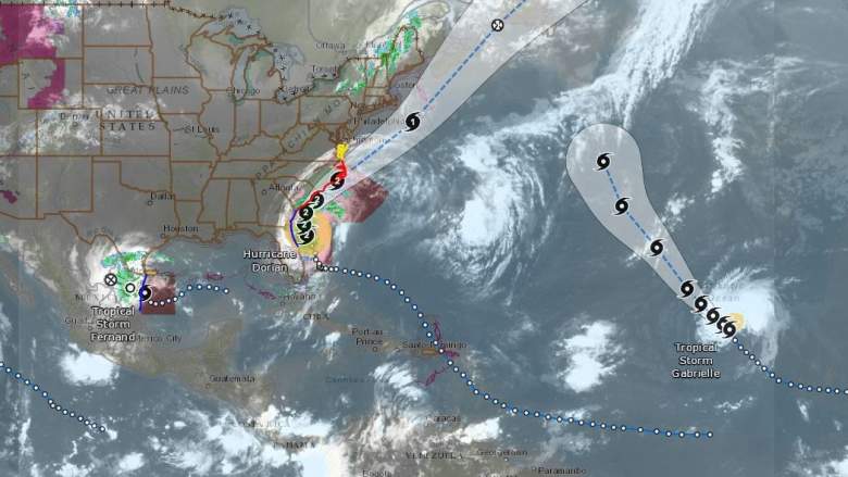
While Hurricane Dorian continues to move along the coast of the United States, two additional storms are now gaining attention. Tropical Storm Fernand is moving onto Mexico, and Tropical Storm Gabrielle has just recently formed. Below are trackers and projected paths for both storms. If you want to see trackers for Dorian, please see Heavy’s story here.
Live Gabrielle & Fernand Interactive Map Trackers
A live map showing Gabrielle’s and Fernand’s current locations and projected paths is provided by the NOAA’s nowCoast website below. You can see the full version here. Hit the plus button in the map below to zoom in to see the details about the storm’s track. This is a live tracker because it is updated automatically as the storms move.
Google has two tropical storm trackers, here and here, for tracking tropical storms. A map showing Gabrielle’s and Fernand’s tracks is embedded below, provided by Google. It also shows other storms like Dorian. You may need to use the + button to zoom into the relevant portion of the map, depending on your browser. This is a live tracker because it is updated automatically as the storms move.
Gabrielle’s Projected Path & Maps for September 4

NOAA
Above is a map above from the National Hurricane Center showing a forecast cone for Gabrielle, updated for September 4. This map does not indicate the storm’s size, but it does show its current projected path.
At this point, because the storm is far out in the ocean, there are no relevant wind speed or rainfall probabilities for the U.S. coast.
Here’s another map from the NOAA. You can see the interactive version of this map here.
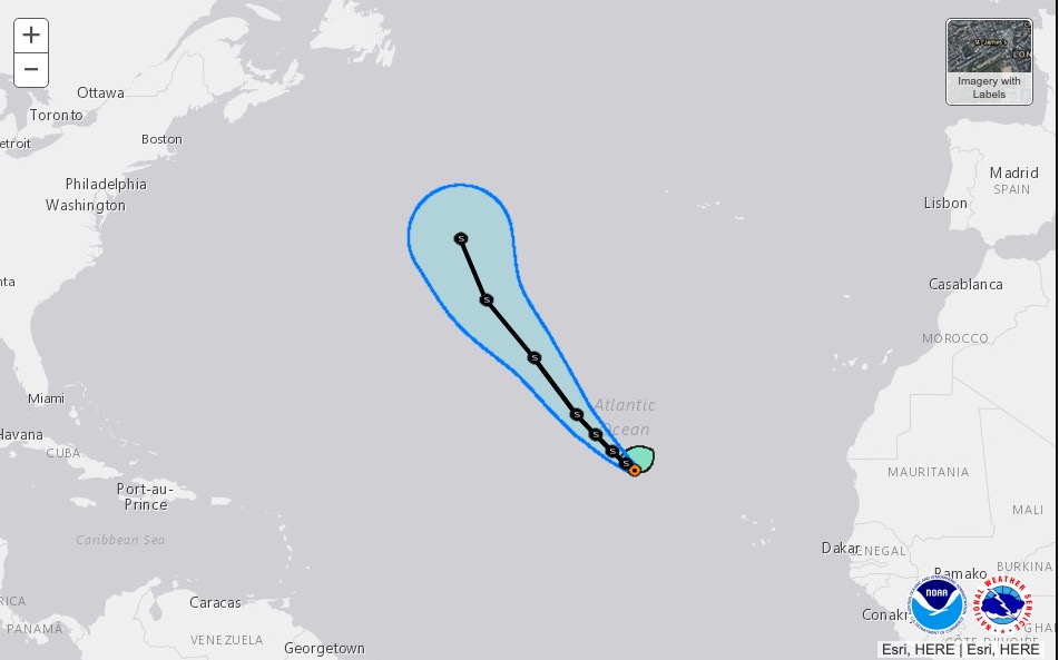
According to the NOAA at 11 a.m. on September 4, Gabrielle was at 20.5 N and 33.8 W. The storm is 715 miles west-northwest of the Cabo Verde Islands and about 1,275 miles south-southwest of the Azores. Maximum sustained winds are only 50 mph at this time. It’s moving northwest or 320 degrees at 9 mph. The minimum central pressure is 1003 mb or 29.62 inches.
The NOAA said at 11 a.m.: “Gabrielle is moving toward the northwest near 9 mph (15 km/h), and this motion is expected to continue through Saturday, with an increase in forward speed expected late in the week. Maximum sustained winds have increased to near 50 mph (85 km/h) with higher gusts. Little change in strength is forecast during the next
few days.”
In more detailed discussions, NOAA added:
“Gabrielle appears better organized on satellite imagery this morning with the low-level center moving a little more underneath the convection. In addition, a large curved band has become better defined in the northern semicircle. The initial wind speed is increased to 45 kt, which is consistent with a just-received ASCAT-C pass of 40-45 kt.
“The initial motion estimate is 320/8. For the next 5 days, Gabrielle is forecast to move generally northwestward toward a break in the Bermuda-Azores high pressure ridge located between 40W-50W longitude. An increase in forward speed in a few days is expected due to the gradient between an upper-level low to the west and the ridge to the northeast. The official forecast track lies slightly to the east of the previous forecast in the short term, and then is very close to the previous NHC track in days 3 to 5.
“Gabrielle is expected to remain in a marginal environment during the next 2 to 3 days, with moderate southerly to southwesterly wind shear, low values of mid-level relative humidity and SSTs near 26-27C. No change in wind speed is predicted during the first two
days. Thereafter, some strengthening is possible as Gabrielle moves on the northeast side of the upper-level low concurrent with the cyclone moving over warmer water. This is a typical situation for intensification, so the forecast wind speed is raised slightly at
days 4-5. The intensity forecast is fairly consistent with the bulk of the typically reliable intensity models.”
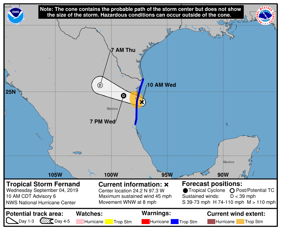
Fernand’s Projected Path & Maps for September 4
NOAA
Above is a map above from the National Hurricane Center showing a forecast cone for Fernand, updated for September 4. This map does not indicate the storm’s size, but it does show its current projected path. Fernand’s main threat is to Mexico.
Next is the estimated arrival times for Fernand’s winds.

NOAA
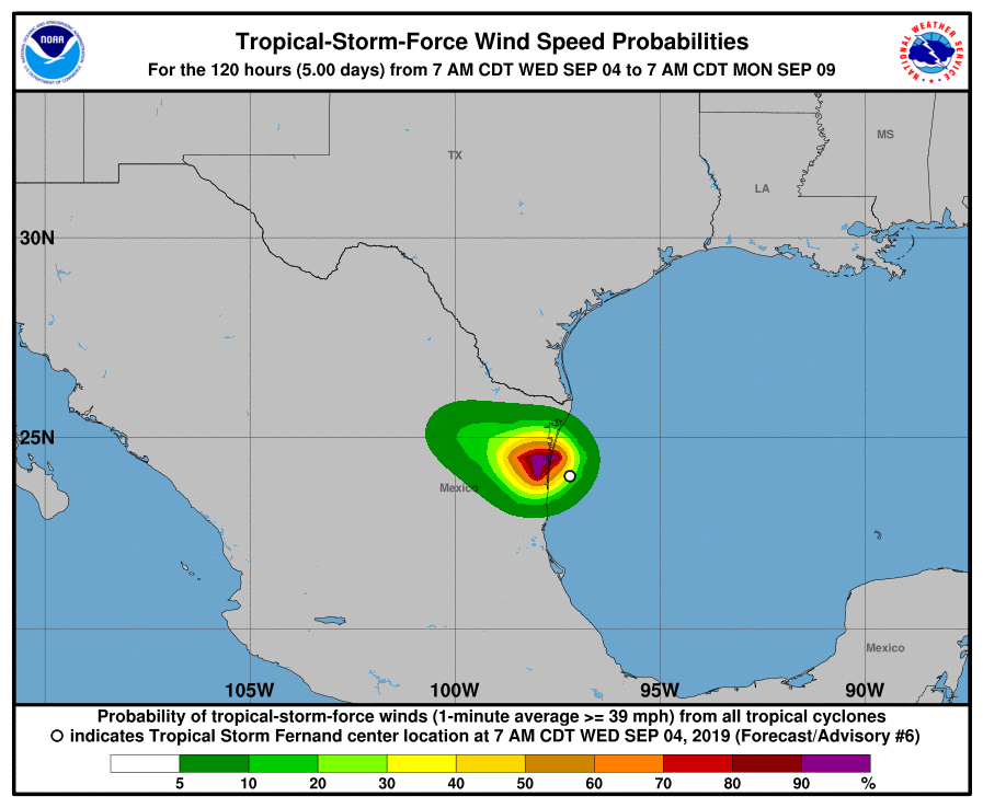
And the wind speed probability for Fernand is below.
NOAA
Next is the rainfall probability for Fernand.

NOAA
Here’s an update on Fernand from NOAA as of 10 a.m. on September 4.
“At 1000 AM CDT (1500 UTC), the center of Tropical Storm Fernand was located near latitude 24.2 North, longitude 97.3 West. Fernand is moving toward the west-northwest near 8 mph (13 km/h). A motion toward the west or west-northwest is expected today, and the center of Fernand is forecast to cross the northeastern coast of Mexico this afternoon or evening, and move farther inland tonight.
Maximum sustained winds are near 45 mph (75 km/h) with higher gusts. Little change in strength is expected before the center moves onshore. Once inland, rapid weakening is expected, and Fernand should dissipate on Thursday. Tropical-storm-force winds extend outward up to 80 miles (130 km) from the center. The estimated minimum central pressure is 1002 mb (29.59 inches).”
READ NEXT: Hurricane Dorian Maps: Projected Path & Live Trackers