NOAA
Hurricane Dorian is still a dangerous hurricane as it moves parallel to the coast, with the eyewall just offshore of South Carolina. The storm left parts of the Bahamas in devastation, but an early track the predicted landfall at Florida did not end up happening. Read on to see maps and trackers of Hurricane Dorian’s path, updated for September 5, how close it may come to different states on the coast, along with the storm’s projected path. Hurricanes are unpredictable, so stay tuned as details can change over time.
Live Hurricane Dorian Interactive Map Trackers
A live map is provided by the NOAA’s nowCoast website below. You can see the full version here. Hit the plus button in the map below to zoom in to see the details about the hurricane’s track.
Google has two hurricane trackers, here and here, for tracking the storm. The only one that’s embeddable is shown below. Depending on your browser, you may need to zoom into the map below using the + button to see the hurricane’s track. (Some browsers will show a far-away view despite the settings, but zooming in will allow you to see the map in full.)
MappingSupport.com offers an interactive Dorian map below. In a tweet about the map, users are advised: “Click dot then follow link for actual rain and wind data. Overlay layers can be turned on/off/restacked. Click ‘Map tips’ upper left corner to learn how. Data hosted on federal #GIS servers.” You can view the full map here.
Here’s a live tracker from Fox News. Dorian is currently a Category 2. Current projections don’t have Dorian actually making landfall, but skimming the coast and then going out to sea.
And next is a track from WTSP.
And here’s a live tracker from Windy.com.
Live Streams from the Carolinas
The Cape Fear Frying Pan Flag Cam is online. It’s 34 miles off the coast of North Carolina in the Atlantic Ocean.
Surfline is providing live webcams from Florida to the Carolinas, switching periodically from different views.
The YouTube channel Mr. Everywhere is providing streams of cameras on the east coast.
Next is a cam from Myrtle Beach, South Carolina. This one is provided by Cramer Snuggs.
Here’s a live vehicle cam in North Carolina from hurricanetrack.
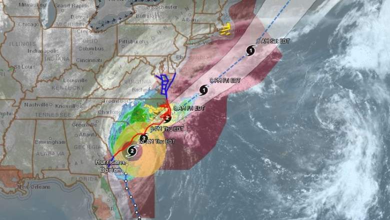
Hurricane Dorian’s Projected Path on September 5

Above is a map above from the National Hurricane Center showing a forecast cone and coastal watches and warnings released today, updated for September 5. This map does not indicate the hurricane’s size, but it does show the hurricane’s current projected path.
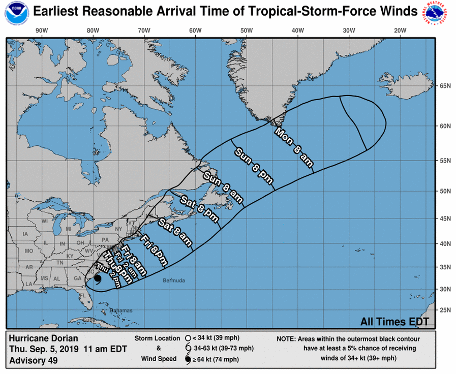
This next map may give you a better idea of when to first expect to feel the effects of the hurricane. This map shows the estimated arrival time of tropical storm force winds. The map below was updated Sept. 5.
NOAA
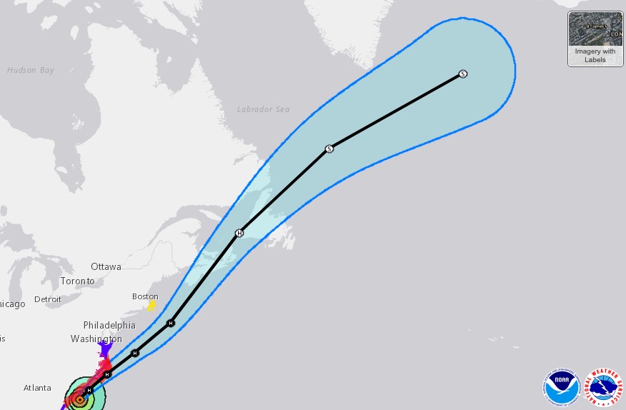
Next is a different look at the hurricane’s projected path. Keep in mind that this map has an interactive component that you can view here. This screenshot is from September 5.
Wind Projection Maps of Hurricane Dorian
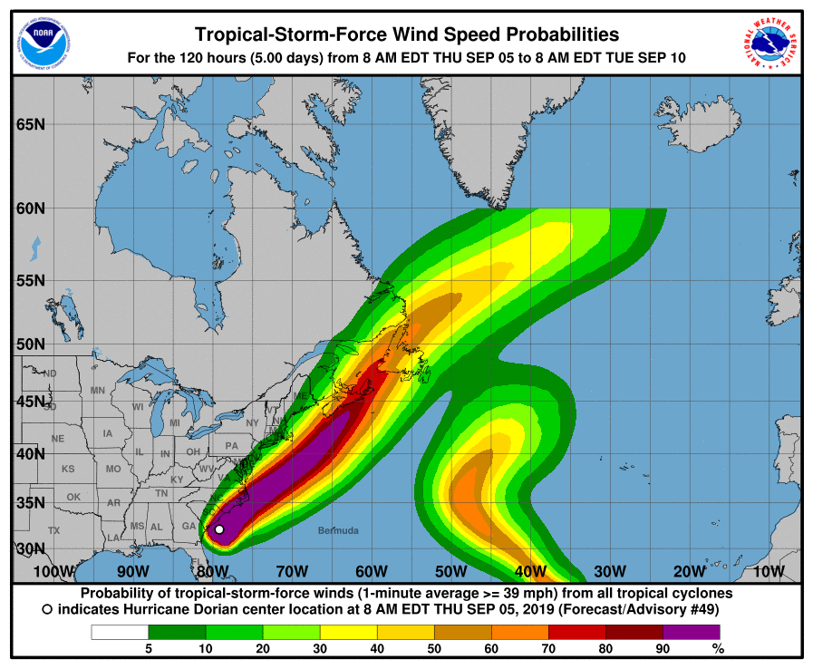
Next up is a wind-speed probability map. This shows the probability of tropical storm force winds, as predicted on September 5.
And next are predictions for the probability of hurricane force winds.
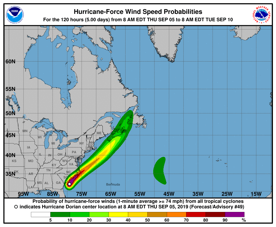
NOAA
Rainfall & Flooding Potential Maps
This next map from NOAA shows the rainfall potential.
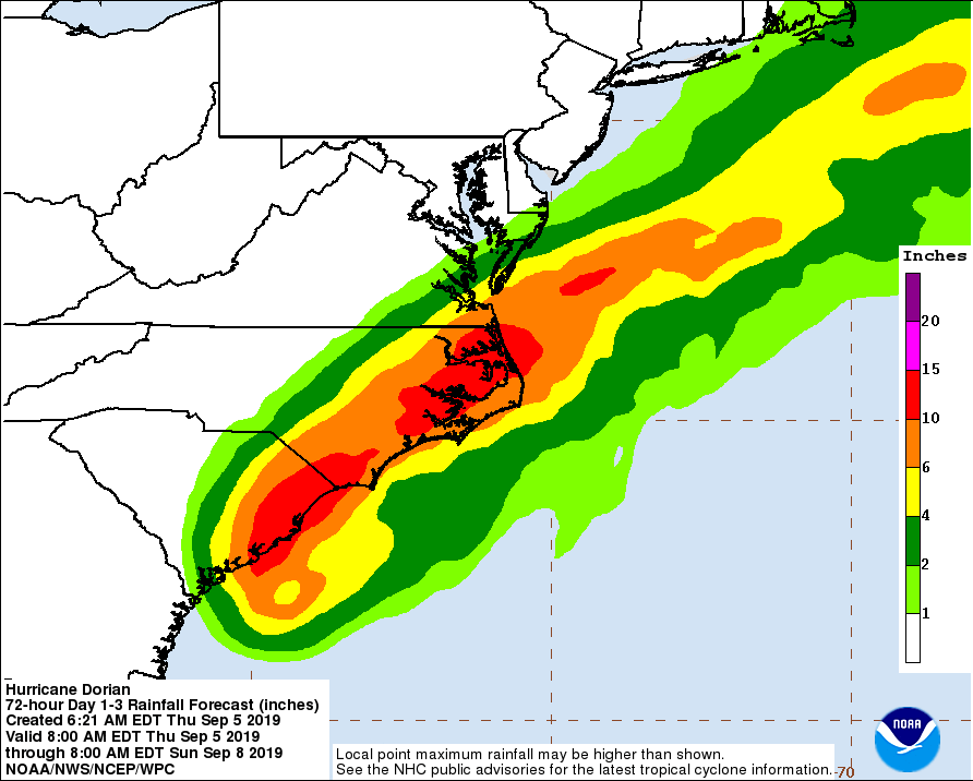
NOAA
According to the National Hurricane Center on September 5 at 1 p.m., Hurricane Dorian is currently at 32.7 N, 79.0 W. It’s about 55 miles east of Charleston, South Carolina and 125 miles south-southwest of Wilmington, North Carolina.
The storm is moving north-northeast or 20 degrees at 8 mph.
Maximum winds are currently 110 mph, up from 105 mph last night. Minimum central pressure is 958 mb (28.29 inches).
At 11 a.m., NOAA released the following information.
“Dorian is moving toward the north-northeast near 8 mph (13 km/h). A turn toward the northeast is anticipated by tonight, and a northeastward motion at a faster forward speed is forecast on Friday. On the forecast track, the center of Dorian will continue to move close to the coast of South Carolina today, and then move near or over the coast of North Carolina tonight and Friday. The center should move to the southeast of extreme southeastern New England Friday night and Saturday morning, and approach Nova Scotia later on Saturday.
“Reports from Air Force Reserve and NOAA Hurricane Hunter aircraft indicate that maximum sustained winds are now near 110 mph (175 km/h) with higher gusts. Slow weakening is expected during the next few days. However, Dorian is expected to remain a powerful hurricane as the center moves near the coasts of South and North Carolina. Hurricane-force winds extend outward up to 60 miles (95 km) from the center and tropical-storm-force winds extend outward up to 195 miles (315 km). The Weatherflow station at Winyah Bay, South Carolina, recently reported sustained winds of 60 mph (97 km/h) and a wind gust of 76 mph (122 km/h). Charleston International Airport recently reported sustained winds of 40 mph (64 km/h) and a wind gust of 56 mph (91 km/h).”
A 1 p.m. Eastern update added: “Multiple observing stations located in and around Charleston Harbor have reported wind gusts of 75-80 mph (120-129 km/h) within the last hour. A Weatherflow site in Winyah Bay, SC recently reported a wind gust of 86 mph (138 km/h) at a height of 50 ft.”
READ NEXT: Dorian Live Radar, Satellite Streams & Florida Web Cams