NWS A video showed a family trapped in their attic by Hurricane Dorian.
A video has circulated showing the dangers posed by Hurricane Dorian; a family is trapped in an attic in the Bahamas by rising waters, according to news reports circulating the video. The video circulated out of Freeport, and the fate of the family was not known. You can watch the video later in this article.
Although Dorian was pounding the Bahamas, there was increasing hope for the coast of Florida.
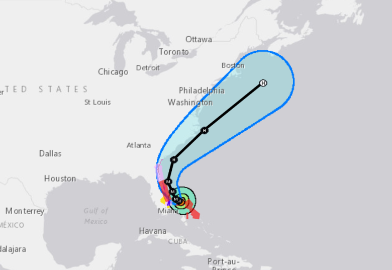
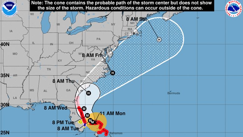
“At 200 PM EDT (1800 UTC), the eye of Hurricane Dorian was located near latitude 26.8 North, longitude 78.4 West. Dorian is moving very slowly toward the west-northwest near 1 mph (2 km/h),” the National Hurricane Center reported on Labor Day.
“A slow westward to west-northwestward motion is forecast during the next day or so, followed by a gradual turn toward the northwest and north. On this track, the core of extremely dangerous Hurricane Dorian will continue to pound Grand Bahama Island through much of today and tonight. The hurricane will then move dangerously close to the Florida east coast late tonight through Wednesday evening and then move dangerously close to the Georgia and South Carolina coasts on Wednesday night and Thursday.” You can follow the National Hurricane Center’s Dorian page here.
Here’s the attic video:
Here’s what you need to know:
There Were Catastrophic Winds Over Grand Bahama Island
National Hurricane Center
As of 2 p.m. EDT, the National Weather Service was reporting that “…LIFE-THREATENING STORM SURGE AND CATASTROPHIC WINDS CONTINUE OVER GRAND BAHAMA ISLAND…” The NWS gave this location and wind speed for the hurricane:
SUMMARY OF 200 PM EDT…1800 UTC…INFORMATION
———————————————-
LOCATION…26.8N 78.4W
ABOUT 25 MI…40 KM NE OF FREEPORT GRAND BAHAMA ISLAND
ABOUT 105 MI…170 KM E OF WEST PALM BEACH FLORIDA
MAXIMUM SUSTAINED WINDS…150 MPH…240 KM/H
PRESENT MOVEMENT…WNW OR 285 DEGREES AT 1 MPH…2 KM/H
MINIMUM CENTRAL PRESSURE…938 MB…27.70 INCHES
These watches and warnings were in effect, per NWS:
“A Storm Surge Warning is in effect for…
* Lantana to the Flagler/Volusia County Line
A Storm Surge Watch is in effect for…
* North of Deerfield Beach to south of Lantana
* Flagler/Volusia County Line to the Savannah River
A Hurricane Warning is in effect for…
* Grand Bahama and the Abacos Islands in the northwestern Bahamas
* Jupiter Inlet to the Flagler/Volusia County Line
A Hurricane Watch is in effect for…
* North of Deerfield Beach to Jupiter Inlet
* Flagler/Volusia County Line to the Altamaha Sound Georgia
A Tropical Storm Warning is in effect for…
* North of Deerfield Beach to Jupiter Inlet
A Tropical Storm Watch is in effect for…
* North of Golden Beach to Deerfield Beach
* Lake Okeechobee.”
The NWS gave the following 2 p.m. update for Sept. 2, 2019:
“Maximum sustained winds are near 150 mph (240 km/h) with higher gusts. Dorian is an extremely dangerous category 4 hurricane on the Saffir-Simpson Hurricane Wind Scale. Although gradual weakening is forecast, Dorian is expected to remain a powerful hurricane during the next couple of days.
Hurricane-force winds extend outward up to 45 miles (75 km) from the center and tropical-storm-force winds extend outward up to 140 miles (220 km). Sustained winds of 56 mph (91 km/h) with a gust to 69 mph (111 km/h) was recently reported at a NOAA Coastal Marine observing site at Settlement Point on the west end of Grand Bahama Island. A wind gust to 48 mph (78 km/h) was recently report at Juno Beach Pier, Florida. The latest minimum central pressure reported by an Air Force
Reserve Hurricane Hunter aircraft is 938 mb (27.70 inches).”
HAZARDS AFFECTING LAND
———————-
“WIND: Catastrophic hurricane conditions continue on Grand Bahama Island. Do not venture out into the eye, as winds will suddenly increase after the eye passes.
Hurricane conditions are expected within the Hurricane Warning area in Florida by late tonight or Tuesday. Hurricane conditions are possible in the Hurricane Watch area on Wednesday.
Tropical storm conditions are expected within the Tropical Storm warning area today and Tuesday, and are possible in the Tropical Storm watch area by tonight.
STORM SURGE: A life-threatening storm surge will raise water levels by as much as 18 to 23 feet above normal tide levels in areas of onshore winds on Grand Bahama Island. Near the coast, the surge will be accompanied by large and destructive waves. Water levels should very slowly subside on the Abaco Islands during the day.
The combination of a dangerous storm surge and the tide will cause normally dry areas near the coast to be flooded by rising waters moving inland from the shoreline. The water could reach the following heights above ground somewhere in the indicated areas if the peak surge occurs at the time of high tide…
Lantana to the Savannah River…4 to 7 ft North of Deerfield Beach to Lantana…2 to 4 ft
Water levels could begin rise well in advance of the arrival of strong winds. The surge will be accompanied by large and destructive waves. Surge-related flooding depends on the how close the center of Dorian comes to the coast, and can vary greatly over short distances. For information specific to your area, please see products issued by your local National Weather Service forecast office.
RAINFALL: Dorian is expected to produce the following rainfall totals through late this week:
Northwestern Bahamas…12 to 24 inches, isolated 30 inches. Central Bahamas…Additional 1 to 3 inches, isolated storm totals of 6 inches. Coastal Carolinas…5 to 10 inches, isolated 15 inches. Atlantic Coast from the Florida peninsula through Georgia…4 to 8 inches, isolated 10 inches. This rainfall may cause life-threatening flash floods.
SURF: Large swells are affecting east-facing shores of the Bahamas and the Florida east coast, and will spread northward along the southeastern United States coast during the next few days. These swells are likely to cause life-threatening surf and rip current conditions. Please consult products from your local weather office.
TORNADOES: Isolated tornadoes are possible this afternoon into tonight along the immediate coast of east-central Florida.”