NWS
Fort Lauderdale is bracing for potential impact from Hurricane Dorian as the massive storm heads toward the United States.
Will Hurricane Dorian hit Fort Lauderdale, Florida? On Sept. 1, 2019, the National Weather Service reported that tropical storm conditions are possible for Fort Lauderdale starting on Monday evening with “hurricane conditions also possible.” Hurricane conditions were also reported as possible in that community on Tuesday. You can see the detailed weather forecast, including radar, for Fort Lauderdale here.
See the National Hurricane Center’s Dorian update page here.
The eye of #Dorian has made a second landfall at 2 pm EDT (1800 UTC) on Great Abaco Island near Marsh Harbour. Maximum sustained winds were 185 mph at the time. This is tied for the strongest Atlantic hurricane landfall on record with the 1935 Labor Day hurricane.
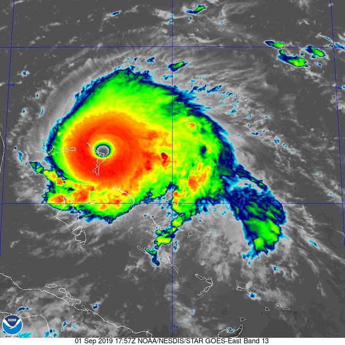
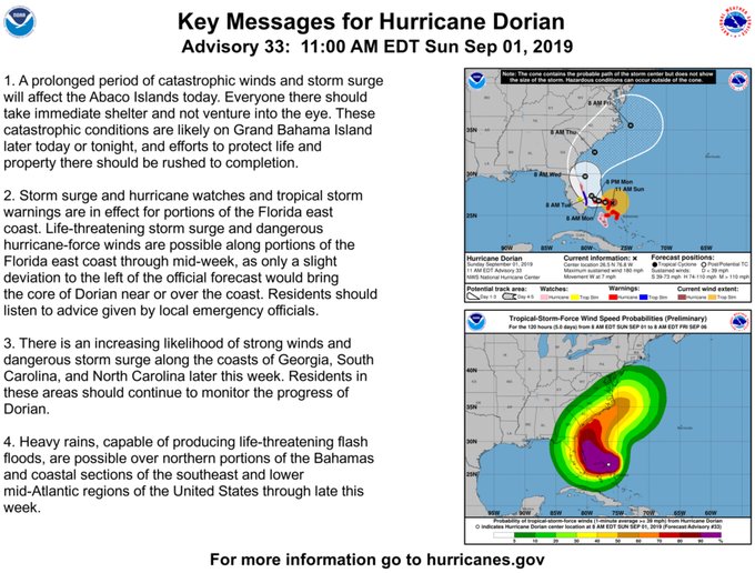
Here’s a roundup of the best sites to get updated spaghetti models for Dorian. At 3 p.m. on Sept. 1, the National Hurricane Center warned, “…EYE OF CATASTROPHIC HURRICANE DORIAN OVER THE ABACOS ISLANDS IN THE BAHAMAS… …HEADING WITH ALL ITS FURY TOWARD GRAND BAHAMA…” That update reported:
LOCATION…26.5N 77.1W
ABOUT 0 MI…0 KM OVER GREAT ABACO ISLAND
ABOUT 185 MI…295 KM E OF WEST PALM BEACH FLORIDA
MAXIMUM SUSTAINED WINDS…185 MPH…295 KM/H
PRESENT MOVEMENT…W OR 270 DEGREES AT 7 MPH…11 KM/H
MINIMUM CENTRAL PRESSURE…911 MB…26.90 INCHES
Latest #DorianFTL update posted at t.co/08Q2zX1zma. The @NWSNHC has issued a Tropical Storm Watch for Broward. Tropical storm conditions (sustained winds of 39-73 mph) are possible in Watch area w/in 48hrs. Please stay alert & prepared. @FLPD411 @FLFR411 @playlauderdale

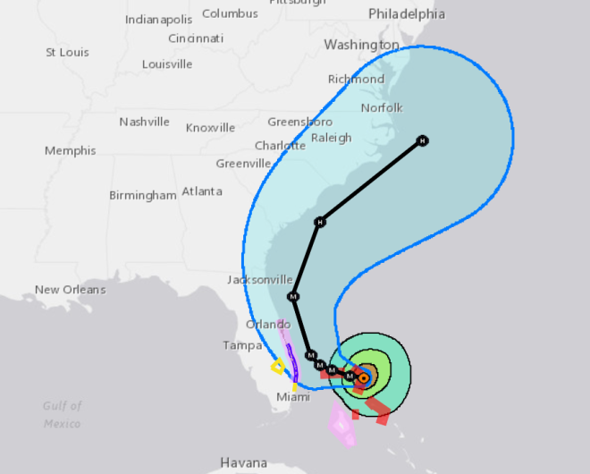
The forecast cone at 2 p.m. on Sept. 1:
It’s a Category 5 storm. It’s not clear whether it will skim the Florida coast or make landfall there, but recent models have given some hope it won’t make a direct strike on Florida. Officials are taking no chances, though.
Here’s what you need to know:
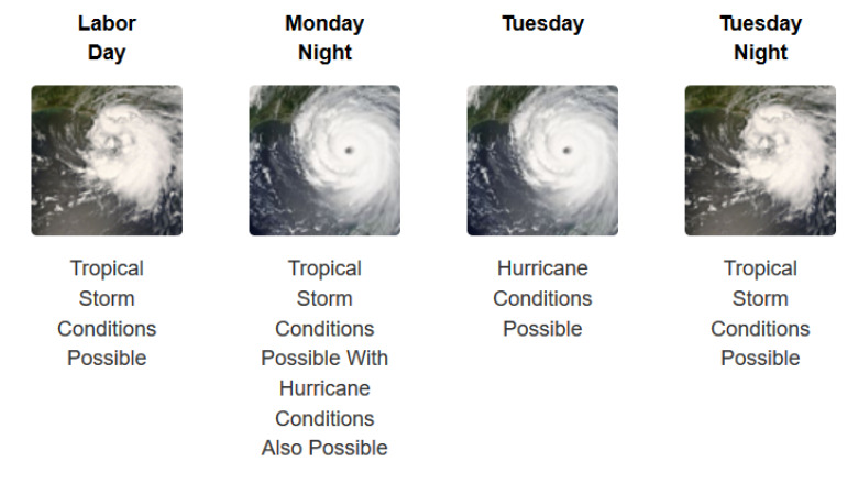
Fort Lauderdale Could See Tropical Storm Conditions as Early as Sunday Evening
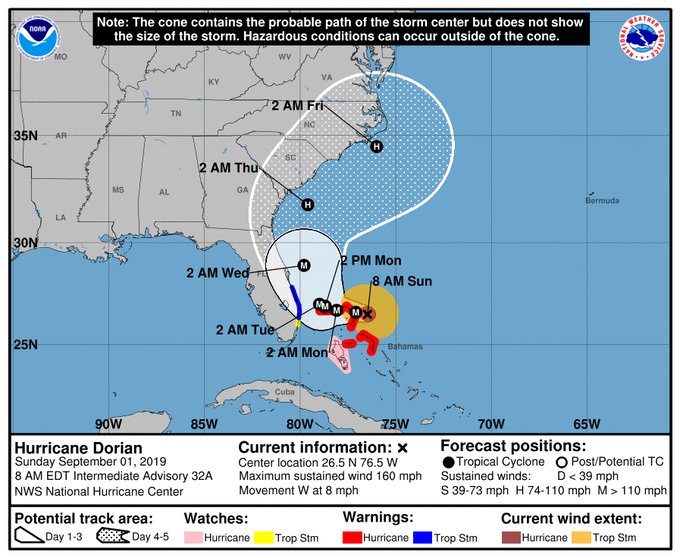
At 11 am Hurricane Dorian’s max winds were 180 mph. Doiran is moving west @ 7 mph. The eye is starting to move over Great Abaco Island, & is 205 mi east of West Palm Beach FL. Very small shifts in the forecast track could bring the core of Dorian onto the coast from FL to NC.


Here is the detailed weather forecast for Fort Lauderdale, Florida, as of Sept. 1.
“This Afternoon (Sept. 1)
A 50 percent chance of showers and thunderstorms. Partly sunny, with a high near 90. Heat index values as high as 103. North wind around 10 mph. New rainfall amounts between a tenth and quarter of an inch, except higher amounts possible in thunderstorms.
Tonight
Tropical storm conditions possible. Showers likely and possibly a thunderstorm before 9pm, then a chance of showers and thunderstorms between 9pm and 3am, then a chance of showers after 3am. Cloudy, with a low around 76. Chance of precipitation is 60%. New rainfall amounts between a tenth and quarter of an inch, except higher amounts possible in thunderstorms.
Labor Day
Tropical storm conditions possible. A chance of showers and thunderstorms, then showers likely and possibly a thunderstorm after 9am. Cloudy, with a high near 88. Chance of precipitation is 70%. New rainfall amounts between a quarter and half of an inch possible.
Monday Night
Tropical storm conditions possible, with hurricane conditions also possible. Showers likely and possibly a thunderstorm before 11pm, then a chance of showers and thunderstorms between 11pm and midnight, then a chance of showers after midnight. Cloudy, with a low around 76. Chance of precipitation is 70%.
Tuesday
Hurricane conditions possible. A chance of showers, then showers likely and possibly a thunderstorm after 9am. Cloudy, with a high near 86. Chance of precipitation is 60%.
Tuesday Night
Tropical storm conditions possible. Showers likely and possibly a thunderstorm before 9pm, then a chance of showers and thunderstorms between 9pm and midnight, then a chance of showers after midnight. Mostly cloudy, with a low around 78. Chance of precipitation is 60%.
Wednesday
A chance of showers, with thunderstorms also possible after noon. Mostly cloudy, with a high near 91. Breezy, with a southwest wind 13 to 16 mph, with gusts as high as 24 mph. Chance of precipitation is 40%.
Wednesday Night
A 40 percent chance of showers and thunderstorms, mainly before 9pm. Mostly cloudy, with a low around 78. Southwest wind 9 to 13 mph, with gusts as high as 20 mph.
Thursday
A 20 percent chance of showers and thunderstorms after 3pm. Partly sunny, with a high near 92. West wind 7 to 10 mph.
Thursday Night
A 20 percent chance of showers and thunderstorms before 9pm. Partly cloudy, with a low around 77.
Friday
Mostly sunny, with a high near 92.
Friday Night
Partly cloudy, with a low around 78.
Saturday
Mostly sunny, with a high near 90.”
At 2 p.m on Sept. 1, 2019, the National Weather Service gave these warnings and watches:
“SUMMARY OF WATCHES AND WARNINGS IN EFFECT:
A Storm Surge Watch is in effect for…
* North of Deerfield Beach to the Volusia/Brevard County Line
A Hurricane Warning is in effect for…
* Northwestern Bahamas excluding Andros Island
A Hurricane Watch is in effect for…
* Andros Island
* North of Deerfield Beach to the Volusia/Brevard County Line
A Tropical Storm Warning is in effect for…
* North of Deerfield Beach to Sebastian Inlet
A Tropical Storm Watch is in effect for…
* North of Golden Beach to Deerfield Beach
* Lake Okeechobee
A Storm Surge Watch means there is a possibility of life-
threatening inundation, from rising water moving inland from the
coastline, in the indicated locations during the next 48 hours.
For a depiction of areas at risk, please see the National Weather
Service Storm Surge Watch/Warning Graphic, available at
hurricanes.gov.
A Hurricane Warning means that hurricane conditions are expected
somewhere within the warning area. Preparations to protect life and
property should be rushed to completion.
A Hurricane Watch means that hurricane conditions are possible
within the watch area. A watch is typically issued 48 hours
before the anticipated first occurrence of tropical-storm-force
winds, conditions that make outside preparations difficult or
dangerous.
A Tropical Storm Warning means that tropical storm conditions are
expected within the warning area within 36 hours.
A Tropical Storm Watch means that tropical storm conditions are
possible within the watch area, generally within 48 hours.
Interests elsewhere along the east coast of Florida should continue
to monitor the progress of Dorian, as additional watches or
warnings may be required later today.”
READ NEXT: Latest Hurricane Dorian spaghetti models.