Ventura County Easy Fire
With winds picking up again in parts of California, new fires are growing fast. One of those is the Easy Fire, which already caused the evacuation of the Ronald Reagan Presidential Library. Here are more details about the fire, including maps, evacuation updates, and live stream videos. The map and evacuation details are in the first section and the live stream videos are in the second section of this article.
Evacuation Updates & Map for the Easy Fire
The fire grew quickly on October 30, forcing many evacuations. It’s already more than 1,000 acres in size and moving toward the 23 Freeway, VCFD PIO reported. It started at 6 a.m. and grew quickly in just a couple of hours.
The best resource for updates on evacuations is Ventura County’s Emergency page here. According to the website, mandatory evacuations were in place as of 8:21 a.m. for the following area:
Simi Valley / Unincorporated Simi Valley / Moorpark / Thousand Oaks
- North: Tierra Rejada
- South: Olsen / Madera Street
- East: Madera Street
- West: Highway 23
Moorpark /Thousand Oaks
- North: Read Road
- South: Olsen Road
- East: Highway 23
- West: Moorpark Road
Santa Rosa / Thousand Oaks
- North: Santa Rosa Road
- South: Andalusia Drive
- East: Moorpark Road
- West: Andalusia Drive
Voluntary evacuations are in place for the following regions:
Moorpark / Thousand Oaks
- North: Tierra Rejada Road
- South: Santa Rosa Road
- East: Moorpark Road
- West: Vista Grande
Thousand Oaks
- North: East Olsen Road
- South: Sunset Hills Blvd.
- East: Morning Ridge Ave.
- West: Sunset Hills/East Olsen Rd.
Evacuation shelters are set up in the following regions.
Thousand Oaks Community Center
2525 N. Moorpark Road
Thousand Oaks, CA
Large Animal Evacuations
Ventura County Fairgrounds
10 W. Harbor Blvd.
Ventura, CA
Small Animal Evacuations
Camarillo Adoption Center
600 Aviation Drive
Camarillo, CA 93010
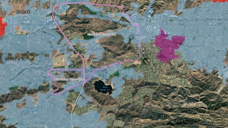
The map below is also a good way to stay updated on evacuations. You can see the full map here.
Areas outlined in pink above refer to mandatory evacuations, while shaded pink areas refer to wind-related power outages. Areas outlined in orange are voluntary evacuations and areas outlined in yellow refer to shelter-in-place locations. If an area is outlined in green later, that means the evacuation was lifted. Areas outlined in dark blue are under evacuation advisories, and light blue refers to resident access only. Shaded red regions refer to active PSPS regions.
The Ronald Reagan Presidential Library was already evacuated because of the fire.
Easy Fire Live Stream Videos
The fire in Ventura County first started on October 30 in Simi Valley near West Easy Street and West Los Angeles Avenue.
Here are live stream videos showing the fire’s growth. They should convert to rewatchable videos once the live stream finishes. The first is from NBC LA.
And ABC 7.
And Fox 11:
The cause of the Easy Fire is not yet known.
Many wildfires are burning in California today. This past week, the Getty Fire and the Kincade fire were among the fires causing the greatest damage and the most evacuations.
READ NEXT: PG&E Power Shutdown: Best Memes