
The Ranch Fire in Tehama County, California started on the evening of Sunday, November 3 and quickly grew to be more than 400 acres in size, prompting evacuations. Read on to learn more details about the fire, see maps, evacuations, and how to stay updated on the latest.
Ranch Fire Size, Containment, & Maps of the Fire’s Location
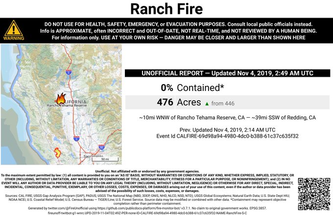
The Ranch Fire started on November 3 and is currently 476 acres as of 8:45 p.m., according to Ca.gov. But KCRTV reported that by 6:30 p.m., the fire was over 500 acres in size, which would make Ca.gov’s information a bit behind. YubaNet also lists 476 acres as the size with 0 percent containment.
The fire started southwest of Red Bluff, near Colyer Springs Road and Raglin Ridge Road. It grew from 20 acres around 2:15 p.m. to 476 acres by around 6:30 p.m.
#RanchFire 🔥 unofficial, automated update.
~10mi WNW of Rancho Tehama Reserve, CA. ⚠️ DO NOT USE FOR SAFETY PURPOSES – See officials instead. May be incorrect; disclaimers in images.
t.co/HJ0QY9sV0T
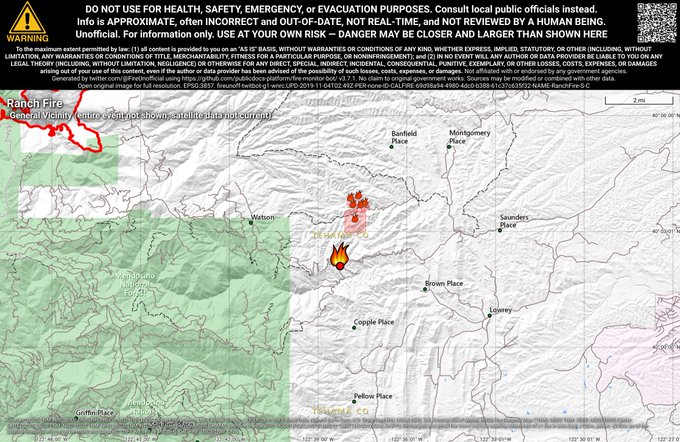
This satellite map below shows where the fire is burning.
#GOES17 is showing the #RanchFire burning in Tehama Co this afternoon. #cawx
This next map is an interactive map that shows satellite hotspot data for the Ranch Fire. This should not be used for emergency planning, since data in the map is typically about three hours old. The map is provided by MappingSupport.com. You can see the webpage with the map here.
Joseph Elfelt of Mapping Support noted on Twitter: “Interactive map for #RanchFire SW of Red Bluff, CA. Satellite hotspot data is several hours old. Map has 20+ #GIS overlay layers you can turn on/off/restack. Click top layer, see attribute data. Click Map tips for help. Open #GISsurfer map.”
And here is another map showing the fire’s location:
The#RanchFire burns hundreds of acres southwest of Red Bluff, Calif.
#wildfires t.co/Vn9Fa38sPC

Evacuations & Updates
The Tehama County Sheriff’s Office issued evacuation warnings for all of Colyer Springs Road to the Forest boundary, up north to Mary Ellen Place, and with an eastern boundary of Red Bank Road. Note that this was an advisory and not an evacuation order, KCRTV reported at 5:15 p.m. That means residents in the area should be ready to leave at any time.
EVACUATION WARNINGS: The Tehama County Sheriff’s Office has issued an evacuation warning for all of Colyer Springs Road to the forest boundary, north up to Mary Ellen Place and the eastern boundary over to Red Bank Road because of the #RanchFire
The evacuation warnings are about 40 minutes west of Red Bluff. As of 9:00 p.m., no structures had been destroyed from the fire.
Here are photos of the fire.
And here is a 5.5 hour time lapse of the fire:
#RanchFire #TehamaCounty @CALFIRETGU Last 5.5 hour time lapse of the fire.
For Air Alerts in your region, sign up here. This is specifically for southern California residents. You can see a map of air quality reports on AQMD’s page here. You can also view the map below. You can see a map of the current Red Flag Warnings in California provided by MappingSupport.com here.
Meanwhile, PG&E has restored power to most of its customers after the third major power shutoff since early October. However, shutoffs could happen again if another major wind event comes to California.
To stay updated on the fire, a number of sources can help. CA.gov is posting updates periodically. YubaNet is also posting updates here.
The Ranch Fire is one of a number of fires burning in California over the last few days. Other fires of concern include the Maria Fire and an Atwater Village fire that caused smoke and unhealthy air quality conditions in parts of the state.