Florida Forest Service
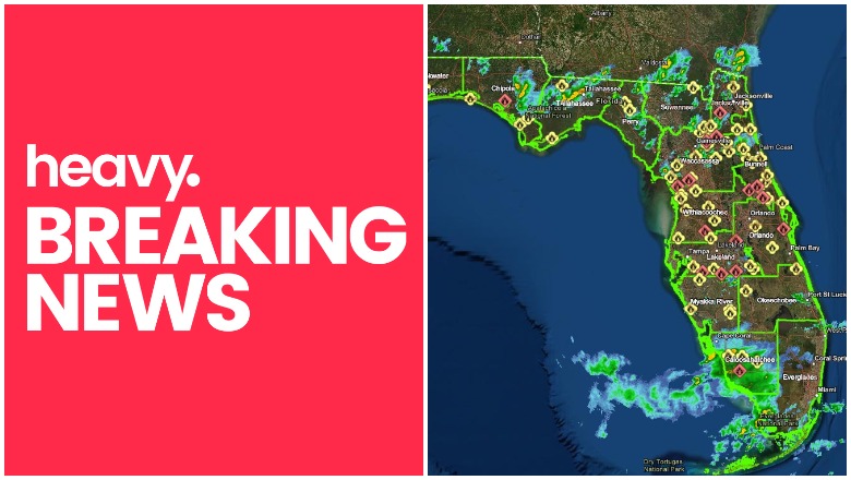
A number of wildfires have been burning in Florida for the past week. Read on to see a map, photos of the fires, and more details about where they are located as of Saturday, May 23.
Florida Fire Maps
You can see a wildfire dashboard of all the current active wildfires in Florida at this link. An embedded version is below. This map is updated every six hours at 6 p.m., 12 p.m., 6 a.m., and midnight. It’s provided by Florida government agencies.
And here’s another map, provided by the Florida Forest Service. You can see the full dashboard here.
You can also see a map of wildfires provided by the NWCG here. Zoom in to get a better look at the fires in Florida.
According to the dashboards, there are 79 active wildfires (contained and not contained) in Florida as of May 23, including 18 that are not contained. The fires total 14,384 acres in the state.
Here’s a list of some of the fires that are not contained in the state:
- 36th Ave SE Fire – 8,663 acres (but 98% or more contained)
- Live Oak Fire – 3 acres
- Peoples Fire – 300 acres
- Winterhill Road Fire – 122 acres
- 6.5 Reburn Fire – 53.6 acres
- Kingstree Dr. Fire – 41.5 acres
- Balu Fire – 24.5 acres
- North Grange Hall 2 Fire – 20 acres
- Bryce Fire – 15 acres
- SW 49th Dr Fire – .10 acres
- Hontoon Rd. Fire – 6.5 acres
- Acorn Fire – .3 acres
- Rosetine Fire – 1 acre
- Larkin Lake Fire – 2.2 acres
- Crescent Valley Ranch Fire – 1.3 acres
- Brooks Ridge Fire – 10 acres
Here are more details on those fires, listed in alphabetical order below:
36th Ave SE Fire
#36thAveSEFire Final Update. Complete update and map attached. @FLForestService @CollierSheriff @NCFRPio @CollierPIO @CollierEM @GN_Fire @MarcoIslandFire
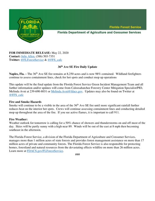
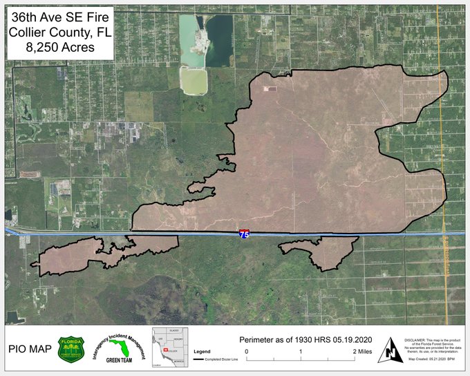
According to the Florida Disaster Map, this fire is 8,663 acres in size in Collier County. The good news is this appears to be 98% contained at least and is under control to the point that local sources are no longer providing updates.
6.5 Reburn Fire
According to the Florida Disaster Map, this fire is 53.6 acres in Levy County.
Acorn Lake Fire
This fire is .3 acres in Volusia County.
Balu Fire
According to the Florida Disaster Map, this fire is 24.5 acres in Alachua County.
Brooks Ridge Fire
This fire is 10 acres in Polk County.
Bryce Fire
According to the Florida Disaster Map, this fire is 15 acres in Clay County.
Crescent Valley Ranch Fire
This fire is 1.3 acres in Polk County.
Hontoon Road Fire
This fire is 6.5 acres in Lake County.
Kingstree Dr. Fire
According to the Florida Disaster Map, this fire is 41.5 acres in Volusia County.
Larkin Lake Fire
This fire is 2.2 acres in Pasco County.
Live Oak Fire
This fire is 3 acres in Clay County, according to Florida Disaster Map.
North Grange Hall 2 Fire
According to the Florida Disaster Map, this fire is 20 acres in Hillsborough County.
Peoples Fire
According to the Florida Disaster Map, this fire is 300 acres and located in Polk County.
Rosetine Fire
This fire is 1 acre in Brevard County.
SW 49th Dr. Fire
This fire is .10 acres in Marion County.
Winterhill Road Fire
Florida Forest Service helicopter pilot explains wildfire suppression tactics. @FLForestService #WinterHillRoadFire @BOCCPIO @BayCountyEM
According to the Florida Disaster Map, this fire is 122 acres in Bay County.
Remember: fire details can change quickly. If there is a fire near you, it’s a good idea to watch local news closely for changes.
READ NEXT: Daily COVID-19 Updates