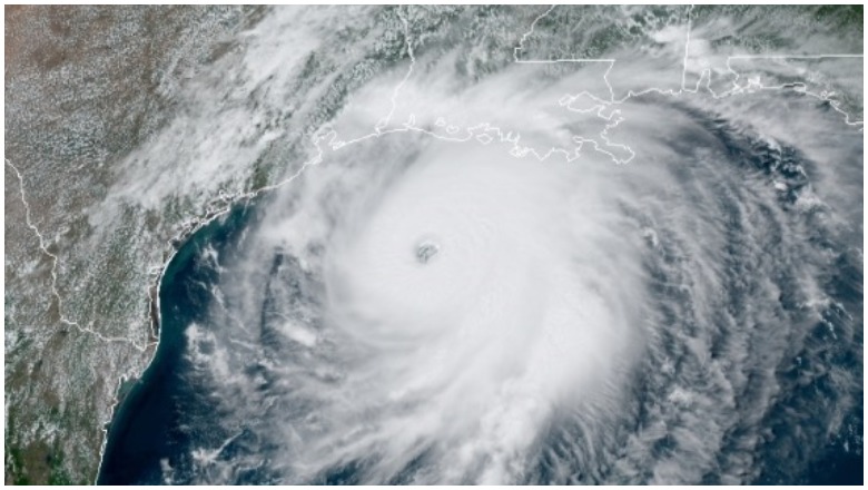
National Hurricane Center Hurricane Laura satellite image
Hurricane Laura has just strengthened to a Category 4, and people are already wondering if it might strengthen to a Category 5 by the time it makes landfall. Some experts are saying it’s possible, but hurricanes are notoriously hard to predict.
Meteorologists Are Saying It’s Possible that Laura Could Strengthen to a Category 5, But It’s Not Guaranteed
Kaitlyn McGrath, a meteorologist for NBC Connecticut, noted on Twitter that strengthening to a Category 5 wasn’t out of the question before Hurricane Laura’s landfall.
#Laura is an absolute beast and still strengthening. The eye is now really well defined and the hurricane is well on it’s way to becoming a category 4 this afternoon. I don’t think a category 5 is out of the question prior to landfall.
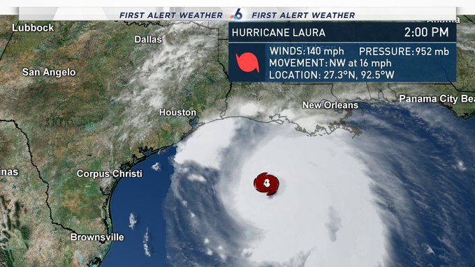
On the Saffir-Simpson Hurricane Wind Scale, a Category 5 requires winds of 157 mph or higher, while a Category 4 is 130 to 156 mph winds. As of the National Hurricane Center’s latest update for Laura released at 1 p.m. on August 26, the storm had 140 mph winds. So at that time, it still had quite a way to go before reaching Category 5 status. But the storm’s rapid strengthening has made Category 5 a possibility, although not assured.
Steve MacLaughlin, a meteorologist for NBC 6, tweeted that Laura was becoming “eerily similar to Hurricane Michael when it was approaching the Florida Panhandle and exploded into a Category 5 very quickly at the last moments before landfall.”
Wow. Hurricane Laura is now a Category 4 monster with winds up to 140mph. This is becoming eerily similar to Hurricane Michael when it was approaching the Florida Panhandle and exploded into a Category 5 very quickly at the last moments before landfall. #nbc6 #hurricanelaura
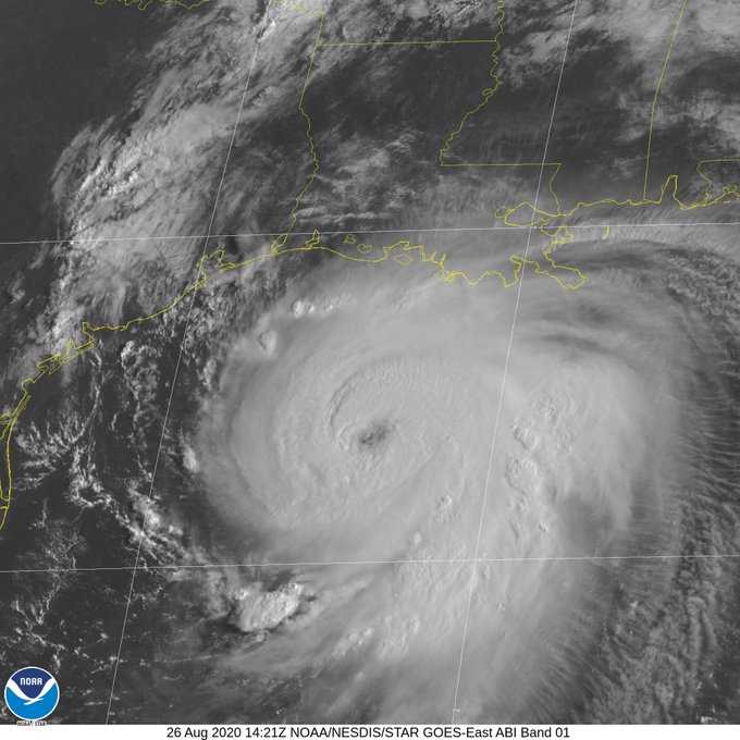
Ryan Maue, a meteorologist, tweeted earlier in the morning, before the storm was a Category 4, that the eye appeared to be clearing, which can help with intensification, and the pressure was dropping quickly. However, the pressure would need to drop a lot more to be consistent with a Category 5.
Pressure quickly dropping through the 950s (mb) with Hurricane Laura. The eye appears to be clearing — a characteristic of the most intense hurricane is a clear eye.
Pressure in the 940s (mb) is typical of strong Category 4 hurricanes.
920s (mb) is usually Category 5.
Maue later tweeted that the cloud tops would need to be colder. He wasn’t sure if Laura would intensify all the way to a Category 5 before landfall, but it would be close.
He wrote: “Hurricane Laura is not (yet) Category 5. Cloud tops around the eye would need to be colder. It does have a ragged look that is typical of still intensifying hurricanes. But, as with Michael (2008) that hit Florida panhandle, Laura could become Category 5 or close to it.”
Hurricane Laura is not (yet) Category 5.
Cloud tops around the eye would need to be colder. It does have a ragged look that is typical of still intensifying hurricanes.
But, as with Michael (2008) that hit Florida panhandle, Laura could become Category 5 or close to it.

Accuweather predicted that Laura might strengthen to Category 5.
The intense hurricane’s destructive storm surge could reach up to 30 miles inland and winds could leave people without power for weeks — and Laura may even reach Category 5 intensity for a time before approaching land.

Category 4 & Category 5 Are Both Dangerous Hurricanes
The Saffir-Simpson Hurricane Wind Scale, a Category 5 is described this way: “Catastrophic damage will occur: A high percentage of framed homes will be destroyed, with total roof failure and wall collapse. Fallen trees and power poles will isolate residential areas. Power outages will last for weeks to possibly months. Most of the area will be uninhabitable for weeks or months.”
A Category 4 is described this way: “Catastrophic damage will occur: Well-built framed homes can sustain severe damage with loss of most of the roof structure and/or some exterior walls. Most trees will be snapped or uprooted and power poles downed. Fallen trees and power poles will isolate residential areas. Power outages will last weeks to possibly months. Most of the area will be uninhabitable for weeks or months.”
So even if Laura does not become a Category 5, the storm is still very dangerous and should be taken seriously. Either category can leave serious damage in its wake. If you’re near the hurricane, listen to your local emergency officials and follow any evacuation protocols. Hurricane situations can change rapidly with little warning, so stay tuned to your local news for the latest updates.
READ NEXT: The latest COVID-19 deaths, cases, and updates