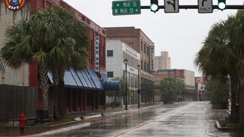
Getty A main street is empty as people seek safe shelter before the arrival of Hurricane Laura on August 26, 2020 in Lake Charles, Louisiana.
Hurricane Laura made landfall around 1 a.m. on Thursday morning, near Cameron, Louisiana, as a high Category 4 hurricane, the National Hurricane Center (NHC) reported. At the time of landfall, it was classified by the NHC as an “extremely dangerous category 4 hurricane” with “catastrophic storm surge, extreme winds, and flash flooding” expected overnight along the Gulf Coast. At noon on August 27, Laura was downgraded to a Tropical Storm by the NHC.
Photos and videos of the extreme weather began circulating on social media hours before Hurricane Laura’s landfall, with more coming afterward showing the storm’s power and damage. Below are some of the top photos and videos of Hurricane Laura’s damage.
Photos and videos specifically of the storm surge can be found here.
Photos & Videos Showed the Damage From the Storm Beginning in the Early Hours of Thursday Morning, With More Images Coming as the Day Went On
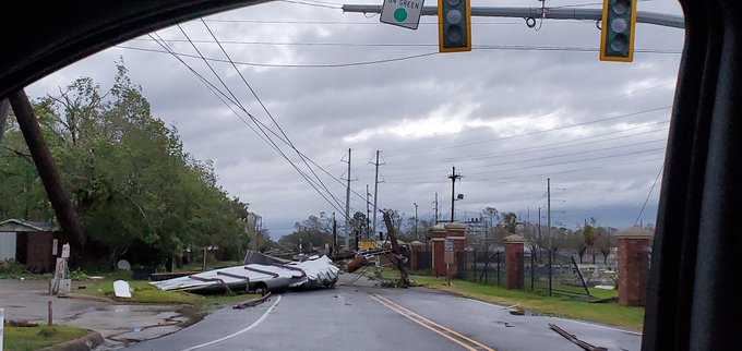
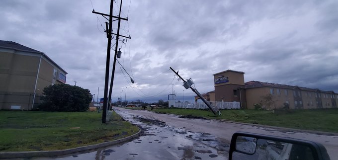
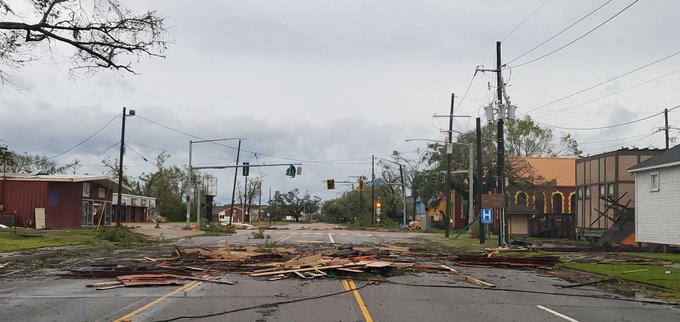
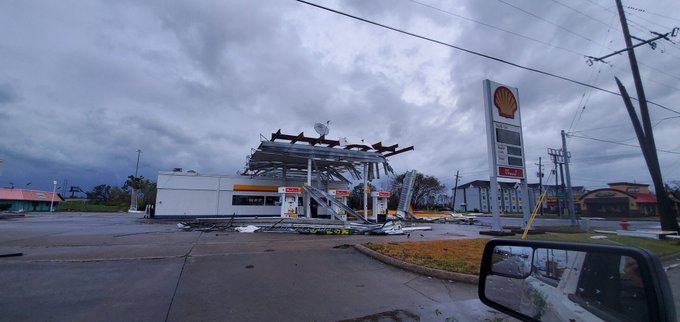
Here are some of the photos and videos of the damage caused by Hurricane Laura. The first series of photos and videos are of Lake Charles, Louisiana, which was significantly damaged. Damage in other areas is available after. An aerial video, courtesy of Live Storms Media, showing the damage to Lake Charles, Louisiana, was shared by Todd Yakoubian of KATV:
Disaster Response Team TE2C making their way through some of the hardest-hit areas across Lake Charles, Louisiana after Hurricane Laura!
Permission: Tough Enough 2 Care from Granbury, TX
@WeatherBug – Download the app today!
Storm chaser Aaron Rigsby posted a series of photos:
Plaza after plaza demolished in Lake Charles #Laura
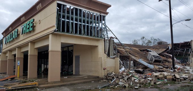
Significant damage all over Lake Charles #Laura

#BREAKING: This is Lake Charles, #Louisiana in the early morning! Motel partially destroyed by hurricane #Laura!
#HurricanLaura #HurricaneLaura #HurricaneSeason #laurahurricane #HurricanLaura #lakecharleslouisiana #hurricainelaura #LakeCharles #AllLivesMatter #HurricaneLaura2020
Some shots were shared of damage to apartments:
Daylight shows damage to LaQuinta Inn in Lake Charles:
Finally able to venture out. Massive damage to this LaQuinta Inn in Lake Charles.

A shot of the damage at Golden Nugget, Lake Charles:
Security stand/canopy tumbled right over at Golden Nugget. Hurricane #Laura @weatherchannel
A communication tower in Lake Charles collapsed, pictured by John Humphress with Severe Studios:
Large communication tower collapsed in Lake Charles, LA during Hurricane #Laura
– @johnhumphress
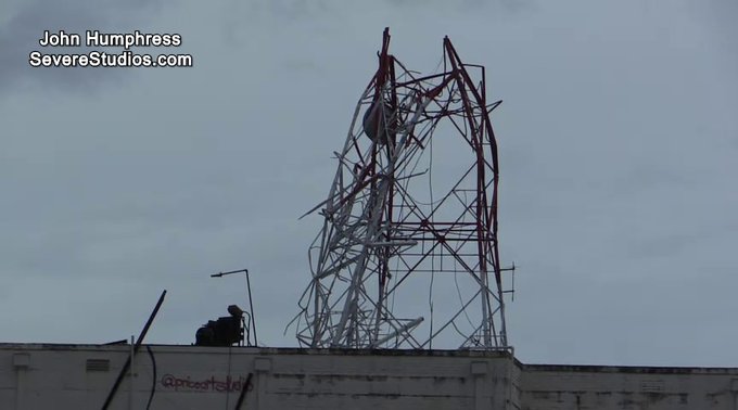
The tower fell through the roof of our sister station KPLC in Lake Charles. #Laura

Some of the Westlake area in Louisiana, north of Lake Charles:
First light revealing sad scenes around the West Lake area after #Laura #HurricaneLaura2020. Poorly built structures did not fare well

.@RepAbraham surveying damage between Lake Charles and DeRidder. ‘Very little untouched. Roads are like obstacle course’ #Laura #lagov #la05
A team traveling to Cameron, Louisiana, near where the hurricane made landfall, posted this video of the damage and flooding in the streets:
Team en route to #Cameron. Damage getting worse along the way. #laura #hurricanelaura2020
Storm chaser Reed Timmer shared the devastation and storm surge effects in Hackberry, Louisiana:
Terrible devastation in Hackberry, LA mainly wind damage but also evidence of strong storm surge. Weaker structures obliterated. @RadarOmega_WX #HurricaneLaura
Terrible damage to homes in Hackberry, LA from #HurricaneLaura
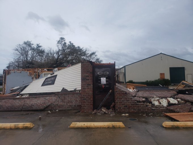
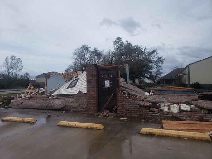
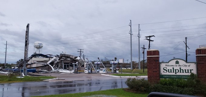
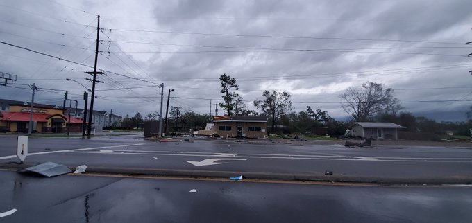
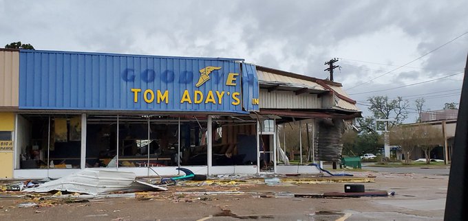
Photos of Sulphur, Louisiana, showed damage to buildings and homes in that area:
Damage throughout the town of Sulphur, Louisiana after Hurricane #Laura. Most roads are impassable and covered with debris.
Structural damage from Hurricane #Laura in Sulphur, Louisiana. Could not get to some of the worst areas. Businesses and homes heavily damaged.
Delcambre, Louisiana, appeared to have some significant flooding in its streets:
Heartbreaking.
New video shows people wading through floodwaters after Hurricane Laura moved through Delcambre.
More on Tropical Storm Laura >> t.co/O9IOhxgBMV
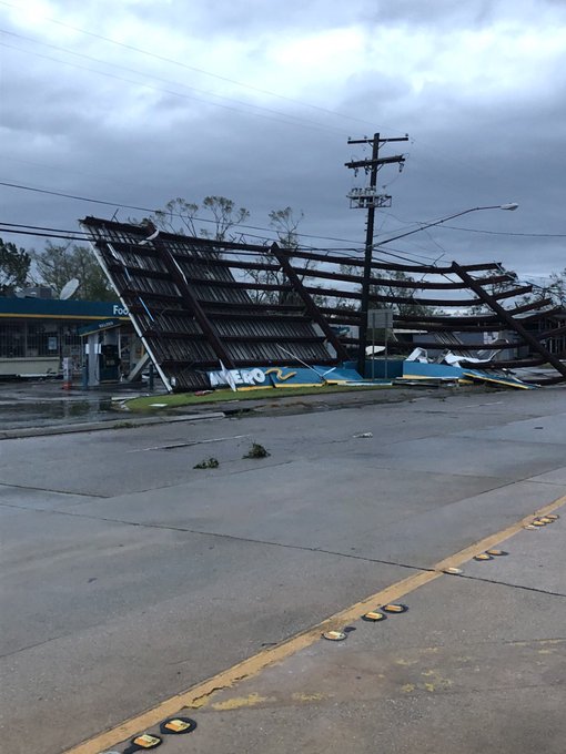
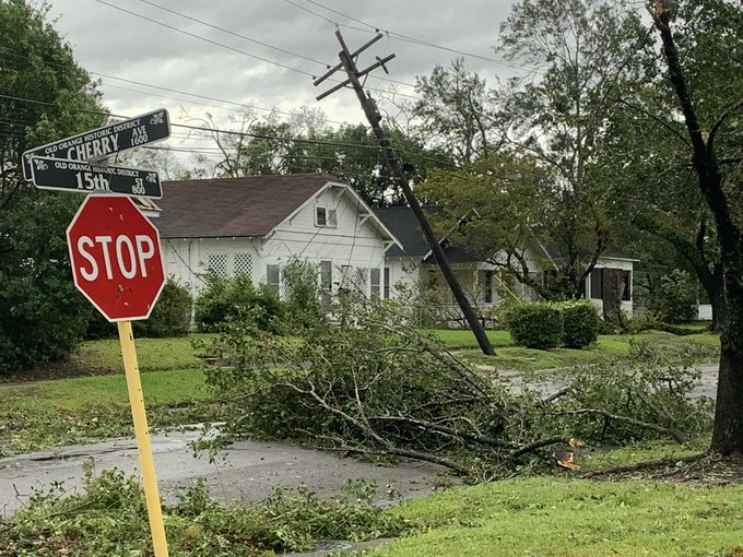
There was also some damage reported in Orange, Texas, near the Louisiana border:
First look at the damage in Orange. #laura #ksatstormchaser


Officials Reported a Fire at a Chemical Plant in Westlake & Issued Shelter-in-Place Orders for Westlake, Sulphur & Moss Bluff
KPLC reported that authorities are warning of a fire at a chemical plant in Westlake. The outlet reports that Sulphur, Westlake and Moss Bluff are under orders to shelter in place and avoid the I-10 through Westlake. Here are some videos of the smoke:
Huge chemical fire just off I-10 in Lake Charles,LA
BREAKING – an emergency alert just came through cell phones in the Lake Charles/Westlake area warning of a plant fire. Westlake residents are asked to shelter in place, close doors, windows and shelter in place. #HurricaneLaura
Chemical fire in Westlake near Lake Charles following Hurricane Laura. #HurricaneLaura2020 #hurricane
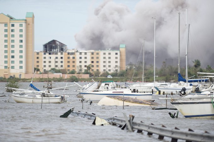
This is a different view of the chemical fire in Lake Charles.
According to @DialDalfredKLFY, his sources say this is a bio lab that makes cleaning products.
Some of the Earlier Images Came During the Storm Overnight, Mostly in the Lake Charles Area
Storm chaser Reed Timmer posted a video of damaged buildings in Lake Charles, Louisiana with all their windows shattered in high winds:
NEW: buildings completely gutted, glass falling everywhere in downtown Lake Charles, LA in the eye of #HurricaneLaura @RadarOmega_WX
Storm chaser Jeff Piotrowski also shared an image of a damaged high rise in Lake Charles:
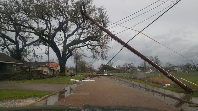
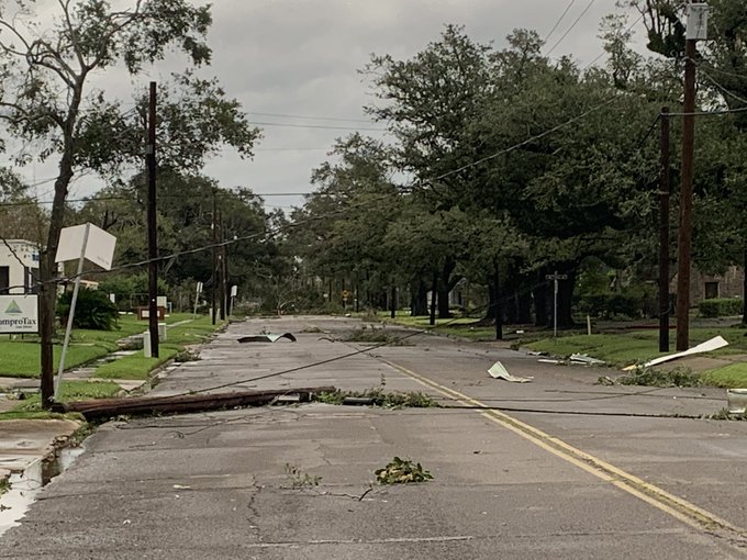
Storm chaser Brian Emfinger shared some early shots of damage overnight in Lake Charles with reports of downed power lines:
Damage is widespread in Lake Charles. It’s also very difficult to get around due to all of the downed power lines and trees. The interstates have multiple blockages of power lines and light poles with the smaller roads even worse. #HurricaneLaura #lawx
More shots from Timmer show the debris flying during the storm:
EYE WALL of powerful #HurricaneLaura in Lake Charles, LA with the Dominator Fore and HERV taking some debris. Sadly there is a lot of damage, likely catastrophic to the south. We are waiting for sunrise to drive to Holly Beach and retrieve windy palms @MikeTheiss
BREAkING! Buildings gutted in Lake Charles LA in powerful eye wall of #HurricaneLaura @RadarOmega_WX @ChasinSpin
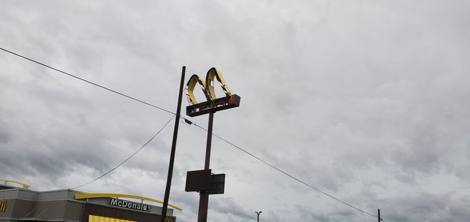
The force of the winds could be seen:
Many people watched on various feeds of the storm as the Wendy’s sign in Lake Charles got destroyed — more on that here.
The 1 A.M. Update From the NHC Warned of ‘Extremely Dangerous’ Hurricane Laura as It Made Landfall
At 1 a.m. local time, the NHC warned of the storm’s catastrophic strength as it made landfall near Cameron, Louisiana. winds, with maximum sustained winds of 150 mph, which is just below the threshold for Category 5 hurricane status. This is the center’s update:
At 100 AM CDT (0600 UTC), Doppler radar images indicate that the eye of Hurricane Laura has made landfall at the coast near Cameron, Louisiana, near latitude 29.8 North, longitude 93.3 West. Laura is moving toward the north near 15 mph (24 km/h), and this motion should continue through the day. A northeastward to east-northeastward motion is expected tonight and Friday. On the forecast track, Laura will move inland across southwestern Louisiana this morning, and then continue northward across the state through this afternoon. The center of Laura is forecast to move over Arkansas tonight, and over the mid-Mississippi Valley on Friday, and the mid-Atlantic states on Saturday.
Air Force reconnaissance and Doppler radar data indicate that the maximum sustained winds are near 150 mph (240 km/h) with higher gusts. Rapid weakening is forecast as Laura moves inland.
READ NEXT: Hurricane Laura Storm Surge: All the Photos & Videos You Need to See