
NOAA A live map provided by NOAA of Henri.
Hurricane Henri is slowly making its way to New England, where it’s expected to make landfall sometime on Sunday. Where is the storm now? Read on to see live radar and maps of the storms.
Live Radar & Video Streams Reveal Henri’s Location
Live radar and maps can help you keep track of Henri’s current location and where the storm is moving. The storm is expected to strengthen over the next couple of days and make landfall in the New England region.
This first live radar, embedded below, is from Windy.com. This radar is one of the most helpful for tracking the location of Henri live. You can press the + button on the right side of the map to zoom in more closely. You can also move the map ahead in time to see where the storm is forecast to be headed. Depending on your browser, you might need to click on the map and drag it to see Henri’s location.
Google used to have crisis maps for tracking storms, but those have been phased out as of April 2021.
Another live storm tracker, from NowCoast at NOAA.gov, is here. While the map is not embeddable, it will provide live updates as the NOAA tracks the storm. It’s another good resource for tracking the storm in real-time.
You can also watch videos of live trackers. NBC News is provided one live tracker video below on YouTube. You can also watch the video here if the video below does not embed properly.
A video from NBC New York also shows updates on Henri, maps, and other information live. This YouTube video is not embeddable.
This next YouTube video shows several different views of the storm, and it also shows maps of Grace in addition to Henri.
A discussion on Reddit’s tropical storm subreddit is also providing updates on Henri, including a variety of projection maps and paths.
CIRA is providing an enhanced infrared imagery map that it is updating here. You can see all of CIRA’s maps and models here.
Henri’s Projected Path
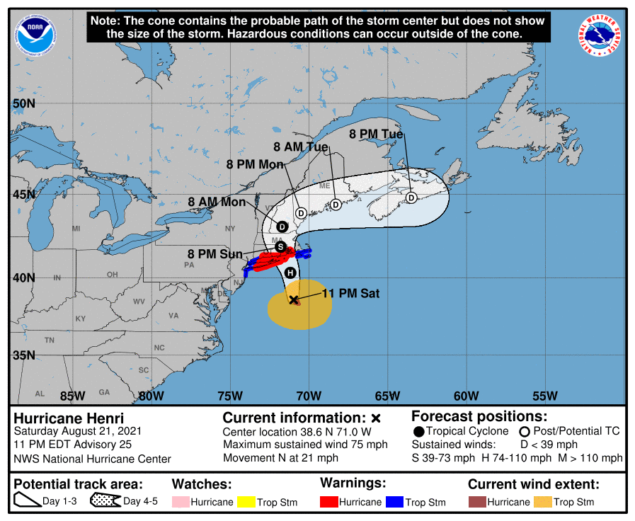
NHCNHC forecast as of August 21 at 11 p.m. Eastern.
As of 11 p.m. Eastern on Saturday, August 21, the National Hurricane Center (NHC) provided a map of Henri’s projected path, which you can see above or via the link here.
As of 11 p.m., Henri was located at 38.6 N, 71.0 W, about 220 miles south of Providence, Rhode Island, and about 180 miles south-southeast of Montauk Point, New York. The storm was moving north (355 degrees) at 21 mph.
The National Hurricane Center noted at 11 p.m.:
Henri is moving toward the north near 21 mph (33 km/h) and this motion is expected to continue through tonight. A decrease in forward speed and a turn toward the north-northwest is expected on Sunday. On the forecast track, Henri is expected to make landfall in southern New England or on Long Island on Sunday. After landfall, a turn to the north and a slower forward speed are expected as Henri moves over southern New England.
Reports from NOAA and Air Force Reserve Hurricane hunter aircraft indicate that maximum sustained winds are near 75 mph (120 km/h) with higher gusts. Slight strengthening is possible tonight. Weakening is expected on Sunday. However, Henri is expected to be at or near hurricane strength when it reaches the coasts of southern
New England and Long island. Rapid weakening is expected after Henri makes landfall.Hurricane-force winds extend outward up to 35 miles (55 km) from the center and tropical-storm-force winds extend outward up to 150 miles (240 km).
In a more detailed discussion from NHC, which you can read here, forecasters also reported at 11 p.m.:
The convective pattern associated with Henri is less ragged than it was 6 h ago, as the convection has increased near the center and a NOAA Hurricane Hunter aircraft reported a 25 n mi wide eye has formed However, the hurricane has not yet strengthened significantly, as the maximum winds remain about 65 kt in the southeastern eyewall and the central pressure is near 987 mb.
Henri has moved a little to the right of the previous track at 18-20 kt during the past several hours. However, the cyclone now seems to be moving northward with an initial motion of 355/18 kt. There is no change to the forecast track philosophy. A cut-off low located over the central Appalachians and a ridge building to the east and northeast of Henri should cause the storm to move generally northward tonight. A turn toward the north-northwest and a slower forward speed are expected on Sunday, which should bring the center near or over southern New England or Long Island between 18-24 h. With the more eastward initial position, the forecast track is shifted a bit to the east of the previous forecast. However, there is still some uncertainty of the landfall point, as
several of the guidance models are to the left of the official forecast. After landfall, Henri should slow its forward speed and turn eastward as it become steered by the mid-latitude westerlies. Users are reminded to not focus on the exact forecast track, as the average 24-hour track uncertainty is around 40 miles and impacts will extend well away from the center.Henri is almost out of time to strengthen, as the center will be moving north of the north wall of the Gulf Stream during the next several hours. The intensity forecast will call for modest strengthening during the first 12 h based on the premise that strengthening will occur before Henri reaches the cooler waters. After that, while the cyclone should start to weaken before landfall, it should still be near or at hurricane strength when it reaches southern New England. Rapid weakening is expected after landfall, and Henri is again forecast to become post-tropical in about 48 hours and dissipate in 3 to 4 days.
READ NEXT: The latest COVID-19 variant details, cases, and vaccine updates