
Hurricane Harvey has dissipated from a Category 4 hurricane to a tropical storm, but the dangers to Houston, Texas are by no means over.
In Houston, there are concerns about heavy rainfall and strong winds, including the potential for tornadoes. Severe flooding was reported in the evening.
Flash floods had been feared for days, and the reality had arrived. Thousands of people were stranded inside their flooded homes in Houston and urban search and rescue efforts had already saved 300 people.
“Small creeks & streams, urban areas, highways, streets, underpasses, drainage areas and low lying spots especially susceptible to flooding!” warned the National Weather Service’s Houston office. NWS Houston also wrote the evening of August 26: “FLASH FLOOD EMERGENCY: Around & north Hobby Airport to Pearland & Friendswood. PARTICULARLY DANGEROUS SITUATION. DO NOT ATTEMPT TO TRAVEL!”
Gas station parking lots were flooded.
Houston, Pearland, and Pasadena TX were under a flash flood warning. Houston Mayor Sylvester Turner urged, “Please stay off the roads unless it is an emergency. You are safer at home.” He also wrote, “The weather system is very unpredictable but will produce rain over several days. Red Cross and City decided to open a few shelters now.”
Here is the latest Houston, Texas radar as of 11:15 p.m. on August 26.

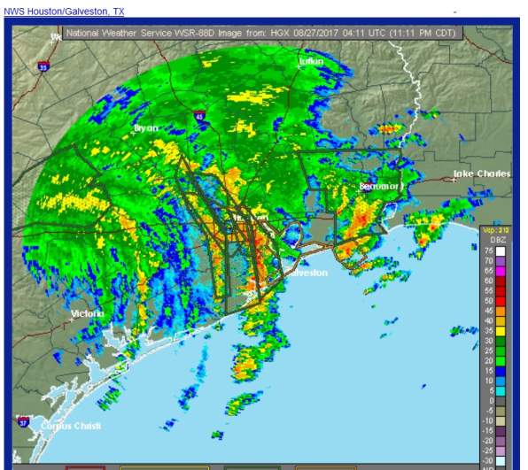
National Weather ServiceHouston radar.
The local outlook statement from the National Weather Service reported for Houston at 10:30 p.m. on August 26, “Tropical Storm Harvey is barely moving and still producing bands of very heavy rainfall with some embedded tornadoes tonight.”
https://twitter.com/_NZepeda_/status/901659834457710592
The outlook statement continued, “Prolonged extreme heavy rainfall and widespread flash flooding is the primary threat to Southeast Texas.”
“Numerous flash flood warnings have already been issued across the area, and widespread flooding is likely to continue over the next 3 to 5 days. Tornadoes have also been occurring across Southeast Texas over the last day or so and will likely continue through the next several days,” The NWS reported.
The statement continued, “Coastal flooding may be an ongoing issue along the coast where winds will continue to push water onshore, particularly south of Sargent. Elevated tides will cause the recession
of coastal flood waters to be slow, likely lasting into the first part of the week.”
Wind is also a concern. The statement noted, “Wind gusts to tropical storm force are still ongoing, primarily in the southwestern portions of the area towards Matagorda Bay. Though there are currently multiple hazards present across the area, the greatest threat to life and property remains the potential for extreme rainfall and subsequent prolonged and potentially catastrophic flash flooding well into next week.”
The National Weather Service said in its earlier August 26 hazardous weather report for Houston that “rainbands from Harvey will produce gusty winds, locally heavy rainfall and associated flooding, and isolated tornadoes. Flooding will occur as rainfall totals could approach or exceed 10 to 15 inches.”
A tornado watch was issued for August 26.
Starting Sunday, August 27, reports the NWS, “Harvey is expected to meander in and around the Southeast Texas area for several days and produce round after round of showers and thunderstorms. Rainfall totals (including today`s and tonight`s 10 to 15 inches) will be adding up with event amounts of 15 to 30 inches expected and isolated maximum totals of 40 inches possible. The greatest threat area is expected to be generally along and south of a line from Brenham to Conroe to High Island. Rainfall of this magnitude will cause catastrophic and life-threatening flooding.”
There were some power outages reported in Houston:
See the hourly forecast for Houston here.
See current warnings and hazardous weather outlooks for Houston here.
Get an updated list of Houston closings here.
The local statement for Houston on Hurricane Harvey reads on August 26 at just after noon:
* CURRENT WATCHES AND WARNINGS:
– A Tropical Storm Warning and Storm Surge Watch are in effect
for Chambers and Harris
– A Tropical Storm Warning is in effect for Austin, Colorado,
Fort Bend, Liberty, Waller, and Wharton
– A Storm Surge Warning and Tropical Storm Warning are in effect
for Brazoria, Galveston, Jackson, and Matagorda
* STORM INFORMATION:
– About 80 miles west-northwest of Matagorda TX
– 28.9N 97.3W
– Storm Intensity 75 mph
– Movement North or 350 degrees at 2 mph
You can read the Houston/Galveston hurricane guide for 2017 here.
The detailed weather forecast for Houston from the National Weather Service is as follows:
Saturday August 26 afternoon:
“Showers and thunderstorms. Some of the storms could produce gusty winds and heavy rain. High near 80. Windy, with an east wind 20 to 25 mph, with gusts as high as 30 mph. Chance of precipitation is 100%. New rainfall amounts between 2 and 3 inches possible.”
Tonight
“Showers and thunderstorms. Some of the storms could produce heavy rainfall. Low around 76. Windy, with an east wind 20 to 25 mph, with gusts as high as 30 mph. Chance of precipitation is 100%. New rainfall amounts in excess of 4 inches possible.”
Sunday
“Showers and thunderstorms. Some of the storms could produce heavy rainfall. High near 81. Windy, with an east wind 20 to 25 mph, with gusts as high as 30 mph. Chance of precipitation is 80%. New rainfall amounts in excess of 4 inches possible.”
Sunday Night
“Showers and thunderstorms. Some of the storms could produce gusty winds and heavy rain. Low around 73. Breezy, with a northeast wind 15 to 20 mph, with gusts as high as 30 mph. Chance of precipitation is 80%.”
Monday
“Showers and thunderstorms. Some of the storms could produce heavy rain. High near 80. East wind around 15 mph, with gusts as high as 20 mph. Chance of precipitation is 80%.”
Monday Night
“Showers and thunderstorms likely. Cloudy, with a low around 72. Chance of precipitation is 70%.”
Tuesday
“Showers and thunderstorms likely. Cloudy, with a high near 82. Chance of precipitation is 70%.”
Tuesday Night
“Showers and thunderstorms likely. Cloudy, with a low around 74. Chance of precipitation is 70%.”
Wednesday
“Showers and thunderstorms likely. Cloudy, with a high near 84. Chance of precipitation is 60%.”
Wednesday Night
“A 50 percent chance of showers and thunderstorms. Mostly cloudy, with a low around 75.”
Thursday
“A 50 percent chance of showers and thunderstorms. Mostly cloudy, with a high near 86.”
Thursday Night
“A 20 percent chance of showers and thunderstorms. Mostly cloudy, with a low around 75.”
Friday
“A 20 percent chance of showers and thunderstorms. Partly sunny, with a high near 89.”