(National Hurricane Center)
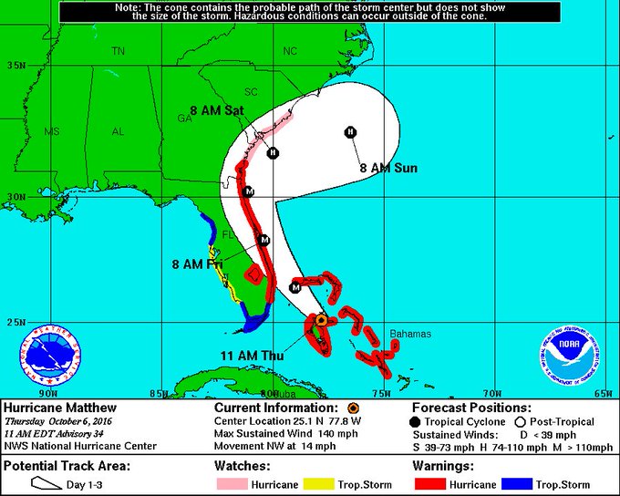
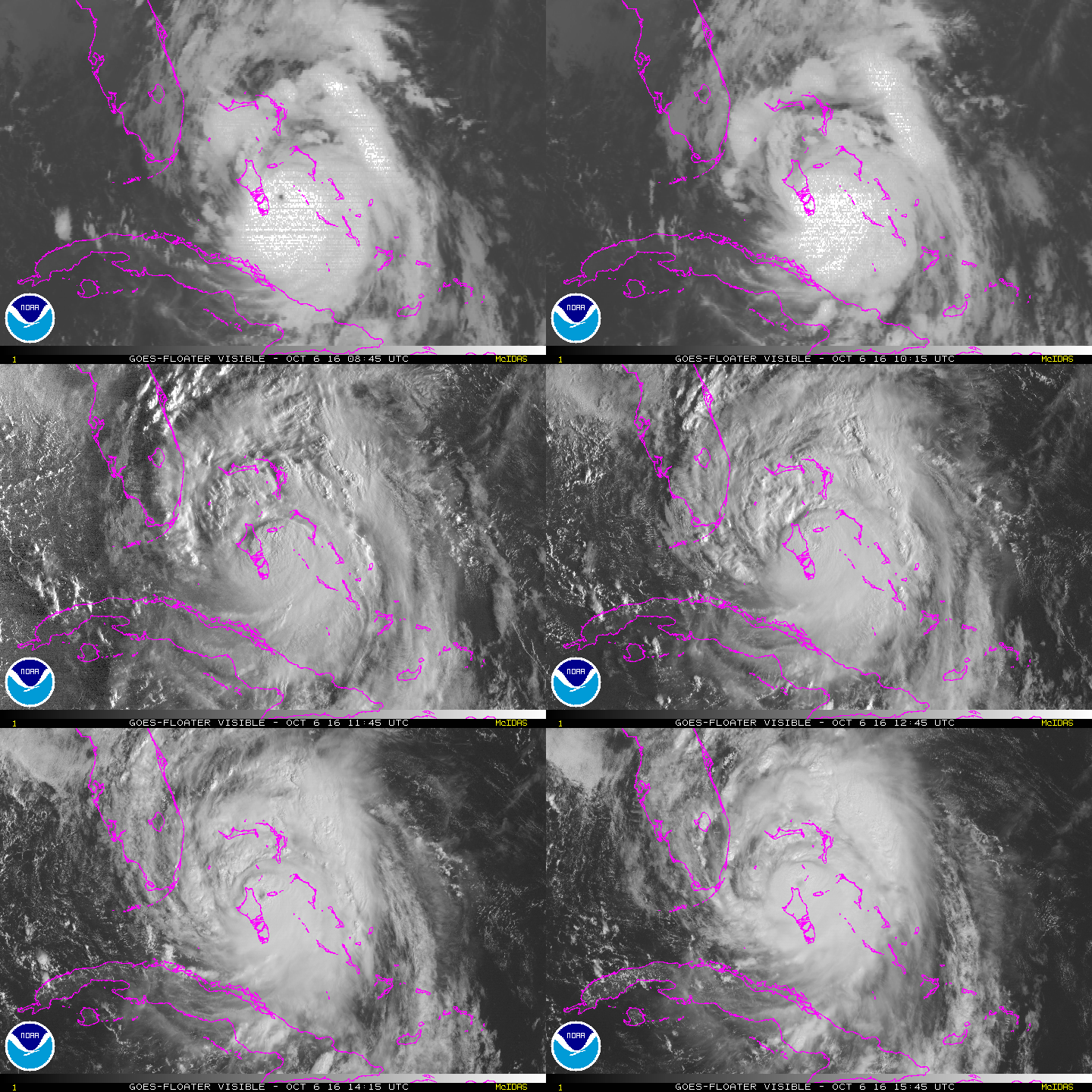
Hurricane Matthew has been upgraded to a deadly Category 4 storm as it churns through the Atlantic Ocean and barrels toward the Florida coast.
“Matthew’s eyewall will likely rake a sizable swath of Florida East Coast, as at least Category 4 intensity, and is probable to pass near enough to the coasts of Georgia and South Carolina to bring hurricane conditions to those areas as well,” The Weather Channel says. “These may be the strongest, most destructive winds experienced along parts of the Florida east coast in decades, and may be of a magnitude not seen by many residents along the east-central and northeast Florida and Georgia coasts.”
Millions along the East Coast, from Florida to Georgia to South Carolina and beyond, are being evacuated from their homes as the storm moves toward them.
“This storm will kill you,” Florida Governor Rick Scott told residents in the storm’s path. “Time is running out. We don’t have that much time left.”
Category 4 hurricanes are among the most powerful storms, producing high winds, heavy rain and life-threatening flooding. Here’s what you need to know about them:
1. Category 4 Storms Have Sustained Wind Speeds Between 130 to 156 MPH
Hurricanes are ranked from Category 1, the least powerful, to Category 5, the most powerful by the Saffir-Simpson Hurricane Wind Scale, according to the National Weather Service.
“The Saffir-Simpson Hurricane Wind Scale is a 1 to 5 rating based on a hurricane’s sustained wind speed. This scale estimates potential property damage,” the weather service says. “Hurricanes reaching Category 3 and higher are considered major hurricanes because of their potential for significant loss of life and damage.”
Category 4 hurricanes have sustained wind speeds ranging between 130 to 156 mph.
2. Hurricanes at Category 4 Strength Cause ‘Catastrophic Damage,’ Including Damages to Homes & Widespread Power Outages
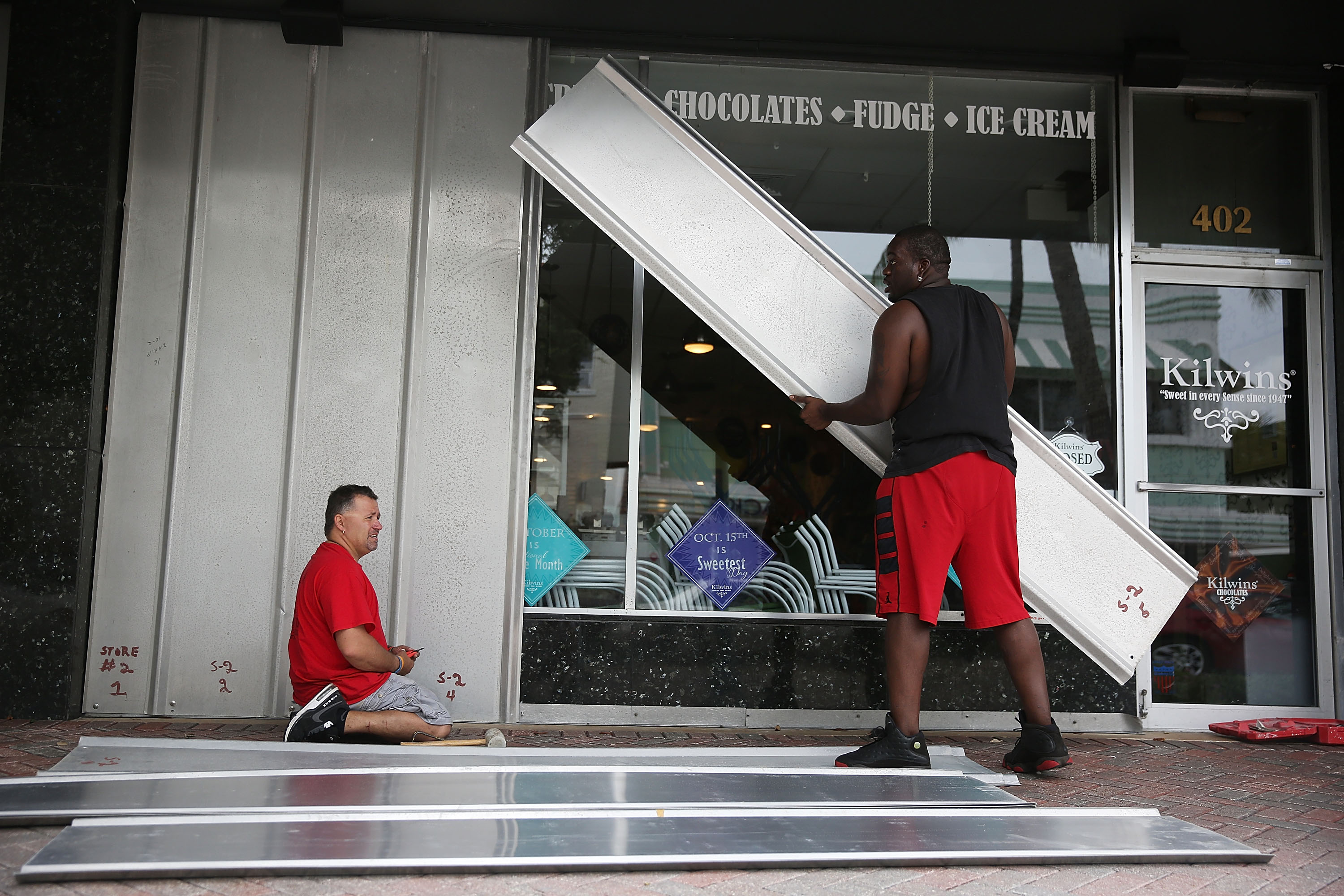
Jason Brock and Kevin Hunter put up hurricane shutters in front of a business as Hurricane Matthew approaches the area on October 6, 2016 in Delray Beach, Florida. (Getty)
Hurricanes at Category 4 strength cause “catastrophic damage,” according to the wind speed scale, according to the National Hurricane Center:
There is a very high risk of injury or death to people, livestock, and pets due to flying and falling debris. Nearly all older (pre-1994) mobile homes will be destroyed. A high percentage of newer mobile homes also will be destroyed. Poorly constructed homes can sustain complete collapse of all walls as well as the loss of the roof structure. Well-built homes also can sustain severe damage with loss of most of the roof structure and/or some exterior walls. Extensive damage to roof coverings, windows, and doors will occur.
Large amounts of windborne debris will be lofted into the air. Windborne debris damage will break most unprotected windows and penetrate some protected windows. There will be a high percentage of structural damage to the top floors of apartment buildings.
Steel frames in older industrial buildings can collapse. There will be a high percentage of collapse to older unreinforced masonry buildings. Most windows will be blown out of
high-rise buildings resulting in falling glass, which will pose a threat for days to weeks
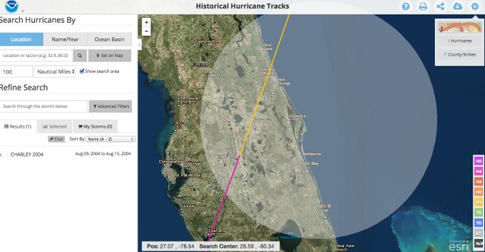
after the storm. Nearly all commercial signage, fences, and canopies will be destroyed. Most trees will be snapped or uprooted and power poles downed.Fallen trees and power poles will isolate residential areas. Power outages will last for weeks to possibly months. Long-term water shortages will increase human suffering. Most of the area will be uninhabitable for weeks or months. Hurricane Charley (2004) is an example of a hurricane that brought Category 4 winds and impacts to coastal portions of Punta Gorda, Florida with Category 3 conditions experienced elsewhere in the city.
3. Category 4 Hurricanes Also Bring Life-Threatening Storm Surges & Heavy Rain That Can Cause Flooding
While the hurricane wind speed scale, “does not address the potential for other hurricane-related impacts, such as storm surge, rainfall-induced floods, and tornadoes,” Category 4 storms have typically brought along the potential for life-threatening storm surges and heavy rain.
Forecasters are predicting similar impacts from Hurricane Matthew.
“The heaviest rainfall totals, possibly ranging between 5-12 inches, are likely to be confined to the immediate coast, from Florida to eastern North Carolina. There is a potential for even heavier rainfall if Matthew makes landfall,” The Weather Channel says. “The storm surge will also limit rainfall runoff, aggravating flooding, especially in coastal locations where swollen rivers cannot drain, backing up rivers potentially miles inland.”
According to the National Hurricane Center, the following storm surges could occur:
Sebastian Inlet, Florida to the Edisto Beach, South Carolina: 7 to 11 feet above ground level
Deerfield Beach, Florida to the Sebastian Inlet, Florida: 4 to 6 feet above ground level
Edisto Beach, South Carolina to South Santee River, South Carolina: 4 to 6 feet above ground level
Virginia Key, Florida to Deerfield Beach, Florida: 1 to 2 feet above ground level
4. The National Weather Service Says Matthew Is Likely Stronger Than Any Hurricane to Hit the East Coast in Recent Decades
(National Hurricane Center)
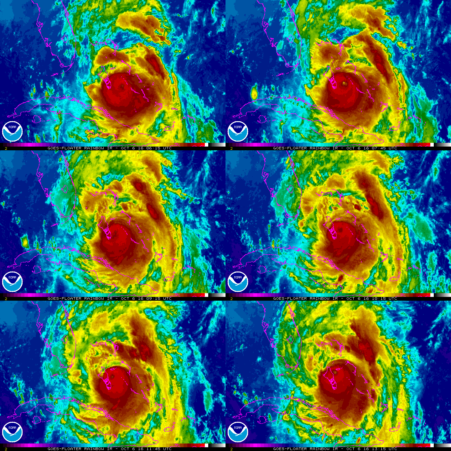
Hurricane Matthew could be stronger than any storm to hit the East Coast of the United States in recent decades, topping the trio of 2004 hurricanes, Charley, Frances and Jeanne, and Hurricane David in 1979, according to the National Weather Service.
“Widespread extensive to devastating wind impacts will be felt,” the NWS said in its advisory about the storm. “Airborne debris lofted by extreme winds will be capable of breaching structures, unprotected windows and vehicles. Effects such as these ranging from the coast to well inland have not been experienced in Central Florida in decades.
“Local winds will exceed what occurred during the hurricanes of 2004. Any evacuations and structure preparation should be completed (Thursday) afternoon. Travel will be strongly discouraged beginning at dusk. Expect widespred power outages.”
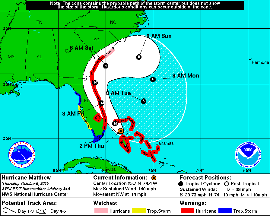
5. Matthew Would be the First Hurricane to Strike Florida Above Palm Beach
(National Hurricane Center)
Eric Blake, a hurricane specialist for the National Weather Service said Matthew would be the first Category 4 storm to make landfall in that area of Florida in recorded history.
According to The Weather Channel, the only Category 4 storm to make landfall that far north along the East Coast was in 1898 south of St. Simons Island in Georgia.
