While Hurricane Harvey has dissipated to the point where it’s a tropical storm, there are still dangers to the San Antonio area due to high winds and torrential rainfalls. While the Houston area has been dealt the brunt of the storm and flooding, what’s expected in San Antonio?
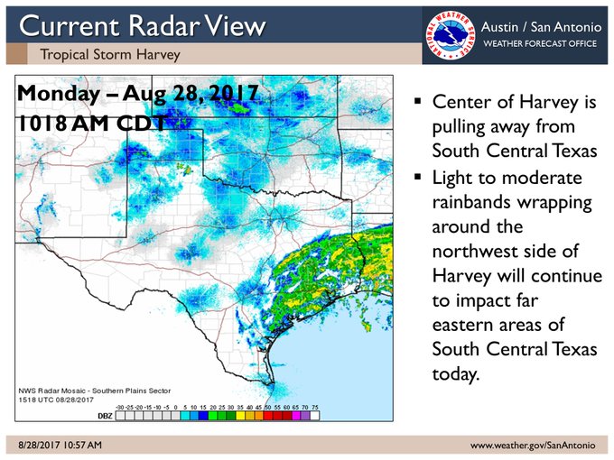
The Category 4 hurricane made landfall on Friday in Rockport, Texas and caused a steady amount of damage and injuries to at least 10 people. It moved the next day by about 75 MPH. Here’s a look at what the radar showed in San Antonio on Monday afternoon: light-to-moderate rainfall.
11:11a – Radar shows light to moderate rain wrapping around the NW side of the circulation. Heavy rain is far east of the area.
With the storm continuing to move away from South Central, Texas, the focus shifts to ongoing river flooding that’s impacting the city. San Antonio remains under a Flash Flood Watch, though all tropical warnings have now been canceled.
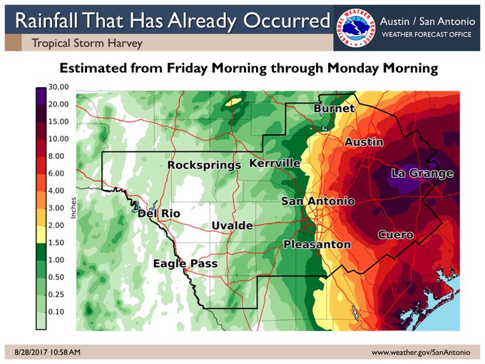
Here’s a look at the amount of rainfall that’s accumulated in the area.
11:14a 8/28 – Here is a graphic of Estimated Rainfall from Friday Morning through this morning.
The National Weather Service also issued an overview of the current situation in the San Antonio area. It said there’s still “life threatening flooding event ongoing in portions of Bastrop, Lee, Fayette, DeWitt, Gonzales and Lavaca Counties.”
You can see up-to-the-minute radar for San Antonio here.
Track the hour-by-hour forecast for San Antonio here.
See an updated watch and warning map here.
Here’s a list of updated closings and delays in San Antonio.
The August 28 local weather outlook for San Antonio from the National Weather Service reads as follows:
Monday Afternoon
“A 50 percent chance of showers and thunderstorms. Mostly cloudy, with a high near 83. North wind around 20 mph, with gusts as high as 25 mph. New rainfall amounts of less than a tenth of an inch, except higher amounts possible in thunderstorms.”
Monday Night
“A 40 percent chance of showers and thunderstorms. Mostly cloudy, with a low around 72. North wind 10 to 15 mph, with gusts as high as 20 mph.”
Tuesday
“A 30 percent chance of showers. Partly sunny, with a high near 85. North wind 10 to 15 mph, with gusts as high as 20 mph.”
Tuesday Night
“A 20 percent chance of showers. Partly cloudy, with a low around 73. North wind around 10 mph.”
Wednesday
“A 20 percent chance of showers. Partly sunny, with a high near 85. North wind 10 to 15 mph.”
Wednesday Night
“Mostly cloudy, with a low around 71. North wind 5 to 10 mph.”
Thursday
“A 20 percent chance of showers and thunderstorms. Partly sunny, with a high near 89. Northwest wind around 5 mph.”
Thursday Night
“Partly cloudy, with a low around 72. North wind around 5 mph becoming south after midnight.”
Friday
“Mostly sunny, with a high near 91. Southwest wind around 5 mph becoming south southeast in the afternoon.”
Friday Night
“Partly cloudy, with a low around 73.”
Saturday
“Mostly sunny, with a high near 91.”
Saturday Night
“A 20 percent chance of showers and thunderstorms. Partly cloudy, with a low around 74.”
Sunday
“A 30 percent chance of showers and thunderstorms. Partly sunny, with a high near 90.”