National Hurricane Center
In the latest Hurricane Irma models and maps, Georgia is showing more and more prominently. Although it’s impossible to accurately track exactly where a hurricane will go this far out, the center of the storm could track into Georgia, and the state could start feeling tropical force winds as early as Sunday night, with conditions worsening on Monday.
Here’s what we know so far about when Irma might affect Georgia.
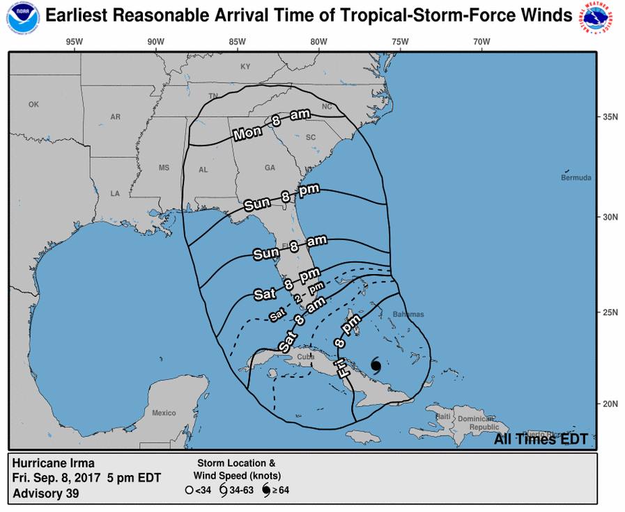
Florida is expected to start feeling tropical storm force winds by Saturday morning, with the hurricane making landfall sometime on Sunday. Meanwhile, the southernmost part of Georgia can expect to start feeling tropical storm force winds by Sunday evening, according to the National Hurricane Center:
National Hurricane Center
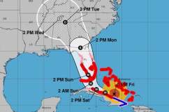
According to this map from the National Hurricane Center, Georgia is the “cone of probability” for the center of the storm, and may see the hurricane’s arrival by around 2 p.m. on Monday, although at that point the storm will be downgraded but still dangerous:
NWSHurricane Irma on Friday September 8 at 5 p.m.
According to Jonathan Belles, a meteorologist with FSU Weather, even when downgraded, Irma poses a risk. He suggested to those evacuating from the Carolinas: “It is a bad idea to evacuate from the Carolinas to Georgia because you could be putting yourself in the way of Hurricane Irma…the whole point of evacuation is to get out of the hurricane, not into it.”
Georgia, he said, could see 3 to 10 inches of rainfall and could be at risk of inland flooding in some areas. “The most likely location to flood is the closest to the track of Irma. Most worried about freshwater/rainfall flooding south of I-4 and in northeast Florida.”
According to Weather.com, strong wind gusts capable of downing trees and power lines could affect south, central, and north Georgia on Monday into early Tuesday. Dangerous storm surges, potentially higher than Matthew, could affect the Georgia coast. And heavy rains could cause inland flooding and worsen coastal flooding.
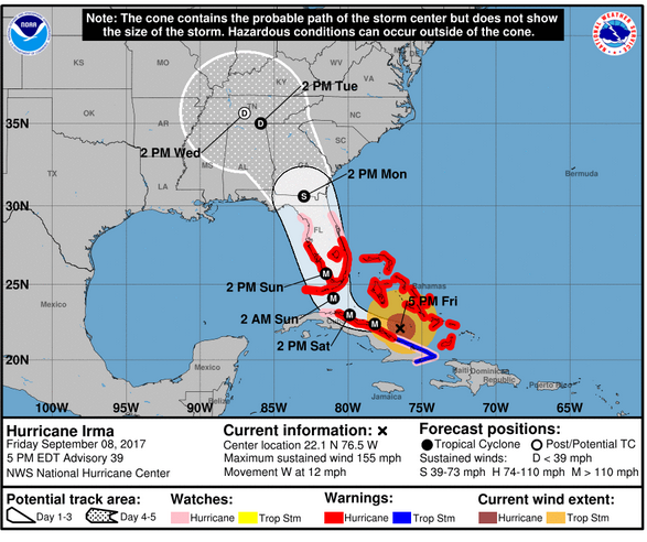
Georgia could start feeling tropical storm winds Sunday evening in the southeast (39 to 73 mph.) The worst weather, in terms of storm surges, hurricane force and tropical force winds, and flooding rain, will likely be Sunday night through Monday in southeast Georgia. At this time, it looks like the center of Irma will track through Georgia.