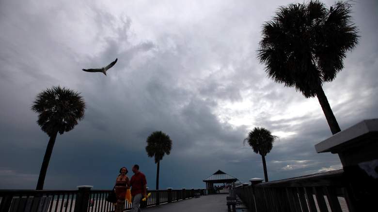
Getty Visitors walk along the Clearwater Pier as storms build offshore on August 25, 2012 in Clearwater, Florida.
As Hurricane Irma slowly makes its way through the Atlantic Ocean and closer to Florida, residents in The Sunshine State are taking proper precautions.
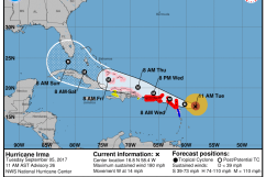
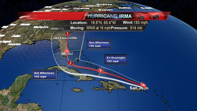
Irma, a Category 5 storm, is currently in the Caribbean with winds topping out at 185 mph. It’s expected to die down prior to making landfall, but meteorologists still project at least a Category 4. Early projections say that the storm will make landfall in the Miami area some time Sunday morning or afternoon. The exact path hasn’t yet been determined, as it’s nearly impossible to do so, though it will become more clear as the weekend approaches. Here’s a look at the current track Irma is projected to take as of September 6:
⚠️ HURRICANE IRMA TRACK: Irma has the potential to make landfall in south Florida as a category 4 hurricane Sunday. #Hurricane #Irma #FLwx
The main brunt of the storm is expected to be felt starting in southern Florida and carry along the east side of the state. While Clearwater is on the western side of Florida, it’s still expected to feel the effects of the massive storm.
On Monday, Florida Governor Rick Scott declared a state of emergency so that “local governments have ample time, resources and flexibility to get prepared for this dangerous storm.”
“In Florida, we always prepare for the worst and hope for the best and while the exact path of Irma is not absolutely known at this time, we cannot afford to not be prepared,” Scott said in a statement.
Gov. Scott Declares State of Emergency to Prepare Florida for Hurricane Irma t.co/tzao5UWxKg
Officials in Clearwater say they are continuing to monitor the track of Irma, and are advising residents in the city to take a look and finalize their hurricane preparedness plans. To see a full checklist to ensure you’re prepared for Irma, click here.
Sandbags are being distributed to those residing in Pinellas County at the following three locations and are limited to 20 per person:
– John Chesnut Sr. Park, 2200 East Lake Road in Palm Harbor
– Lealman Community Park, 3890 55th Ave. N. in St. Petersburg
– Taylor Park, 1100 Eighth Ave. S.W. in Largo
Here’s the current detailed weather forecast for Clearwater through the weekend, according to AccuWeather:
Friday: High of 91 degrees, partly sunny with a shower or thunderstorm during the afternoon. Winds at 8 mph NE.
Friday night: High of 78 degrees, mostly cloudy with winds at 8 mph NE.
Saturday: High of 90 degrees, mostly cloudy and breezy with an afternoon shower or thunderstorm. Winds at 14 mph NE.
Saturday night: High of 79 degrees, low clouds and windy at 28 mph NNE.
Sunday: High of 87 degrees, heavy rain and strong winds from Irma. Heavy tropical rainfall will lead to flooding. Winds at 43 mph NNE with gusts reaching 68 mph.
Sunday night: High of 75 degrees, heavy rain and strong winds from Irma. Winds at 40 mph N with gusts reaching 92 mph.
Monday: High of 82 degrees, some wind and rain from IRma. Winds at 29 mph NW with gusts reaching 54 mph.
Monday night: High of 76 degrees, mostly cloudy with a few showers. Winds at 7 mph WNW with gusts reaching 23 mph.
While Clearwater hasn’t been ordered to evacuate yet, Pinellas County has a website set up and is encouraging its residents to know their evacuation zone. Click here to access the website.