Getty
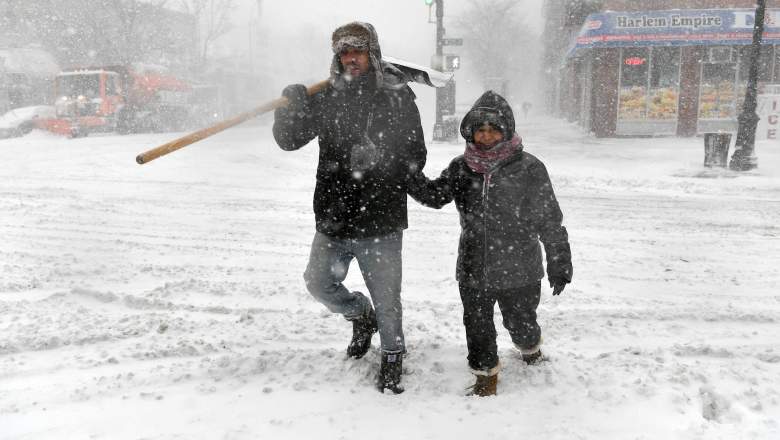
As Winter Storm Quinn nears, travel bans are slowly being put into place for the regions most likely to be affected by the storm. This second nor’easter in a week could bring up to 18 inches of snow to some regions, possibly affecting residents in New York, Boston, Philadelphia, and more. A winter storm warning has been issued across most of the New England area from late tonight through Thursday morning. Areas that may see heavy snowfall include Baltimore, Philadelphia, New York City, and Boston, USA Today reported. Vermont, New Hampshire, and Maine may see up to 18 inches of snow. As the day progressed, some snow predictions were downgraded. Here are more specific details about snowfall predictions for tonight and tomorrow. However, keep an eye on the latest updates. This storm has been difficult to predict.
Boston Snowfall Predictions
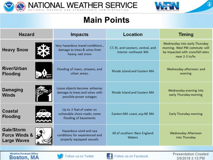
[SUMMARY] A potent Nor’Easter on tap Wednesday into early Thursday, impacting an already vulnerable S New England; threats of heavy snow, damaging winds, coastal flooding; assoc impacts of downed limbs, power outages, reduced visibility, coastal inundation & beach erosion


Predictions for Boston and all of Massachusetts haven’t been consistent. Some sources are saying up to seven inches in Boston and others are saying up to two feet outside Boston, Patch.com reported. Still others are predicting little to no snow.
According to the National Weather Service as of 8:30 p.m. Eastern, little to no snow was expected in Boston tonight. Accumulations of less than one inch are possible on Wednesday, with rain before 4 p.m. and snow after 4 p.m. Another inch is possible Wednesday night. As of 3:15 p.m Eastern, NWS was predicting that the heaviest areas of snow might be seen in the interior northeast of Massachusetts on Wednesday into early Thursday morning, with snowfall rates of two to three inches an hour during the Wednesday evening commute.
New York City Snowfall Predictions
Here is a short video detailing the Updated Snowfall Forecast!
Although New York City was originally expecting much higher snowfall totals, those predictions have currently been reduced as of the time of publication. PIX11 reported that the storm was tracking closer to the coast, so New York City might see four to eight inches tomorrow, and Long Island might see one to four inches. Earlier models had predicted six to 12 inches.
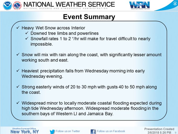
A strong Nor’easter will impact the area Wednesday into Thursday. Threats include: heavy snow, gusty winds, and coastal flooding. For the full briefing click the link: t.co/tLXQHvkzuz


As of 3:42 p.m. Eastern, the NWS was predicting possibly four to eight inches of heavy snow in New Jersey, southern Connecticut, and southeast New York, from midnight through 4 a.m. Thursday. The predictions for New York City by the NWS included four to six inches on Wednesday, with about an inch on Tuesday night.
Philadelphia Snowfall Predictions
The National Weather Service’s current predictions for Philadelphia, as of 8:30 p.m. Eastern, are snow starting around midnight with less than one inch accumulation tonight. About three to five inches of snow and sleet accumulation are possible on Wednesday. However, this can change depending on where the storm tracks tonight.
New Jersey Snowfall Predictions
A strong Nor’easter will impact the area Wednesday into Thursday. Threats include: heavy snow, gusty winds, and coastal flooding. For the full briefing click the link: t.co/tLXQHvkzuz
New Jersey might see accumulations of 10 to 14 inches in the northern parts of the state, and six to 10 inches between Routes 78 and 195, NJ1015.com reported. The state may also see three to six inches below Route 195. Areas near the shore will see more rain and maybe up to three inches of snow, NJ1015.com reported. Other sources have predicted as high as 18 inches of wet, heavy snow in the northern parts of New Jersey.
However, as of 3:42 p.m. Eastern, the NWS was predicting possibly four to eight inches of heavy snow in New Jersey, southern Connecticut, and southeast New York, from midnight through 4 a.m. Thursday. As you can see, the predictions are changing practically from hour to hour, so stay tuned to your local weather service for the latest predictions.