Cal Fire & Google California Fires update
A number of fires are growing in the state of California. While the Beverly Hills fire is more contained now than it was last night, that fire and others still pose a potential threat. Here is a list, with maps, of the larger fires that are around the state, their current containment levels, and where they are located. Read on for more details
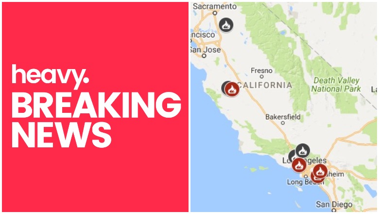
General Maps of California Fires
The first map is an interactive map of some of the bigger fires in California right now, provided by CAL FIRE and Google. Fires in red are active and fires in black are contained.
The map above lists six active fires, which this article will describe in more detail in the next section. They include the Grape Fire, the Chrome Fire, the Beaver Fire, the Portola Fire in Beverly Hills, the Euclid Fire, and the Santiago Fire.
List of Active Fires in California as of June 13
Here is a list of the biggest active fires in California as of June 13.
Grape Fire
This 244-acre fire is 60 percent contained. It began on April 24 and the cause is unknown. It’s located 10 miles northwest of Hyampom and is currently in patrol status. The fire is at Black Bennet Road near Grape Creek, eight miles southwest of Burnt Ranch in Humboldt County.
Chrome Fire
#ChromeFire [update] off Hwy 162 and Forest Hwy 7, north of Elk Creek (Glenn County) is now 2,290 acres and 80% contained. t.co/R8qe1aJiQA
The Chrome Fire, located off Highway 162 and Forest Highway 7 north of Elk Creek in Glenn County is 80 percent contained and 2,290 acres, per Cal Fire.
Beaver Fire
#BeaverFire [Update] E of Bitterwater (San Benito Co.) is now 40%contained at 215 acres. Decrease in acres from earlier post due to more accurate mapping available.
The Beaver Fire in San Benito County is 215 acres and 40 percent contained. It’s located near Coalinga Highway and Airline Highway east of King City. Forward spread has been stopped, according to CAL FIRE.
Euclid Fire / Chino Fire
Helitanker 25Mike making a drop on the #EuclidFire yesterday afternoon in #chino The fire has been contained at approximately 120 acres. @calfirerru #rvcfire #riversidecounty #riversidecountyfiredepartment
#riversidecountyfire #rivcofd #firedepartment #… t.co/Qkg4Z7ZmUo

The Euclid Fire in Chino (Riverside County) is 120 acres and 15 percent contained at this time. It is a wildland fire located at Highway 71 south of Euclid Avenue. There are currently no structure threats or evacuations as of the time of publication. Forward spread of the fire has stopped. About 600 firefighters are responding, along with two helicopters and eight fire crews. Northbound Highway 71 was reopened.
Santiago Fire
Santiago Fire – As of 7:30 am today, the fire will remain at 155 acres (no new growth) & containment has increased to 80%. FFs continue to overhaul the fire & extinguish hot spots. There are still 286 personnel assigned to the fire working toward 100% containment.
The Santiago fire is 155 acres and 80 percent contained, with the forward spread stopped. It’s off Highway 241 and Santiago Canyon Road in Orange County, per Cal Fire.
Portola Fire in Beverly Hills
Overnight your @LAFD used our #UAS technology to map the perimeter of the #PortolaFire & check for hotspots. Our drones are becoming a crucial tool in the fight against wildfire.
The Portola Fire is off Westwanda Drive and Benedict Canyon Drive. This fire remains at about 35 to 40 acres in size and is now at 40 percent containment, so progress has been made since Tuesday night. Evacuations were lifted on Tuesday night, but the affected streets are open only to residents. The following streets are open to residents only: Mulholland Dr from Beverly Glen to Deep Canyon Dr; Benedict Canyon Drive from Mulholland Dr down to the Beverly Hills border. (Note: as of Wednesday morning, Mulholland Drive between Beverly Glen and Deep Canyon was closed to all traffic due to command post activity.)
The brush fire in Beverly Hills was originally reported at 1:57 p.m. on Tuesday in the 9800 block of West Portola Drive in the Beverly Crest area. Although the fire was smaller in size, its location prompted the evacuation of nearby homes. The fire was threatening homes in Portola and Yoakum Drive, NBC reported, and was burning uphill toward Benedict Canyon Drive. An evacuation center was set up at Westwood Recreation Center.
This fire is also being referred to as the Benedict Canyon fire. To stay updated on evacuations for this fire, follow @ReadyLA or @LAFD.
Firefighters said that a weed whacker likely started the fire. It was used by a contractor in the backyard of a residence in the 9800 block of Portola Drive and likely started the flames, officials said. Two firefighters may have been injured.
Additional Fires
It looks like the Coronado Fire from yesterday may be mostly contained, as we can’t find many updates on the Santa Paula fire.
The DeLuz Fire in San Diego is also 75 percent contained.
#DeLuzFire [update] The fire is currently 75% contained. 30 firefighters will be assigned to the fire in order to complete containment and control of the fire.

According to the California Fire Map, the following fires are now contained:
- South Fire: An LA county fire that grew to 175 acres off I-5 and Calgrove Blvd. in Santa Clarita.
- Apple Fire: Now 100 percent contained, this was in Tehama County and grew to 2,956 acres.
- Eastern Fire: This fire in San Benito County grew to 513 acres and is now 100 percent contained.
- Airline Fire: This fire in San Benito County grew to 1,314 acres and is now 100 percent contained.
- Stone Fire: This fire in Los Angeles County grew to 1,352 acres and is now 100 percent contained.
- Liberty Fire: This fire was quickly put out at 62 acres in size in San Joaquin County.
To stay updated on current fire statuses, follow @Cal_Fire.
This is a developing story.