
Inciweb Nevada & Washington Fires
Here are the latest updates about fires in Oregon and Washington as of the August 1. You can see an interactive map of the Oregon and Washington fires here, provided by Oregon.gov, or view an interactive map from NIFC.gov here. Another interactive map is here. Read on for details about active fires in Oregon and Washington as of August 1 according to NIFC.gov and other sources.
See an interactive fire map of the two states below:
Here are details on the individual fires.
116 Wilson Prairie Fire
This Oregon fire is 405 acres, 93 percent contained, 30 miles south of Heppner near Bull Prairie Reservoir. This fire was caused by human activity.
Cemetery Fire
This Oregon fire is 1,414 acres and 97 percent contained. It’s 32 miles southeast of Prineville and Inciweb is no longer updating its page on the fire. It was caused by lightning.
Chelan Hills Fire
7/31 update on #ChelanHillsFire: 97% containment. Two primary residences, one seasonal home and several outbuildings were confirmed as damaged. Some corn and approximately 80 acres of wheat fields were also damaged. #WaWILDFIRE t.co/IdHIr487V8
This Washington Fire is 1,842 acres and 97 percent contained. It’s 2 miles east of Chelan. Two residences, a seasonal home, and some outbuildings were damaged from the fires, along with corn fields and 80 acres of wheat fields.
Cougar Creek Fire
Wildfire Update: #CougarCreekFire now 400ac in extreme terrain. Type 2 Team arriving today. Full details at t.co/e3NgJytn44 #WaWildfire

This Washington fire is 803 acres and 0 percent contained. It’s 8 miles northwest of Manson and 20 miles northwest of Entiat. The smoke from the fire is visible for miles. It was caused by lightning.
As of 3 p.m. Wednesday, Level 1 evacuation notices were raised to Level 2 (which means “get ready to leave”), Wenatchee World reported. These covered Mad River Road to Entiat River Road, milepost 24 on both sides.
Garner Complex Fire
So far, the fires are holding at just under 9,000 acres. #GarnerComplexFire #Oregononfire #Oregonwildfires t.co/jioGmZ1uly
The Oregon fires total about 8,886 acres and 68 percent contained, caused by lightning, according to NIFC. Technically this refers to multiple fires: Wagner Creek is in Jackson County and Garner Complex is in Josephine County.
Goodview Fire
This Oregon fire is 1,630 acres, 0 percent contained, and 10 miles northwest of Prospect.
Hendrix Fire
This Oregon fire is 1,082 acres, 70 percent contained, and 3 to 9 miles southwest of Ashland. The fire was caused by lightning. A community meeting was held tonight at 7 p.m. at Ashland Middle School. The southeast corner of the fire remains uncontained, according to Inciweb, and is being monitored.
According to Inciweb on August 1: “The evacuation level remains at Level 1 for the Jackson County Hendrix Fire evacuation area. Level 1 means “BE READY” for potential evacuation. Residents should be vigilent and monitor emergency services websites and local media outlets for information. For the latest information, go to http://jacksoncountyor.org/sheriff/. Residents in the area are encouraged to sign up for Citizen Alert at http://www.jacksoncounty.org/alert. More information about evacuation levels and preparedness can be found at http://www.rvem.org.”
Klondike Fire
The Southwest Oregon Joint Information Center has released a new update for August 1, 2018. To read the complete update, visit t.co/xEvl7YLYul
#GarnerComplex #SugarPineFire #KlondikeFire #NatchezFire #SouthUmpquaFire #TimberCrater6Fire

This Oregon fire is 19,530 acres, 5 percent contained and 9 miles northwest of Selma. There is a chance that this fire and the Taylor Creek fire might meet, as they grew to be within 3 miles of each other on Tuesday.
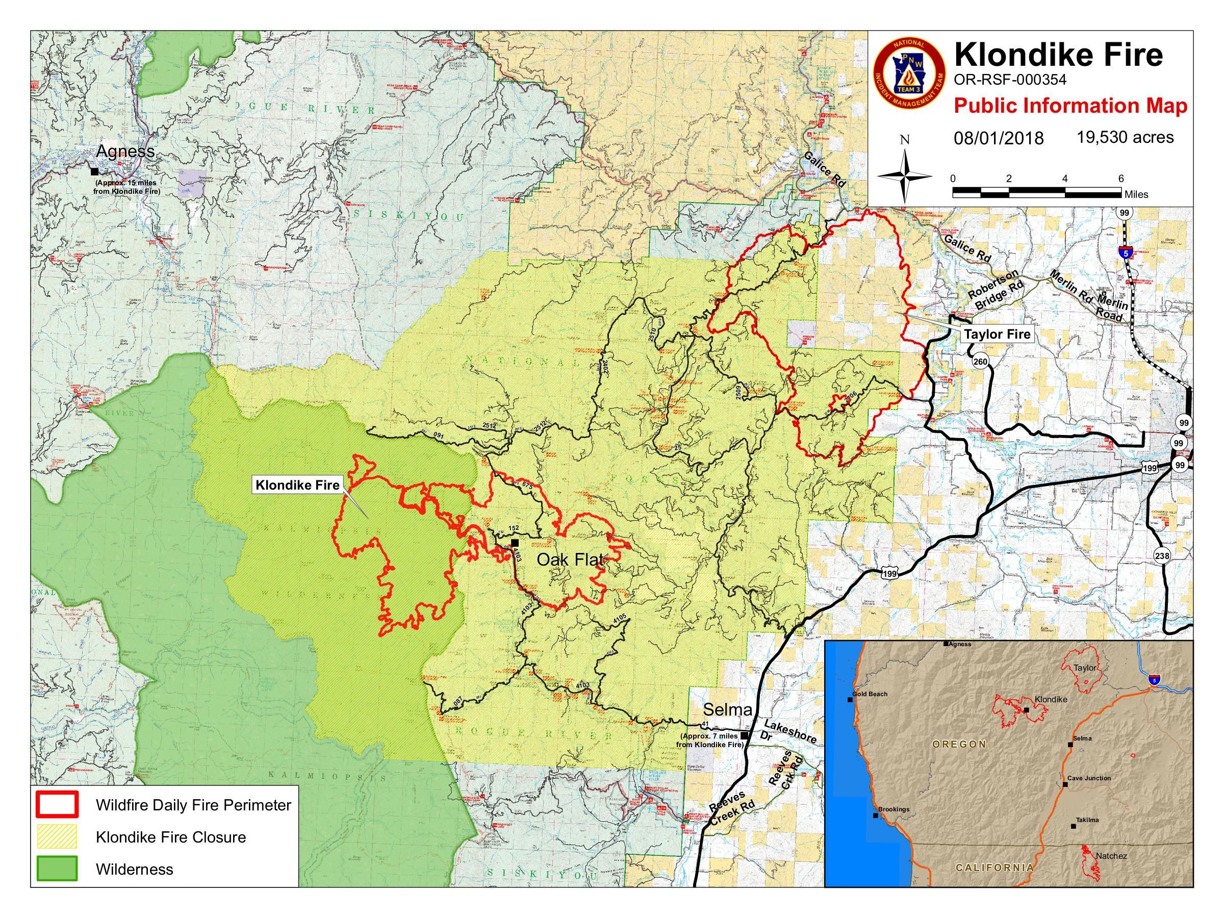
Klondike fire map
According to Inciweb: “Evacuations: A level 3 “Go” evacuation remains in effect for Oak Flat at the end of the Illinois River Road in Josephine County. Illinois River Road from mile post 2.5 to Oak Flat is at a Level 2 “Get Ready.” Visit Josephine County Emergency Management on Facebook for current information.”
Lake Wallula Fire
This Washington Fire is 12,462 acres and 96 percent contained. It’s 5 miles east of Umatilla and on July 30 spread from Oregon into Washington.
Long Hollow Fire
#LongHollowFire containment now at 95%! NWIMT #10 is transitioning the fire to the local unit. For additional information on this fire and for more information on wildfires in central Oregon, visit t.co/dqNYXPJelI or call 541-316-7711.

This Oregon fire is 33,451 acres, 95 percent contained, and 5 miles south of Dufur. Here is a map of the fire when it was at 75 percent containment:
#LongHollowFire update: 33,451 acres, 75% contained. 218 personnel. Expected to stay within lines but red flag & excessive heat warnings in effect with high fire behavior potential.

It was caused by human activity.
Natchez Fire
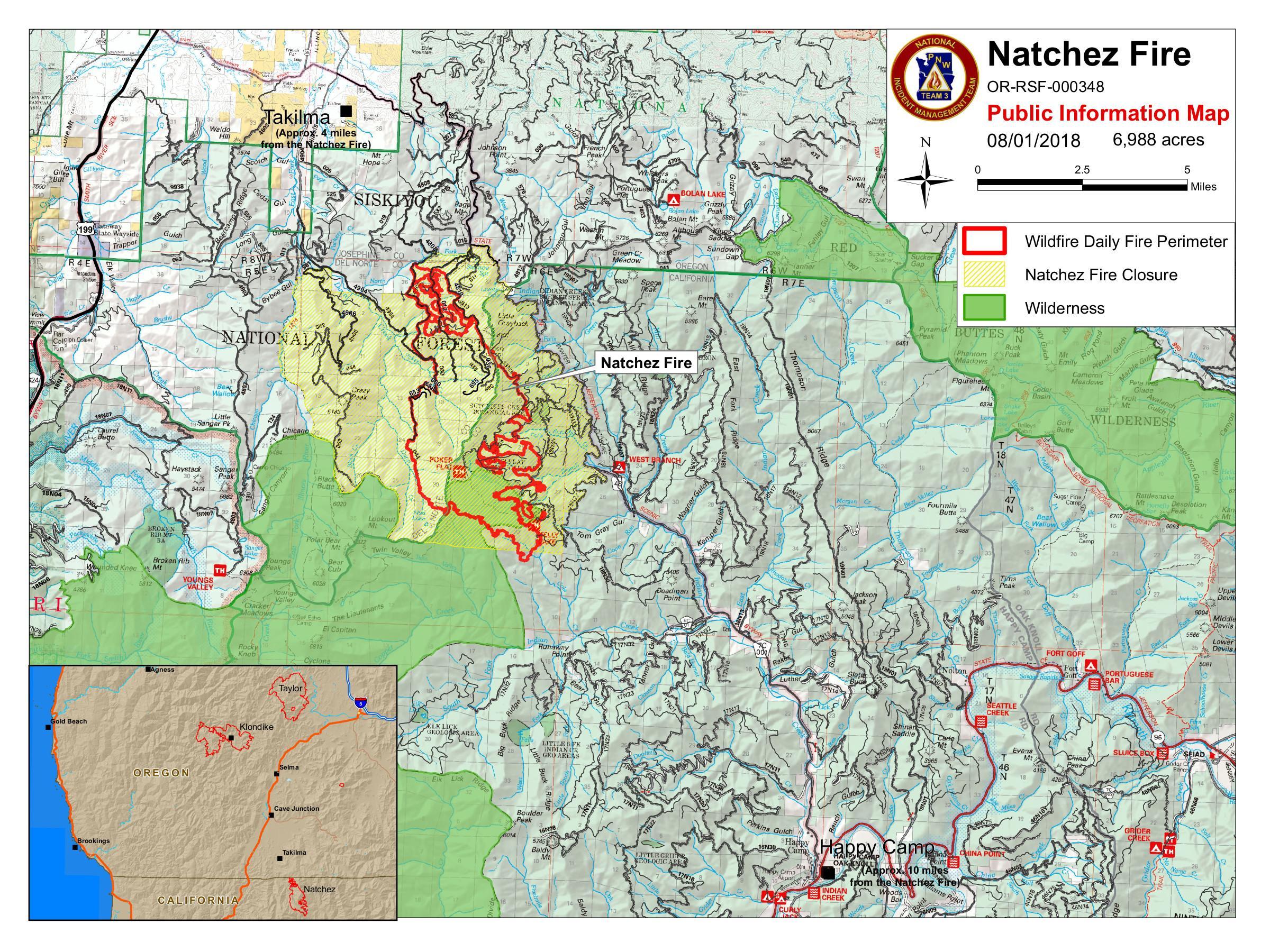
InciwebNatchez Fire Map
This Oregon fire falls under the jurisdiction of the Oregon Department of Forestry Fire, but is listed on the CAL FIRE map. It’s 6,988 acres and 15 percent contained. It was caused by lightning. It’s located 15 miles southeast of Cave Junction, Oregon, located on the Oregon/California border between Happy Camp, California and Cave Junction, Oregon. Some active surface spread is still expected.
According to Inciweb on August 1: “The community of Sunstar has been placed in a Level 1 evacuation “Ready” status. Del Norte County, CA, including the community of Sunstar, has adopted the Oregon three level evacuation process. For Del Norte County emergency notification information, visit: http://www.co.del-norte.ca.us/departments/administration/emergency-services.In Siskiyou County, there are two levels to the evacuation process, Evacuation Warning, and Evacuation Order. A warning means be ready to evacuate, and an order means evacuate now.”
And: “Effective 2:30pm August 1, Siskiyou County Sheriff’s Office has issued an evacuation order for the two residences near the terminus of the South Fork Road (National Forest System Road 17 N 32). The residents received a warning on July 31 and chose to evacuate. Siskiyou County Sheriff’s Office has also issued an evacuation warning for all residences accessed by the South Fork Road (Road 17N32) and all residences accessed by the Grayback road north of the junction of the South Fork Road (Road 17 N 32) and the Grayback Road. This warning is being issued as a precautionary measure, the fire is still within the containment lines, but is progressing within close proximity to these residences.”
Pole Creek Fire
This Oregon fire is 821 acres, 75 percent contained, and 20 miles south of Jordan Valley.
Round Top Fire
This Oregon fire is 156 acres, 48 percent contained, and 8 miles northwest of Prospect.
Sheep Creek Fire
Air resources continue to assist the #SheepCreekFire

This Washington fire is 146 acres and 0 percent contained. It’s 4 miles northwest of Northport. On August 1, the fire’s biggest threat was along the east flank. The fire’s cause is under investigation. According to the Northeast Washington Interagency Communications Center: “Sheep Creek campground, and the cabins in the Sheep Creek area, are still evacuated. The entrance of Sheep Creek Road has been blocked off by the local Sheriff’s department.”
For updated details on evacuations, call 509-684-2555.
South Umpqua Complex Fire
This Oregon fire is 16,428 acres and 16 percent contained. It’s 30 miles southeast of Myrtle Creek and consists of three larger fires. According to NIFC: “The Umpqua National Forest has issued an Emergency Fire Closure for several trails and roads on the Forest. In an effort to strengthen defenses along the upper flank of the Miles Fire, two hotshot crews spent the night burning out fuels between the established line and the approaching fire. Progress was made, but limited by higher night-time relative humidity which kept the fine fuels from carrying the fire.”
According to Inciweb on August 1: “Based on the recommendation of fire officials managing the Sugar Pine Fire, the Jackson County Sheriff’s Office has increased the evacuation advisory for residences in the Elk Creek Road area from Level 2 “Be Set” to Level 3 “Go.” A Level 3 “Go” advisory is now in effect for the following addresses: 8800 to 17600 Elk Creek Road; Sugar Pine Road, all addresses; Dodes Creek road, all addresses. The Miles Fire spotted ahead and was moving down Flat Creek causing fire officials to recommend the Level 3 evacuation.For more information call (541) 474-5305 or visit https://inciweb.nwcg.gov/incident/5966/.”
Substation Fire
This Oregon fire is 78,425 acres, 97 percent contained, and 5 miles south of The Dalles.
Sugar Pine Fire
#UPDATE: The PIO Trainee deployed to OR on July 23, 2018, sent photos from the 19 wildfires managed under the collective name Sugar Pine, which have now burned over 6,000 acres: t.co/hVd7LXjZui
#Wildfire #Mississippi #Oregon #PeopleofForestry #ORFire #SugarPineFire


This Oregon fire is 4,171 acres, 0 percent contained, and 12 miles northwest of Prospect. (Inciweb from July 31 records it as 6,086 acres.) This is a collective name for multiple fires. Keep updated on Facebook here.
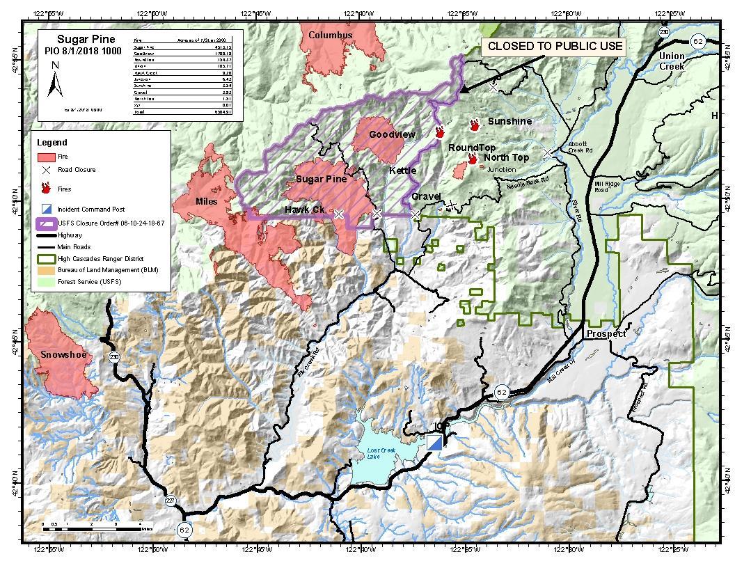
InciwebSugar Pine Fire Map
It was caused by lighting.
Taylor Creek Fire
Latest #TaylorCreekFire map. It’s about a half-mile from Galice Road between Indian Mary and Taylor Creek Road.
Story: t.co/P7yP9y94WG

It’s 29,551 acres in size and 30 percent contained as of August 1. You can find the latest evacuation updates on the Josephine County Emergency Management Facebook page. If you have not signed up for Josephine County Citizen’s Alert, Josephine County’s emergency notification system, you can sign up on line at www.rvem.org. It’s an Oregon fire, but is included on CAL FIRE’s listing.
Map of current evacuations for the #TaylorCreekFire

The Red Cross evacuation shelter remains active at Grants Pass High School (830 NE 9th St, Grants Pass, OR 97526).
The Fire Information Center can be reached at 541-474-5305 and is staffed from 8:00am to 8:00pm each day.
An animal evacuation center is open at the Josephine County Fairgrounds Floral Building located at 1451 Fairgrounds Road, Grants Pass, OR.
Timber Crater Fire
This Oregon fire is 3,126 acres, 85 percent contained, and 20 miles southwest of Chemult.
Timber Crater 10 Fire
This Oregon fire is 193 acres, 60 percent contained, and 20 miles southwest of Chemult.
Union Fire
This Oregon fire is 106 acres, 68 percent contained, and 10 miles northeast of Prospect.
Warner Gulch Fire
This Washington fire is 470 acres and 85 percent contained. It’s 11 miles southwest of Asotin.