
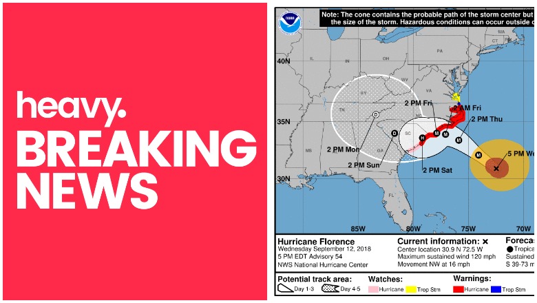
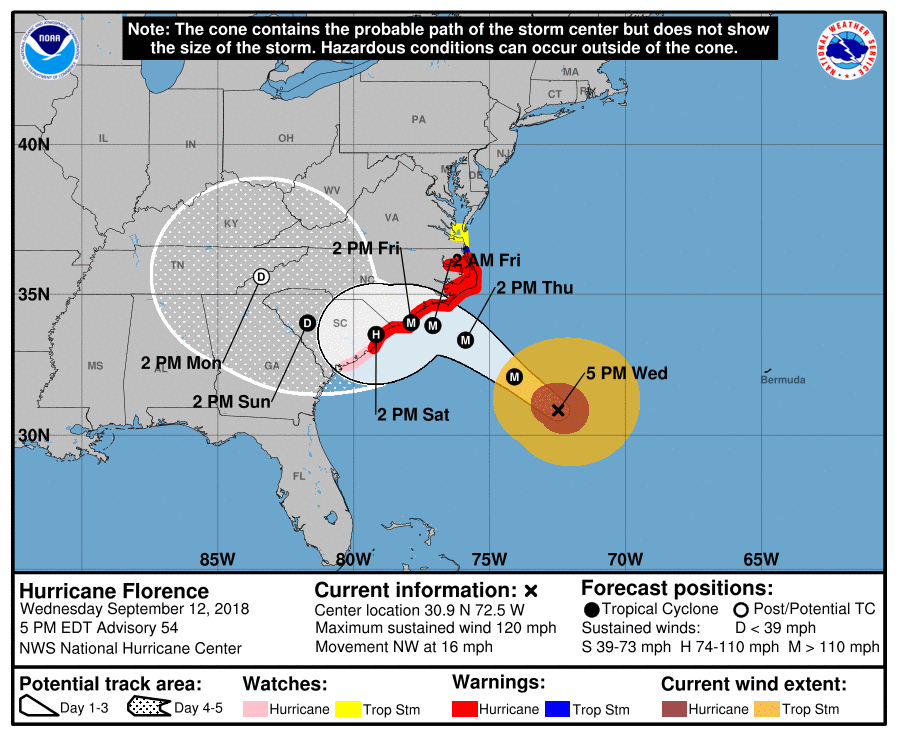
Hurricane Florence is nearing the southeast U.S. coast, and the National Hurricane Center is providing frequent updates about the storm’s movements. Here are details from the latest update from the NOAA as of Wednesday, September 12, at 5 p.m. Eastern (4 p.m. Central.) The next update will be at 11 p.m. Eastern, and an intermediate update will be at 8 p.m. Eastern. You can read the full updates on the NOAA’s website here.
Hurricane Florence’s Location, Coordinates & Movement
NOAA
As of 5 p.m., Florence was located at 30.9 N, 72.5 W. It is about 385 miles (615 km) southeast of Wilmington, North Carolina, and about 420 miles (675 km) ESE of Myrtle Beach, South Carolina.
It’s moving NW or 315 degrees at 16 mph (26 km/h.)
The National Hurricane Center noted the following at 5 p.m.: “Florence ismoving toward the northwest near 16 mph (26 km/h), and this general motion, accompanied by a gradual decrease in forward speed, is expected to continue through Saturday. On the forecast track, the center of Florence will move over the southwestern Atlantic Ocean between Bermuda and the Bahamas tonight, and approach the coast of North Carolina or South Carolina in the hurricane warning area on Thursday and Friday, and move slowly near the coastline through Saturday.”
Hurricane Florence’s Wind Strength, Pressure, & Rainfall
The storm’s maximum sustained winds as of 5 p.m. are 120 mph, NOAA noted. This means the storm has weakened slightly and is now a Category 3 instead of a Category 4. NOAA notes: “Some fluctuations in strength will be possible through Thursday morning. Although slow weakening is expected to begin by late Thursday, Florence is forecast to be an extremely dangerous major hurricane when it nears the U.S. coast late Thursday and Friday.”
In other words, even though the storm has weakened, that’s no reason to stop being cautious. A Category 3 storm is still very dangerous, and the storm might strengthen again before making landfall.
The storm’s minimum central pressure is 949 MB or 28.03 inches.
Hurricane-force winds extend outward up to 70 miles from the center, and tropical storm force winds extend outward up to 915 miles from the center. Hurricane-force winds may reach the coast within the warning area by late Thursday or Friday. Tropical storm strength winds will be felt on Thursday.
Florence is expected to produce heavy and excessive rainfall, NOAA noted. In coastal North Carolina, this could be 20 to 30 inches, isolated up to 40 inches in some areas, which could lead to catastrophic flooding.
In South Carolina, western, and northern Carolina, rain could be 5 to 10 inches, isolated up to 20 inches. In the Appalachians and mid-Atlantic states, this could be 3 to 6 inches, isolated up to 12 inches.
Current Watches & Warnings
According to the National Hurricane Center, the following warnings and watches are in effect.
Hurricane Warning
- South Santee River, South Carolina to Duck, North Carolina
- Albermarle and Pamlico Sounds
According to NHC: “A Hurricane Warning means that hurricane conditions are expected somewhere within the warning area. A warning is typically issued 36 hours before the anticipated first occurrence of tropical-storm-force winds, conditions that make outside preparations difficult or dangerous. Preparations to protect life and property should be rushed to completion.”
Hurricane Watch
- Edisto Beach, South Carolina to South Santee River, South Carolina
According to NHC: “A Hurricane Watch means that hurricane conditions are possible within the watch area. A watch is typically issued 48 hours before the anticipated first occurrence of tropical-storm-force winds, conditions that make outside preparations difficult or dangerous.”
Tropical Storm Warning
- North of Duck, North Carolina to the North Carolina/Virginia border
Tropical Storm Watch
- North of the North Carolina/Virginia border to Cape Charles Light, Virginia
- Chesapeake Bay south of New Point Comfort
According to NHC: “A Tropical Storm Watch means that tropical storm conditions are possible within the watch area, generally within 48 hours.”
Storm Surge Warning
- South Santee River, South Carolina to Duck, North Carolina
- Albemarle and Pamlico Sounds, including the Neuse and Pamlico
Rivers
According to NHC: “A Storm Surge Warning means there is a danger of life-threatening inundation, from rising water moving inland from the coastline, during the next 36 hours in the indicated locations. For a depiction of areas at risk, please see the National Weather
Service Storm Surge Watch/Warning Graphic, available at hurricanes.gov. This is a life-threatening situation. Persons located within these areas should take all necessary actions to protect life and property from rising water and the potential for other dangerous conditions. Promptly follow evacuation and other instructions from local officials.”
Storm Surge Watch
- Edisto Beach, South Carolina to South Santee River, SC
- North of Duck, North Carolina, to the North Carolina/Virginia border
According to NHC: “A Storm Surge Watch means there is a possibility of life-threatening inundation, from rising water moving inland from the coastline, in the indicated locations during the next 48 hours.”
Additional watches and warnings may be issued, so stay tuned.
Additional Hurricane Discussions
The NOAA’s 5 p.m. update included some additional information worth noting.
“Data from an Air Force Reserve hurricane hunter aircraft along with satellite imagery and various intensity estimates indicate that Florence has weakened instead of strengthening. However, while the hurricane hasn’t strengthened in terms of peak winds, the inner-core and outer wind fields have continued to expand, resulting in an increase the cyclone’s total energy, which will create a significant storm surge event. The upper-level outflow remains impressive and is still expanding except toward the south.”
READ NEXT: Live radars to track Hurricane Florence