
New Bern, NC is already seeing significant flooding from Hurricane Florence, as maps, videos and other reports from the community of 30,000 people show. You can follow New Bern’s flooding conditions on an ArcGIS map put out by the city.
The governor of North Carolina said that more than 100 people had been rescued from New Bern. Later, local news media station Newson6 reported that between 150-200 people were rescued in New Bern and about 100 more still needed rescuing.
Water levels reached 10 feet, and some water rescues were already being reported in the first minutes of September 14, 2018.
The roof was blown off a store in New Bern on the evening of September 13, 2018.
Dramatic videos surfaced. The City of New Bern wrote on Twitter, “Currently ~150 awaiting rescue in New Bern. We have 2 out-of-state FEMA teams here for swift water rescue. More are on the way to help us. WE ARE COMING TO GET YOU. You may need to move up to the second story, or to your attic, but WE ARE COMING TO GET YOU. #FlorenceNC.”
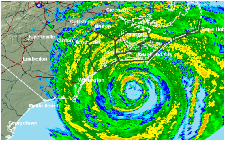
Flooding from the Neuse and Trent Rivers was compounding the problems in New Bern, combining with rainfall to flood roadways.
Things got so bad so fast that the CNN reporter assigned to New Bern left the area. There was already a report on Twitter of a home possibly flooding. “Another relay to #hamradio reports individual in the C Street area of New Bern seeking rescue, report was ‘water is at least waist deep’ in her home. Attempt made to relay to PD, however locals says the 911 call center ‘at wits end’ and only call for immediate life threat,” the report claimed.
Another person wrote on Twitter: “F*CKIN STRESSED OUT MY GRANDMA AND UNCLE JUST BARELY MADE IT OUT THE HOUSE THE WATER WAS COMING UP SO FAST SMH THEY CANT EVEN LEAVE NEW BERN NOW THEY HAD TO GO TO MY AUNT HOUSE AND WHO KNOWS WHEN THE WATER WILL REACH HER HOUSE SMH ?”
Videos also captured some scenes of the flooding. New Bern is a riverfront community near the North Carolina coast that is located in Craven County.
“Told y’all these serious situations are nothing to joke about!! families are stuck with rushing water entering their homes.. nothing but prayers up for my little town of New Bern and everywhere else ??” wrote one woman on Twitter.
Here’s the National Weather Service forecast for New Bern, as of the late evening of September 13, 2018.

NWS
See satellite radar imagery for New Bern here.
New Bern weather is managed out of the Newport/Morehead City, North Carolina office of the National Weather Service. See the hourly forecast for that region here.
Read the full briefing document for the hurricane here.
That office put out a flash flood watch for the area on the evening of September 13, writing, “…EXTREMELY HEAVY RAIN ASSOCIATED WITH HURRICANE FLORENCE WILL LIKELY PRODUCE LIFE THREATENING FLASH FLOODING…Hurricane Florence will impact the area into the weekend, bringing potentially historic rainfall amounts and unprecedented flooding across southern portions of eastern North Carolina.”
How much rain is expected? “Widespread and extremely heavy rain associated with Hurricane Florence will continue into the weekend. Many coastal areas have already received several inches of rainfall. Rainfall totals of around 20 to 30 inches, with isolated amounts up to 40 inches, are possible through Saturday,” NWS wrote.
Potential perils include flash floods, tornados, and storm surges. The evening hazardous weather outlook for the area was as follows on the evening of September 13, 2018:
“Hazardous Weather Outlook
National Weather Service Newport/Morehead City NC
527 PM EDT Thu Sep 13 2018
NCZ029-044>047-080-081-092>094-142130-
Martin-Pitt-Washington-Tyrrell-Mainland Dare-Beaufort-Mainland Hyde-
Jones-Craven-Pamlico-
527 PM EDT Thu Sep 13 2018
…FLASH FLOOD WATCH IN EFFECT THROUGH SATURDAY EVENING…
…TORNADO WATCH 371 IN EFFECT UNTIL 9 PM EDT THIS EVENING…
…HURRICANE WARNING IN EFFECT…
…STORM SURGE WARNING IN EFFECT…
This Hazardous Weather Outlook is for eastern North Carolina.
.DAY ONE…Tonight.
Please listen to NOAA Weather Radio or go to weather.gov on the
Internet for more information about the following hazards.
Tornado Watch.
Flash Flood Watch.
Storm Surge Warning.
Hurricane Warning.
.DAYS TWO THROUGH SEVEN…Friday through Wednesday.
Please listen to NOAA Weather Radio or go to weather.gov on the
Internet for more information about the following hazards.
Flash Flood Watch.
Storm Surge Warning.
Hurricane Warning.”
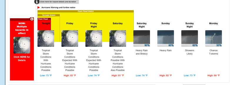
Extended Weather Forecast for New Bern, NC
As of the evening of September 13, 2018, this was the weather forecast for Bern, NC:
Detailed Forecast
“Tonight (September 13, 2018)
Tropical storm conditions, with hurricane conditions possible. Showers and possibly a thunderstorm. Some of the storms could produce heavy rainfall.
Friday
Tropical storm conditions expected, with hurricane conditions possible. Showers and possibly a thunderstorm. Some of the storms could produce heavy rainfall. High near 83. Chance of precipitation is 100%. New rainfall amounts in excess of 4 inches possible.
Friday Night
Tropical storm conditions expected, with hurricane conditions possible. Showers and possibly a thunderstorm. Some of the storms could produce heavy rainfall. Low around 74. Chance of precipitation is 100%. New rainfall amounts between 2 and 3 inches possible.
Saturday
Tropical storm conditions possible, with hurricane conditions also possible. Showers and possibly a thunderstorm. Some of the storms could produce heavy rainfall. High near 81. Chance of precipitation is 100%. New rainfall amounts between 1 and 2 inches possible.
Saturday Night
Showers and possibly a thunderstorm. Some of the storms could produce heavy rainfall. Low around 74. Breezy, with an east wind 13 to 21 mph, with gusts as high as 31 mph. Chance of precipitation is 90%. New rainfall amounts between three quarters and one inch possible.
Sunday
Showers and possibly a thunderstorm. Some of the storms could produce heavy rainfall. High near 82. Chance of precipitation is 80%. New rainfall amounts between a half and three quarters of an inch possible.
Sunday Night
Showers likely and possibly a thunderstorm before 9pm, then a chance of showers. Mostly cloudy, with a low around 73. Chance of precipitation is 60%.
Monday
A chance of showers, with thunderstorms also possible after 9am. Mostly cloudy, with a high near 84. Chance of precipitation is 50%.
Monday Night
A chance of showers and thunderstorms. Mostly cloudy, with a low around 72. Chance of precipitation is 50%.
Tuesday
A chance of showers, with thunderstorms also possible after 9am. Mostly cloudy, with a high near 86. Chance of precipitation is 50%.
Tuesday Night
A chance of showers and thunderstorms. Mostly cloudy, with a low around 73. Chance of precipitation is 50%.
Wednesday
A chance of showers and thunderstorms. Partly sunny, with a high near 87. Chance of precipitation is 40%.
Wednesday Night
A chance of showers and thunderstorms. Partly cloudy, with a low around 71. Chance of precipitation is 40%.
Thursday
A chance of showers and thunderstorms. Mostly sunny, with a high near 86. Chance of precipitation is 40%.”