

Utah is seeing an influx of new fires, some which are prompting evacuations. Here is a list of the major active fires on September 15, according to Utah Fire Info, NIFC.gov, and other sources, along with maps on where the larger ones are located. Read on to learn more details and see maps of the fires in the Utah area.
You can view a map of all the Utah fires here. This map is being constantly updated. You can see a screenshot of Utah Fire Info’s current map below:
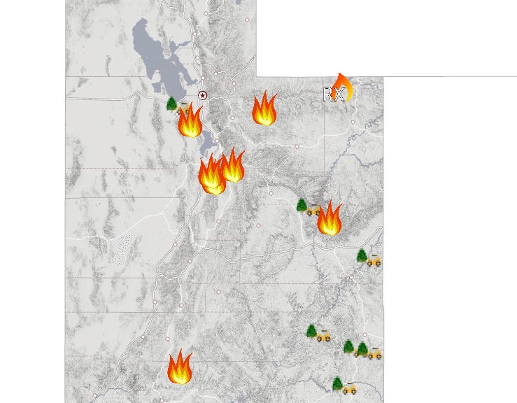
Utah Fire Info
Bald Mountain Fire & Pole Creek Fire
The Bald Mountain fire, in the Uinta-Wasatch-Cache National Fores, is 5,000 acres and 0 percent contained according to NIFC (but Utah Fire Info is now saying the fire is 17,760 acres.) It’s 7 miles northeast of Mona. The fire was caused by lightning.
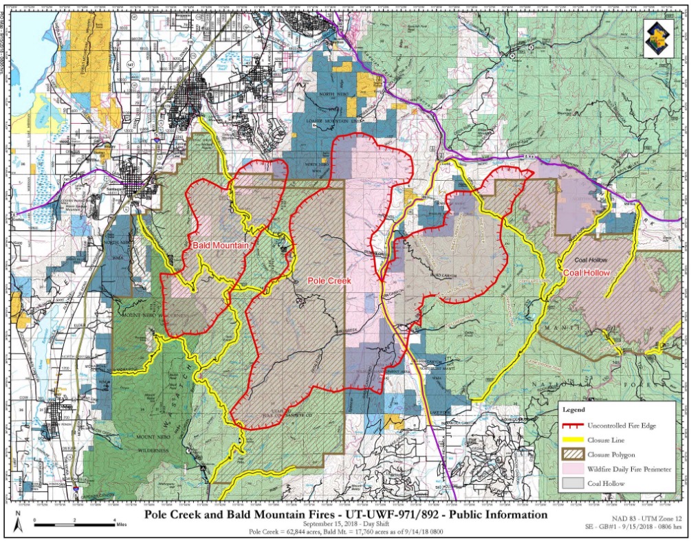
Utah Fire InfoBald Mountain and Pole Creek Fire Map
Meanwhile, the Pole Creek Fire is at 62,844 acres, according to Utah Fire Info. (Inciweb notes the size as 68,347 acres and 2 percent contained.) This fire was caused by lightning. It’s 12 miles NE of Nephi, Utah, off Mount Nebo Loop road.
Many sources are now saying the two fires have merged into one. You can see an interactive map on Google for the two fires, including evacuation details, below:
Jake Jones, who was hunting near Bald Mountain in late August, told KUTV that when he first saw the small fire, it looked like a campfire, but he called the forest service to make sure they were aware of the fire. At the time, he thought a couple people with shovels could have put the fire out.
Evacuation Details: Evacuations have been issued in the area which include more than 5,000 residents in Woodland Hills and Elk Ridge, plus Covered Bridge Canyon and Spanish Fork Canyon, KSL reported.
Pre-evacuation notices have been issued for Diamond Fork Canyon.
An evacuation center is set up at Salem Hills High School at 150 Skyhawk Blvd. in Salem. Self-sufficient campers, trailers, and RVs can also park in the parking lot of the high school, and evacuees will have access to bathrooms 24 hours a day.
Closures include parts of U.S. Highway 6, U.S. Highway 89 (in Spanish Fork Canyon from Thistle Junction to the Utah/Sanpete county line), and the Nebo Loop Rouand and Nephi Canyon Road at the State Route 132 turnoff in Juab County.
An area closure was also implemented for all roads and trails in the fire area, including Santaquin Canyon, Mona Pole Canyon, and the Nebo Loop National Scenic Byway from Payson Canyon to Salt Creek Canyon, Utah Fire Info noted.
Bear Trap Fire
This fire is 12,246 acres and 25 percent contained, according to NIFC. It’s 44 miles southeast of Price. It was caused by lightning. The last update from the BIA Forestry & Wildland Fire – Uintah & Ouray Agency, on September 11, noted that hot and dry weather patterns were causing the Bear Trap fire to show smoke and increased activity, although the acreage itself had not increased. The fire was started by lightning.
The fire is just north of Bear Trap Knoll, and west of Big Springs in Hill Creek. It’s on the Uintah and Ouray Indian Reservation, KUTV reported. Here’s the approximate location of the reservation:
This next map is about a month old but it’s the most recent map we have of the fire. The fire may be about 2,000 acres larger since this map:
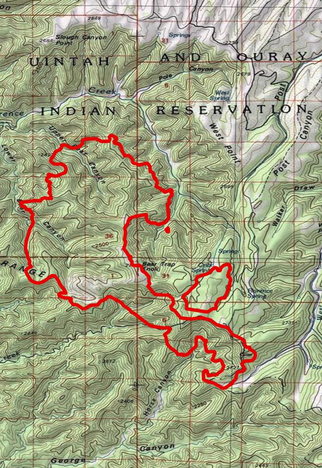
BIA ForestryBear Trap Fire
Bender Mountain Fire
This fire is in the Vernal District and is 4,113 acres and 85 percent contained, according to NIFC. It’s 17 miles northwest of Dutch John. The fire was human caused, but arson was not suspected.
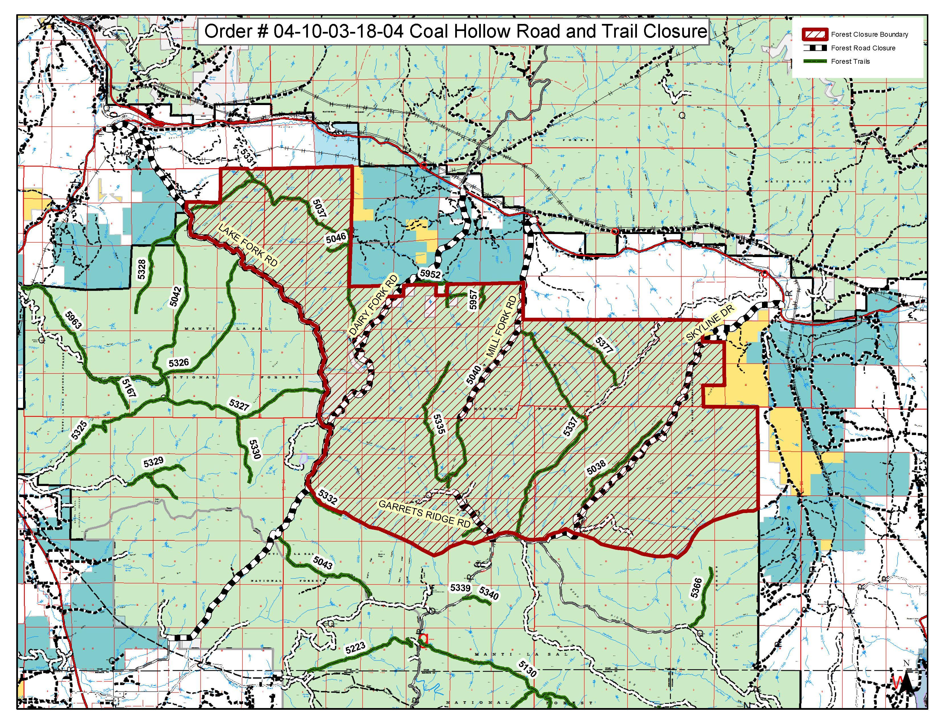
Coal Hollow Fire
This fire is 31,661 acres and 96 percent contained as of September 12. It’s 11 miles northeast of Price and 15 miles southeast of Spanish Fork, Utah. It was caused by lightning. It’s near SR-6 and Dairy Fork. It’s not listed on NIFC’s website but is still listed on Utah Fire Info’s map. The fire was transitioned to a local team on August 30. Fire behavior is minimal. The following is a Coal Hollow Closure map from three days ago:
Inciweb
For updated details on this fire, call 435.427.0846 or 435.427.4849.
D1 Pondo Prescribed Fire
Utah Fire Info’s map lists the D1 Pondo Prescribed Fire, which apparently is scheduled for a burn on October 1 at 1 a.m. It’s 3,000 acres and is projected to end on November 15. It will include 1,400 acres in the Utah Fire Tower area and 800 acres in the Scraper Springs area, and a potential 800 acres north of Long Park Reservoir.
Herriman Fire
This is not on Utah Fire Info’s map or on the NIFC list, but the newer fire (which actually consists of two fires) just started today, September 15. (You can see photos and videos in Heavy’s story here.) The first fire started in Herriman and the second began near I-80. The first fire destroyed three homes.
Evacuation Details: People near the first fire have been asked to leave their homes and evacuate. A mandatory evacuation was issued for Hi County. An evacuation center was being set up at Butterfield Canyon Elementary School at 6860 Mary Leizan Lane in Herriman.
Lonely Fire
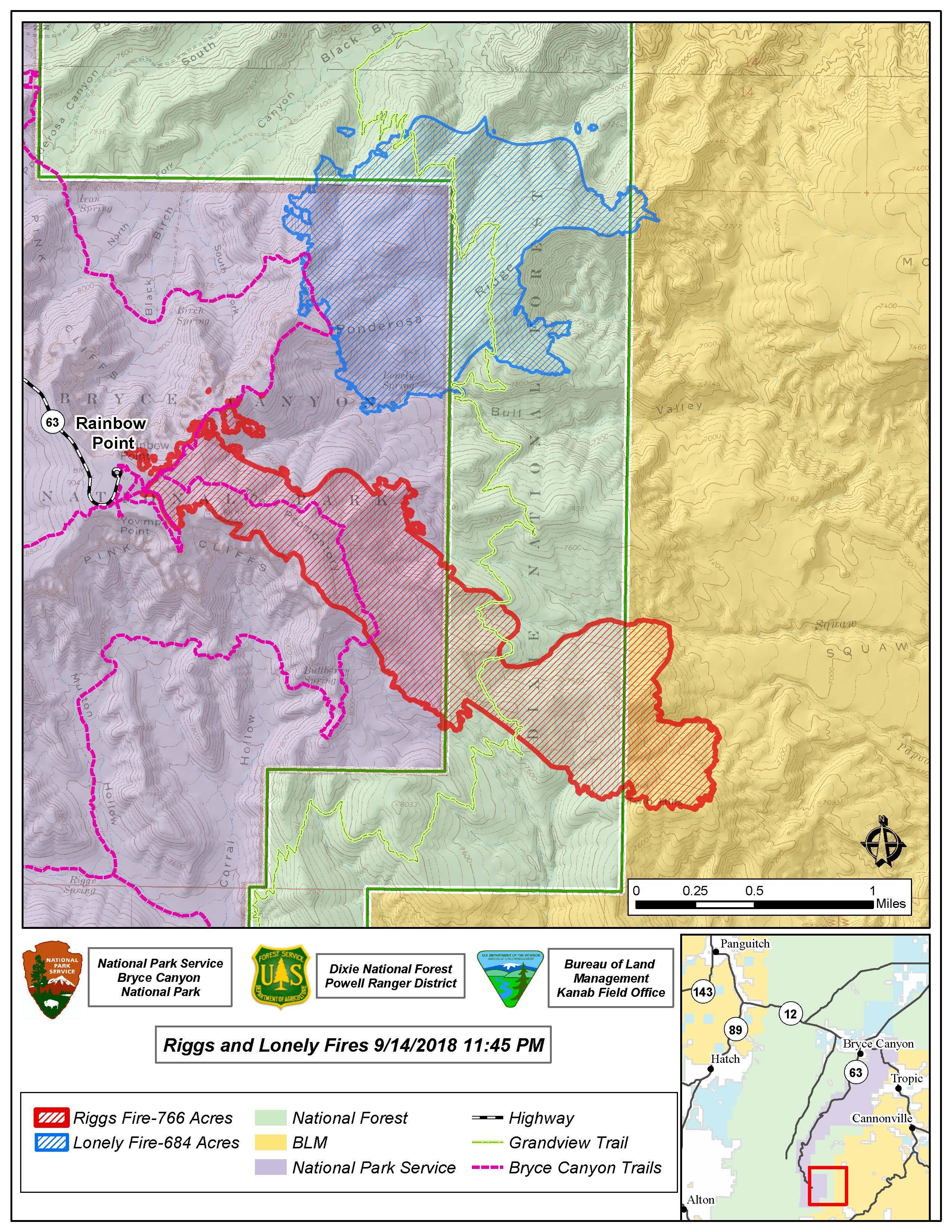
InciwebRiggs and Lonely Fire Map
This fire in Bryce Canyon National Park is 684 acres and 0 percent contained, according to Inciweb. It’s 11 miles southwest of Cannonville. (It may have grown to 554 acres as of September 14, SU Independent reported.)
This fire is listed on Inciweb with the Riggs fire. Inciweb noted: “There are three trail closures currently in place. Within the Dixie National Forest the Grandview Trail (066) from the Willis Creek junction to Lower Podunk. In Bryce Canyon National Park the Riggs Spring Loop Trail is closed, including the connector trail from Riggs Springs to the Grandview Trail. The Under-the-Rim Trail is also closed from Agua Canyon to Rainbow Point. These trails are temporarily closed for the safety and welfare of the public”
Murdock Fire
This fire in Uinta-Wasatch-Cache National Forest is 601 acres and 90 percent contained, according to Inciweb. It’s 20 miles east of Kamas.
Pole Canyon Fire
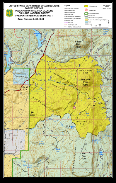
InciwebPole Canyon Fire Closure Map
This fire is in Fishlake National Forest. It’s 360 acres and 50 percent contained, according to NIFC. It’s 10 miles northeast of Loa at 38.464 latitude, -111.489 longitude. It’s listed on NIFC but Inciweb is no longer updating details about the fire.
Riggs Fire
The Riggs Fire in Dixie National Forest was 587 acres as of September 14, SU Independent reported. (But on September 15, Inciweb reported that it was now 766 acres.)
This fire is listed on Inciweb with the Lonely fire. Inciweb noted: “There are three trail closures currently in place. Within the Dixie National Forest the Grandview Trail (066) from the Willis Creek junction to Lower Podunk. In Bryce Canyon National Park the Riggs Spring Loop Trail is closed, including the connector trail from Riggs Springs to the Grandview Trail. The Under-the-Rim Trail is also closed from Agua Canyon to Rainbow Point. These trails are temporarily closed for the safety and welfare of the public”
Rose Crest Fire
This fire is listed on Utah Fire Info’s map. It is 80 acres. However, local sources stated a few days ago that the fire was 100 percent contained.
READ NEXT: See video and photos of the Herriman fire