
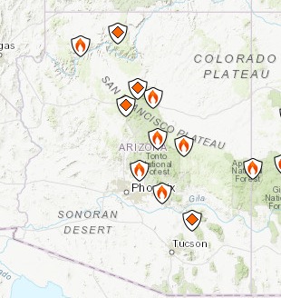
A number of active fires are burning right now in Arizona as of June 11, 2019. Read on for more details.
According to Inciweb, multiple wildfires are burning in Arizona.
InciwebArizona Fire
You can see an interactive fire map for the Arizona area here, provided by NWCG.gov. An embedded version is below, but click on the link to see a full version.
Here are the fires currently in Arizona. Many of them are prescribed fires that are set purposefully by officials to help prevent bigger wildfires from starting and spreading. These fires are listed in alphabetical order.
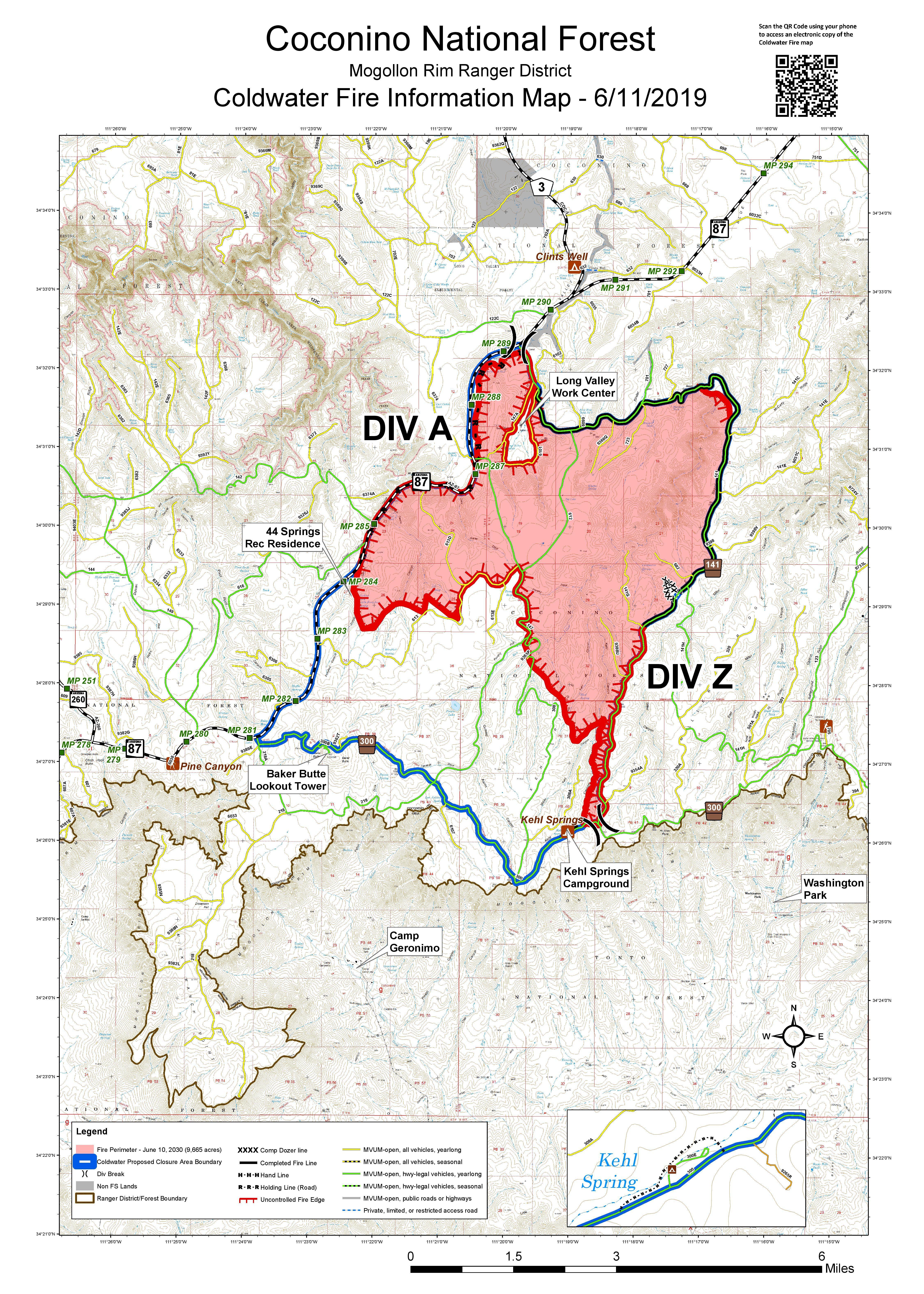
Coldwater Fire *
Inciweb
This fire is 9,665 acres and 15 percent contained as of June 11, according to Inciweb. Inciweb noted that visibility was low last night due to smoke and moisture from a passing storm.
The fire was caused by lightning and is four miles south of Clints Well.
Inciweb noted on June 11:
Motorists traveling along state Route 87 should expect smoke to be moderate to heavy at the intersection of SR87 and Lake Mary Road each morning between 3 a.m. and 9 a.m. Heavy fire traffic along SR87 is also possible at times, so motorists are encouraged to stay in their lane and follow pilot cars. Intermittent smoke is possible each afternoon, in and around the fire location and along SR87, between mileposts 283 and 293.
Smoky conditions in Pine should improve by late morning as southwest winds develop over the fire, pushing smoke toward the northeast. Smoke moving toward the northeast could impact areas along Interstate 40, including Winslow and Holbrook, where moderate air quality is possible during morning hours and will improve during the afternoon.
Air quality in these areas Wednesday morning could briefly drop to moderate or unhealthy for sensitive groups. For more information about how smoke from fires can affect your health, please visit www.airnow.gov/index.cfm?action=smoke.index.
The fire is being monitored and managed.
Appaloosa Fire
This fire broke out near Desert Ridge north of Phoenix, AZ Family noted. It grew to about 45 acres in size and isn’t currently listed on Inciweb. It’s 60 percent contained with no homes or structures threatened.
Bylas Fire
Yesterday the Bylas fire closed Highway 70 in Gila Valley temporarily. It’s near the community of Bylas between GLobe and Stafford. Later all lanes on 70 were reopened.
Our Type 6 Eng. has been called to the #BylasFire near San Carlos. A crew of 3 leave tomorrow. Prayers for a safe return please.
According to NIFC, the fire is 300 acres and 0 percent contained, 25 miles northwest of Datil.
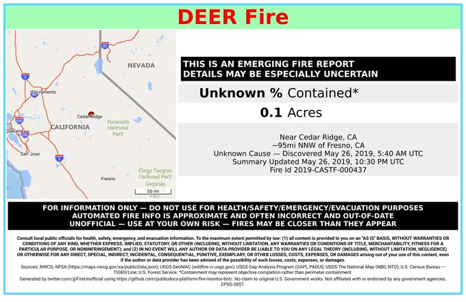
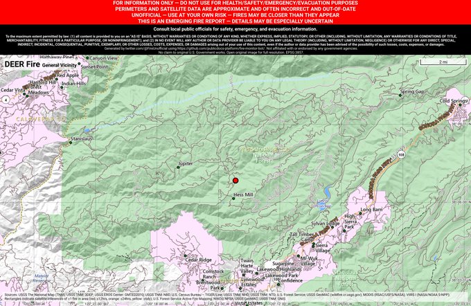
Deer Fire
#DeerFire 🔥 discovered May 26, 2019, 5:40 AM UTC – unofficial report.
#TuolumneCounty @stanislaus_nf; Near Cedar Ridge, CA. ~95mi NNW of Fresno, CA. See officials for safety info. May be incorrect; disclaimers in images.
This fire is listed at NIFC. It’s in the Apache-Sitgreaves National Forest and is 570 acres and 0 percent contained. It’s eight miles south of Alpine.
Hoyle Fire
This fire is 100 percent contained but still listed on Inciweb’s site. It was caused by lightning and grew to 503 acres. Some smoke may still be visible.
Kaibab NF Prescribed Fires
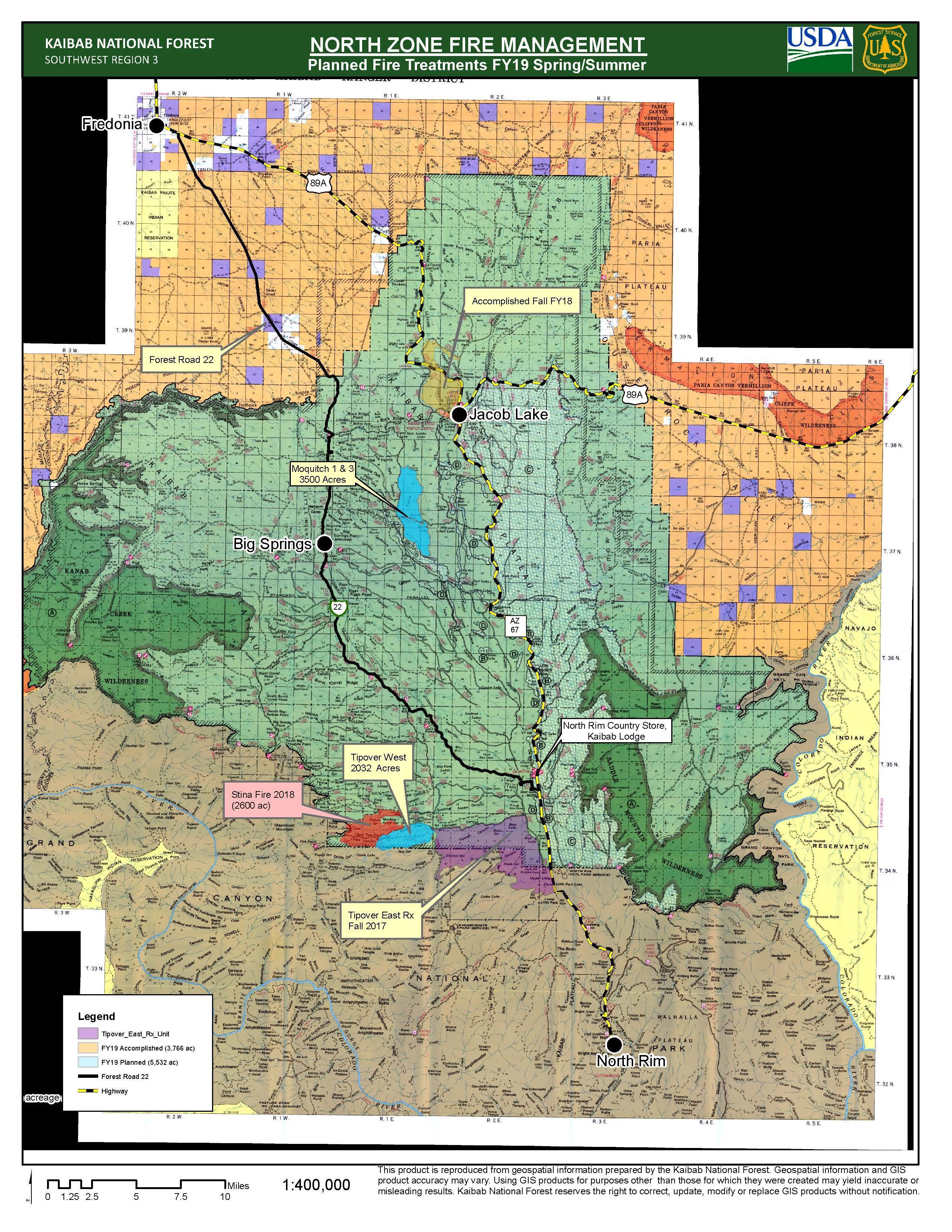
Kaibab Fire
This is a prescribed fire, listed on Inciweb. It’s 10 miles southeast of Williams. On June 10 Inciweb noted: ” Fire managers for the North Kaibab Ranger District of the Kaibab National Forest are tracking opportunities to pursue three prescribed fires at various locations across the district through the end of this month. Pending the appropriate fuel moistures and weather conditions, fire managers anticipate having an opportunity to begin burning in about one to two weeks and possibly continue into monsoon season.”
Maroon Fire
This wildfire is currently 8,605 acres and is about 18 miles northeast of Flagstaff off Leupp Road near Maroon Crater, Inciweb noted. It’s 88 percent contained, so the size has stopped increasing while containment has increased over the last several days.
Inciweb notes that the fire has transitioned back to a Type 4 fire, allowing resource numbers to be scaled back. “Containment will continue to increase over the next few weeks as firefighters identify and extinguish sources of heat along containment lines. Crews will continue with the removal of hazardous trees along travel corridors for public and firefighter safety.”
This fire is unique because the Maroon Crater was used for WWII artillery training and unexploded ordnance might still be off the designated roads, Inciweb noted. The fire has transitioned back to a Type 4 fire and fire teams will continue to secure holding features and reduce fire-related roadway hazards.
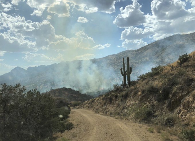
Mountain Fire
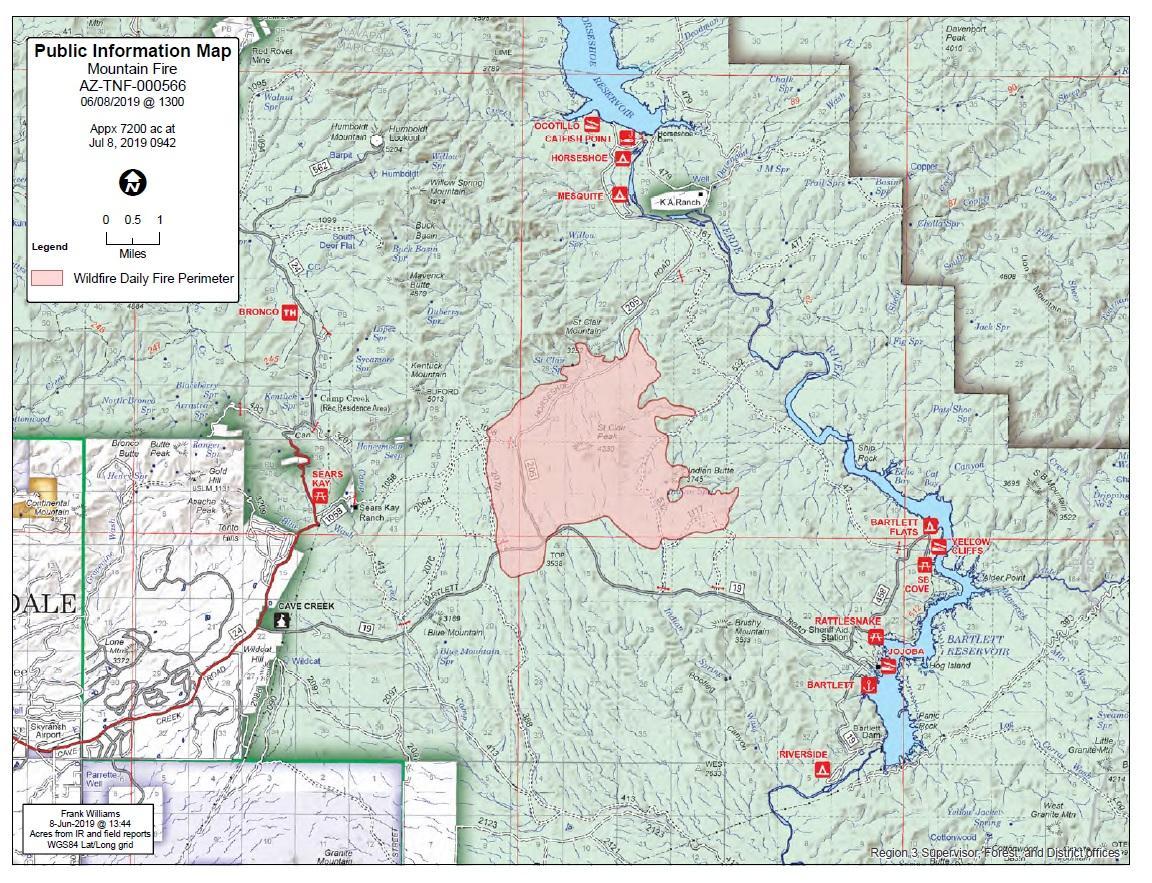
InciwebMountain Fire Map
This fire is 7,470 acres as of June 8 at 5:11 p.m. and 53 percent contained. So growth has slowed and containment increased over the last few days. It was caused by human activity with the exact cause under investigation. It’s eight miles east of the Cave Creek Ranger District Office. It was first reported June 7 at noon and is completely in the Tonto National Forest, burning east and northeast toward Horseshoe and Bartlett Lake, Inciweb noted. The map above is from June 8 and not much has changed since then except containment has increased nearly 50 percent.
Inciweb noted: “Bartlett Dam Road is now open for public use. Bartlett Lake Recreation Area and Horseshoe Lake Recreation Areas, are also open to the public. Please be careful driving along the Bartlett Dam and Horseshoe Dam roads and we ask that you don’t stop along the roadway, or walk around in the burned areas. Also, there may still be smoke visible throughout the day, due to interior pockets of fuel igniting.”
Roaring Fire
This fire is lightning caused and started June 5. It’s off US Highway 180 north of Luna Wok Center. It’s 400 acres and burning west of Bill Lee Mesa in New Mexico, near the border with Arizona.
Slide Fire
This fire started May 1 and has not been updated on Inciweb since May 7. It was caused by lighting and is being managed. It is not an out-of-control fire. It’s 72 acres and burning 65 miles south of St. George, Utah.
Spring/Summer Prescribed Fire
This is another prescribed fire burning 10 miles north of Flagstaff. The size is about 1,190 acres and it will be a one-day operation.
Woodbury Fire in Tonto National Forest

Inciweb
The Woodbury fire is in the Superstition Mountains northwest of Superior, Arizona. It was 150 acres as of the evening of June 8 and has since grown to 5,000 acres as of June 11. The fire is human caused.
The fire is still strong but we have amazing support from all the firefighters on the front line… thanks for all you guys are doing! The command center is staged in Queen Valley and doing a great job keeping everyone informed #TontoNF #WoodburyFire #AZFire #azwildfire
Inciweb noted: “The Woodbury Fire was reported to the Tonto National Forest on June 8, Saturday afternoon. Located approximately five miles northwest of Superior, Arizona, the fire is burning in steep, rugged, remote terrain in and near the Superstition Wilderness. The fire continues to burn actively day and through the evening. The Public is being asked to stay away from the area, including the Woodbury and Roger’s Trough trailheads to allow firefighters to safely build fireline.
Smoke will be visible from Highway 60 and communities nearby.
This is a developing story.