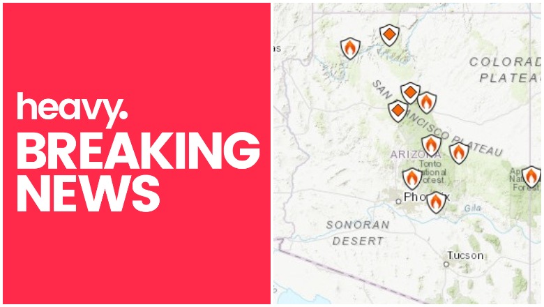
Inciweb Arizona Fire Map
Active fires are still burning in Arizona as of June 15, 2019. These include the large Woodbury fire, the Coldwater fire, and more. Read on for details.
According to Inciweb, multiple wildfires are burning in Arizona.
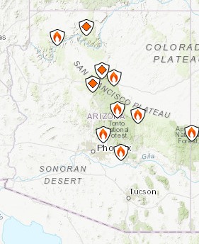
InciwebArizona Fire Map
You can see an interactive fire map for the Arizona area here, provided by NWCG.gov. An embedded version is below, but click on the link to see a full version.
Here are the fires currently in Arizona. Some of them are prescribed fires that are set purposefully by officials to help prevent bigger wildfires from starting and spreading. These fires are listed in alphabetical order.
Bylas Fire
The Bylas fire closed Highway 70 in Gila Valley temporarily on June 12. It’s near the community of Bylas between Globe and Stafford. Later all lanes on 70 were reopened.
According to NIFC, the fire is 340 acres and 52 percent contained, 25 miles northwest of Datil.
Coldwater Fire
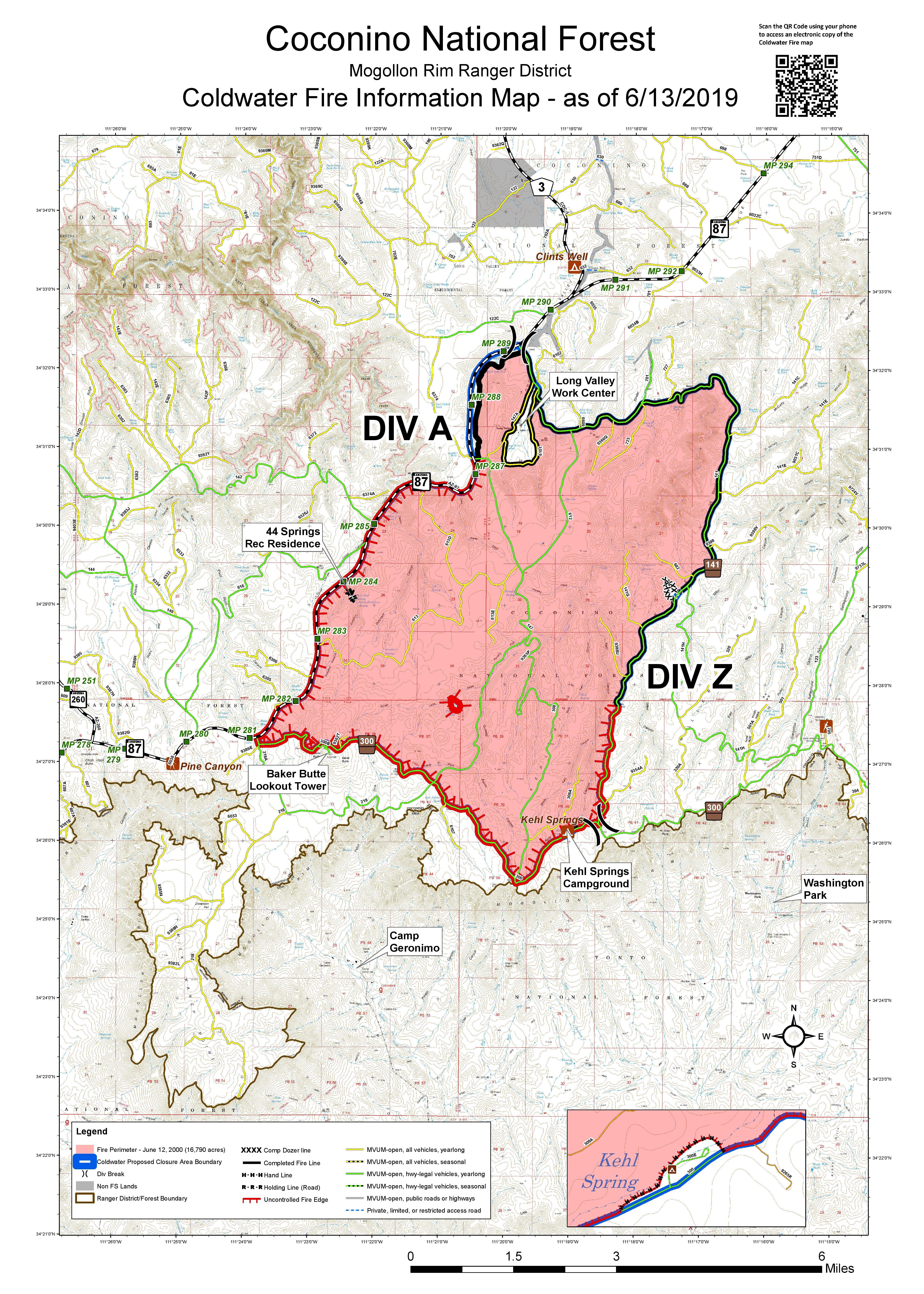
This fire grew from 9,665 acres on June 11 but to 16,790 acres as of June 13, according to Inciweb. As of June 14 at 11:25 a.m., the fire was the same size and still at 30 percent containment.
The fire was caused by lightning and is four miles south of Clints Well.
Although the fire is still large in size with just 30 percent containment, the risk of the fire spreading has diminished enough for it to be reduced from a Type III to a Type IV fire. Inciweb noted on June 14:
“The Type III incident management team has completed all burnout operations and their work on the 16,790-acre Coldwater Fire and will return fire operations to the Mogollon Rim Ranger District as a Type IV incident at 6 p.m. tonight. The number of resources assigned to the fire is being reduced, as the risk of fire moving out of its perimeter has greatly diminished. The personnel assigned to the fire will patrol and monitor the perimeter and remaining fire activity. Containment will continue to increase over the next few weeks as firefighters identify and extinguish sources of heat along containment lines. Crews will continue with the removal of hazardous trees along travel corridors for public and firefighter safety.”
A temporary forest closure is still in place due to risk from fire-weakened trees or burning debris. Minimal smoke from the fire will still be seen for the next few weeks.
Deer Fire
This fire is listed at NIFC. It’s in the Apache-Sitgreaves National Forest and is 1,905 acres and 80 percent contained, eight miles south of Alpine.
Hells Gate Fire
Wildfire update: Windmill, 94 acres, 90% contained; Hell’s Gate, 336 acres, 70% contained; Saucito, estimated 45 acres, 50% contained. Last update unless activity picks up. More info at t.co/ZnJGrqczQ6
Red Flag Warning today, be careful with fire today and every day!
This fire is listed at NIFC. It’s 10 miles northwest of Superior and is being overseen by the Coronado National Forest. It’s 336 acres and 90 percent contained with little visible activity.
Kaibab Prescribed Fires
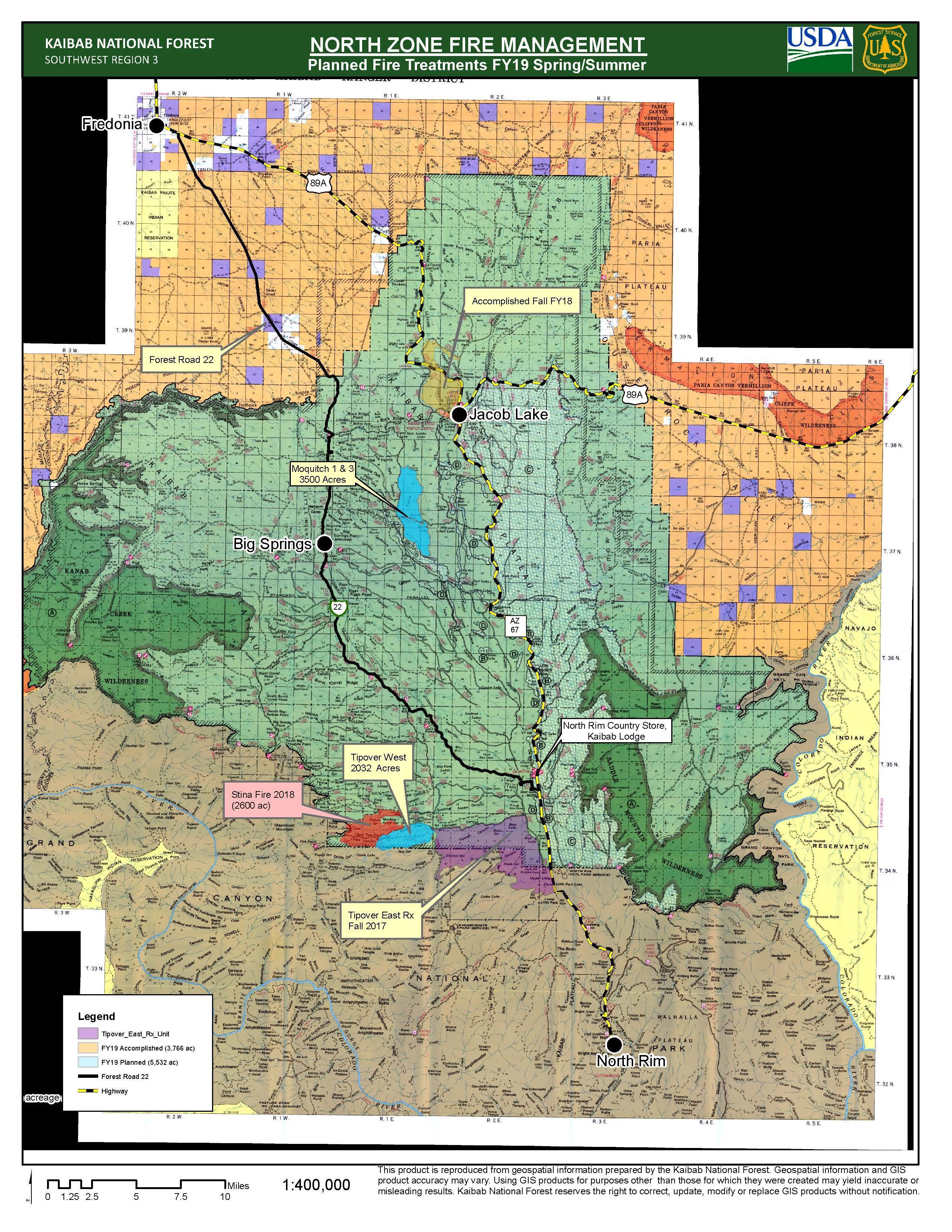
Kaibab Fire North – Map from June 10, 2019
This is a prescribed fire, listed on Inciweb and divided into north and south zones. The map above is the north zone.
It’s 10 miles southeast of Williams. On June 10 Inciweb noted about the north zone: “Fire managers for the North Kaibab Ranger District of the Kaibab National Forest are tracking opportunities to pursue three prescribed fires at various locations across the district through the end of this month. Pending the appropriate fuel moistures and weather conditions, fire managers anticipate having an opportunity to begin burning in about one to two weeks and possibly continue into monsoon season.”
The south zone will be 2,500 acres. Inciweb wrote on June 7:
Fire managers on the south zone of the Kaibab National Forest will continue operations on multiple prescribed fire projects on both the Williams and Tusayan Ranger Districts over the next several days and into next week as conditions remain optimal for beneficial burn treatments.
The Sunflower Rx project south of Williams began on Monday, June 10. On Tuesday, June 11, fire personnel have completed all planned ignitions on the prescribed fire and will continue to monitor the area the rest of the week. Light smoke may be present over the next few days.
On the Reed Rx project near Tusayan, approximately 1,095 acres have been completed to date. For Friday, June 14, the plan is to finish this section with another 308 acres to burn. For this prescribed fire, no planned burning will take place over the weekend, however, the prescribed burning operation may resume possibly sometime next week.
Maroon Fire
This wildfire is currently 8,605 acres and is about 18 miles northeast of Flagstaff off Leupp Road near Maroon Crater, Inciweb noted in its last update about the fire on June 10. It’s 88 percent contained as of June 10 (the latest update), so the size has stopped increasing while containment has increased over the last several days.
Inciweb notes that the fire has transitioned back to a Type 4 fire, allowing resource numbers to be scaled back. “Containment will continue to increase over the next few weeks as firefighters identify and extinguish sources of heat along containment lines. Crews will continue with the removal of hazardous trees along travel corridors for public and firefighter safety.”
This fire is unique because the Maroon Crater was used for WWII artillery training and unexploded ordnance might still be off the designated roads, Inciweb noted. The fire has transitioned back to a Type 4 fire and fire teams will continue to secure holding features and reduce fire-related roadway hazards.
Mountain Fire
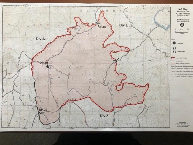
InciwebMountain Fire Map from June 10
This fire is 7,470 acres as of June 14 at 2:34 p.m. and 57 percent contained. This means that the size has stayed the same for the last couple of days and containment has increased.
The fire was caused by human activity with the exact cause under investigation. It’s eight miles east of the Cave Creek Ranger District Office. It was first reported June 7 at noon and is completely in the Tonto National Forest, burning east and northeast toward Horseshoe and Bartlett Lake, Inciweb noted.
Inciweb noted: “Bartlett Dam Road is now open for public use. Bartlett Lake Recreation Area and Horseshoe Lake Recreation Areas, are also open to the public. Please be careful driving along the Bartlett Dam and Horseshoe Dam roads and we ask that you don’t stop along the roadway, or walk around in the burned areas. Also, there may still be smoke visible throughout the day, due to interior pockets of fuel igniting. ”
Roaring Fire
This fire is lightning-caused and started on June 5. It’s off US Highway 180 north of Luna Wok Center. It’s 400 acres and burning west of Bill Lee Mesa in New Mexico, near the border of Arizona. It’s now 100 percent contained.
Slide Fire
This fire started May 1 and has not been updated on Inciweb since May 7. It was caused by lighting and is being managed. It is not an out-of-control fire. It’s 72 acres and burning 65 miles south of St. George, Utah.
Spring/Summer Prescribed Fire w
This is another prescribed fire burning 10 miles north of Flagstaff. The size is about 1,190 acres and it will be a one-day operation.
Windmill Fire
This fire is 94 acres and 90 percent contained, according to Coronado National Forest. No additional spread and little visible smoke from this fire.
Woodbury Fire in Tonto National Forest (Superstition Mountains)
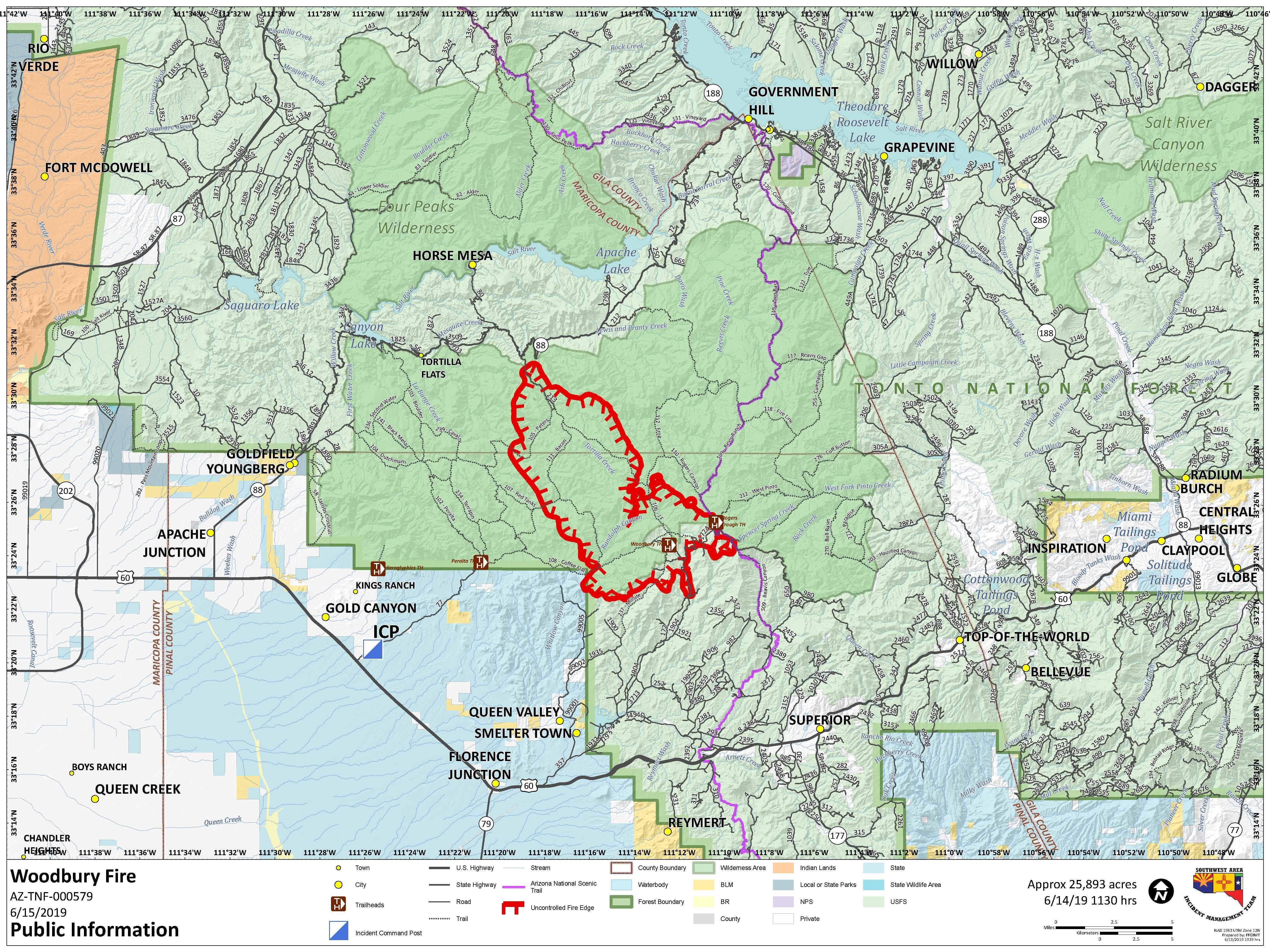
InciwebWoodbury Fire Map from June 15
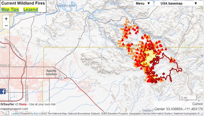
The Woodbury fire is in the Superstition Mountains northwest of Superior, Arizona. It was 150 acres as of the evening of June 8 and was 5,000 acres as of June 11. On June 13 it was 10,090 acres and now, as of June 15, it’s exploded in size to 25,893 acres because of an unexpected dryline.
Woodbury Fire is now 25,893 acres. Here’s a satellite comparison of June 5th vs yesterday (June 14th). Can clearly see the fire scars from the #WoodburyFire and #MountainFire. #azwx #azfire
The fire is five miles northwest of Superior, Arizona. It is human-caused.
Saturday 6/15 #WoodburyFire AZ 25,893 acres per NIFC FTP site. There was an overflight last night but the infrared scanner malfunctioned. Therefore the perimeter shown on the map is still from the Thursday night infrared data. Open #GISsurfer map: t.co/iJY9P8CQ9r #AZfire
Inciweb noted on June 14 that weather will help the fire continue to grow. “Excessive heat and dry conditions will coninue to keep fuel moisture at 1% with probability of ignition at 100%. Ho and dry conditions have contribued to exended burn periods with observations of continuous fire activity overnight. Exreme heating and the presence of large reservoirs in narrow canyons may be increasing burn periods and nocturnal downslope winds.”
Consistent south/southwest winds will help the fire spread where complex topography helps the fire activity last. A change in brush may also help the fire spread in the northeast.
Inciweb noted the morning of June 15: “There are currently no threats to the communities of Queen Valley Estates, Gold Canyon, Kings Ranch, Superior, and Apache Junction. Firefighting efforts on the north end of the fire will concentrate on protecting campgrounds, infrastructure, powerlines, and businesses along State Highway 88.”
Closures include:
- “State Highway 88 from Needle Vista east to the junction of State Highway 88 and State Highway 188.”
- This includes Tortilla Flat, Canyon Lake, Apache Lake, and campsite on State Highway 88 in the closure area.
A community meeting is planned for the fire on Sunday, June 16 at 2 p.m. at the Roosevelt Baptist Church on State Highway 188, Inciweb noted.