Inciweb
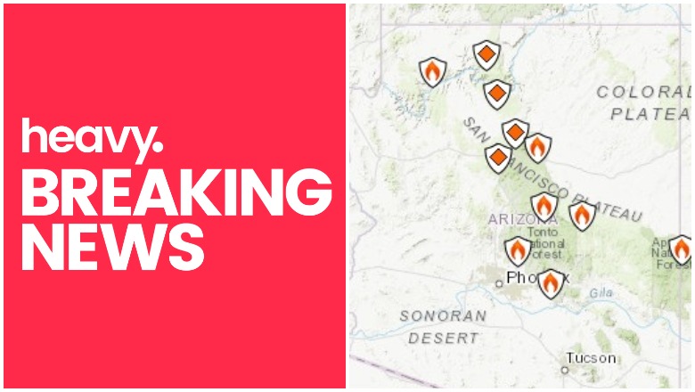
Active fires are still burning in Arizona as of June 18, 2019 and are creating problems with smoke and closures in affected regions. These include the large Woodbury fire, the Coldwater fire, and more. Read on for details.
According to Inciweb, multiple wildfires are burning in Arizona right now.
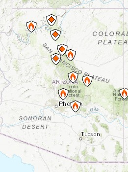
You can see an interactive fire map for the Arizona area here, provided by NWCG.gov. An embedded version is below, but click on the link to see a full version.
Here are the fires currently in Arizona as of June 18, 2019. Some of them are prescribed fires that are set purposefully by officials to help prevent bigger wildfires from starting and spreading. These fires are listed in alphabetical order.
Bylas Fire
The Bylas fire closed Highway 70 in Gila Valley temporarily on June 12. It’s near the community of Bylas between Globe and Stafford. Later all lanes on 70 were reopened.
According to NIFC, the fire is 340 acres and 73 percent contained, 25 miles northwest of Datil.
Coldwater Fire
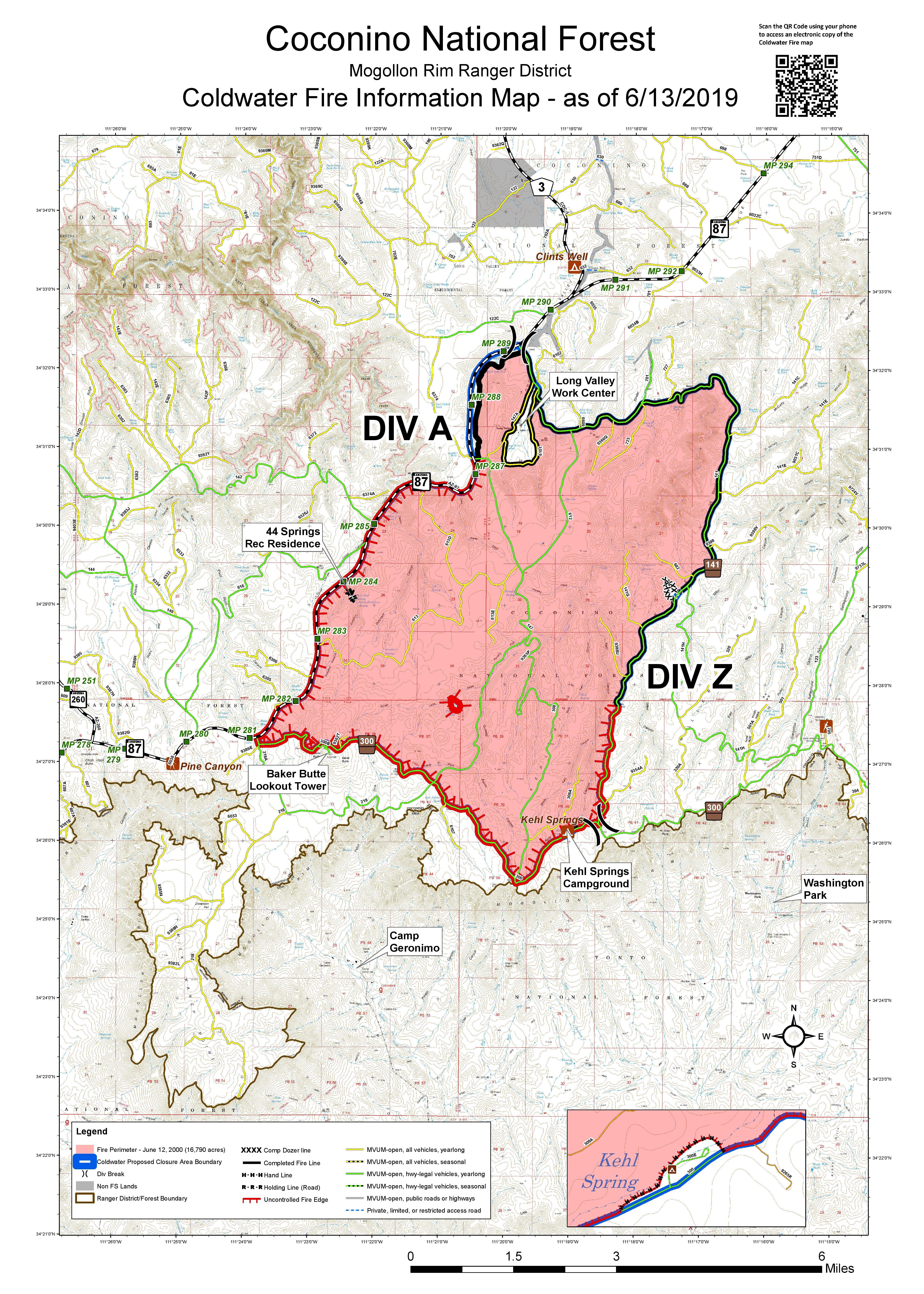
This fire grew from 9,665 acres on June 11 but to 16,790 acres as of June 13, according to Inciweb. As of June 18 at 12:48 p.m., it is still 16,790 acres, but the good news is that it’s now 90 percent contained. The map above, from June 13, is the most recent map.
The fire was caused by lightning and is four miles south of Clints Well.
Inciweb noted: “Fire personnel with the Mogollon Rim Ranger District are currently monitoring the perimeter and remaining fire activity of internal smoldering pockets. A temporary forest closure remains in effect to ensure no one is injured or killed by the fire-weakened trees, burning debris and stump holes present in the interior of the fire. To review the closure go to https://go.usa.gov/xmJFV. The public can expect to see minimal smoke from the Coldwater Fire for a few more weeks, but nothing substantial.”
Hoyle Fire
This fire is still listed as active on Inciweb. As of June 10, it was listed as 503 acres and 100 percent contained.
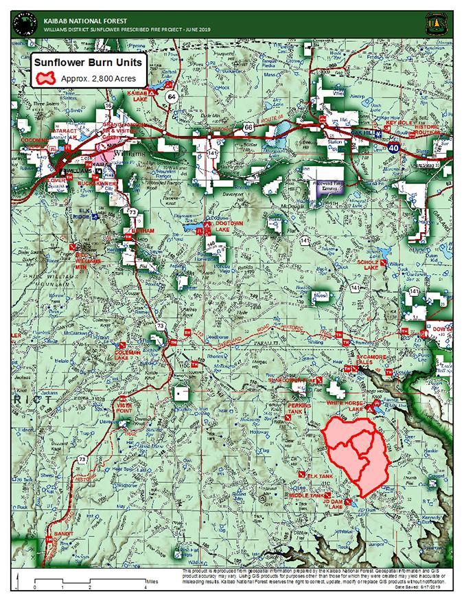
Kaibab Prescribed Fires (North and South Zones)
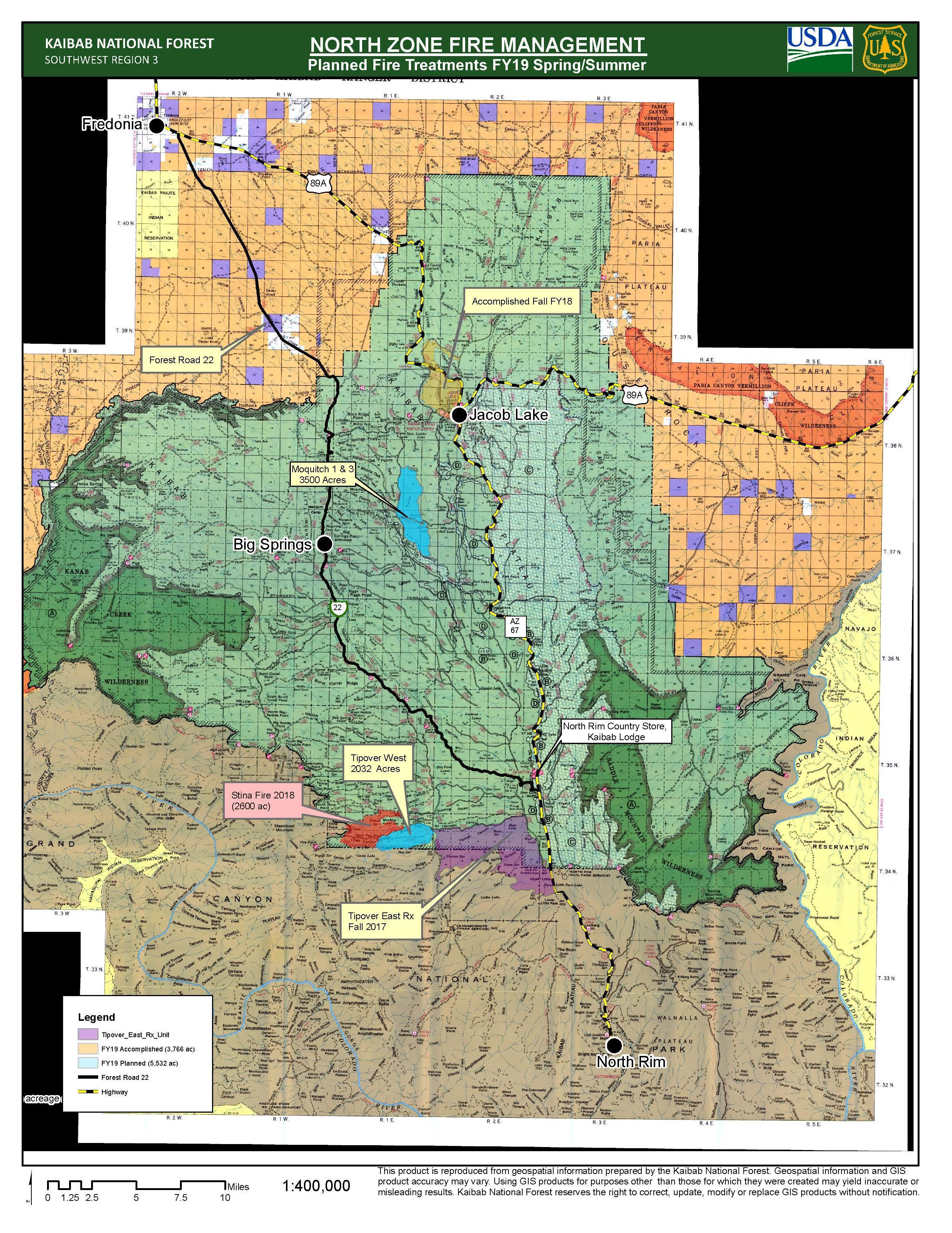
Kaibab Fire North – Most recent map from June 10, 2019
This is a prescribed fire, listed on Inciweb and divided into north and south zones. The map above is the north zone and it’s the most recent map released by Inciweb.
It’s 10 miles southeast of Williams. On June 17 Inciweb wrote: “Fire managers for the North Kaibab Ranger District of the Kaibab National Forest plan to initiate the Moquitch-1 and Moquitch-3 (Phase 2) prescribed burn units as early as Wednesday if weather, resources, and fuel moisture conditions remain favorable to assure firefighter and visitor safety, while still achieving the desired objectives outlined during the planning process. As fuel moisture levels fall within prescriptive parameters, firefighters will focus on treating approximately 3,500 acres between the two prescribed burn units.”
Here’s a map of the south zone.
Inciweb
Inciweb wrote on June 17: ” Fire managers on the South Zone of the Kaibab National Forest will continue operations on multiple prescribed fire projects on both the Williams and Tusayan Ranger Districts over the next several days and into next week as conditions remain optimal for beneficial prescribed fire treatments. Crews are currently working on the Sunflower Prescribed Fire project located approximately eight miles southeast of Williams.”
Long Jim I & III Prescribed Fire
This is a new prescribed fire in the Grand Canyon region to help prevent out-of-control fires.
Maroon Fire
This wildfire is currently 8,206 acres and is about 18 miles northeast of Flagstaff off Leupp Road near Maroon Crater, Inciweb noted in its last update about the fire on June 18. It’s 80 percent contained as of June 18. The fire was caused by lightning and is 18 miles northeast of Flagstaff, off Leupp Road near Maroon Crater, Inciweb noted.
Inciweb notes that the fire has transitioned back to a Type 4 fire, allowing resource numbers to be scaled back. However, the work isn’t completely over, KTAR noted on June 16. The focus is on controlling and managing the fire rather than putting it out, KTAR reported.
Amidst the sweet-smelling smoke of ponderosa pine, wildland firefighters are laboring to maintain – not extinguish – a wildfire burning in the Coconino National Forest northeast of Flagstaff.

This fire is unique because the Maroon Crater was used for WWII artillery training and unexploded ordnance might still be off the designated roads, Inciweb noted. The fire has transitioned back to a Type 4 fire and fire teams will continue to secure holding features and reduce fire-related roadway hazards.
Mountain Fire
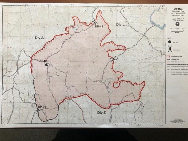
InciwebMountain Fire Map from June 10, before the fire was 100 percent contained.
This fire is 7,470 acres as of June 18 at 12:03 p.m. and 100 percent contained.
The fire was caused by human activity with the exact cause still under investigation. It’s eight miles east of the Cave Creek Ranger District Office. It was first reported June 7 at noon and was completely in the Tonto National Forest.
Inciweb noted on June 18: “The Mountain Fire, 8 miles east of Cave Creek Ranger District office, is now 100 percent contained. Crews are on-site patrolling and conducting suppression rehabilitation work. Ash and dust whirlwinds may be visible. If you see smoke in the area of the fire, you are encouraged to call Phoenix Interagency Fire Center Dispatch at (480) 457-1555.”
Roaring Fire
This fire is lightning-caused and started on June 5. It’s off US Highway 180 north of Luna Wok Center. It’s 400 acres and burning west of Bill Lee Mesa in New Mexico, near the border of Arizona. It’s now 100 percent contained but still listed as active on Inciweb.
Slide Fire
This fire started May 1 and has not been updated on Inciweb since May 7, although it’s still listed on Inciweb as active. It was caused by lighting and is being managed. It is not an out-of-control fire. It’s 72 acres and burning 65 miles south of St. George, Utah.
Spring/Summer Prescribed Fire
This is another prescribed fire burning 10 miles north of Flagstaff. The size is about 1,190 acres and it will be a one-day operation.
Woodbury Fire in Tonto National Forest (Superstition Mountains)
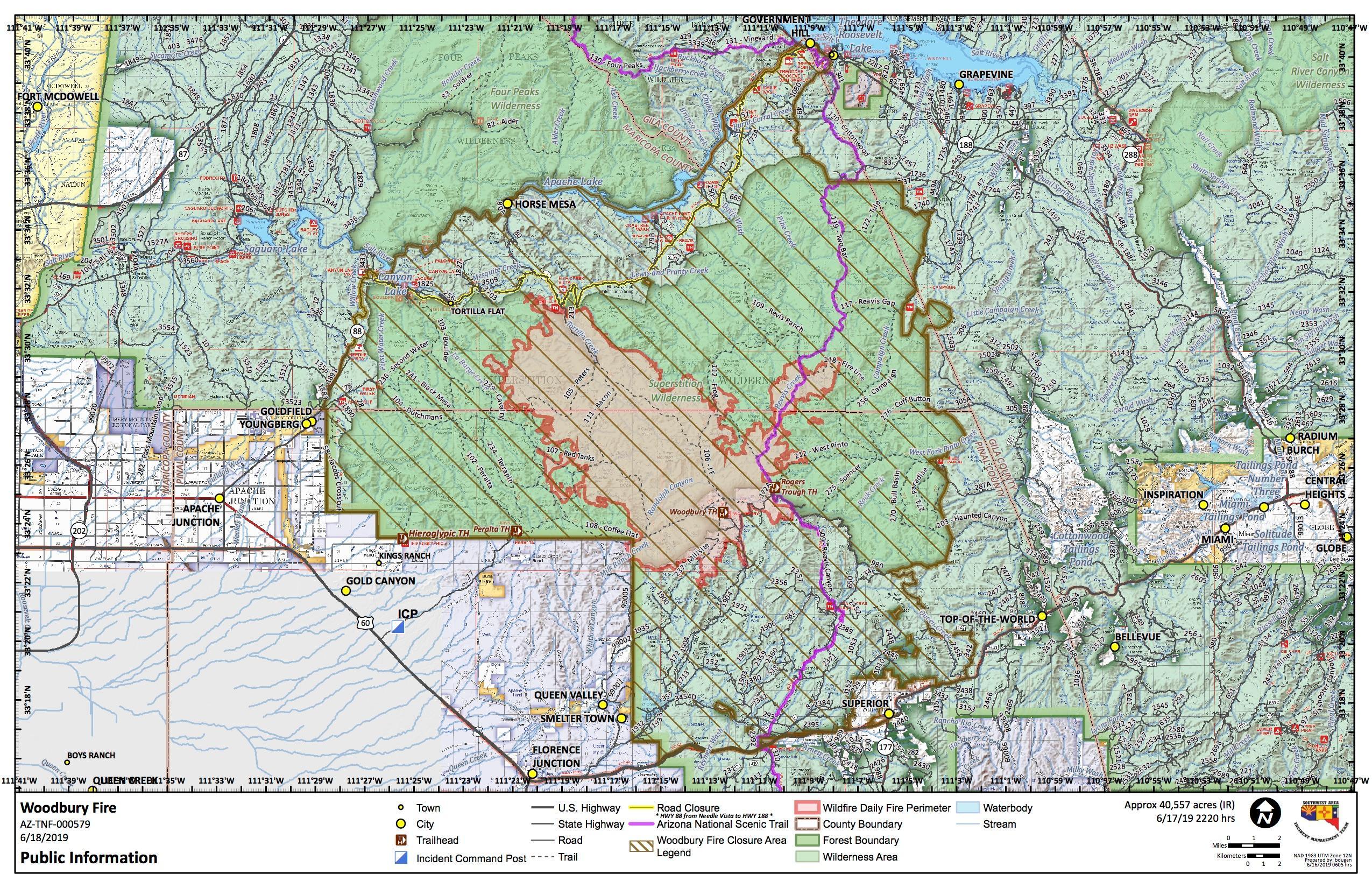
InciwebWoodbury Map
The Woodbury fire is in the Superstition Mountains northwest of Superior, Arizona. It’s been the most troublesome of Arizona fires lately. It was 150 acres as of the evening of June 8 and was 5,000 acres as of June 11. On June 13 it was 10,090 acres and on June 15 it was 25,893 acres because of an unexpected dryline. Now, as of June 18, it’s 40,557 acres in size and just 6 percent contained.
The following embedded map of the fire is provided by MappingSupport.com and Joseph Elfelt.
The fire is five miles northwest of Superior, Arizona. It is human-caused.
According to Inciweb, triple-digit temperatures over the next few days and single-digit humidity, along with increasing winds, might cause the fire behavior to increase in the coming days.
No evacuations have been ordered for this fire as of June 18.
On June 18 Inciweb wrote: “Where the fire has progressed toward Reavis ranch, it remains about 10 miles from the Roosevelt area. Other than the closure of State Highway 88 (Apache Trail) ordered earlier, no evacuations have been ordered for this fire. If future evacuations are determined to be needed in the Roosevelt Lake area, the Gila County Sheriff’s office will issue such an order and make notifications. None are imminent presently. Residents along State Highway 188 will observe substantial smoke today when fire activity increases in the afternoon. No immediate threat exists for Apache Junction, Gold Canyon, Queen Valley or other southern communities.”
Closures include:
- “State Highway 88 is closed from Needle Vista east to the junction of State Highway 88 and State Highway 188. This includes Tortilla Flat, Canyon Lake, Apache Lake, and campsites along Apache Lake.”