Inciweb
Fires continue to cause issues in Arizona on June 29-30, 2019. Read on for details about the fires, their locations, containment size, maps, and more. As news can change quickly, be sure to watch your local news for the latest evacuation details.
According to Inciweb, a number of wildfires are burning in Arizona right now on June 29-30. You can see an interactive fire map for the Arizona area, provided by NWCG.gov. An embedded version is below, but click on the link to see a full version.
Here are the fires currently in Arizona as of June 29-30, 2019, listed in alphabetical order, so the Woodbury Fire is at the end of this article. Some of them are prescribed fires that are set purposefully by officials to help prevent bigger wildfires from starting and spreading. Others are wildfires that you’ll want to keep a closer eye on. Remember that evacuation details can change rapidly, so stay tuned to your local news for updates. We will update this story again later in the day.
Badger Springs Fire
Inciweb has great news for this fire. As of June 29 at 1:20 p.m., the fire is 100 percent contained at 2,525 acres. It is seven miles south of Cordes Junction.
The cause of the fire is human activity and it’s under investigation.
Coldwater Fire
This fire grew from 9,665 acres on June 11 to 16,790 acres as of June 13, according to Inciweb. As of June 18 at 12:48 p.m., it was still 16,790 acres, but the good news is that it’s now 90 percent contained. The map above, from June 13, is the most recent map. Inciweb was last updated about this fire on June 18.
The fire was caused by lightning and is four miles south of Clints Well.
Inciweb noted: “Fire personnel with the Mogollon Rim Ranger District are currently monitoring the perimeter and remaining fire activity of internal smoldering pockets. A temporary forest closure remains in effect to ensure no one is injured or killed by the fire-weakened trees, burning debris and stump holes present in the interior of the fire. To review the closure go here. The public can expect to see minimal smoke from the Coldwater Fire for a few more weeks, but nothing substantial.”
Gap Fire
This fire is listed on NIFC’s website, not Inciweb. It’s 16,711 acres and 60 percent contained, located 10 miles northeast of Bylas. Other sources indicate it might now be 70 percent contained.
#GapFire 🔥 unofficial update.
~10mi NE of Bylas, AZ. ⚠️ DO NOT USE FOR SAFETY PURPOSES – See officials instead. May be incorrect; disclaimers in images.


Hoyle Fire
This fire is still listed as active on Inciweb. As of June 10, it was listed as 503 acres and 100 percent contained.
Kaibab Prescribed Fires (North and South Zones)
Inciweb
This is a prescribed fire, listed on Inciweb and divided into north and south zones. The map above is the north zone and it’s the most recent map released by Inciweb.
It’s 10 miles southeast of Williams. On June 20 Inciweb wrote: “Ignitions are complete on the Moquitch-3 (Phase 2) prescribed fire project at the North Kaibab Ranger District on the Kaibab National Forest. Fire managers have reported a total of 1,436 acres treated over the past two days.”
Inciweb wrote on June 25 regarding the south zone:
The Russell Prescribed Fire project located approximately 13 miles southeast of Tusayan fire treatments have halted for now due to weather conditions. The identified area is 2,130 acres. Fire personnel will continue to patrol and monitor the area until deemed unnecessary.
The Sunflower Prescribed Fire project is located approximately 8 miles southeast of Williams near County Road 73. Fire crews will continue and monitor the project area as all ignitions have been completed.
On the Reed Prescribed Fire, approximately 3 miles northeast of Tusayan, crews will patrol and monitor the burned areas over the next several days.”
You can see maps of the south zone fires here.
The south zone fires include the Russell Prescribed Fire, the Sunflower Prescribed Fire, and the Reed Prescribed Fire.
Maroon Fire
This wildfire is currently 8,206 acres and is about 18 miles northeast of Flagstaff off Leupp Road near Maroon Crater, Inciweb noted in its last update about the fire on June 18. It’s 80 percent contained as of June 18, the last time Inciweb updated details about the fire. The fire was caused by lightning and is 18 miles northeast of Flagstaff, off Leupp Road near Maroon Crater, Inciweb noted.
Inciweb notes that the fire has transitioned back to a Type 4 fire, allowing resource numbers to be scaled back. However, the work isn’t completely over, KTAR noted on June 16. The focus is on controlling and managing the fire rather than putting it out, KTAR reported.
This fire is unique because the Maroon Crater was used for WWII artillery training and unexploded ordnance might still be off the designated roads, Inciweb noted. The fire has transitioned back to a Type 4 fire and fire teams will continue to secure holding features and reduce fire-related roadway hazards.
Mountain Fire
This fire is 7,470 acres as of June 18 at 12:03 p.m. and 100 percent contained. The last update on Inciweb was posted on June 18. The final acreage noted by Cal Fire on June 21 was much smaller at just 30 acres.
The fire was caused by human activity with the exact cause still under investigation. It was eight miles east of the Cave Creek Ranger District Office. It was first reported June 7 at noon and was completely in the Tonto National Forest.
Inciweb noted on June 18: “The Mountain Fire, 8 miles east of Cave Creek Ranger District office, is now 100 percent contained. Crews are on-site patrolling and conducting suppression rehabilitation work. Ash and dust whirlwinds may be visible. If you see smoke in the area of the fire, you are encouraged to call Phoenix Interagency Fire Center Dispatch at (480) 457-1555.”
Slide Fire
This fire started May 1 and has not been updated on Inciweb since May 7, although it’s still listed on Inciweb as active. It was caused by lighting and is being managed. It is not an out-of-control fire. It’s 72 acres and burning 65 miles south of St. George, Utah.
Woodbury Fire in Tonto National Forest (Superstition Mountains)
Inciweb
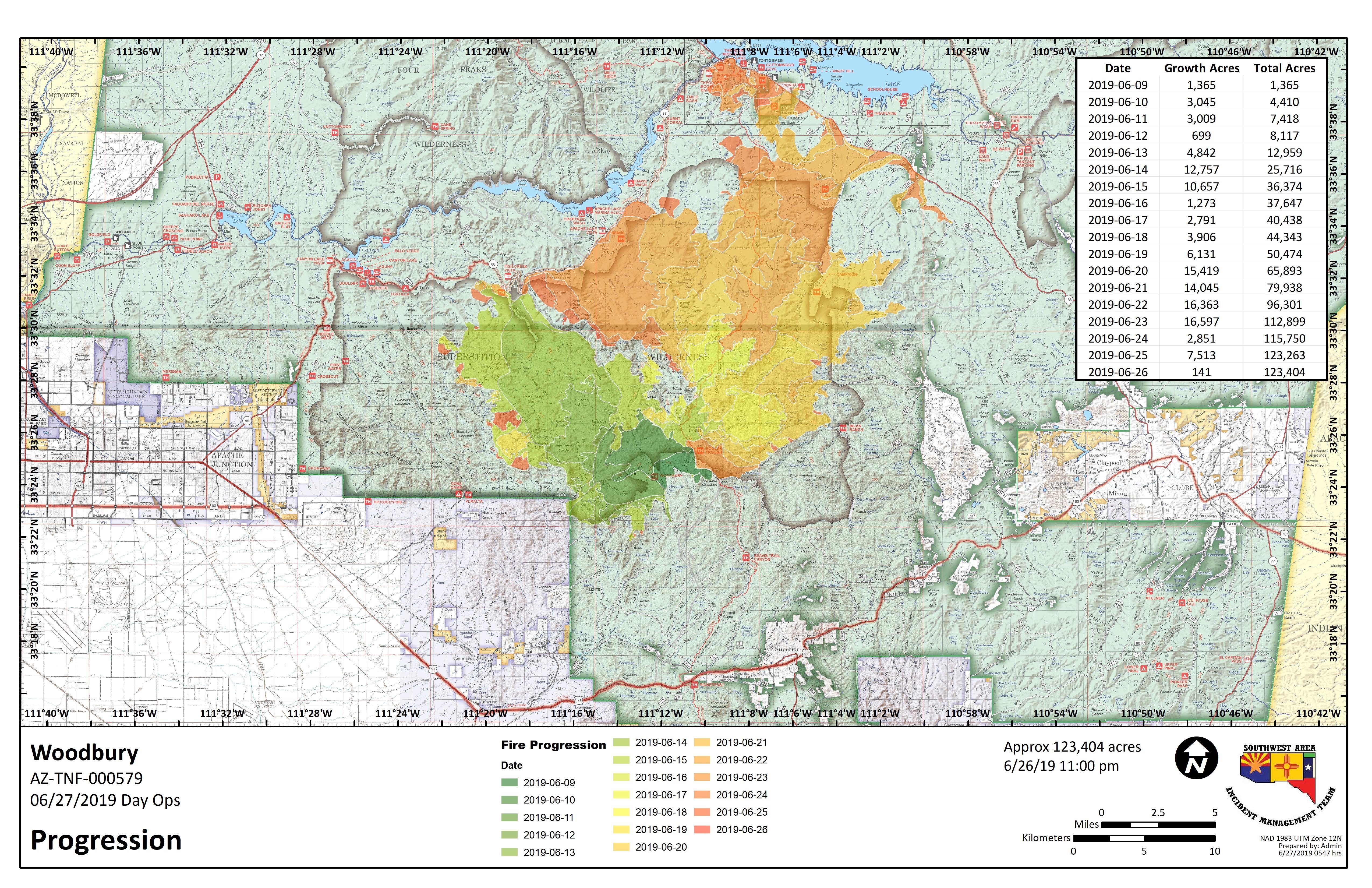
The Woodbury fire started out in the Superstition Mountains northwest of Superior, Arizona. It’s been the most worrisome of the Arizona fires. It was 150 acres as of the evening of June 8 and grew to 5,000 acres by June 11. On June 13 it was 10,090 acres and on June 15 it grew to 25,893 acres because of an unexpected dryline. On June 18 it was 40,557 acres in size and just 6 percent contained. On June 23, it was 96,307 acres.
As of Saturday, June 29 at 7:32 p.m., the fire is now 123,827 acres and 68 percent contained according to Inciweb. This means the fire has grown significantly but containment has also finally started increasing for the fire. We will update this story later on June 30 when Tonto Forest releases an update about the Woodbury Fire.
The following embedded map of the fire is provided by MappingSupport.com and Joseph Elfelt.
Smoke from this fire is still visible from U.S. Highway 60 and the communities around the Superstition Wilderness.
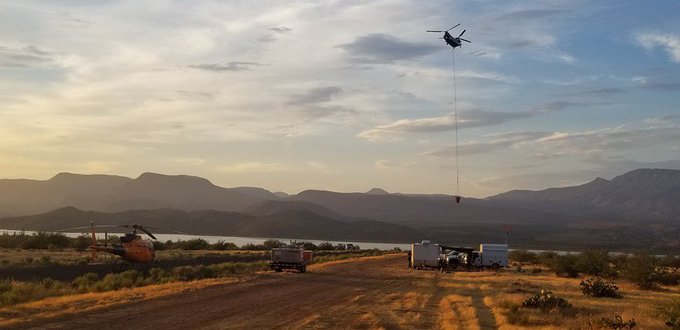
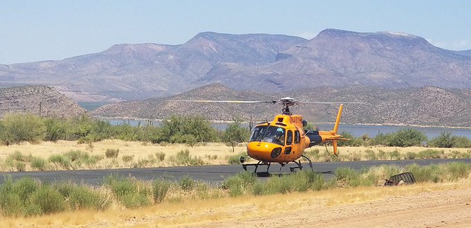
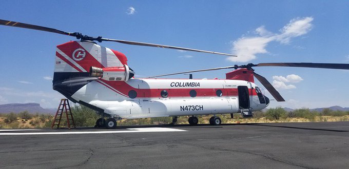
Helicopters continue to suppress hot spots along the edge of the Woodbury Fire. Take a look at some of the aircraft and tools that support firefighters from the Grapevine Helibase. (Woodbury Fire photos/Reid Barney) #WoodburyFire

Inciweb had previously noted that many structures were at risk, including the Tonto National Monument, powerlines, Pinto Valley and Carlotta mines, private residences, and commercial property. The good news is that while the danger is most definitely not yet gone, containment has progressed enough that command of the fire was able to be transferred on June 28 from Type 3 to Type 1. “As complexity of the incident decreases, the organization continues to right size the workforce with the gradual demobilization of resources.”
Here’s a look at the fire’s progression as of June 27, the most recent progression map available:
The Gila County Sheriff’s Office issued an evacuation alert on Thursday, June 20 for residents in the Roosevelt Lake area. On June 25, all evacuations were lifted.
As of the evening of June 29, closures include:
- The campsites of Burnt Corral, Crabtree Wash, Davis Wash, Lower Burnt Coral Shoreline Area, Three-Mile Wash, Upper Burnt Corral Shoreline Area
- State Highway 88 from Tortilla Flat to the State Highway 188 junction
- Apache Lake, Apache Campgrounds, picnic sites and trailheads
- Tonto National Forest Fire Area Closure information: https://bit.ly/31O2Ih4 Tonto National Forest Stage 1 Fire Restrictions remain in place.
- Tonto National Monument is closed.
Inciweb noted the following on June 29:
Yesterday storm systems near the fire area produced gusty outflow winds. The winds increased fire activity in the Fish Creek area and along the northwest perimeter of the fire near Pinyon Mountain. Containment remains at 68 percent. Fire crews continue to suppress hotspots along the fire’s edge. Smoke may be seen due to pockets of vegetation burning within the fire perimeter.
Suppression repair efforts are being conducted in all closed areas, such as chipping downed trees and hauling out equipment and debris to minimize the effects caused by the fire suppression.
A Burned Area Emergency Response (BAER) team is now in place on the Woodbury Fire. The purpose of the team is to identify and manage potential risks on National Forest System lands to human life and safety, property, critical natural or cultural resources. Their work reduces these threats through appropriate emergency measures. The team includes hydrologists, soil scientists, and other resources. For more information on Woodbury BAER, visit: https://inciweb.nwcg.gov/incident/6405/.”
For updates: Follow Tonto Forest on Twitter, the U.S. Forest Service for Tonto National Forest on Facebook, Gila County Sheriff’s Office on Facebook, and the fire’s Inciweb page for the latest updates about the fire. For more details about evacuations and shelters, including pet shelters and livestock shelters, call 928-402-8888.