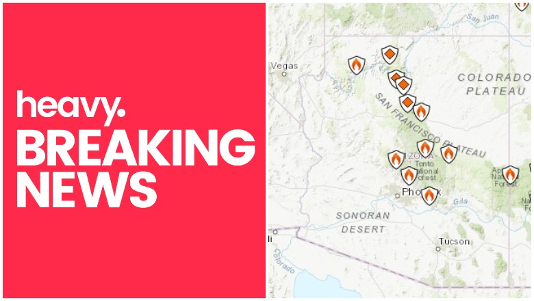
Inciweb Arizona Fire Map
The Woodbury fire (at greater than 100,000 acres in size) and other fires continue to cause concerns in Arizona on June 24, 2019. Smoke from the Woodbury Fire has even impacted other states. Read on for details about the fires, their locations, containment size, maps, and more.
According to Inciweb, a number of wildfires are burning in Arizona right now on June 24. You can see an interactive fire map for the Arizona area, provided by NWCG.gov. An embedded version is below, but click on the link to see a full version.
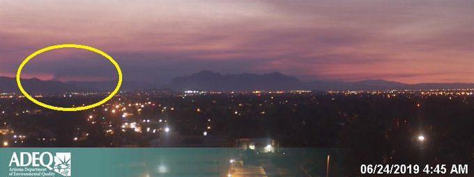
If you’re in the Phoenix area and seeing smoke, it’s likely from the Woodbury Fire.
Smoke from the Woodbury fire can clearly be seen from Phoenix this morning – this is the largest wildfire burning in Arizona right now.
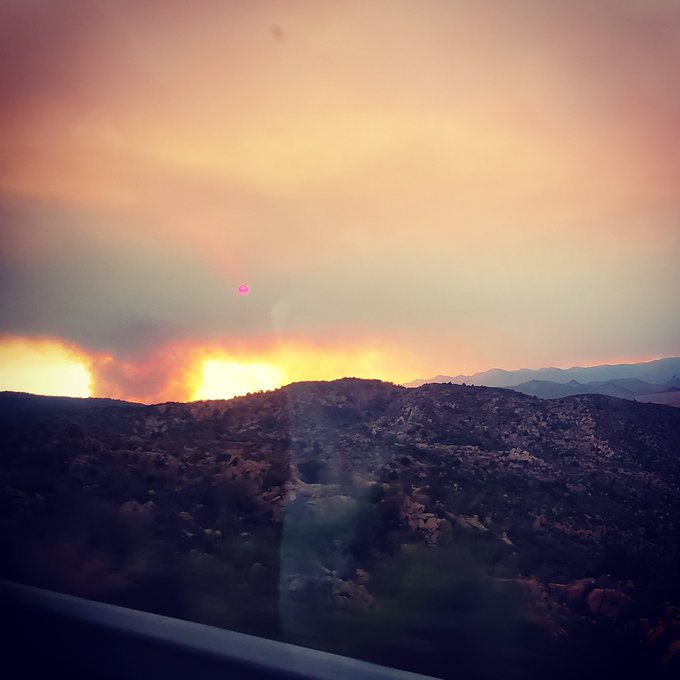
This fire is something. The red dot is the sun through the smoke haze.
Here are the fires currently in Arizona as of June 24, 2019, listed in alphabetical order, so the Woodbury Fire is at the end of this article. Some of them are prescribed fires that are set purposefully by officials to help prevent bigger wildfires from starting and spreading. Others are wildfires that you’ll want to keep a closer eye on. Remember that evacuation details can change rapidly, so stay tuned to your local news for updates. We will update this story again later in the day.
Badger Springs Fire
#BadgerSpringsFire UPDATE
Firefighters have made significant progress. No smoke visible. Resources are beginning to be released.
This fire is 2,525 acres and 45 percent contained as of the latest Inciweb update at June 22 at 9 p.m., Inciweb reported. (However, NIFC reports that it’s now 2,525 acres and 80 percent contained.) It started on June 21 and is three miles south of Cordes Lakes.
Use caution as you travel N on I-17 as smoke from #BadgerSpringsFire will be visible through the day E I-17. Info now available on inciWeb: t.co/YRKr1NBoPq
Inciweb wrote: “There are currently no threats to communities. Fire is 7 miles southeast of Cordes Junction at its closest point…The fire is burning within BLM lands east of I-17 including the Agua Fria National Monument, in an east-northeast direction. Light to moderate smoke may be visible east of I-17… While there is currently no threat to communities, we continue to work closely with Yavapai County in the event that conditions change.”
The cause of the fire is human activity and it’s under investigation.
Bylas Fire
The Bylas fire closed Highway 70 in Gila Valley temporarily on June 12. It’s near the community of Bylas between Globe and Stafford. Later all lanes on 70 were reopened.
According to NIFC, the fire is 340 acres and 90 percent contained, 25 miles northwest of Datil.
Coldwater Fire
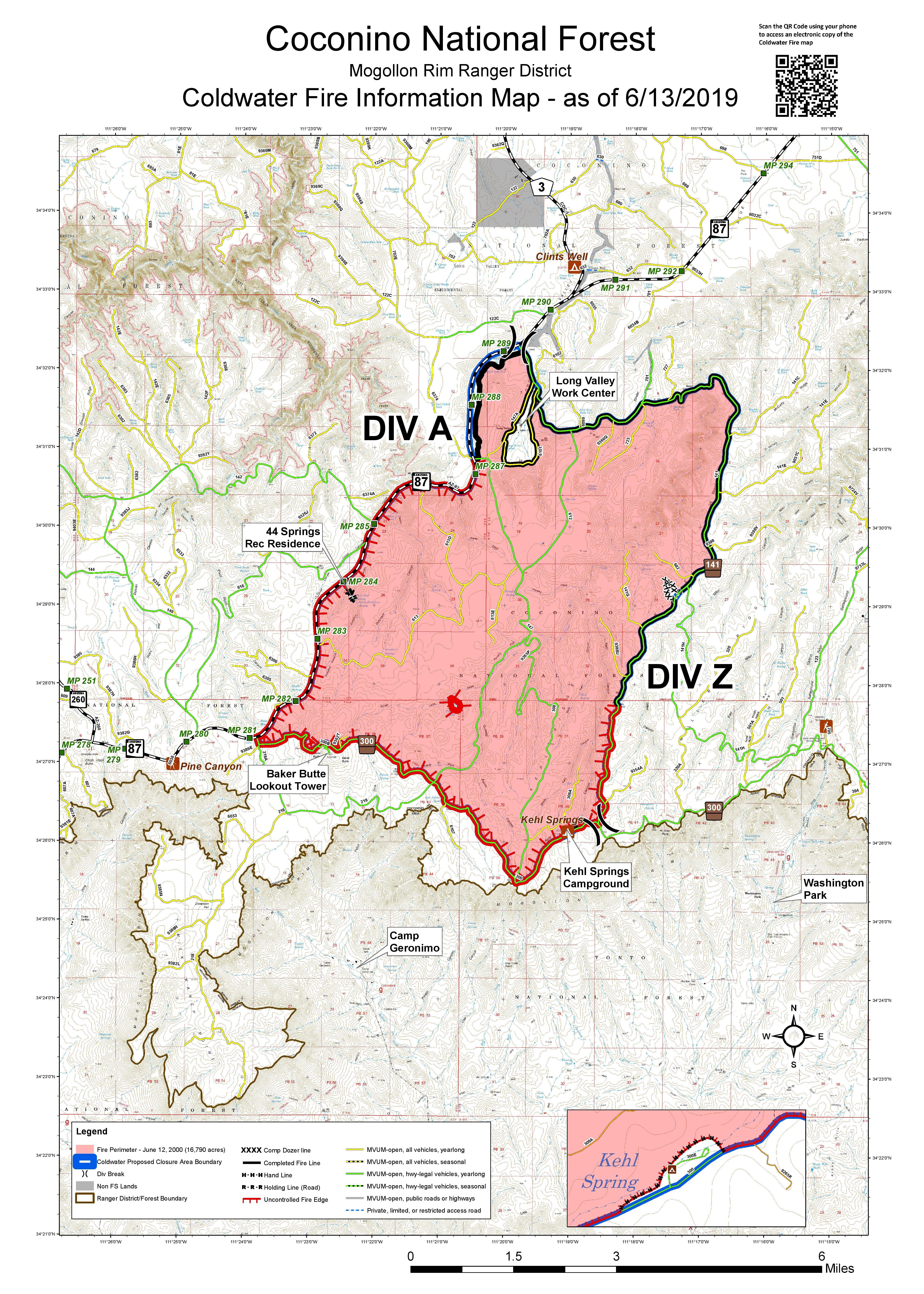
This fire grew from 9,665 acres on June 11 to 16,790 acres as of June 13, according to Inciweb. As of June 18 at 12:48 p.m., it was still 16,790 acres, but the good news is that it’s now 90 percent contained. The map above, from June 13, is the most recent map. Inciweb was last updated about this fire on June 18.
The fire was caused by lightning and is four miles south of Clints Well.
Inciweb noted: “Fire personnel with the Mogollon Rim Ranger District are currently monitoring the perimeter and remaining fire activity of internal smoldering pockets. A temporary forest closure remains in effect to ensure no one is injured or killed by the fire-weakened trees, burning debris and stump holes present in the interior of the fire. To review the closure go here. The public can expect to see minimal smoke from the Coldwater Fire for a few more weeks, but nothing substantial.”
Hoyle Fire
This fire is still listed as active on Inciweb. As of June 10, it was listed as 503 acres and 100 percent contained.
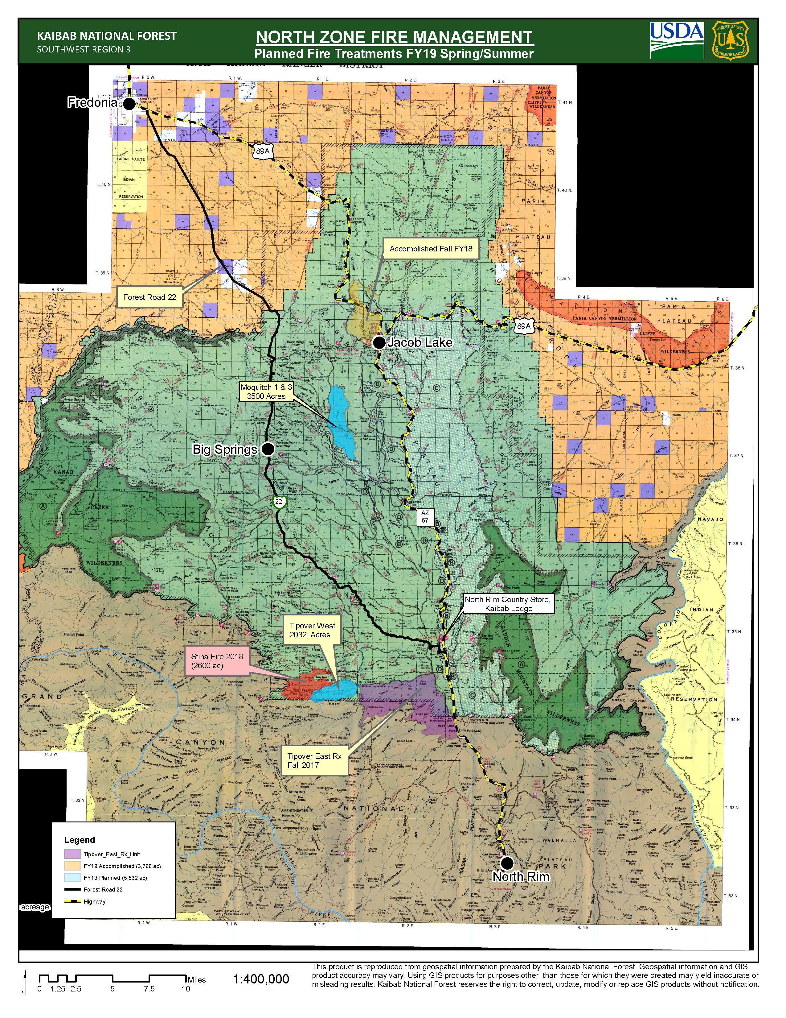
Kaibab Prescribed Fires (North and South Zones)
Inciweb
This is a prescribed fire, listed on Inciweb and divided into north and south zones. The map above is the north zone and it’s the most recent map released by Inciweb.
It’s 10 miles southeast of Williams. On June 20 Inciweb wrote: “Ignitions are complete on the Moquitch-3 (Phase 2) prescribed fire project at the North Kaibab Ranger District on the Kaibab National Forest. Fire managers have reported a total of 1,436 acres treated over the past two days.”
Inciweb wrote on June 23: “Fire managers on the south zone of the Kaibab National Forest will begin prescribe fire operations on the Tusayan Ranger Districts beginning Monday June 24th and will likely burn through the week. Ignitions will take place on the Russell Rx project located approximately 18 miles southeast of Tusayan. The goal of this project is to burn 2,130 acres clearing the area of flammable fuel sources that could prevent a potential wildfire from occurring.”
You can see maps of the south zone fires here.
The south zone fires include the Russell Prescribed Fire, the Sunflower Prescribed Fire, and the Reed Prescribed Fire.
Long Jim I & III Prescribed Fire
This is a prescribed fire in the Grand Canyon region to help prevent out-of-control fires.
Maroon Fire
This wildfire is currently 8,206 acres and is about 18 miles northeast of Flagstaff off Leupp Road near Maroon Crater, Inciweb noted in its last update about the fire on June 18. It’s 80 percent contained as of June 18. The fire was caused by lightning and is 18 miles northeast of Flagstaff, off Leupp Road near Maroon Crater, Inciweb noted.
Inciweb notes that the fire has transitioned back to a Type 4 fire, allowing resource numbers to be scaled back. However, the work isn’t completely over, KTAR noted on June 16. The focus is on controlling and managing the fire rather than putting it out, KTAR reported.
This fire is unique because the Maroon Crater was used for WWII artillery training and unexploded ordnance might still be off the designated roads, Inciweb noted. The fire has transitioned back to a Type 4 fire and fire teams will continue to secure holding features and reduce fire-related roadway hazards.
Mountain Fire
This fire is 7,470 acres as of June 18 at 12:03 p.m. and 100 percent contained. The last update on Inciweb was posted on June 18. The final acreage noted by Cal Fire on June 21 was much smaller at just 30 acres.
The fire was caused by human activity with the exact cause still under investigation. It was eight miles east of the Cave Creek Ranger District Office. It was first reported June 7 at noon and was completely in the Tonto National Forest.
Inciweb noted on June 18: “The Mountain Fire, 8 miles east of Cave Creek Ranger District office, is now 100 percent contained. Crews are on-site patrolling and conducting suppression rehabilitation work. Ash and dust whirlwinds may be visible. If you see smoke in the area of the fire, you are encouraged to call Phoenix Interagency Fire Center Dispatch at (480) 457-1555.”
Slate Fire
The Slate Fire showed up over the weekend in the Tonto National Forest region, but it was contained to 226 acres. It started near Highway 87 and temporarily caused traffic delays.
Slide Fire
This fire started May 1 and has not been updated on Inciweb since May 7, although it’s still listed on Inciweb as active. It was caused by lighting and is being managed. It is not an out-of-control fire. It’s 72 acres and burning 65 miles south of St. George, Utah.
Spring/Summer Prescribed Fire
This is another prescribed fire burning 10 miles north of Flagstaff. The size is about 1,190 acres and it will be a one-day operation.
Woodbury Fire in Tonto National Forest (Superstition Mountains)
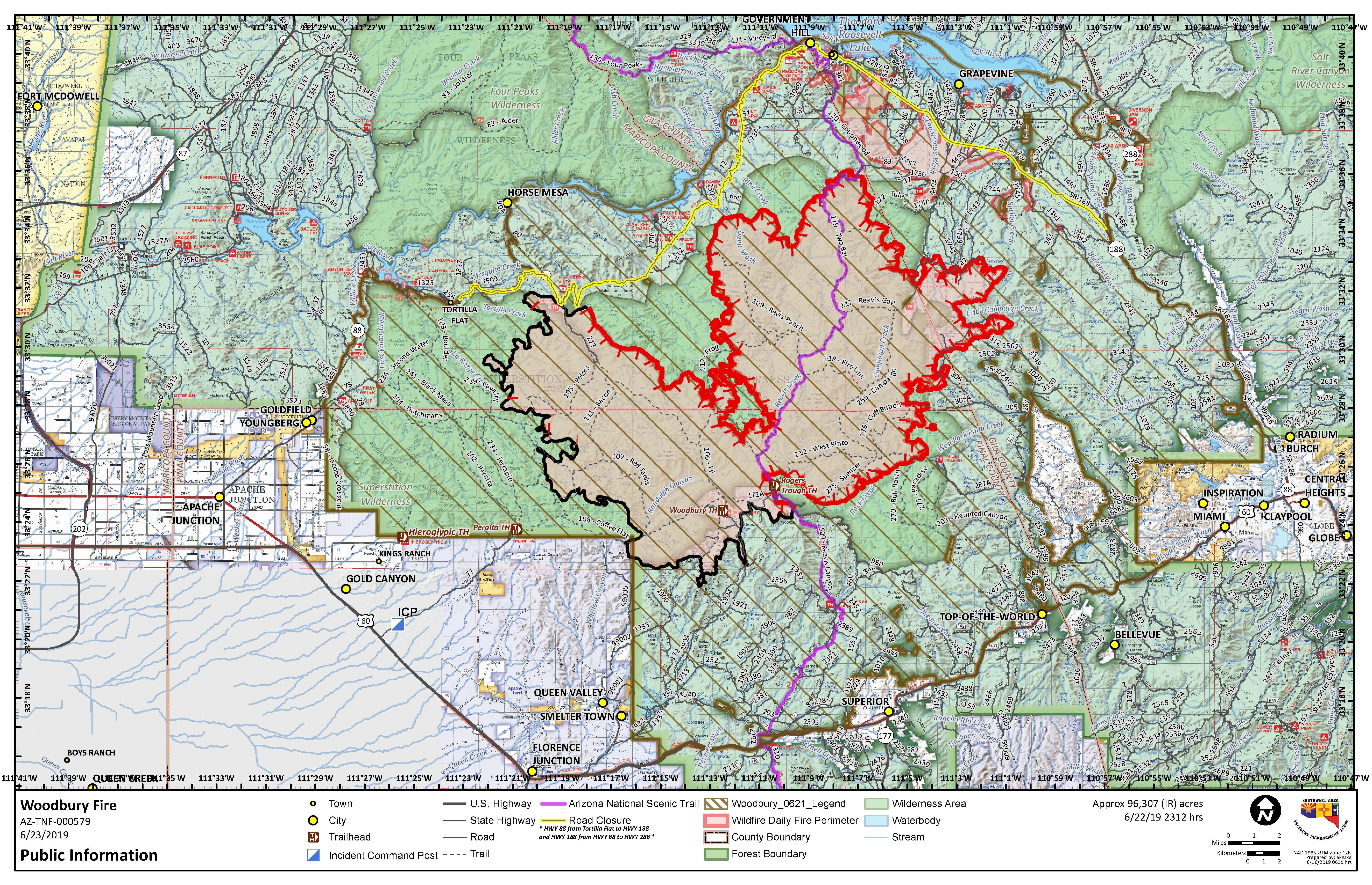
Inciweb
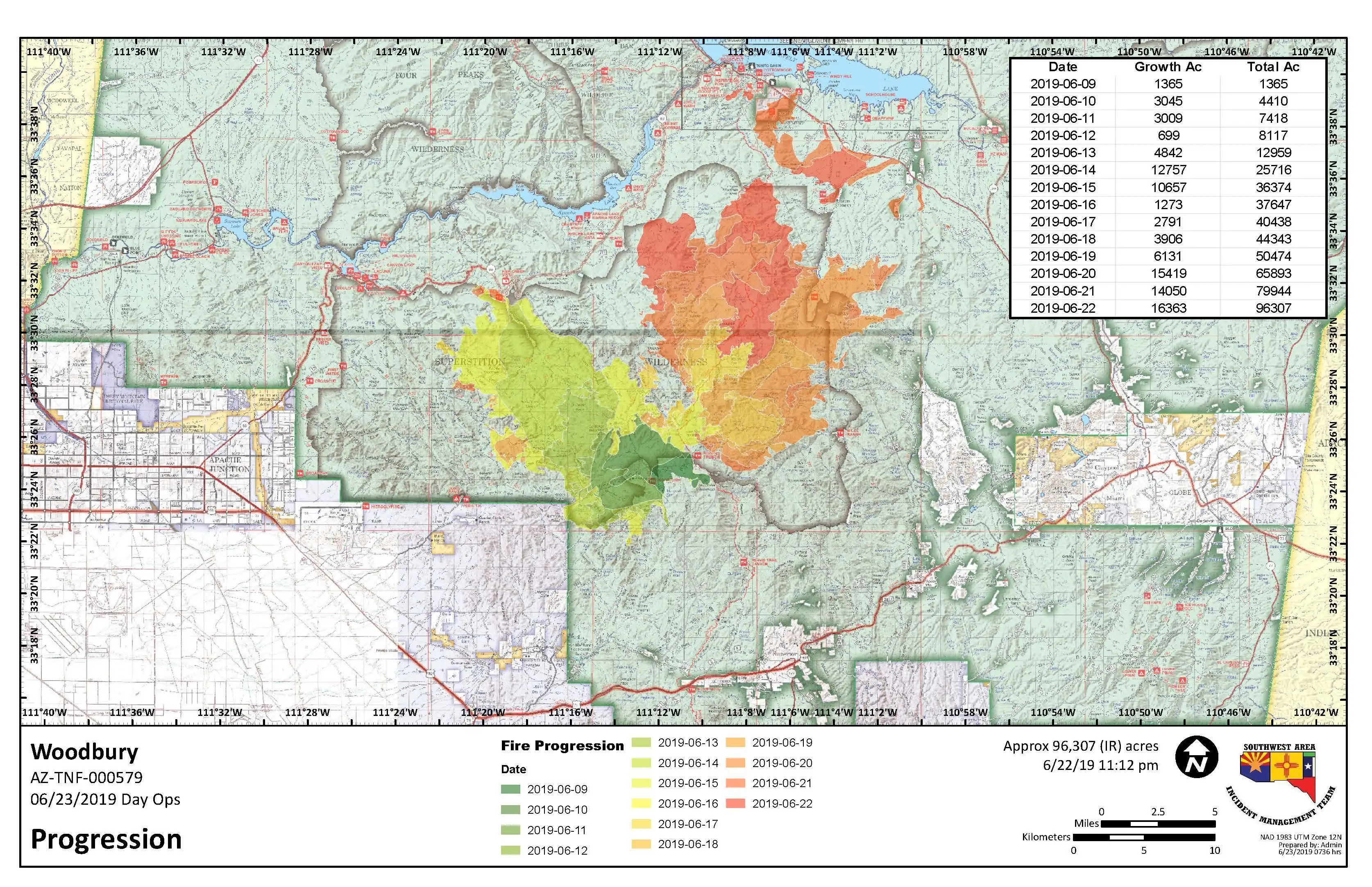
The Woodbury fire started out in the Superstition Mountains northwest of Superior, Arizona. It’s been the most troublesome of Arizona fires lately. It was 150 acres as of the evening of June 8 and was 5,000 acres as of June 11. On June 13 it was 10,090 acres and on June 15 it was 25,893 acres because of an unexpected dryline. On June 18 it was 40,557 acres in size and just 6 percent contained.
As of Sunday, June 23 at 8:45 p.m., the fire is now 96,307 acres and 25 percent contained according to Inciweb, but Fox 10 News reported that as of Monday morning, it’s now 112,899 acres and 25 percent contained. The cause of the fire is now listed as unknown on Inciweb rather than human-caused.
The following embedded map of the fire is provided by MappingSupport.com and Joseph Elfelt.
According to Inciweb, triple-digit temperatures over the next few days and single-digit humidity, along with increasing winds, might cause the fire behavior to increase.
Inciweb noted that there’s concern of active threats to critical infrastructure over the next 72 hours or more. Here’s a list of structures that could be at risk in the future, depending on fire and weather patterns:
- The Tonto National Monument
- 115kv powerlines and major 500kv powerline serving the Phoenix area
- Pinto Valley and Carlotta mines
- major infrastructure and transportation corridors not named
- private residences and commercial property
- riparian waterways
- endangered species, including the Mexican Spotted Owl
- Sonoran Desert ecosystem
The fire is currently moving north to Spring Creek Ranch, Cross P Ranch, and Highway 188. It also crossed over the Sawtooth Ridge approaching a wilderness boundary.
Firefighters are implementing protection points north and east of the fire to protect at-risk regions and air tankers are being used.
Here’s a look at the fire’s progression:
The Gila County Sheriff’s Office issued an evacuation alert on Thursday, June 20 for residents in the Roosevelt Lake area, KTAR reported. This alert included the Roosevelt community, where residents were told to leave immediately, bringing pets, medications, money, and valuables. They were told to close windows and doors before leaving. A shelter for evacuees has been set up at Lee Kornegay Intermediate School at 4735 S. Ragus Road in Miami Arizona. Livestock can be sheltered at the Gila County Fairgrounds. If owners can’t evacuate their livestock, they are asked to paint phone numbers on the animals and set them loose.
As of Monday morning June 24, additional evacuations have not been issued since the ones listed above, Fox 10 reported.
As of the evening of June 23, closures include (they are from Inciweb unless otherwise noted):
- “The Tonto National Forest closed the Superstition Wilderness and adjacent Forest and campgrounds along State Highway 188 east of Roosevelt dam.”
- “State Highway 88 is closed from mile post 213 at Tortilla Flat to State Highway 188 at Theodore Roosevelt Dam.”
- “State Highway 188 is closed from its junction with State Highway 88, east to the junction of State Highway 288 (The Young Road). Highway 288 remains open.”

InciwebClosure Map for June 20
Inciweb noted the following predictions on the evening of June 23:
24 hours: SW ridge winds diminish overnight reducing potential for rapid fire spread and downslope wind alignment issues. Interior pockets of fire spread are expected to continue in higher elevations with continuous heavy shrub fuels (with Pinyon Pine-Juniper mix). Expect minimal heat retention from previously fired areas. Significant increase in smoke production during firing operations, especially late evening and night time period.
48 hours: Continued hot/dry conditions likely to produce sustained burning conditions. Heavy shrub fuels at higher elevations (NE side of fire) will continue to produce pockets of very active fire behavior. Continued tactical firing operations to secure perimeter line, and provide additional burnout depth. Areas of upslope fire spread will merge with areas of fire on upper slopes, some interior unburned islands will likely remain. Unburned fuel pockets will cause flare up as they consume. Expect very little heat retention in areas where firing operations have occurred.
72 hours: Increasing S-SW winds, with hot/dry conditions continuing. Continued pattern of low RH and high temperatures maintain conditions favorable for fire growth. Greater portions of the fire will encounter fuel type change from heavy shrub fuels with Pinyon Pine and Juniper mix to lighter grass/shrub models. As necessary, tactical firing operations will continue to provide a of secure perimeter. Pockets of unburned fuels will consume between upper and lower slopes. Overall activity expected to become more focused on fewer portions of the fire area. Generally diminished amount of smoke.
Anticipated after 72 hours: Pattern of hot and dry conditions persist into the foreseeable future. Conditions will support very active fire behavior until the weather pattern changes. Increased atmospheric instability (Haines 5) through the week.
Two more updates should be released from Inciweb about this fire on June 24. This story will be updated to reflect those changes.
For updates: Follow Tonto Forest on Twitter, the U.S. Forest Service for Tonto National Forest on Facebook, Gila County Sheriff’s Office on Facebook, and the fire’s Inciweb page for the latest updates about the fire. For more details about evacuations and shelters, including pet shelters and livestock shelters, call 928-402-8888.