Utah Fire Info
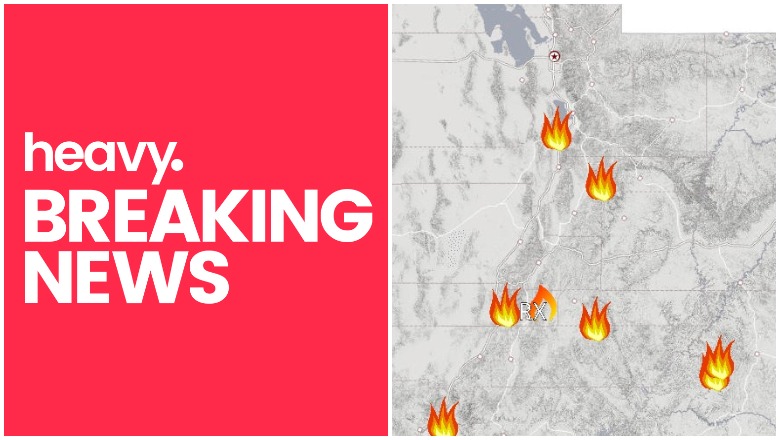
Fires are a big problem today in Utah, thanks to the hot, dry summer. The biggest fire right now is the large Goose Point fire, but there are others in the state too. Here is a list of the major active fires on August 22, 2019 according to Utah Fire Info, NIFC.gov, and other sources, along with maps on where the larger ones are located. Read on to learn more details and see maps of the fires in the Utah area, including fires in Salt Lake City.
You can view a map of all the Utah fires here. This map is being constantly updated, so very new fires may not be featured on the map until they’ve grown larger. You can see a screenshot of Utah Fire Info’s current map below.

You can also see a map of Utah fires in Inciweb’s map here. An embedded version from Google Maps that shows the Inciweb-listed fires in Utah is below. Depending on your browser, you may need to zoom into the map to see the Utah fires.
Read on for details about individual fires in the state. They’re listed in alphabetical order.
Avintaquin Ridge Fire
This fire is listed on NIFC but in no other location. It’s 111 acres and 80 percent contained, located 15 miles southeast of Fruitland.
Chippean Fire
#ChippeanFire 🔥 unofficial, automated update.
~15mi NNW of Blanding, UT. ⚠️ DO NOT USE FOR SAFETY PURPOSES – See officials instead. May be incorrect; disclaimers in images.
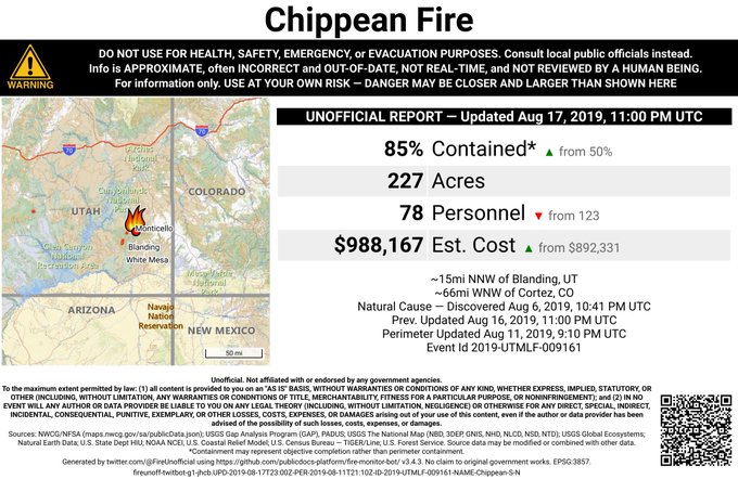
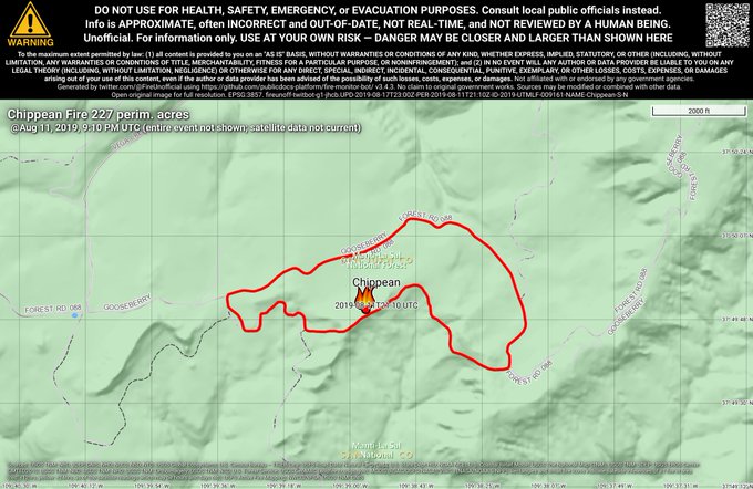
This fire, located near the Poison and Peavine Fires, is in the Manti-La Sal National Forest. As of August 15, the latest update from Inciweb, it was 227 acres and 20 percent contained. It’s well contained and the fire officials are letting “natural forces do their job and making sure the fire stays within established boundaries and behaves the way we want it to,” Inciweb noted.
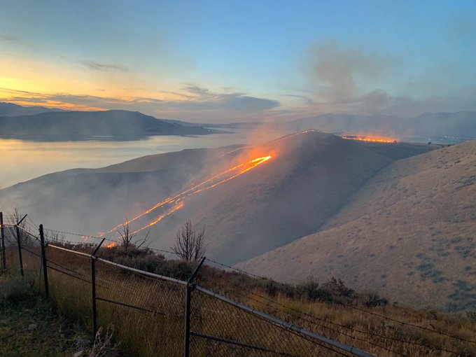
Goose Point Fire
Early reports this morning said the fire is 3,000 acres and 0 percent contained, according to Utah Fire Info. However, Utah Fire Info later updated these details and has said the fire is now 6,500 acres in size as of August 20.
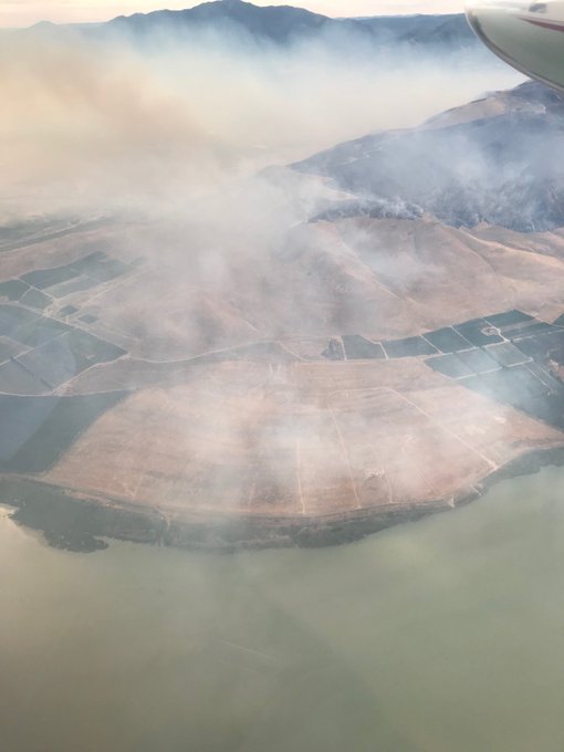
GPS mission over the #GoosePointFire shows 6,500 acres.
At the moment, no homes are threatened from the fire. But residents should watch the local news closely, since this can change with little warning.
Latest picture from the air over the #GoosePointFire
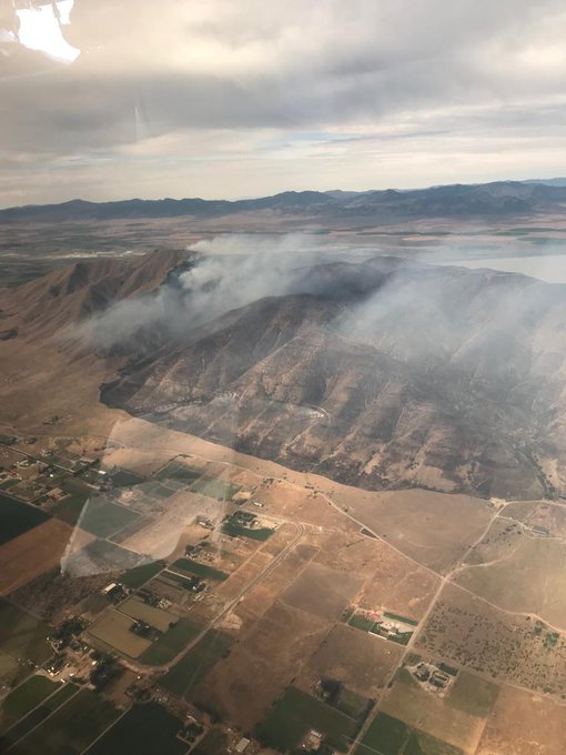
People at the BYU Observatory were evacuated safely off the mountain.
My dad is stationed at the BYU observatory and snagged some sweet pictures of the #GoosePointFire
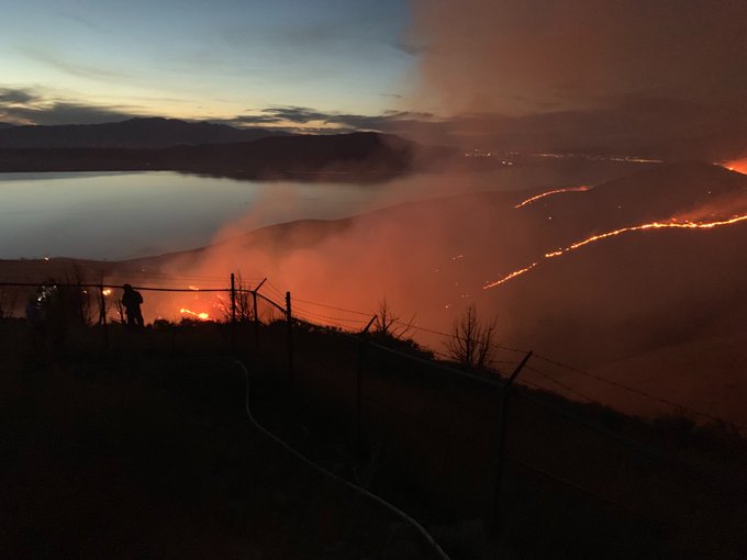
At the moment, fire officials believe they have protected homes and the BYU Observatory from the fire and will let the grass burn, KSL reported.
Here is a smoke forecast for the next two days, with some increases from the Goose Point Fire.
Here is the @forestservice‘s smoke forecast for the next 48 hrs. There will be moderate increases to PM2.5 from the #GoosePointFire along the Wasatch Frnt. High altitude smoke transport from ID and OR are also contributing to the darker skies today.
At this time, no evacuations have been issued for the fire, but stay tuned to local media for updates.
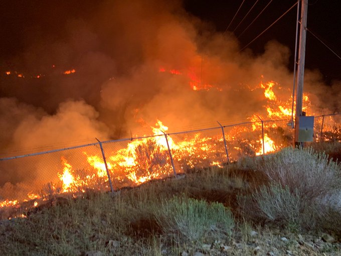
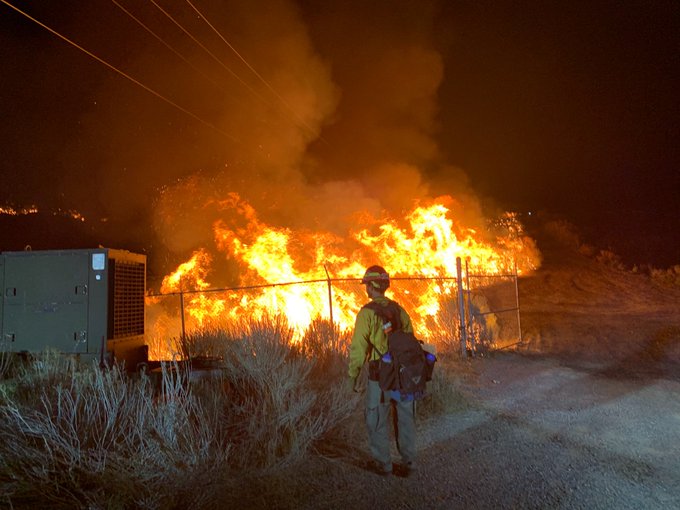
Photo from the #GoosePointFire looking west from Spanish Fork
LaVerkin Creek Fire
This fire is 10 acres, according to Utah Fire Info, and first discovered on August 20. It’s located near the southwest corner of Utah.
According to KSL, the fire started when chemicals spontaneously combusted from the heat after a man who was cleaning out a shed left them in a trash pile to be hauled off. The fire was near the La Verkin Creek bridge on Route 17, in north La Verkin. As of Wednesday it was 19 acres and 80 percent contained, KSL noted, so the latest information from Utah Fire Info’s map may not be accurate. Crews were able to keep the fire from spreading to nearby homes.
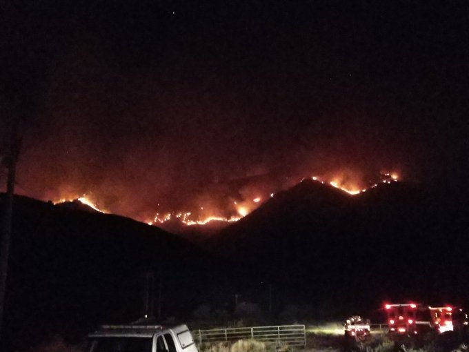
Little Bear Fire
#LittleBearFire 🔥 unofficial, automated update.
~7mi SE of Hatch, UT. ⚠️ DO NOT USE FOR SAFETY PURPOSES – See officials instead. May be incorrect; disclaimers in images.

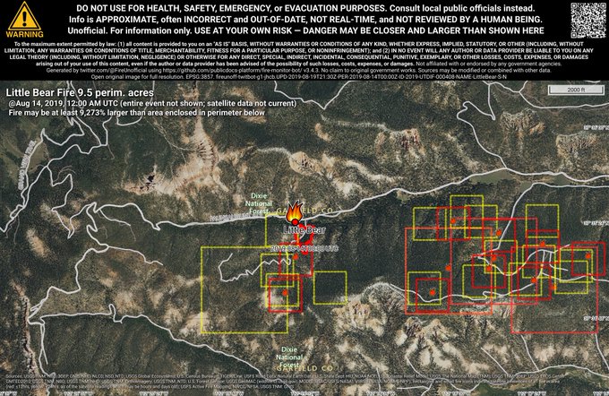
This fire was started on July 26. It’s seven miles southeast of Hatch, according to Inciweb. The fire is being monitored. It was caused by lightning. It’s grown to 850 acres, but it’s spreading north within prescribed boundaries.
On August 19, Inciweb noted that the fire is expected to be contained by September 14. It’s seven miles southeast of Hatch, Utah. Inciweb said: ” It is gradually spreading north and east within the identified boundaries of the planning area. As it burns naturally through the area, it can be beneficial to the fire-adapted ecosystem by removing fuels that could feed future forest fires.”
Mammoth Fire
#MammothFire 🔥 unofficial, automated update.
~7mi ESE of Fairview, UT. ⚠️ DO NOT USE FOR SAFETY PURPOSES – See officials instead. May be incorrect; disclaimers in images.
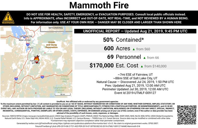
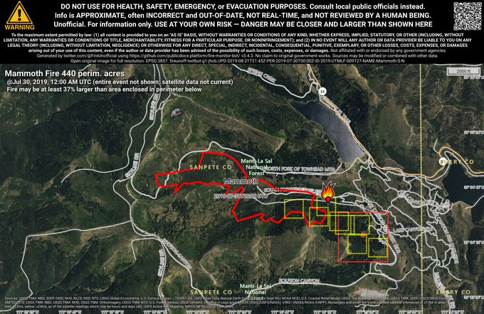
This fire started on August 7. It’s now 420 acres in size and 50 percent contained, according to Utah Fire Info (but other sources list it as being 600 acres in size and 50 percent contained.) It was caused by lightning and is being allowed to burn for resource benefits, to help cut down on the possibility of uncontrolled fires in the future.
The fire is seven miles east-southeast of Fairview, Utah.
Park Ridge Fire
This fire is 186 acres and 35 percent contained according to Utah Fire Info and Inciweb. It was caused by lightning. Utah fire info noted: “Fremont River Ranger District plans to manage this ignition to aid towards a healthy Ponderosa Pine ecosystem, by utilizing low intensity under burn tactics.”
It’s 10 miles south of Grover, Utah. The last update on Inciweb was August 15.
Peavine Fire
The Peavine Fire, located near the Poison Canyon fire, is 90 percent contained as of August 15, the latest update. It’s in the Manti-La Sal National Forest.
Poison Canyon Fire
#PoisonCanyonFire 🔥 unofficial, automated update.
~19mi NW of Blanding, UT. ⚠️ DO NOT USE FOR SAFETY PURPOSES – See officials instead. May be incorrect; disclaimers in images.

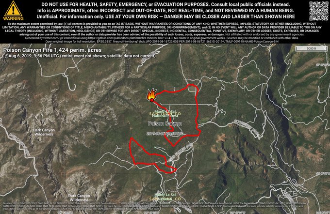
This fire started on July 26, 2019. It’s 1,105 acres and 85 percent contained as of August 14, the last Inciweb containment update. (Other updates say it’s 95 percent contained.) It was caused by lightning and is being overseen by the Manti-La Sal National Forest. The fire is 22 miles northwest of Blanding, Utah (19 miles northwest according to Utah Fire Info.)
On August 15, Inciweb noted that hikers might see smoke rising from two nearby fires if they’re near Peavine and Poison canyons. The Incident Commander said the fires are within the control lines. Incident Commander John Shaffer said: “This is eliminating heavy, hazardous material—the stuff that’s otherwise fuel for a more intense fire. And that is especially helpful in the Chippean Fire, which is burning at a low intensity inside a healthy stand of ponderosa pine that we aim to protect.”
Skull Flat Fire
#SkullFlatFire 🔥 unofficial, automated update.
~6mi E of Beaver, UT. ⚠️ DO NOT USE FOR SAFETY PURPOSES – See officials instead. May be incorrect; disclaimers in images.
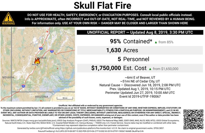
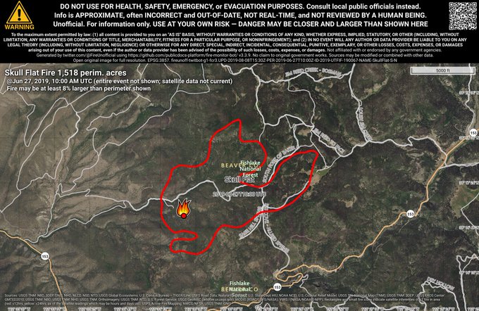
This fire is listed on Utah Fire Info’s map as active. It started on June 18, 2019 and grew to 1,630 acres and is 95 percent contained. The fire was caused by lightning and is about six miles east of Beaver, Utah. The latest update was in early August.