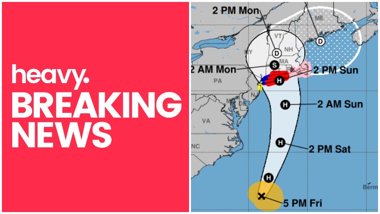
NHC NHC's forecast for Henri as of 5 p.m. Eastern.
The National Hurricane Center has released weather updates for Tropical Storm Henri on August 20, 2021. These updates include new watch and warning areas, along with predictions for the storm that is anticipated to become a hurricane before landfall. Here’s a summary of the latest updates for August 20 as of 6 p.m. Eastern.
You can read the full updates on the NOAA’s website here.
Tropical Storm Henri’s Location, Coordinates & Movement
NHC as of 5 p.m. Eastern.
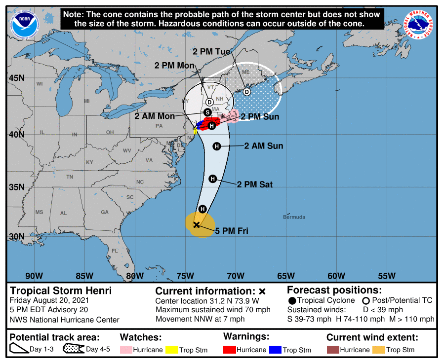
As of August 20 at 5 p.m., Henri was located at 31.2N, 73.9W about 290 miles south-southeast of Cape Hatteras, North Carolina, and about 695 miles south of Montauk Point, New York.
The storm is moving north/northwest (340 degrees) at 7 mph.
The National Hurricane Center noted at 5 p.m. that Henri was “almost a hurricane” and added:
At 500 PM EDT (2100 UTC), the center of Tropical Storm Henri was located near latitude 31.2 North, longitude 73.9 West. Henri is moving toward the north-northwest near 7 mph (11 km/h). A turn toward the north is expected by tonight, and Henri is forecast to accelerate in that direction through early Sunday. On the forecast
track, Henri is expected to make landfall in Long Island or southern New England on Sunday.Maximum sustained winds are near 70 mph (110 km/h) with higher gusts. Strengthening is forecast during the next day or so, and Henri is expected to become a hurricane tonight or Saturday and be at or near hurricane strength when it makes landfall in Long Island or southern New England.
Tropical-storm-force winds extend outward up to 115 miles (185 km) from the center.
The estimated minimum central pressure is 994 mb (29.36 inches).
Tropical Storm Henri’s Wind Strength & Pressure
As of 5 p.m., the storm’s maximum sustained winds were 70 mph, with higher gusts. Strengthening is expected, and the storm will likely become a hurricane sometime on Friday night or Saturday.
The minimum central pressure is 994 mb or 29.36 inches.
The storm may produce rainfall of three to six inches, with isolated areas near 10 inches. In addition, NHC warned: “The combination of a dangerous storm surge and the tide will cause normally dry areas near the coast to be flooded by rising waters moving inland from the shoreline.”
In a discussion from NHC, which you can read here, forecasters noted:
Henri appears to be slowly gaining strength. Deep convection has been increasing during the past few hours and the upper-level outflow continues to become better established on the east side of the circulation. However, the low-level center is still located near the northwestern edge of the deep convection due to ongoing northerly wind shear. An ASCAT-B pass from a few hours ago showed peak winds of around 55 kt, with the strongest winds on the southeast side of the circulation. Based on this data, the initial intensity is set at 60 kt. An Air Force Reserve Hurricane Hunter aircraft is scheduled to investigate Henri again this evening and the data the plane collects will be very helpful in estimating the storm’s strength and structure.
Current Watches & Warnings
According to the National Hurricane Center, the following warnings and watches are in effect as of 5 p.m.
Hurricane Warning:
- South shore of Long Island from Fire Island Inlet to Montauk Point
- North shore of Long Island from Port Jefferson Harbor to Montauk
Point - New Haven Connecticut to west of Watch Hill Rhode Island
Hurricane Watch:
- Watch Hill Rhode Island to Sagamore Beach Massachusetts
- Nantucket, Martha’s Vineyard, and Block Island
Tropical Storm Warning:
- Port Jefferson Harbor to west of New Haven Connecticut
- South shore of Long Island from west of Fire Island Inlet to East
Rockaway Inlet
Tropical Storm Watch:
- Manasquan Inlet New Jersey to west of East Rockaway Inlet New
York, including New York City
Storm Surge Warning:
- South shore of Long Island from Mastic Beach to Montauk Point
- North shore of Long Island from Oyster Bay to Montauk Point
- Greenwich Connecticut to Chatham Massachusetts
- Nantucket, Martha’s Vineyard, and Block Island
Storm Surge Watch:
- South shore of Long Island from west of Mastic Beach to East
Rockaway Inlet - North shore of Long Island from west of Oyster Bay to Flushing
- Flushing New York to west of Greenwich Connecticut
- North of Chatham Massachusetts to Sagamore Beach Massachusetts
- Cape Cod Bay
Additional watches and warnings may be issued, so stay tuned to local news for updates in your region.
READ NEXT: The latest COVID-19 variant details, cases, and vaccine updates