
CAL FIRE California fires near me
Here are the latest updates on all the fires in California as of October 7 and early morning October 8, with a roundup of maps of the larger fires around the state. News on the fires is constantly changing, so call your local officials if you are concerned about evacuations near you.
As you’ll note, one of the fires getting the most attention is a new fire in Solano County that can be seen in Danville. The Suisun City fire has grown to 1,000 acres as of Sunday early afternoon. There is also a new fire in Tehama County called the Sun Fire, and smaller fires noted in San Jose and Morgan Hill. These fires are not yet on CAL FIRE’s map, as of the time of publication, but are listed below. You’ll also note that the majority of the active fires currently on CAL FIRE’s map are actually no longer listed as active on Inciweb’s site.
This article first includes interactive maps for all of California. Then the second section details specific fires in the region. If you’re looking for a specific fire, scroll down or search for the fire’s name or your city’s name.
Interactive Maps of California Fires
This map below is an interactive map of the more significant fires in California, consistently updated and provided by CAL FIRE and Google. Fires in red are active and fires in black are contained. Read the next section for details about the fires listed on the map. You may need to zoom into this map to see California up close.
The California Governor’s office has another active fire map for comparison, which is embedded below. This map periodically is made available only to those with a login, so if it’s not available when you’re reading this story, it might be released to the public again later. This map includes a major incident summary for the day.
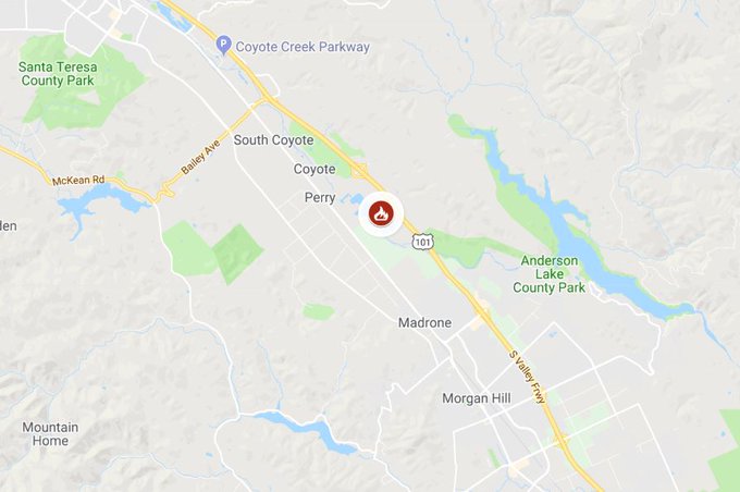
Below is another active fire map from Google’s Crisis Map. Zoom in to see areas of interest. This map also includes fires in other states.
You should also note that much of northern California is currently under a Red Flag warning until Monday morning:
Additional northern California counties are now under #RedFlagWarning until Monday morning due to gusty winds & low humidity. Use extreme caution when outdoors. t.co/jRrR4hFuqh

Next are more specific details on the fires for October 7 and early morning October 8. The details are extensive, so if you are looking for a specific fire, search for the name so you can find it faster, or just scroll down and look at the fires, listed in alphabetical order.
List of Active Fires in California
Here are the active fires and updates about them, per CAL FIRE. Most of these are in alphabetical order, but newer fires not yet listed on the CAL FIRE map may be included in a separate section at the end.
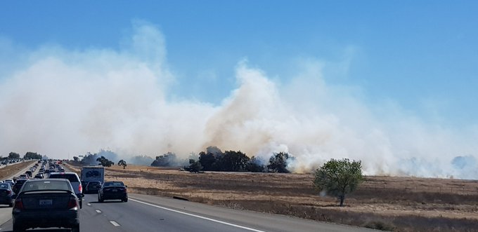
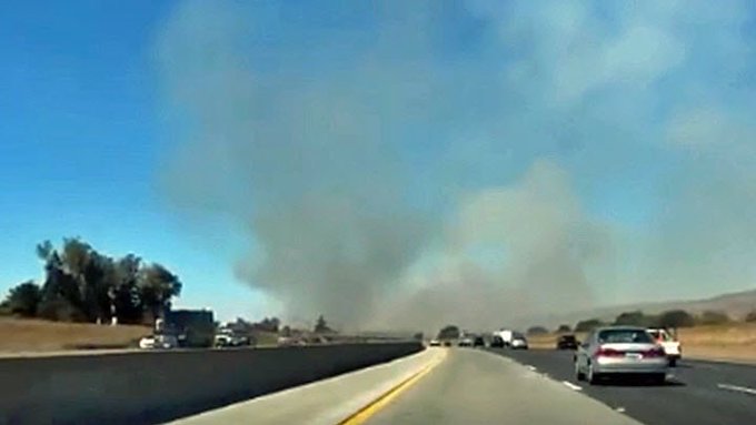
Branscombe Fire in Solano County/Suisun City
What started out as two small fires has led to one fire growing to 4,000 acres. Early reports from KTVU indicated that one of the two fires in Solano County may have grown to 1,000 acres. As of 4 p.m. Pacific, that fire had grown to 4,000 acres.
CAL FIRE is assisting @SolanoFire with a 4,000 acre fire off of Branscombe Road, south of Hwy 12, Suisun City (Solano County) #BranscombeFire t.co/NaqcGlBkm1

But the good news is that the fire is now at about 70 percent containment.
Fire spread across 4,000 acres now at 70% containment according to Suisun Fire Protection Officer Dennis Rein #branscombefire
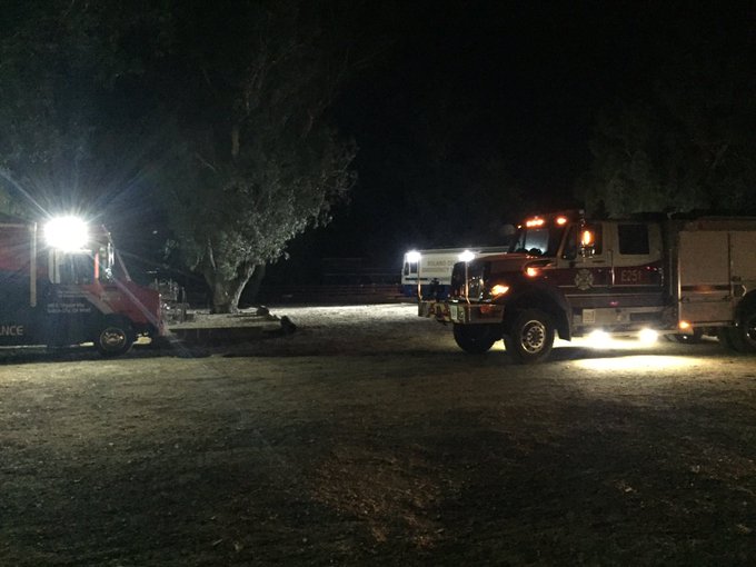

A Solano County fire was reported around 10:30 a.m. Pacific in Vacaville near Interstate 505 and Midway Road, and briefly caused the freeway to be closed, Patch.com reported. Thirty minutes later, another fire was reported on Branscombe Road in the Suisun District, and the road between Branscome and Walters Road is closed. KRON 4 reported that the road was later reopened, along with the lanes on EB and WB 1-80 to 1-505 N in Vacaville. However, KTVU is still reporting that Highway 12 between Suisun City and Rio Vista is closed due to smoke.
It is the second fire that has grown to 4,000 acres. The most recent report about the fire, issued on Sunday night, had it at approximately 4,000 acres. The fire grew so quickly because of high winds in the area.
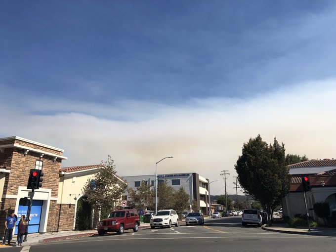
Smoke from the fires could be seen in Danville and in many other areas, causing people to wonder if the fires were closer than they were. The Danville Police Department noted on Twitter that there were no active fires in Danville, although a red flag warning is in effect.
DANVILLE PD: Smoke in the area is from Solano Co. fire. No active fires reported in our area. Red Flag warning remains in effect.
Napa County officials have noted that the fires are no threat to that area, although the smoke can be seen all the way there.
The fire’s smoke can also be seen in Alameda County.
Drift smoke is in the air in and around #AlamedaCounty this afternoon as a result of a four-alarm fire in Solano County. Please do not call 911 for this smoke. Red Flag conditions continue through Monday county-wide. Please be cautious outdoors and vigilant for any actual fires.
You can also see the smoke from the fires in Contra Costa County too:
HEADS UP: If you’re seeing smoke in Contra Costa County right now — it’s from 2 fires burning in Solano County t.co/KKdmMITgt6
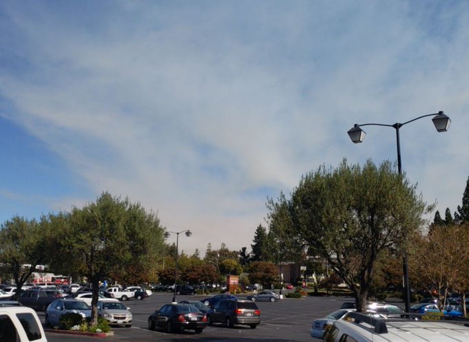
Fremont can also see the smoke:
Ash falling in #Fremont from Solano County Fire. Poor air quality. @nbcbayarea
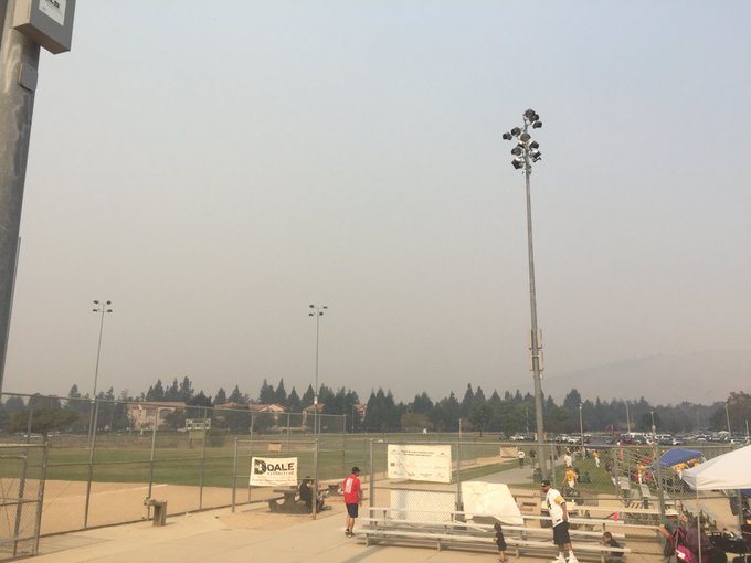
The smoke and smell from the fires are so strong that they’ve reached Cupertino too.
The stench from the Vacaville fires has reached Cupertino. Can’t imagine how awful it is for everyone else out there.
Some people have even noted that a smoke alarm in an apartment in Cupertino was triggered from the fires in Vacaville:
The smoke from these fires is also being reported in Santa Clara County and in Campbell.
This is a developing fire. It is growing rapidly and you should stay tuned to local news sources for updates. No evacuations have been ordered yet, CBS reported, but this could change so keep an eye on local sources. The CAL FIRE Twitter account is one good source. It’s likely that if the fire grows, a Facebook page or Twitter account dedicated to the fire may be established later.
Delta Fire
The Delta Fire is 63,311 acres and now 100 percent contained according to Inciweb, even though it’s still listed as active on CAL FIRE’s map. This and the Hirz fire have been declared 100 percent contained, though there may still be some minimal behavior and visible smoke.
Donnell Fire
This fire is in the Stanislaus National Forest and is 36,450 acres with 90 percent containment, as of October 1. This fire is no longer considered active, although CAL FIRE still has it listed as active on its map. Inciweb is no longer updating the fire page.
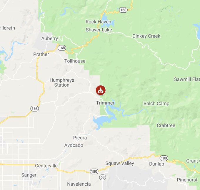
Eagle Fire
CAL FIRE notes: “CAL FIRE is assisting the Sierra National Forest with a fire off Bobs Flat Trail, 3 miles north of Trimmer (Fresno County).” The fire’s current status isn’t known. The most recent information is from October 2:
CAL FIRE is assisting @Sierra_NF with a fire off Bobs Flat Trail, 3 miles north of Trimmer (Fresno County). #EagleFire t.co/Ph4twbsPR3
Essex Fire
CAL FIRE is helping Modoc National Forest with this fire, which is located east of Essex Reservoir and northeast of Canby in Modoc County. The fire is still listed as active on CAL FIRE’s map as of September 19, but CAL FIRE hasn’t released any updates on the fire since September 4.
Fork Fire
“CAL FIRE is assisting the Angeles National Forest with a wildfire off East Fork Rd & San Gabriel Canyon Rd, Azusa (Los Angeles County),” according to CAL FIRE’s map listing. According to Inciweb, the fire is 166 acres and 98 percent contained as of October 4. This fire is no longer considered active and is not being updated by Inciweb daily.
Garner Complex Fire
Although still listed on CAL FIRE’s map as active, it is no longer considered an active fire by Inciweb, which is no longer updating details about it. It’s 8,886 acres and 85 percent contained as of August 9.
Georges Fire
This fire has been inactive for several weeks and is 95 percent contained, per Inciweb on August 24. It is still listed on CAL FIRE’s map, but Inciweb no longer considers it active.
Holy Fire
The Holy Fire formed on August 6 in the afternoon and quickly grew. The Holy Fire was in Orange County, off Holy Jim Canyon Road, west of the North Main Divide. As of September 13, the fire is 23,136 acres according to Inciweb and 93 percent contained.The fire is no longer considered active by Inciweb (although it’s listed as active on CAL FIRE’s map) and Inciweb is no longer updating details about the fire.
The cause is under investigation, but authorities have arrested Forrest Gordon Clark on suspicion of felony arson. Read more about Clark in Heavy’s story here.
Keenbrook Fire
According to CAL FIRE, this fire was off Cajon Blvd. and Kenwood Ave. in Devore (San Bernardino County.) The fire is 53 acres and 95 percent contained. There are no mandatory or voluntary evacuations in place.
Lions Fire
This fire is listed on the CAL FIRE map as active, but Inciweb no longer considers it active. It’s 13,347 acres and 85 percent contained as of October 1. It’s located seven miles southwest of Mammoth Lakes. It was caused by lightning. Most of the fire is on the Sierra National Forest, but about 1,600 acres are on the Inyo National Forest. The fire is now in monitoring status and is no longer considered active.
Morgan Hill Fire
This fire is not on CAL FIRE’s map, but was reported around 2 p.m. Pacific. It’s north of Dunne, close to the freeway, and fire crews are responding. More details are not yet known.
Fire near Morgan Hill north of Dunne. Fire crews just showed up.
(This may be the same as the Park Fire, listed lower in this story.)
Natchez Fire
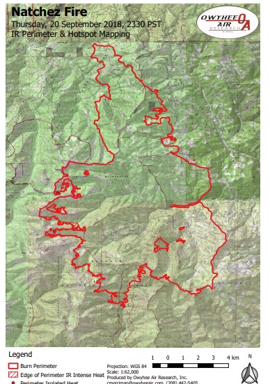
InciwebNatchez Fire Map
This Oregon fire falls under the jurisdiction of the Oregon Department of Forestry Fire, but is also listed on the CAL FIRE map. It’s 38,134 acres according to Inciweb, and 89 percent contained. It was caused by lightning. It’s located 15 miles southeast of Cave Junction, Oregon, located on the Oregon/California border between Happy Camp, California and Cave Junction, Oregon.
Inciweb issued its final update for the fire on October 7, unless conditions change. Widespread rain helped get the fire under control. Evacuation warning notices have been lifted. Trail and wilderness area closures remain in effect, although road closures have been lifted.
Park Fire in San Jose
#BREAKING: Brush fire sparks near Highway 101 and Coyote Creek Golf Club south of San Jose. t.co/YzN8w9GMKx via @KrisNBC
Another fire was noted in San Jose. This brush fire began near a golf course on Highway 101 south of San Jose, NBC noted. It’s 15 to 20 acres and was spotted around 2 p.m. Pacific. It’s near the Coyote Creek Golf Club and has since been reported as being 25 acres, off Monterey Road and Coyote Creek Golf Drive, north of Morgan Hill.
CAL FIRE is assisting San Jose City Fire with a 25 acre fire off Monterey Road and Coyote Creek Golf Drive, north of Morgan Hill, (Santa Clara County) #ParkFire t.co/ouR9lrpJCj
Santa Cruz Fire Near Depot Park
A fire in Santa Cruz was reported today near Depot Park, KION reported. However, it appears at least some of the current smoke being seen as of 3:30 p.m. Pacific is from other fires.
The county is receiving numerous reports of smoke in the area. This appears to be drift smoke coming into our county from fires elsewhere.
But there are some fires that the Santa Clara unit is reporting to:
There are several fires burning in the Santa Clara CAL FIRE Unit. We are experiencing lots of emergency calls regarding drift smoke impacting our county. If you can see flames or hear a fire, call 911. We currently have resouces patrolling the Santa Cruz Mountains.
Sun Fire in Tehama County
An 80-acre fire as started on October 7 off Highway 36 and Sunriver Drive, east of Red Bluff in Tehama County. By 3 p.m. Pacific , the fire had grown to 400 acres and was technically two fire, one 250 acres and one 150 acres.
But the fire grew even more than that, eventually reaching 3,848 acres, CAL FIRE reported late on Saturday night, with 40 percent containment.
Cal Fire indicates the following regarding evacuations:
- Evacuations Advisory for Stice Road and Andreni Road
- Evacuation Warnings for the Hogs Back Road area.
- Highway 36 is open with controlled traffic.
Stay tuned to your local media if you are in the area, as news such as evacuations can change quickly.
Valley Fire
The Valley fire is 1,350 acres and 82 percent contained as of September 28, which is the last time that Inciweb updated its information on the fire. It’s at the Valley of the Falls Dr. and Service Road 1S08. According to Inciweb, minimal to no growth is expected and very little fire spread is expected. However, hot and dry conditions have helped the fire stay active. Inciweb isn’t actively updating this fire daily anymore because of the long time before full containment will be reached.
Wilson Fire
This fire is at Wilson Lake Road and Lost Creek Road, 10 miles northwest of Chester in Tehama County. It’s 261 acres and 95 percent contained as of October 4. One outbuilding was destroyed in the fire’s initial stages, but no fire growth was reported later. Evacuations were lifted.
This is a developing story.
READ NEXT: Forrest Gordon Clark accused of starting a California fire