New York’s winter is about to get a whole lot messier. After a snow-free beginning to January, the city and surrounding areas about to get walloped by what figures to be the most severe storm to hit the region since Superstorm Sandy in 2012.
A front moving its way east from the Midwest — dubbed Winter Storm Juno by the Weather Channel — is set to pound the East Coast with blizzard-like conditions.
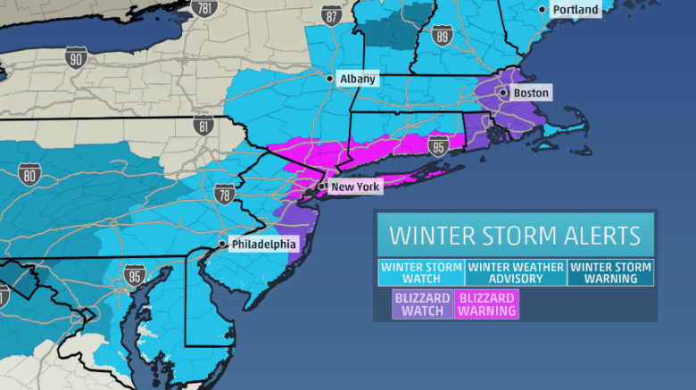
The East Coast is expected to get hit hard from Maine to Maryland, with Boston and the rest of Eastern New England getting hit the hardest. But the New York region is also set to get a heaping of snow from Monday into Tuesday morning, with most meteorologists predicting more than a foot of snow throughout the region.
The storm promoted Mayor Bill de Blasio to rev up his Twitter feed with warnings to New Yorkers to avoid unnecessary travel.

Please plan your day around tomorrow’s anticipated blizzard. Go to work early so you can leave early. Stay off the roads during the storm.
If you’re going to work today, please head home early – and take mass transit when you do. Stay off the roads as much as possible.
The National Weather Service issued a blizzard warning Sunday for an area stretching from northern New Jersey into southern Connecticut and including New York City and Long Island. The entire state of Rhode Island and most of Eastern Massachusetts are under a blizzard watch. Both advisories are in effect from Monday through Tuesday night.
The worst part of the storm is expected to hit Monday night into Tuesday, but snow and heavy winds are expected in the region throughout the day Tuesday and aren’t expected to go away until Wednesday morning.
The blizzard-like conditions are likely to bring the region to a crawl, making car travel next to impossible and potentially restricting air travel as well.
The storm has a chance to crack the list of New York’s highest snowfall totals, which CNN’s Brian Stelter tweeted about on Sunday.
Top NYC snowfalls:
Feb. 2006: 26.9″
Dec. 1947: 26.4″
Mar. 1888: 21.0″
Feb. 2010: 20.9″
Jan. 1996: 20.2″
Dec. 2010: 20.0″
Feb. 2003: 19.8″