Update: Tropical Storm Maria has been upgraded to a hurricane as of the 5 p.m. National Hurricane Center advisory.
Tropical Storm Maria will become Hurricane Maria on Sunday, according to the latest forecast. The storm has been brewing in the Atlantic for a few days and is heading west northwest, set to affect several islands in the Caribbean.
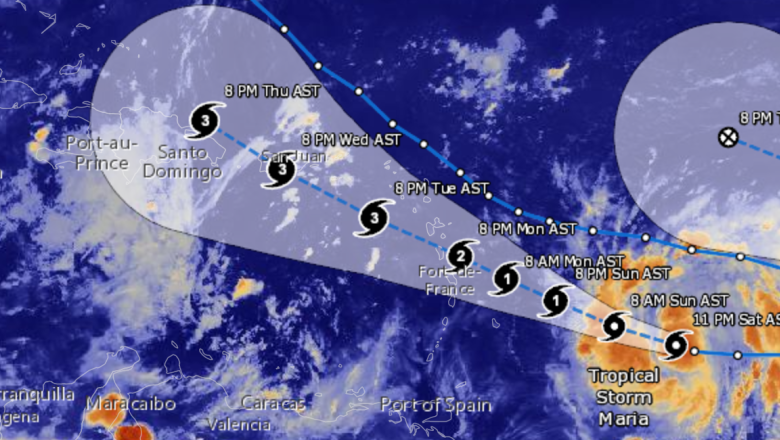
Maria may not look too aggressive right now but, as she heads toward Barbados at 15-20 mph, she is expected to intensify. As you can see in the photo below, Maria will become a Category 1 hurricane on Sunday afternoon, with winds around 75 mph. By Monday afternoon, Maria is expected to strengthen to a Category 2, with winds around 105 mph. As she sets her sights on Puerto Rico, Maria’s winds will increase yet again, and she will likely become a Category 3 on Tuesday.
Although Maria is not yet a hurricane, watches have already been issued in many Caribbean nations.
“Hurricane watches have been issued for Antigua and Barbuda, St. Kitts and Nevis, and Montserrat. Tropical storm watches have been posted for portions of the Lesser Antilles including, St. Lucia, Martinique, Guadeloupe, Dominica, Barbados, St. Vincent and the Grenadines. Tropical storm conditions are possible here on Monday,” The Weather Channel reports.
After Hurricane Maria passes the Dominican Republic, she may go in any direction. She could continue traveling north west, impacting Haiti, Cuba, and eventually Florida. Or, she may travel further north, impacting states along the eastern seaboard. The latest GFS and European models aren’t in sync at this time, but their projections are expected to change over the next week or so. Maria could impact Florida or North Carolina. There’s also a chance that she will go out to sea.
Further updates on Maria’s path will become available every few hours. Her exact track may not be known until she makes landfall.