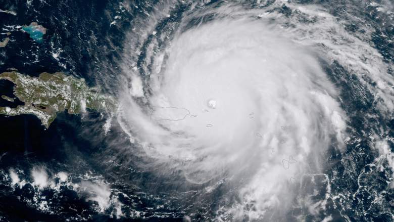
Getty
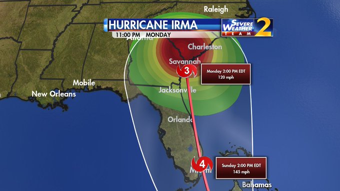
The latest Hurricane Irma forecast models for September 6 now show that some parts of Georgia might be in the path of the monster hurricane. The National Weather Service’s latest forecast says that hurricane conditions are now possible for Sunday night in Savannah.
The storm is unpredictable, though, and no one knows its path for sure. From the National Weather Service on the evening of September 6:
Georgia’s governor has declared a state of emergency in the following counties along the coast: Bryan, Camden, Chatham (where Savannah lies), Glynn, Liberty and McIntosh.

“Ahead of Hurricane Irma, I’ve issued an executive order prohibiting price gouging and waiving rules and regulations for motor vehicles transporting supplies, equipment, personnel, goods and services associated with disaster assistance and relief,” said Governor Nathan Deal. “This state of emergency also ensures aid for the six counties potentially impacted by this catastrophic storm. We will continue monitoring Hurricane Irma’s path in the days ahead and coordinating with our federal, state and local partners. I urge Georgians in the affected counties to remain vigilant and be prepare.”
Here’s the evening forecast cone from the National Weather Service, showing how the path has expanded to Georgia and South Carolina, while still threatening Florida:
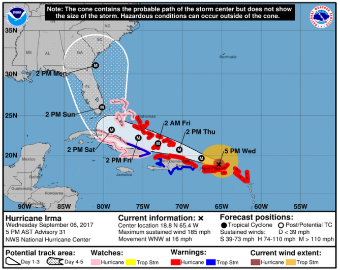
National Weather ServiceThe Hurricane Irma forecast cone as of 5 p.m. on September 6.
Watch the hurricane’s path here.
See updated Savannah weather here. Be aware that Savannah’s weather forecasts are charted through the Charleston, South Carolina office of the National Weather Service. See updated Savannah area radar here. See satellite infrared maps for Savannah. Get an hourly forecast for Savannah here.
Here’s a close up radar view of Cat 5 Hurricane #Irma to NE of #PuertoRico Eye is clearly visible. t.co/jwLK96qUuN
The latest update from the Charleston weather office serving Savannah reported on September 6: “Impacts associated with Hurricane Irma are expected this weekend into early next week. It is still too early to pin down the magnitude of the impacts as there remains uncertainty with the track the hurricane will take and how strong it will be as it approaches the Southeast United States. Everyone across Southeast South Carolina and Southeast Georgia, especially those in hurricane prone areas, should have a hurricane plan in place and continue to monitor the latest forecasts from the National Hurricane Center. Rip Currents: Long period swells generated by approaching Hurricane Irma will persist into early next week. These swells will enhance the risk for powerful and dangerous rip currents at area beaches into early next week as Irma draws closer to the region.”
Spaghetti models can provide further insight on the storm; the latest are generally showing it’s shifted to the east (which could be better news for Florida), while then charting a course toward Georgia and South Carolina.
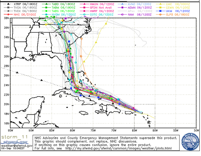
South Florida Water Management DistrictA September 6 evening spaghetti model.
See a September 6 PowerPoint on the local impact of Irma here. Note that the information in it could change because the hurricane remains unpredictable.
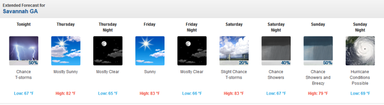
This is the latest detailed forecast for Savannah from the National Weather Service:
“Tonight (September 6)
A chance of showers and thunderstorms, mainly before 1am. Mostly cloudy, with a low around 67. Southwest wind 7 to 9 mph becoming northwest after midnight. Chance of precipitation is 50%. New rainfall amounts between a tenth and quarter of an inch, except higher amounts possible in thunderstorms.
Thursday
Mostly sunny, with a high near 82. North wind around 7 mph.
Thursday Night
Mostly clear, with a low around 65. East wind around 6 mph.
Friday
Sunny, with a high near 83. Northeast wind 7 to 13 mph.
Friday Night
Mostly clear, with a low around 66. East wind around 10 mph.
Saturday
A slight chance of showers and thunderstorms after 9am. Mostly sunny, with a high near 83. Chance of precipitation is 20%.
Saturday Night
A chance of showers after 9pm. Mostly cloudy, with a low around 67. Chance of precipitation is 40%.
Sunday
A chance of showers. Mostly cloudy, with a high near 79. Breezy. Chance of precipitation is 50%.
Sunday Night
Hurricane conditions possible. Showers likely, mainly after 9pm. Mostly cloudy, with a low around 69. Chance of precipitation is 60%.
Monday
Showers likely. Cloudy, with a high near 78. Windy. Chance of precipitation is 70%.
Monday Night
Showers likely. Cloudy, with a low around 69. Breezy. Chance of precipitation is 70%.
Tuesday
Showers likely. Mostly cloudy, with a high near 82. Chance of precipitation is 60%.
Tuesday Night
A chance of showers. Partly cloudy, with a low around 67. Chance of precipitation is 40%.
Wednesday
Sunny, with a high near 82.